wx2fish
-
Posts
2,631 -
Joined
-
Last visited
Content Type
Profiles
Blogs
Forums
American Weather
Media Demo
Store
Gallery
Everything posted by wx2fish
-
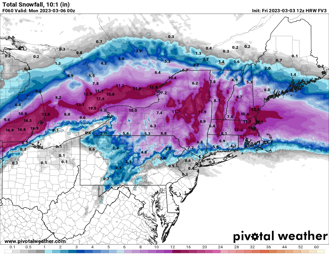
Pretty saggy here. Had some good gusts around 7 that knocked some off, but since winds went north its been pretty calm and stacking up again.
-
Just hit 6" here too on deck without clearing
-
This round is ending up better than I thought here. Pounding
-
Over 5.5" now. Band is definitely adding up, albeit slower than these rates should if it was a degree colder
-
Radar definitely blossoming a bit along 495/NH border region
-
5.0". Probably mod now with icy flakes
-
Rate is back up in this MA border band. Flakes are still pretty icy though
-
I think we can still add a little but itll become mroe rate dependent. Those echoes to southwest are the ones to watch as they build ENE. Hrrr/Rap both still enhance those across southern NH for a few hours later this morning.
-
A little over 4.5" so far
-
Looks like the 18z euro juiced it up a little more
-
Don't hate it either. If tomorrow's ccb stuff actually pans out I could see higher totals, but Ive been thinking 6-9" here.
-
12km went pretty wild for SNH, 3km more tame though
-
Nam juiced up the thump a bit in SNH
-
Pretty wild tomorrow with the ccb too. Still hard to buy, but that would be a wild couple hour ending
-
Nam is pretty good tomorrow in eastern Rockingham into SW ME
-
Soundings for SNH are well below freezing through the column on the hrrr. My guess is the sleet coloring on the maps is showing up from a dry dgz with lower level lift. Could just end up crap flakes vs sleet, but there is a ton of dry air aloft.
-
That's a pretty violent finish for SNH on the hrrr. Well see what the other mesos look like
-
Looks like the AFN coop is at 52"
-
Unless we get a full gfs look, the dgz dries right out after 15z. So, I'd agree there
-
Still pretty ugly, but south and better for SNH and NE MA.
-
Even if sniffed something out here, loop the last 3-5 runs for around ORD. Absolutely brutal performance
-
Meanwhile, 3k looks a little snowier here than 12z
-
Differences for ORD have been comical. Most everything else trended toward a meh event and the nam still hammers them. It was a trend south out there tho.
-
Kraft gone wild there sat.