SlowerLowerDE
-
Posts
143 -
Joined
-
Last visited


-

2020 Mid-Atlantic Severe Weather - General Thread
SlowerLowerDE replied to Kmlwx's topic in Mid Atlantic
It looks to have lifted. The warning is canceled. Thank God. -
2020 Mid-Atlantic Severe Weather - General Thread
SlowerLowerDE replied to Kmlwx's topic in Mid Atlantic
Oh Lord, we have another tornado coming in this direction! This is getting real old.
-
2020 Mid-Atlantic Severe Weather - General Thread
SlowerLowerDE replied to Kmlwx's topic in Mid Atlantic
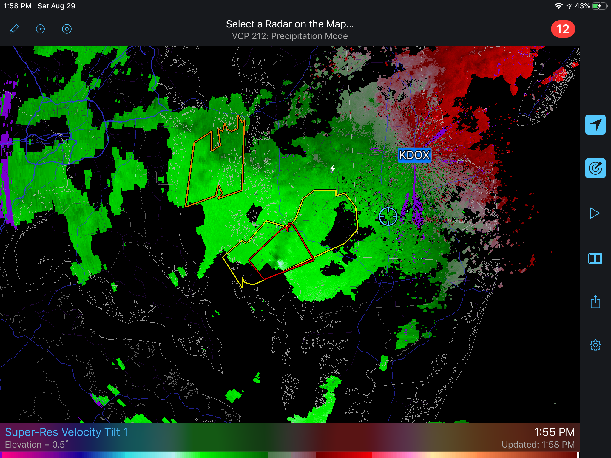
C.A.P.E. On radar south Dover looked like it got a pretty good hit from a tornado. I could not tell if it was the same cell that came by your or not. It was a separate warning. -
2020 Mid-Atlantic Severe Weather - General Thread
SlowerLowerDE replied to Kmlwx's topic in Mid Atlantic
Yes, that is easy to believe. One gust in particular bowed a huge Maple tree over. The tree survived but wow! -
2020 Mid-Atlantic Severe Weather - General Thread
SlowerLowerDE replied to Kmlwx's topic in Mid Atlantic
From Mt. Holly: NEAR TERM /UNTIL 6 PM THIS EVENING/... Its been an interesting couple of hours this morning as the warm frontal rainfall generally fell east of where we had anticipated it. We`ve seen generally 0.5-1" of rainfall east of the I-95 corridor and across DelMarVa. Based on forecast RFC Flash Flood Guidance, and DOT reports have confirmed, this has been causing the potential for some ponding of water over roads and areas of poor drainage. The pressing issue is that right behind the rainfall fall we`ve seen significant increases in reports of stronger winds. Looking at one hour pressure changes in the HRRR and from obs in the area we`ve seen all the signatures of a gravity wave propagating through the Mid-Atlantic. We`ve issued an SPS to highlight this threat. Moving forward into today, SPC has expanded the SLGT just a bit further north and we think that today`s set up to be an impact day with regards to convection. The timing of the threat should run from around noon through 8pm on the late side. Based on our mesoanalysis forecasters thoughts, we should see initially discrete cells moving through before coalescing into a line of storms. All of the typical steering flow indicators, deep layer shear, bunkers-right, and storm relative flow all is oblique to the boundary. This should mean that as the storms approach the I-95 corridor we`ll be looking at a QLCS event with the potential for rotation along the line. -
Southern MD / Lower Eastern Shore weather discussion
SlowerLowerDE replied to AnEndlessMaze's topic in Mid Atlantic
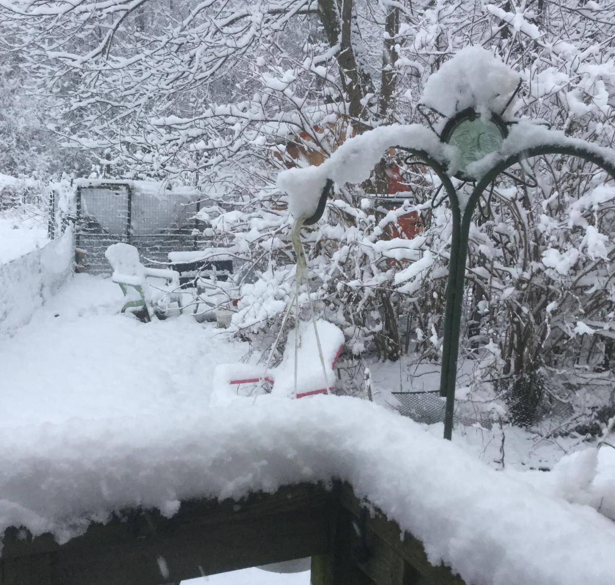
We have over an inch of snow here near Laurel. Now it is sleeting. This thing may over perform what the forecast is. -
Southern MD / Lower Eastern Shore weather discussion
SlowerLowerDE replied to AnEndlessMaze's topic in Mid Atlantic
I reported 9 inches to CoCoRaHS. I think we got more than that but it was impossible to measure so I was conservative. This storm had more impact than last years simply because the winds were so strong. Much more drifting with this event. Also the temps are much colder. Sussex county is still shut down today. -
Southern MD / Lower Eastern Shore weather discussion
SlowerLowerDE replied to AnEndlessMaze's topic in Mid Atlantic
I remember reading your posts. Enjoyed seeing you and your lady on the OC boardwalk cam. Fun times! -
Southern MD / Lower Eastern Shore weather discussion
SlowerLowerDE replied to AnEndlessMaze's topic in Mid Atlantic
We needed this rain badly and I am thankful that we got it. When I saw the radar yesterday evening showing a warm river of rain being pulled directly out of the gulf I knew that a lot of people were going to be disappointed with their "snowstorm." Onto Spring. -
Southern MD / Lower Eastern Shore weather discussion
SlowerLowerDE replied to AnEndlessMaze's topic in Mid Atlantic
I agree. None of the models are showing much if anything for my area. I hope we get a fair amount of moisture. We need some badly. I am ready for Spring. -
Southern MD / Lower Eastern Shore weather discussion
SlowerLowerDE replied to AnEndlessMaze's topic in Mid Atlantic
You look to have about the same as we do near Laurel. Being at the coast you should finish a bit higher than we do. That is okay. I have been shoveling this stuff and will have to do a second round when the snow ends. Am thinking about buying a snow blower as my husband had a mild heart attack in early December and it is all up to me now. -
Southern MD / Lower Eastern Shore weather discussion
SlowerLowerDE replied to AnEndlessMaze's topic in Mid Atlantic
It looks like about 7 inches here in Laurel. Could be a little more. The wind is starting to pickup up and the snow is still coming down heavily. When the wind gusts it is almost a whiteout. This fluffy stuff is going to really drift. It should get interesting even after the snow shuts off. -
Southern MD / Lower Eastern Shore weather discussion
SlowerLowerDE replied to AnEndlessMaze's topic in Mid Atlantic
We have over 5 inches and it is still snowing lightly. The Oldtimers would have called this the Onion snow. After it melted they would plant onions. They always said snow made the soil more fertile.
-
Southern MD / Lower Eastern Shore weather discussion
SlowerLowerDE replied to AnEndlessMaze's topic in Mid Atlantic
Declan is sure a cute little guy. At my age I'd rather look at babies than snow. In 2-10 it took eight days to get a plow on our streets. I think this was the perfect storm for us. We got about eight beautiful inches with little sleet or ice. Very enjoyable to watch it come down. In a couple of days we will be back to normal as it warms up. Spring is not far off. -
-