Avdave
-
Posts
10,688 -
Joined
Content Type
Profiles
Blogs
Forums
American Weather
Media Demo
Store
Gallery
Everything posted by Avdave
-
We actually call it Lake Effect snow back in WV and Western MD and Western PA Allegheny Mtns. Like eyewall said, its just mpisture from the Great Lakes, well primarily Erie transporting the moisture into the mtns and it gets squeezed out in the higher elevations. Thats how Snowshoe gets so much of their snows there, well natural snow it is all mainly lake effect
-
Hey MA folks, Question for you, What is Clarksburg, Md like and is it a good place to live or anywhere like Germantown up to Urbana? I havent been there in so long Im sure its all exploded with growth.
-
Thank God this winter is almost over. Its been taken behind the woodshed and beat the Fuuck up badly. It sucked overall. Only good part was the cold temps. But another season with less than 3" here. what else is new. I guess I can put the snow shovel away,........................oh wait I never took it out
-
Man some are grasping lol, posting maps that snow a half inch. Big deal
-
I have def noticed it more so lately. I dont understand it. Its just snow as yes I love it but Im not going to wish anyone else that they get shut out whether they are in Florence, SC or Bangor, ME.
-

Potential 1/28-1/30 2022 winter storm
Avdave replied to Prismshine Productions's topic in Southeastern States
Another Mehm but Ill take it, snow is snow. .4" here by the airport -
Your infatuation with New England getting screwed is really bizarre. Not sure why all the hate for a region because they are in a much colder climo and in a good location for snows.
-
Potential 1/28-1/30 2022 winter storm
Avdave replied to Prismshine Productions's topic in Southeastern States
Nary a flake here by RDU unless I missed that one falling when I stopped looking out the window. this system is a joke down here -
Potential 1/28-1/30 2022 winter storm
Avdave replied to Prismshine Productions's topic in Southeastern States
Meanwhile its S+ in Richmond, VA right now. -
Potential 1/28-1/30 2022 winter storm
Avdave replied to Prismshine Productions's topic in Southeastern States
Its a rain/Snow mix at CLT right now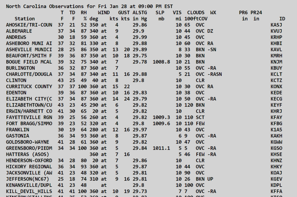
-
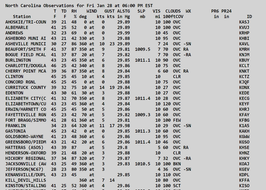
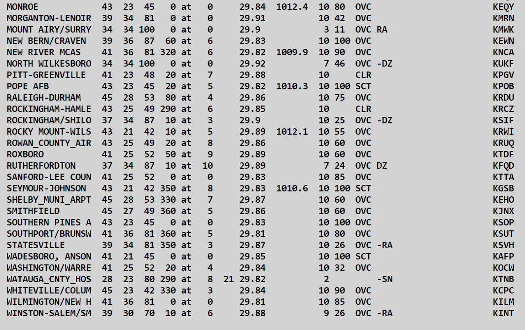
Potential 1/28-1/30 2022 winter storm
Avdave replied to Prismshine Productions's topic in Southeastern States
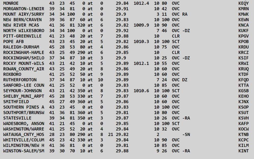
6pm obs statewide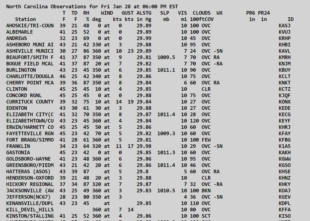
-
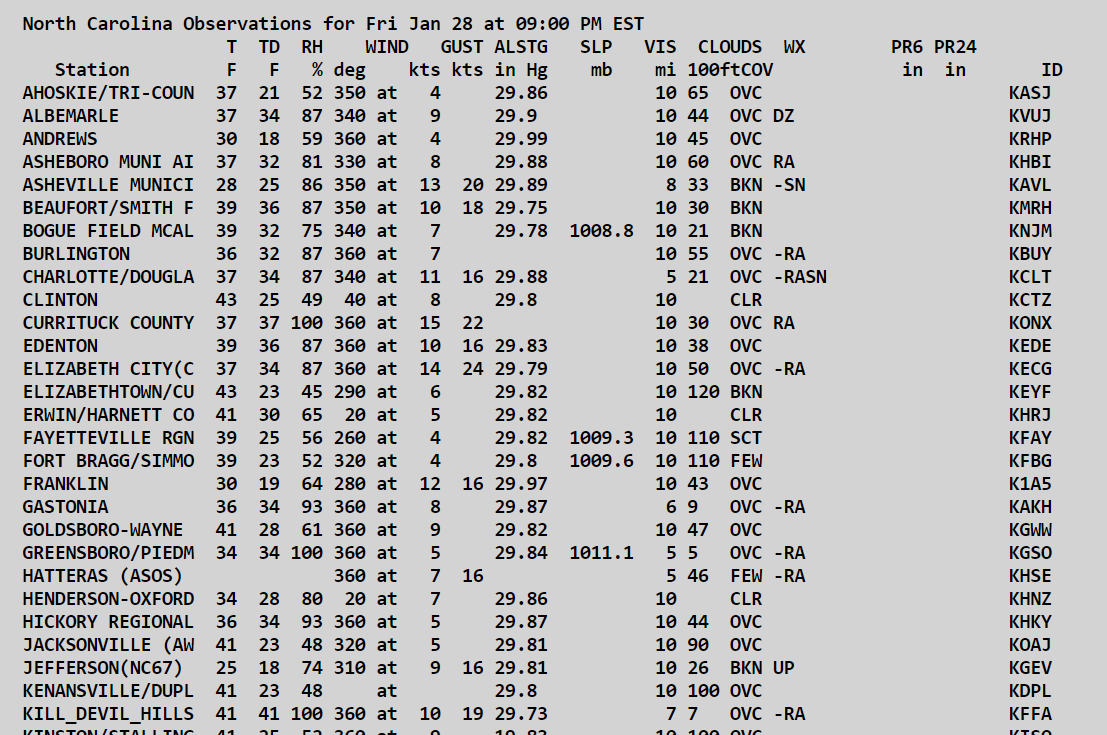
1/28-1/29 Winter Storm Obs Thread
Avdave replied to Prismshine Productions's topic in Southeastern States
OVC skies and a temp of 46 with a dew of 30 Expecting a half inch snow tops here -
Its a paywall so you wouldnt have been able to read it
-
Greg Fishel got a new gig. Good for him By Laura Brummett – Staff Writer, Triangle Business Journal 5 hours ago Greg Fishel, the former longtime chief meteorologist at WRAL who left the station nearly three years ago, has a new job in North Carolina — and it’s with an HVAC company. A favorite among WRAL viewers for decades, Fishel resigned from the station in February 2019. Since then, he has worked as a senior atmospheric scientist, moved to Florida, started a Facebook page dedicated to the weather and moved to Myrtle Beach, South Carolina, according to his social media accounts. His newest role is as a spokesperson for Blanton’s Air, Plumbing & Electric, a Fayetteville-based company with operations in the Triangle. As an HVAC company, much of Blanton’s services rely heavily on weather forecasting, said Madison Creech, Blanton’s marketing coordinator. The company also installs generators, another seasonal business dependent on weather, she said. “We thought that having our own weather person would be a fun way to get customers engaged,” she said. “Also, I think most people who grew up in this area know and love Greg Fishel, so that's kind of where the idea came from.” Fishel couldn't be reached for comment. He has already shot a commercial for the company. In it, he appears to be on a beach acting as Tom Hanks’ character in the film "Cast Away." Complete with a Wilson volleyball friend, Fishel is “found” by Blanton’s mascot, Coolidge. He then returns to what looks like a TV station and gives a weather report, shouting out Blanton’s heating technicians. Enlarge Screen shot of a commercial featuring Greg Fishel for Blanton’s Air, Plumbing & Electric. BLANTON'S C/O FACEBOOK e Fishel most recently worked for Priogen Energy as a senior atmospheric scientist from October 2019 till July 2020, according to his LinkedIn profile. In October 2020, he started a Facebook page titled “The O'fishel Weather - and other stuff PAGE.” The description says he uses it to share weather, climate and critical thinking tidbits to the page’s 20,000 followers. Some of his posts describe him traveling across North Carolina and beyond “chasing” weather events. Most posts get thousands of likes, followed by hundreds of comments expressing users’ love for Fishel and his content. Many include his humor, such as this Jan. 15 post, “Snow in the Triangle is like the Mets winning the World Series. It's not unprecedented, but darn is it hard to pull off!” Fishel started at WRAL in 1981 and became chief meteorologist in 1989. His sense of humor and weather reporting won the hearts of thousands of North Carolinians, making his departure from WRAL in 2019 shocking to many. At the time, Fishel gave a statement announcing that his resignation had been accepted. “I have been facing many personal challenges over the last year, and these issues have impacted my ability to work effectively and professionally,” he said at the time. “I take full responsibility for my actions and intend on meeting these challenges head on.”
-
Potential 1/28-1/30 2022 winter storm
Avdave replied to Prismshine Productions's topic in Southeastern States
So basically youll get snow while few miles west nothing. Very similar to the summer storms here lol. -
Potential 1/28-1/30 2022 winter storm
Avdave replied to Prismshine Productions's topic in Southeastern States
I still dont trust it when it is spitting our ridiculous QPF. -
Potential 1/28-1/30 2022 winter storm
Avdave replied to Prismshine Productions's topic in Southeastern States
Knock off 20% QPF on the NAM. It loves to overdo QPF -
Yep for sure. It would be rain in Dover and up in sussex co it would be winter wonderland. I miss it up there, was a great place to live
-
Know it well, Born in Boonton and grew up in Sussex county. I left there in 1999 and bounced around the northeast, 2016 Jan I was in Northern VA and we had 34" there
-
What part of Jersey. Thats where Im from. I remember a few 30" storms, the bliz of 96, Feb 78, just a couple
-
This would be an epic way to end winter. I would take this and never bitch again. One more ride and use my 4WD again to keep it going.
-
I dont have one but now I do. See you for breakfast at your house
-
Hell my south facing driveway was cleared of snow by 11am.
-
Glad my gut was completely wrong on this lol
-
This storm alone beat last years hellish winter, so this winter is a plus, with that being said, if Ma nature wants to drop some more, Ill gladly take it Finished with 2.3" here