TWCCraig
-
Posts
2,652 -
Joined
-
Last visited
Content Type
Profiles
Blogs
Forums
American Weather
Media Demo
Store
Gallery
Everything posted by TWCCraig
-
34 already, should freeze easily tonight. Will be the first freeze of the season
-
The only places on Long Island that have dropped below freezing so far, thus ending the growing season, are the pine barrens out east. Freeze warnings/watches, in my opinion, should be issued until we actually drop below 32. Not sure about Upton's reasoning since ISP and much of the island hasn't had a freeze yet. They have the city in a freeze watch, but it will likely stay above freezing in the city. With enough radiational cooling and calm winds, most of the island could see a freeze Monday night/Tuesday morning. Personally, I would have the whole island under a freeze watch, and exclude the city.
-
Another 70+ day in November. Crazy Winds are stronger now than they were last night
-
NYC has yet to drop below 40 degrees so far this season. We will likely drop below 40 degrees on Monday (11/14), making this the second latest sub-40 degree reading on record Season First Value Missing Last Value Missing Difference 1938-1939 11-15 (1938) 37 0 04-18 (1939) 39 0 153 1946-1947 11-13 (1946) 38 0 05-10 (1947) 36 0 177 1977-1978 11-12 (1977) 37 0 05-01 (1978) 38 0 169 1916-1917 11-12 (1916) 38 0 05-04 (1917) 38 0 172 1994-1995 11-11 (1994) 38 0 04-10 (1995) 34 0 149 1898-1899 11-11 (1898) 38 0 04-17 (1899) 39 0 156 1961-1962 11-09 (1961) 35 0 04-17 (1962) 34 0 158 1943-1944 11-09 (1943) 38 0 04-15 (1944) 37 0 157 2019-2020 11-08 (2019) 29 0 05-10 (2020) 39 0 183 2017-2018 11-08 (2017) 39 0 04-21 (2018) 39 0 163 1955-1956 11-08 (1955) 38 0 05-17 (1956) 39 0 190 1971-1972 11-07 (1971) 34 0 04-26 (1972) 38 0 170
-
Dewpoints are in the 20's in the city with temps in the low 70's. Crazy from the 60 degree dewpoints we just had
-
This is the warmest November day on record for most of us. Roasting at 79 here. Hope to see ISP hit 80
-
78 at ISP ties all time record
-
Already 70, ISP may hit their all-time high today if it gets warm enough. 78 is the record. HRDPS has 79, HRRR 77
-
It depends on the activity, and everyone is different with what they can handle and what they prefer. I prefer the warmer weather for outdoor activities in general, but the physically demanding activities are better when it's cooler out. There have been times I've been out shoveling snow in 30 degree weather with 25mph winds in a t-shirt and still be comfortable. If I wasn't shoveling, I'd probably be cold. 69 with filtered sun here
-
GFS brings temps near 80 degrees on Monday. Some daily maximum records are in play as well as all-time highest minimum temp for November. NYC's all-time highest minimum temperature for November is 67. The record high for Monday is 78 set in 1938.
-
35 this morning, coldest of the season so far
-
What a monster Sandy was. 10 years ago today. Probably one of the most powerful storms that most of us experienced. I wasn't in an area that flooded, that alone was crazy enough, but the winds were nothing like I've ever seen. The sustained winds of 40-60+mph were just insane. It's not like a gust of 40-60mph which is strong, it was sustained at those speeds. Seeing the trees bend like never before and lucky that some didn't snap. The gusts were insane, many gusts were 70-90mph. I remember looking at the clouds race across the sky from east to west faster than I've ever seen. I kinda wish I could go back in time just to relive the event.
-
76 right now, maxed at 77 FRG hit 78, 79 on Mesowest
-
70 and Sunny
-
Heavy rain with the sun trying to come out. 63 degrees Out of our area, but it managed to reach 75 degrees today on Nantucket
-
Off-topic, but any windmill palms, needle palms, or sabal minors? I'm into "zone-pushing" these kinds of plants, actually have several of them in the ground for several years now. Mature needle palms and sabal minors can handle most winters here. I've never needed to protect them, they've been through temperatures as low of 3 degrees completely unprotected, minimal tip burn at worst. Windmills need protection though, I make a wood frame for each of them, which can be a hassle since they're getting big now, and then cover with a tarp. I only cover them below 15 degrees or in a big snowstorm, as the melting and refreezing of the snow can damage the crown. Here's a picture of one of them that I didn't protect after the January 7th snowstorm this past winter. It's a crazy little hobby, but it's pretty cool come winter time. I'm amazed at the amount of cold these plants can tolerate, that plus the snow makes the winter time pretty interesting. If we ever have a month like February 2015 again, I'm sure some wouldn't make it. Still fun to try though!
-
Soaking rain, breezy
-
The DEC is supposed to come in and take down any trees that have a beetle infestation, especially in the preserves. From what I heard, they aren't too responsive though.
-
Could be either drought stress or pine beetle
-
GFS has a snowstorm at day 10 lol
-
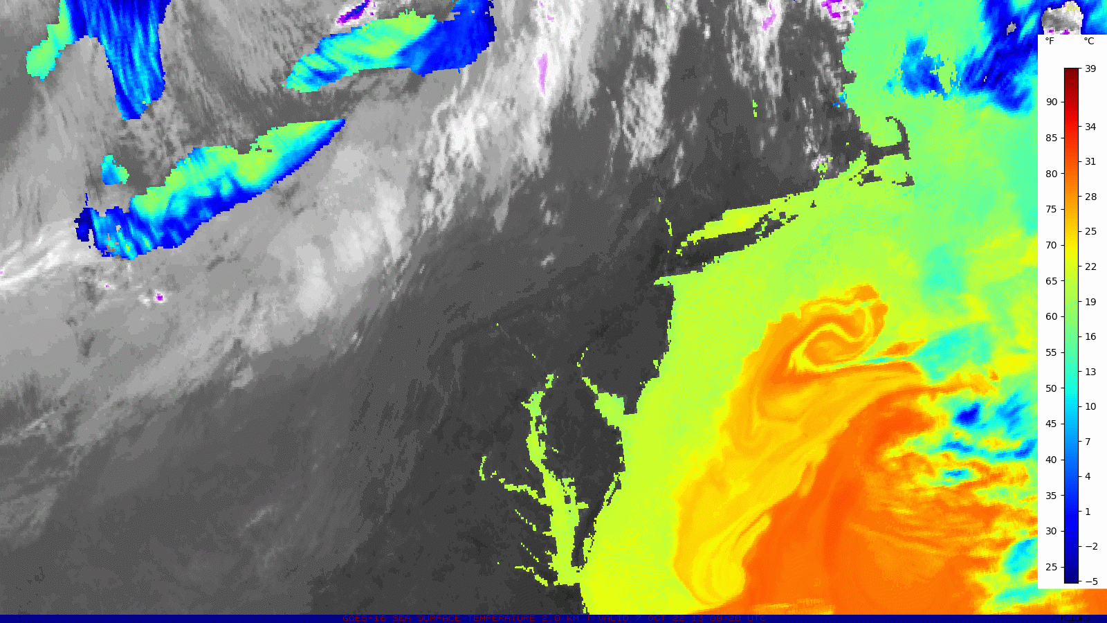
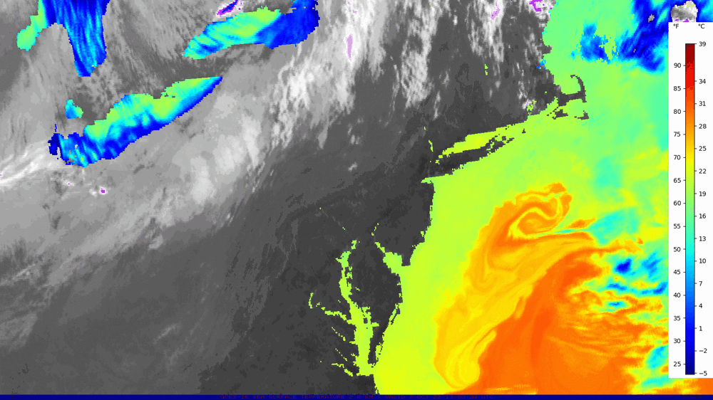
Water temps are in the mid to upper 70's just offshore in an interesting eddy that looks to be feeding off of the Gulf stream.
-
It was a significant short lived dry spell here, and perhaps one of the most significant for how little rain fell here, and the data backs this up. Reservoirs never got down too low because those areas saw more rain. I don't mind a dry period to even things out. I don't worry too much about a lawn, but many trees here were stressed from the drought. When the trees become stressed, it's clear indication of an intense dry spell.
-
ISP had the driest summer period (July 1st-August 31st) on record, even drier than the drought of the 60's. Obviously this was a shorter term drought, and if there was really anywhere that had real drought conditions, it was the south shore of LI. So yes, it was a significant drought here and the rain is needed here. Other places faired much better with the rain over the summer, and were only moderately dry. No one should ever compare a drought in the northeast to a drought out west, they are two completely different climates.
-
Dumping again!
-
Very heavy rain, had some gusty winds too