mitchnick
Members-
Posts
28,595 -
Joined
Content Type
Profiles
Blogs
Forums
American Weather
Media Demo
Store
Gallery
Everything posted by mitchnick
-
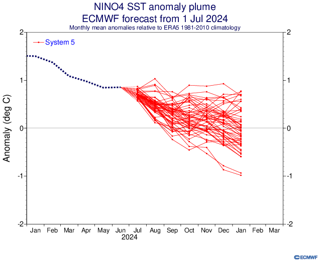
That map would constitute a La Nada with BN ssta only at -.2 to -.5, and it's not even Enso 3.4. That said, it's a fall map, so that's why I used the plumes that go into 2025.
-
-
No doubt the atmosphere is in a Nina state, but the MJO forcing is weak as reflected in the RMM plot COD. But despite the Nina state, the ssta haven't responded as of yet as most modeling predicted. So the question in my mind is "why not?" My wag is the lack of a strong, coherent MJO to support it. With modeling weakening the strength of the Nina vs. earlier runs, that suggests to me MJO forcing remains weak through the fall into winter. If that's the case, how does that change the picture, if at all, for winter in the east? The rest of all this Niña, PDO, etc. talk means nothing to me if it has nothing to do with winter! That's as far as my scientific curiosity goes to be honest. Lol
-
Measley .12" this morning.
- 6,666 replies
-
.2" yesterday with a rogue cluster headed for me now. Probably went thru Bubbler digs already.
- 6,666 replies
-
Thanks Larry! But looking at the MJO progs this morning, you may want to wait because continued hibernation in the COD looks favored for most of July too.
-
Saying the Wheeler plots are noisy (which means something different to everyone) doesn't mean the MJO hasn't been stuck in the COD, because it has. Nothing to dispute there. Bluewave's map is a day 7 forecast that may or may not be right, and NOT actual VP anomalies. That said, to me, there's a bit of a disconnect between VP anomalies and the lack of an active MJO/-PDO as I would have thought we would be seeing action in 4-6 on RMM plots. Maybe that'll change, but it makes me wonder if something else is going on.
-
Rn+ imby now.
- 6,666 replies
-
- 1
-

-
Down in Martinsburg WV seeing how the other half lives and I saw the best virga I've ever seen. Unfortunately, I was driving, so no pics. Then I drove through it and that was one of the most intense, compact T-storms I've driven through. This place reminds me of Hanover actually with its restaurants and shopping.
- 6,666 replies
-
Well, I'm not so sure about your MJO 4-6 prediction. It's been stuck in the COD for a long stretch and the more reliable modeling has it visiting 4-6 briefly before hibernating back into the COD. It's early, I know, but this has been an uncharacteristically long stretch in the COD with more time in it to come, so nothing's locked in yet imho.
-
The question becomes if the ONI stays weakish and the warmth in Enso 4 persists thru fall into winter while holding on to a Niña atmosphere, what will that mean for winter in the east? I don't know, but if the juice out west in the equatorial Pac holds, it has got to be better news than a traditional Modoki mod-strong Nina imh wag.
-
Agree. I am not yet convinced this winter north of 40N is shot. Further south gets tougher with every mile you go. But all Niñas have periods cold enough to snow, and the backing off of the Niña's strength by Cansips and the Cfs2 have come with colder temps. Still too early to say anything is a lock, but that's not to say a decent winter won't be a struggle.
-
I don't know if anyone took a look at the Cansips temps for Dec-Mar, but it's pretty darn cold up north. Caveats are that it's quite a change from last month's run and the 500mb anomalies are suggestive of something warmer.
-
It's in on Tropical Tidbits. Niña is weaker than last month. December the coldest month. https://www.tropicaltidbits.com/analysis/models/?model=cansips®ion=global&pkg=ssta_noice&runtime=2024070100&fh=5
-
Decent breeze out there with nice gusts as well. If only it was September.
- 6,666 replies
-
Put it back in.
- 6,666 replies
-
1.6" on the dot for the day/overnight. Pretty soupy feeling out there this morning.
- 6,666 replies
-
Torrential rain now but no wind of consequence thankfully.
- 6,666 replies
-
Thunder has begun.
- 6,666 replies
-
I think I'll escape any torrential stuff, but that stuff developing in the WV panhandle looks aimed right at me for now. Already lightening up some.
- 6,666 replies
-
- 1
-

-
Rain has begun and in 2 minutes borders on heavy. Surprisingly, no thunder yet.
- 6,666 replies
-
I'm on the edge of being clobbered or -rn. Should know in minutes.
- 6,666 replies
-
- 1
-

-
Tornado warning down at least. Only severe T Storm warning. Not great, but better than a tornado.
- 6,666 replies
-
Agree 100%. Hurricanes, tornadoes, and strong winds aren't for me.
- 6,666 replies
-
- 1
-

-
Looking quite nasty to my north. I don't like how the highest returns seem to be drifting south instead of the typical NE path.
- 6,666 replies

