

Heisy
-
Posts
8,369 -
Joined
-
Last visited
Content Type
Profiles
Blogs
Forums
American Weather
Media Demo
Store
Gallery
Posts posted by Heisy
-
-
Gfs vs 12z euro, still way different. Not encouraged that the cmc and icon look more like the GFS. Maybe the euro caves tonight?

.-
 1
1
-
-
Remember it could always be worst, check out the difference on the snow map for this event just 3 days out lol


. -
Early on, for better or worse there gonna be some changes on the GFS

.-
1
-
-
18z control is kind of odd at end of run. Just posting cause it tends to follow OP pretty closely and im bored.
Trough is really positively tilted. It almost looks like it was gonna dig and close off at the back end of the trough, which would have maybe allowed the front to clear first. Almost anafrontal…
Here is 18z eps as well

. -
My theory holds, those two pieces I mentioned were farther apart, hence a worst “snow” run. The runs that phases those waves quicker (like 00z euro) allowed spacing between the tpv and main shortwave and end better for us
. -
18z gfs Gfs vs euro around day 5, a lot to iron out

. -
One minor detail I noticed. I’m a sicko and like to compare “good” outcome runs “bad” outcome runs for snow. Today what I noticed is that the model runs that are better for us tend to have these two shortwaves phasing better. The farther apart these two the worst the outcome ends up being for our region fwiw.

. -
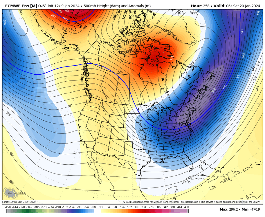
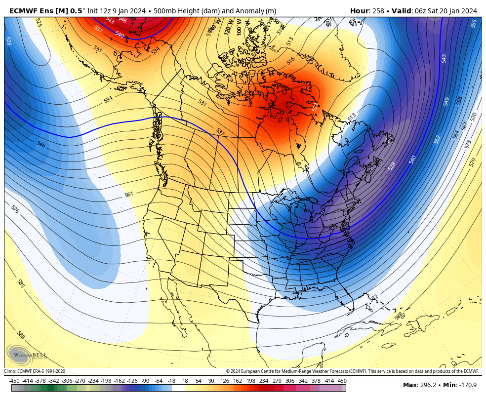
Actually Check that Brooklyn, I didn’t really do a deep dive beyond the 20th yet. On second look, wow. Stealing some of this from Brian on our forum… This isn’t an Atlantic blocking pattern, but -EPO, Cold air available. Split flow. Cold air gradient where we want it to be I bet anomalies are BN for temps


.-
1
-
 1
1
-
-
EPS has nothing for this timeframe today
Yea I think there mores of northern stream redeveloper threat around the 20th. Eps not really on that today, but GEFS was…
.-
1
-
-
here's the big dog window... decaying block, 50/50, and +PNA. just need a potent wave to amplify in the flow
It does look at the moment that there might be a pattern relaxation beyond the 22-23rd. Hopefully we’re able to take advantage during these two time frames
.-
1
-
-
Not sure anyone noticed, but last nights euro and todays had freezing rain for our regions. Guess the cold dome is strong enough


.-
1
-
 1
1
-
-
Only thing I’m not happy about right now is it does seem like the models are sending us the faint signal they like C PA up thru interior NE. Ignore the amount, just the placement.


.-
1
-
-
not really... or are you going to make the same mistake as many did with the last "threat". The 50/50 moved out too soon, there is NOTHING to stop the mid level southerly flow, the low tracks a little too close given those first 2 things...the exact solution the euro is showing here would NOT end the way you want it too, it would trend the same exact way the last how many of these threats that looked good if you only pay attention to a clow snow map did.
But this one has more potential to trend better given some of the other details here. There is more cold around. There is a 50/50 which is a new feature actually and if it continues to trend stronger could change this equation. There is a lot of stream interaction that could change the equation. The last event was much more simple and locked into a general progression at range than this one is. But this run exactly as is was not what I want the final solution to be or the snow will end up NW of us. We could get a nastier ice solution though with more cold around this time from that kind of progression.
Exactly, this isn’t a snowstorm without that 50/50 trending in better spot/stronger. Unless the main wave ends up being really really flat and we just get snow showers/light snow. Any deep trough with that TPV position neeeds a 50/50.
. -
Sounds like 12z euro is the most amped of the 3 models this run.
I noticed you tagged me on your question as to why we get a perfect pac and atlantic and the trough dumps SW and we get a SE ridge. I know you’re looking for an answer, but all I have to say is that I don’t know. I don’t have any answers for that.
This storm relies a lot on what happens to that streamer around the 14th. It ends up turning into our 50/50. We need that to trend stronger
. -
Can see it even better on the OP. Piece of the TPV pinched off into a 50/50. This was critical. See that trend continue at 12z? Woof

.-
1
-
-
I know I’ll sound like a weenie, but if we see this trend continue in 50/50 land (look at the improvement in Lower heights in this area 00z eps vs 12z ) this event has historic potential with the amount of energy diving SE. if you get a mechanism to hold down the LP off the coast wow…

.-
5
-
1
-
-
Gfs trended to euro. Eps looks good.
If we can get a piece of the TPV to break off into 50/50 land and see that trend progress the 16-17th event could be a huge one.
.-
1
-
-
Remember the days when we'd rejoice at the Euro having it and not worry about the GFS? And now it's the other way around?
What a time to be alive. This should be a morale booster for the forum for like 12 hours.
The trend this year seems to be really good 00z runs and horrid 12z runs. Man I really hope we see that trend at 50/50 as we progress next few days
.-
1
-
-
Euro loves to give HECS when everyone is sleeping


.-
5
-
1
-
-
I need to change my pants, time for bed

.-
3
-
-
WTH is it trying to do here lol…
Looks like a 1960s snow map
See how we got some tpv energy left over in 50/50 lane, that saved us
. -
Maybe I got a little too excited, HECs for interior, solid for us, just a little flatter with slightly better tpv position and we are in line
.-
 1
1
-
-
Euro about to be a HECS I think
.-
1
-
1
-
-
18z control looks like last nights 00z thru 144. Op and control mirror each other for the most part. This could bode well for 00z…


.-
12
-
2
-
Jan Medium/Long Range Disco 2: Total Obliteration is Coming
in Mid Atlantic
Posted
The 18z eps didn’t look like it trended the right way with the potential 50/50 so my hopes aren’t that high, but I’m with you. Buy me a window seat
.