madwx
-
Posts
2,303 -
Joined
-
Last visited
Content Type
Profiles
Blogs
Forums
American Weather
Media Demo
Store
Gallery
Everything posted by madwx
-
I’ve never seen a more misleading dark blue on a temp scale
-

Mid-week potential of something somewhere
madwx replied to Chicago Storm's topic in Lakes/Ohio Valley
Yeah the upper level evolution of the Euro and some of its ensembles that I’ve looked at seem to make more physical sense than what the gfs is showing -
Mid-week potential of something somewhere
madwx replied to Chicago Storm's topic in Lakes/Ohio Valley
This is a complicated pattern and there are numerous ways this can evolve. Depending on how strong the first and second waves are and the timing between the two. 6z GFS is probably the upper limit here with the second wave coming in further north and deepening the original low substantially. I also wouldn’t mind a better hit further south since we’ve gotten our fair share of snow here and the weenies down south could use a nice storm -
Mid-week potential of something somewhere
madwx replied to Chicago Storm's topic in Lakes/Ohio Valley
A bit off topic but this vortex isn’t going anywhere any time soon. A good analog is 1997 and the stratospheric final warming didn’t occur until April 30. -
Mid-week potential of something somewhere
madwx replied to Chicago Storm's topic in Lakes/Ohio Valley
Will enjoy the cirrostratus canopy -
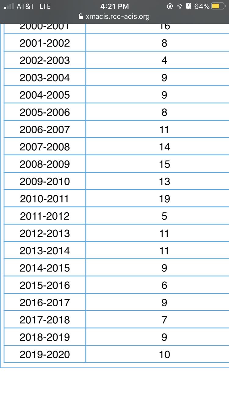
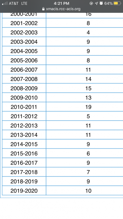
Here’s the max depth of the past 13 or so winters. Can really see the hot streak we had from 2007-2011
-
In Dec 2012 the depth got to 11", deepest last year was 9" in early February
-
13” snow depth in Madison this morning. Deepest snow cover since GHD1
-
In addition we have a chance at a record low temp tomorrow morning. The record low for the 14th is a relatively mild -13 which is only 2 degrees below the point forecast.
-
While it looks certain to go below 0 tonight in Madison, with no other below 0 temps on the horizon and time running out quickly for them to occur there is another record we could be trying to attain or tie, least number of below zero days in a year. Currently the record holder is 1877-78 with 1 but I am always skeptical of temperature records back then since measurements were only taken 3 times a day. A more modern record is 1997-98 with 2 days. Unfortunately it looks like it will go below 0 before midnight, which means we will get hit with 2 days below 0, even though it's occurring for only 1 night.
-
Madison hasn't had a temp below 0 yet. The lowest so far is 0 set on January 19th. The standing record for warmest minimum temp of a winter so far is -4 set in 1930-31. Will be interesting to see how low we can go at the end of the week. Current point has -1.
-
No in fact people have tried to argue the opposite, that solar minimums lead to more high latitude blocking and therefore PV disruptions.
-
What have your snow out days been the last few springs? Also I wonder how much liquid content is in that snow
-
37.4" of snow here on the season. 8.1" in Oct, 7.6" in Nov, 2.9" in Dec and 18.8" in Jan.
-
record high broken both at 11 am at MSN and MKE. Up to 50 here with a couple more hours to increase the temp. the snowpack will survive this but it's definitely taking a hit
-
Record high of 47 in Madison about to go down as it was already 46 as of 9 am. Today is tied with 3 other days having the coldest record high temp so it was one of the easiest to break
-
Luckily we have a few (possibly) silver linings: 1) its not guaranteed yet that a SSW will occur, only half of the GEFS have a warming occurring in the next 2 weeks 2) Not all SSW are the same and depending on how the vortex gets split/the alignment of the blocking we may not get brutal cold 3) By the second half of May, when prime storm chase season is occurring, the weather patterns are not really connected to any SSW occurring in Feb/Mar
-
Long range models indicating an increased chance of a SSW during the month of February. Defintely not set in stone but slightly concerning for people hoping for a warm early spring.
-
4:22 for the earliest sunset here which can be brutal