

Carvers Gap
-
Posts
14,245 -
Joined
-
Last visited
Content Type
Profiles
Blogs
Forums
American Weather
Media Demo
Store
Gallery
Posts posted by Carvers Gap
-
-
Most short range models show a lull between the rain and snow for the northeast Valley. The snow in NE TN/SW VA happens after the energy in the vortex dives into the trough as the slp develops along the coast. It deepens that coastal low and snow builds into that region w energy diving into the trough. Looks like it tomorrow morning that the snow (if it happens) begins for lower elevations. The snow in Wytheville is early if one looks at the 18z NAM.
-
 1
1
-
-
21 minutes ago, Olhausen said:
It started snowing at 4:30 and heavy at times but the temp is only 34 so no accumulation. I'm right on the edge of the winter weather advisory so it'll be a close call on weather I get any accumulation tonight. Either way just seeing heavy snow fall from the sky is a huge victory this time of year.
Awesome! Anytime we can get snow falling at this elevation on March 20...bonus!
-
Pretty wintry looking forecast period for mid-late March. KTRI...
-
Looks like lightning has been observed at KTRI and Middlesboro. Crossville is sitting at 41.
-
1
-
-
1 minute ago, John1122 said:
Temp has fallen to 43 degrees, stiff northwest wind. Not checked the temp at Clarksville, but snow appears to have started there.
That could be really good for you all.
-
1
-
-
Looking at snow on RadarScope just west of Nashville. You all seeing any out that way?
-
48 minutes ago, BlunderStorm said:
Yep you weren't kidding Carver this run of the NAM
is certified by the Kingsport Snow Hole of Approval...

Kingsport is like the Chattanooga of this latitude. We get more snow because of our position in relation to the Atlantic and we are just close enough to get upslope snow. It also gets much colder up here than compared to southern areas of the forum. But where we are in the Valley provides exponential opportunities for lesser amounts - rain/snow shadow city. We are like a decent mid-major basketball team in a Power 5 conference up here. We get on a good run from time to time...but the blue bloods usually win. There are events where I am only a ten minute drive from decent snow. Roan mountain saves the day usually...we drive there when we get whiffed over here. Takes about an hour, but well worth it. Plus, when I get home I don't have to shovel.
-
 2
2
-
-
I should add that the 12kNAM will likely verify as the snow hole is right over my local, and Chattanooga is also without snow. I have seen this movie before.
Any snow is bonus snow at this point...flurries, snow showers, or for a lucky few..accumulation. When I lived in JC for a few years, March seemed to always hold a few surprises.
-
2
-
-
The 12z 12kNAM also shows a shift northward w the snow shield which is a very normal trend with spring storms. Still, plenty to watch. Really, I am hoping the mountains see something as I am willing and able to travel if the roads are clear...and of course if there is snow in them thar hills.
-
1
-
-
Just flipped through he overnight model suite and morning 6z run. I have been watching this for some time. Just have not written much as I think most were getting weary of the snow talk during what should be spring. (If you want to see a broken record....just go look at the BN temps on the Weeklies. On the bright side, it does finally show seasonal temps by late April.) March snows are notorious for surprises and difficult in forecasting. I generally just look at it like this...mountains (as usual) get more but the discrepancy is usually much more. The Valley is a total crap shoot - as there are multiple drivers for snow there but elevation is the issue and time of day. This system is tricky. Many of the short range models have a slp developing in the lee of the Apps which is partly energy transfer and partly just a vortex rotating into the area. Big takeaway is decent amount of energy rotating through as it cools off. MRX has a great write-up this AM BTW. I wasn't going to include it, because it was so long...but it is truly a good write-up.
<Begin MRX quote>
The cold air behind the frontal passage will allow the rain
showers to change to snow showers across the higher terrain first
this evening, and then into the Plateau overnight. For the valleys
of southwest Virginia and northeast Tennessee and gradual change
over to snow showers is expected early Wednesday morning.

Due to low-level instability, orographic lift, and deformation
zone wrapping around upper low, a prolonged period of snow showers
are expected across the area through Wednesday evening. Snow
accumulations will be elevation dependent given the relatively
warm ground and strong ultra-violet radiation melting snowfall.

Have issued a winter storm warning for the higher elevations of
southwest Virginia, such as High Knob, and the far eastern
Tennessee Mountains. Places like the higher terrain of the Smokys
will likely see the greatest snow accumulations.

Light snow accumulations are also possible over the lower
elevations of southwest Virginia and northern Plateau. May need to
issue a winter weather advisory there later this morning.

Besides the snow, freezing temperatures are expected area-wide for
Wednesday night/Thursday morning. A freeze watch will likely be
issued later today.

.Long Term (Thursday through Monday)...
Temperatures will remain around 10 degrees below normal with
northerly/northwesterly flow bringing in colder and drier air. After
a brief break from precipitation chances during the day on Thursday,
chances ramp back up Thursday evening/night. A shortwave will move
in from the northwest and bring out next chance at precipitation.
With the temperatures expected to get near or just below freezing on
Thursday night/Friday morning we can`t rule out the possibility of
additional winter weather. Right now the best chances look to be in
the higher terrain and NE Tennessee and SW Virginia...But as usual
with these events a lot will depend on the temperatures overnight,
so potential snowfall amounts at this time are a bit tricky. But
currently widespread heavy snowfall is generally not expected in our
forecast area.
<End MRX quote>
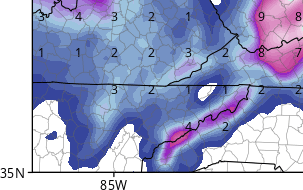
Here is the Euro map from 0z and it looks reasonable if maybe not slightly too hefty for the Valleys and underdone in the mountains. That is to be expected by a global model.

-
3
-
-
@1234snow ...like clockwork.
Thunder in the mountains during winter -> snow within two weeks. I know...I know...it is spring, but still funny nonetheless. Winter storm watches up in the mountains of North Carolina and SW VA. WWA for those in SE KY.
.LONG TERM (Tuesday night through Monday)...We start the period with
an area of low pressure swinging across the forecast area with
ongoing light rain showers in place. As the low pulls east Tuesday
night, colder air will advect into the region with stout nw flow
behind the low. As temperatures drop through the night, rain will
transition over to snow. The highest elevations will see snow as
early as 00Z Wednesday. The snow line will quickly work its way down
in elevation and areas around 3000/4000 feet should be seeing snow
by roughly 03z. Depending on which model you look at, snow could
start as early as 09Z for some valley locations and by 12z at the
latest. Depending on how quickly the rain transitions over to snow
in valley locations will determine the amount of accumulation, if
any. As of now it looks like our favored upslope terrain, above 5000
feet, could see 2 to 4 inches with up to 6 across areas such as
Mount LeConte, Sam`s Gap, and Roan Mountain. Areas between 2000 and
4000 feet 1 to 3 inches. Portions of the northern plateau, northeast
TN, and southwest VA up to an inch in some valley locations. Where a
dusting is possible across the central valley. We will continue to
watch this system closely, especially as soon as we get past our
severe weather event moving through tonight. A mountain zone winter
weather advisory is likely with the next forecast update tomorrow
morning. Light snow showers still in place Wednesday morning but
tapering off by late morning for the valley. Light snow showers will
linger on and off across the high terrain through the day. Highs on
Wednesday are the coldest of the period with highs in the upper 30s
to mid 40s. A few light snow showers could even linger into
Wednesday night due to the upslope flow. Lows overnight will be in
the mid to upper 20s for most.
-
2
-
-
13 hours ago, 1234snow said:
CMC and ICON bury the east coast while the GFS is a whiff for those folks. 12k NAM buries parts of VA east of Roanoke with a foot plus. For us it will be tough to get accumulating snow outside of the higher elevations. Unless the vort can close off and suck the cold air in faster.
Your saying is snow just a few days after thunder and lighting right? LolHa! Well, technically I am not sure that applies during spring....but does anyone have an accumulation map for the 12z Euro for the mid-late week system?
-
Interesting and volatile week of weather coming up per the ICON, GFS, and CMC at 0z...The strat warm and subsequent block continue to wreck havoc on spring.
-
Weeklies update....Keep in mind this is not a "winter season" update...but, man, it is cold relative to averages considering these are mean departures for normals. Temps are BN for most of the 6.5 week forecast...This current week and a timeframe during wks 4-5 depict seasonal to warm temps which eventually gets pushed back. Precip is BN for the southern areas of the forum and normal for the northern areas...but a generally BN signal overall for precip. So, some of that does not jive...normally for a cold spring, we see plentiful cold rains. Time will tell. The potential for a change in ENSO may be driving some of this. Have to think during those brief time frames where it warms up...sever could be an issue.
....This week and next is heaven for basketball fans. Some great games yesterday. More on tap today!
edit: Typos fixed.
-
1
-
-
........My mind says that last third of March is just a "no go"...but the overnight runs at 0z and 6z at least have my passing attention. So, proceed at your own risk from this point forward in this post. The event looks a bit too complex on the 21st of next week, and complex can be a pain even during the heart of winter....but most global operationals are showing some variation of the same thing. SLP crosses the TN Valley and a slp forms in the lee of the Apps or Piedmont and then slows over the Chesapeake area. I can definitely see a scenario of cold chasing rain...but that slp forming as one exits has been depicted for several runs. To me, spacing seems to be an issue, but there could also be an issue of the models not knowing which piece of energy to accentuate and/or have difficulty w those interactions once formed. Again, NE TN and SW VA seem to be in an area that could possible see winter precip....at this point ANY snow is bonus, even flurries. I think this is a very good write-up by MRX.
This Spring type weather
will give way to a colder regime to end the long term period as two
or three short wave features dive into the back side of an Eastern
United States long wave trough resulting in a rather amplified
pattern Wednesday and Thursday. Model solutions indicate these short
wave systems may have enough moisture for a chance of rain showers
mainly on Wednesday with decreasing probability Wednesday night into
Thursday. The temperature profile could be cold enough for the
possibility of some snow showers in the higher terrain during this
period, and maybe even in valley locations across Southwest Virginia
and Northeast Tennessee as the system gradually moves away to the
east Wednesday night and Thursday morning. Forecast highs will be
near normal for mid March early in the long term, but will be a good
ten degrees below normal during the end of the period.
........Now to the near term. I thought the disco from MRX regarding severe(prior to the event above) was also interesting regarding Sat night. I am no fan of large hail which have been a big problem for those of us in NE TN during the past couple of decades. These comments preceded the comments noted above
or Saturday...Warm front will continue to lift northeast across
the regon with showers and elevated thunderstorms likely for the
first half of the day. For the afternoon, the central and southern
valley will likely have a lull in the convection as the lift moves
north. However, as the upper trough moves toward the east Ohio and
northern Tennessee Valleys late afternoon and evening, scattered
showers and storms will redevelop.

The NAM, GFS, and ECMWF all differ on the amount of low-level
moisture available during the afternoon. Will follow the more
moist NAM/ECMWF solutions for now and expect scattered to broken
convection to develop.

Model soundings show the potential of large hail and damaging
winds. MLCAPES of 1000-1500 J/kg, Hail CAPES of 300-600 J/Kg,
lapse rates near 7 C/km, and WBZ Heights near 7kft support large
hail. The 0-6km shear of 60kts also support rotating storms with
more sustain updrafts. SHIP values between 1 and 1.5.

As for the convective damaging winds, melting hail, plenty of dry
mid-level entrainment and mid-level winds of 30-40kts supports
potential of damaging winds.

The potential strong convection will emain during the evening
hours with showers diminishing after midnight.
-
1
-
-
4 hours ago, John1122 said:
Kudos to the RGEM/HRRR they nailed the 1-2 inch snow amounts in my area when the NAM was only showing them in NETN/SWVA. The RGEM is very good with northern stream/clipper type disturbances.
I agree. It did a great job. Has been pretty good over the past week w a few expected hiccups.
Edit: MRX did a great job as well w their disco Monday evening.
-
1
-
-
Winter Wx Advisory posted for SW VA tonight.
-
1
-
-
Great discussion everyone and thanks.  Great read.

MRX evening disco snippet...

LONG TERM...(Tuesday night through Monday)...A vort max rotating
around a closed upper low will drop southward into our northern
sections on Tuesday night, bringing steep lapse rates and a NW
flow that will generate scattered to numerous snow showers in SW
VA and NE TN. Saturation in the dendrite growth zone and cold
temps aloft will begin in our area around 03Z Wed and continue
until around 15Z Wed. With surface temps in the 20s, 1-2 inches of
accumulation may be possible in the mountains of TN and SW VA,
with under an inch expected in lower elevations of NE TN and SW
VA. Highs on Wednesday will be well below normal, only in the
upper 30s and 40s.
-
I should add that the 12z EPS now has the trough back in the East for days 10-15 w warmth along the Gulf.
-
It is 41 in Kingsport with a windchill of 31. Wind chills are forecast tonight to be in the upper teens to lower 20s. Snow advisories are still posted for mountain communities. Still feels like winter, but spring temps are back in the forecast for this weekend.
-
Glad that you started this thread. Weeklies will roll tonight. I will add a spring update unless @nrgjeff updates first. My Weeklies spring updates are not "winter focused" though there certainly could be some snow for the mountains. So, when I mention cold it is not "winter cold" but just against the norms. Like @John1122, I think we are cold for a bit. I wonder how the transition to a neutral ENSO state will impact things. The models are hinting at some warmth building from the south/southwest. To close out the winter thread, I mentioned that it will be interesting to see if the Greenland block re-establishes(not that it really leaves) and if the building warmth in the aforementioned areas can "win" the battle. By warmth, I mean AN temps. Obviously it is spring, and warmth of a seasonal variety will win at some point.
-
1
-
-
2 hours ago, Windspeed said:
Some organizing supercells moving towards north-central Alabama. Weak rotation but nothing yet tornadic.

That does not look good. Any updates on those cells and what happened on the ground?
-
6 hours ago, AfewUniversesBelowNormal said:
Don't expect it to go El Nino anytime soon.. subsurface for this late in the Winter may even support a Nina rebound in the Summer if it doesn't persist at the surface
When is the last time that we had three consecutive La Nina winters?
-
9 hours ago, Holston_River_Rambler said:
So, to be fair, I thought it might also be useful to look at big -NAOs (-1.0 or higher) that failed to produce anything in March. I went through the NAO data on ftp://ftp.cpc.ncep.noaa.gov/cwlinks/norm.daily.nao.index.b500101.current.ascii and searched for values or -1.0 or higher. Below are my results:
-1 or higher
3-10-51
3-28-51
3-27-52
3-12-54
3-6-58/ 3-21-58
3-1-62 (almost the whole month lower than -1.0)
3-6-69
3-30-70
3-30-71
3-28-75
3-24-77
3-18-79
3-20-80
3-18-81
3-26-81
3-1-2001
3-11-2005
3-1-06
3-10-2010
3-24-2011
3-21-2013
-2 or higher
2-13-78 (only one that was close to the dates we're looking for; there were some April ones, but that'e getting pretty late in the season)
-3 or higher
None in the winter
If John is willing, I thought it might be useful to look at his family records for a couple weeks after these dates to see if there were storms. If no storm, then I would like to build a composite for those dates as well so we can see what sort of pattern with a -NAO might not produce winter weather.
But keep in mind some of those are very good years, we just missed by chance. '62 is the benchmark year for what a -NAO can do. We just missed by chance that year. Pretty sure not all areas missed on snow, especially far eastern areas and NE TN during 62. Interesting discussion for sure. Again, thanks a ton for everyone's hard work!

-
1
-
Spring/Summer 2018 Mid to Long Term Discussion.
in Tennessee Valley
Posted
This "should"(not sure what they have at the airport) mark the sixth day during March where KTRI will measure a trace or more of snow.