

Carvers Gap
-
Posts
14,245 -
Joined
-
Last visited
Content Type
Profiles
Blogs
Forums
American Weather
Media Demo
Store
Gallery
Posts posted by Carvers Gap
-
-
2 hours ago, Holston_River_Rambler said:
I'll also add this. As disheartening as it is, after looking at the NAO data today and having just looked at dates for big storms over the past few days, I think we want more mediocre NAO values. Some of the big dates had -NAOs, but most were under -1.0. But I think we've all agreed that it is as the big block decays that we get our chance(s).
On the other hand there were no -NAOs below 3.0 in the winter in the period of record and I think only two on record at all, for any month. If this one goes that low who's to say what the outcome is.
I also don't like the look of the little ridge poking up on that first image. Looks familiar to what is being modeled with this persistent mid continent ridge that connects to that NAO.
Oh, we want a locked in -NAO in NE TN, unless you are in a place for upslope snow. Otherwise, we need Miller As on my side of the Valley. -NAOs slow the pattern enough to produce them. One thing to keep in mind is that the Plateau westward usually requires a different look and they do indeed need the Pacific to cooperate. We need the Atlantic over here. Crazy, huh? The mediocre values IMO are because the NAO begins to decay as you mention. Most storms occur as the values begin to rise after bottoming out like your original maps. It has to be strong before good patterns emerge for us. The Weeklies have the NAO barely hitting neutral during the second half of March and early April. -NAOs are more important for E TN because we can actually catch the fetch off the Atlantic for big coastal...middle and west usually do not. Great work!
-
 1
1
-
-
14 hours ago, Holston_River_Rambler said:
Alright, I have the first one. Below are the dates I picked. I started with the biggest ones on John's list and added ones I found in the KU book this AM. I have figured out how to work the system better and found the correct link (in the links thread) to the daily 20th century reanalysis data, so am happy to plug any combination in y'all want!
3-2-1942
3-1-27
3-17-35
3-12-93
3-24-40
3-1-54
3-2-60
3-9-60
3-14-60
3-3-80
3-7-96
3-6-1992

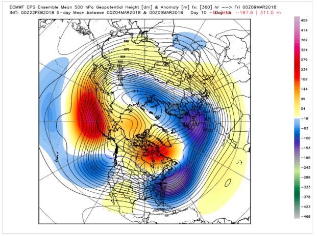
Here is the d10-15 mean on the 0z EPS. For comparison...not exact but interesting.
-
Also, notice that area of BN heights just east of HI...that is also a nice marker.
-
Great work! Nice information and graphic. Looks to me like a -EPO ridge w some blocking over the Davis Straits is key...AND that the storms don't necessarily happen until the block matures and erodes just a bit.
-
1
-
-
John that is an awesome list, man. I just wanted to add that. That is just one of the many things that makes our forum awesome.
-
1 hour ago, Holston_River_Rambler said:
So that analogue website has a limited number of data entry points, so I have to pick a few from John's list. I thought maybe try Miller A and B events first, since they would have the potential to impact more of us than NW flows, but thought I'd see what y'all thought.
Use the big storms IMHO. Looking good.
-
 1
1
-
-
12 hours ago, AfewUniversesBelowNormal said:
It's strengthening a little bit, a lot versus climatology for this time of year. In El Nino transition, it's usually a little different right now meaning this probably goes until April.. that's all
You know, I wonder how the -QBO is influenced during a transitional ENSO state. Usually it is money for cold in this area and is closely tied to high latitude blocking. I wonder if the -QBO is enhanced or muted during a transitional state?
-
1 minute ago, Holston_River_Rambler said:
One of my most distinct memories from that time and my entire youth (I was 10) was watching Johnny Wood on WCYB stand in front of a radar map, gesturing too a blob of precip in Texas and saying something like: "I know a lot of these seems to have missed us this year, but it doesn't look like this one is going to". Good times and thundersnow!
Great memory.
I was at UT. You know, the WATE guys sort of insinuate that they missed on snow totals....but they nailed that forecast from almost a week out. IMO, it was a real success of computer modeling. They may have missed on totals, but I remember waking up on Saturday knowing there was going to be a blizzard. They did really well.
I grew up watching Johnny. Always enjoyed his work. Some great old-school anchors from both Knoxville and TRI that I remember. He is one of them. I always enjoyed Bill Williams of WBIR as well...He did not do the weather, but just delivered the news very well.
-
1
-
-
Coming up on the 25th anniversary of the Blizzard of '93....Link to WATE anniversary coverage from yesterday. Hard to believe it has been that long ago.
-
1
-
-
Weathertree...I am seeing some hints of a Nino developing. Jeff mentioned there was some evidence that a developing Nino could reduce the severe season spring threats. As for next winter though, the models are generally really bad with ENSO IMO. I think they called for a weak Nino this winter and then backed off??? I think right now it will be tough to know the strength or placement of anomalies for next winter. Generally by early fall we start to get some idea what the ENSO will look like.
-
1
-
-
Great thread. One of my favorites. So are we looking at a La Nada w Nino tendencies for the summer? Would be fine by me!
-
1
-
-
I wonder if this moves towards a weak to moderate Nino by next fall. Way out there and ENSO predictions can be fickle.
-
8 hours ago, jaxjagman said:
Meant to post back sooner.When i get back from Chicago i will do this.But you need to help out this time as well with other posters here,this is really time consuming,and i know others can chime in which would benefit the thread as well.We have some good posters here now and it's growing.So everyone should chime in from time to time with thoughts
Will do.
-
Always an informative thread. We need the enso thread as well, Jax. It looks interesting over the next year or so.
-
Great stuff, everyone.
-
1 hour ago, dwagner88 said:

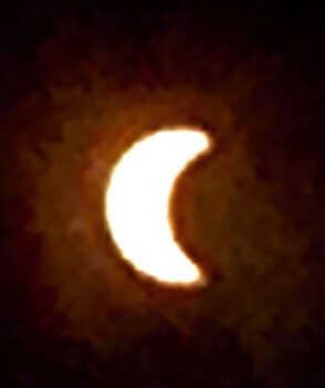
From Watts Bar lake this afternoon. What an amazing experience. I can't really put it into words. I believe Mercury is visible in this image to the left. This was taken on a Nikon DSLR.
Did you use a filter or filter on a computer? Great shot!
-
John and knoxtron, what did you all use to get those pics. Awesome.
-
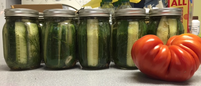
Refrigerator pickles. Aged them for two days on the counter and then refrigerated for two weeks. This pic is before the aging process. 15 pints of these... Also, that is an Italian canning tomato.
-
Awesome pics, you all.
-
Not the best. Can't wait to see some filtered shots. This is w an iphone w glasses over the lens. LOL.
-
2
-
-
-
4 hours ago, tnweathernut said:
only 2 pages per year, pretty crazy!
Tortoise thread....Slow and stead wins the race! Hey, it may get cloudy but at least we know w this event that it will 100% happen....and not have to follow 40 straight runs only to see it go OTS or to NC or to Ohio or just dissipate. LOL!!!!
-
Pretty awesome to follow a thread for two years and be almost there...
-
4
-
-
39 minutes ago, nrgjeff said:
Better than snow forecasts for sure! Even better than convection. Seriously, my main point was forecasting fair weather requires less precision than forecasting an exact storm track. However for an eclipse we need really good weather, so there are some nuances. Nashville is more optimistic this afternoon. Morristown already was this morning.
I do not plan on any serious photography. Goal is to remember the event as best I can without fiddling. Photos do not work due to such ranges of light within the corona. Memory experts also recommend looking around, not just staring at the corona. Change what we are looking at every several to 20-30 seconds. Check the rest of the sky and look at the horizons for the 360 sunrise/set effect. Of course return to the corona main show often. I can still remember the Aurora and comets decades ago, like last night, no photos. This is going to blow the doors off anything we have ever seen!
More tomorrow...
I will snap a few pics. Going to make an old shoe box viewer. Not sure I posted this, but I may have....we inadvertently took a pic of a partial eclipse while in Sanibel a few years back. The sunset was outstanding that evening. We forgot about the eclipse. Later, I saw an article about the eclipse. It jogged my memory. I hustled over to the computer to look at the pics...and there it was. Clear as day. What are the odds?
My wife is the family photographer by the way. I almost always work from memory. I would just like to see some experiences of others from the event. The zoom feature along s computer filters allowed a pretty clear look considering we were not trying to photograph it.


Historic Tennessee Valley Cold, Snow, and Ice Events
in Tennessee Valley
Posted
The odds of everything being exactly correct are very low. We can get snows during bad patterns and miss during good patterns. Many of the very big snows in the eastern Valley during March I am willing to bet occurred during -NAOs. That is unlikely to be as true for points to our west. But I do add again, rarely are things perfect. We don't have to have multiple things in our favor...just a few things that work really well such as a -NAO or +PNA and/or a broad, full latitude block which is my favorite. What we need is a general pattern look. Also, the -QBO is definitely correlated w -NAOs and very snowy winters in NE TN. The tricky thing about the QBO is there is a difference in QBO that has just turned negative and is falling and one that is rising though still negative. Off the top of my head, a -QBO that is rising near neutral can be very warm during winter...but double check that. The best QBO is one that drops during late fall or early winter like we had....ENSO is also a big factor which is currently in transition.