Mailman
-
Posts
1,653 -
Joined
-
Last visited
Content Type
Profiles
Blogs
Forums
American Weather
Media Demo
Store
Gallery
Everything posted by Mailman
-

Pittsburgh/Western PA WINTER ‘25/‘26
Mailman replied to Burghblizz's topic in Upstate New York/Pennsylvania
KEY MESSAGE 2... Potential increasing for an impactful snow/winter storm Saturday night through Sunday night- The latest trends in both operational and model ensembles indicate a northward shift to impactful snow. A deepening trough is progged to track SE from the northern Plains, as a southern stream trough advances across the SW CONUS. These systems are expected to phase across the Central CONUS on Sunday. At the same time, a surface low is progged to develop across the Gulf Coast region, with an inverted surface trough northward to the Upper Ohio Valley region. Snow should begin to overspread the region Saturday night as these systems approach. A coupled upper jet structure should also enhance ascent Sunday, with frontogenesis as far north as I-80. Saturation throughout a deep dendritic growth zone should lead to efficient snowfall on Sunday as well. Ensemble based probabilities of at least a 6-8 inch snowfall have increased to 70-80 percent across much of the forecast area. Current probabilities of a 10 inch or greater snowfall have increased to 50 percent as far north as Pittsburgh, with higher probabilities to the south. Given the shift in some of the operational models, would like to see later data to initialize a potential Winter Storm Watch. Have held off on issuance for now in coordination with surrounding National Weather Service offices. Will enhance the Hazardous Weather Outlook to indicate the increasing probability of an impactful snowfall. The heaviest snow should begin to taper off overnight Sunday night, through cold NW flow and the crossing parent upper trough could result in lingering snow into Monday. With the track of the low to the south, the Upper Ohio Valley region will be in the cold sector so no potential for mixed precip is expected. This incoming system has the likelihood for widespread impacts from a significant snowfall. Stay up to date on later updates and possible watches. -
Pittsburgh/Western PA WINTER ‘25/‘26
Mailman replied to Burghblizz's topic in Upstate New York/Pennsylvania
I said last night that I will go in with the mindset that I'll take a 6" snowfall and anything more is a bonus. -
Pittsburgh/Western PA WINTER ‘25/‘26
Mailman replied to Burghblizz's topic in Upstate New York/Pennsylvania
Yep, because if it's modeled close to the border, it'll make its way up my way. -
Pittsburgh/Western PA WINTER ‘25/‘26
Mailman replied to Burghblizz's topic in Upstate New York/Pennsylvania
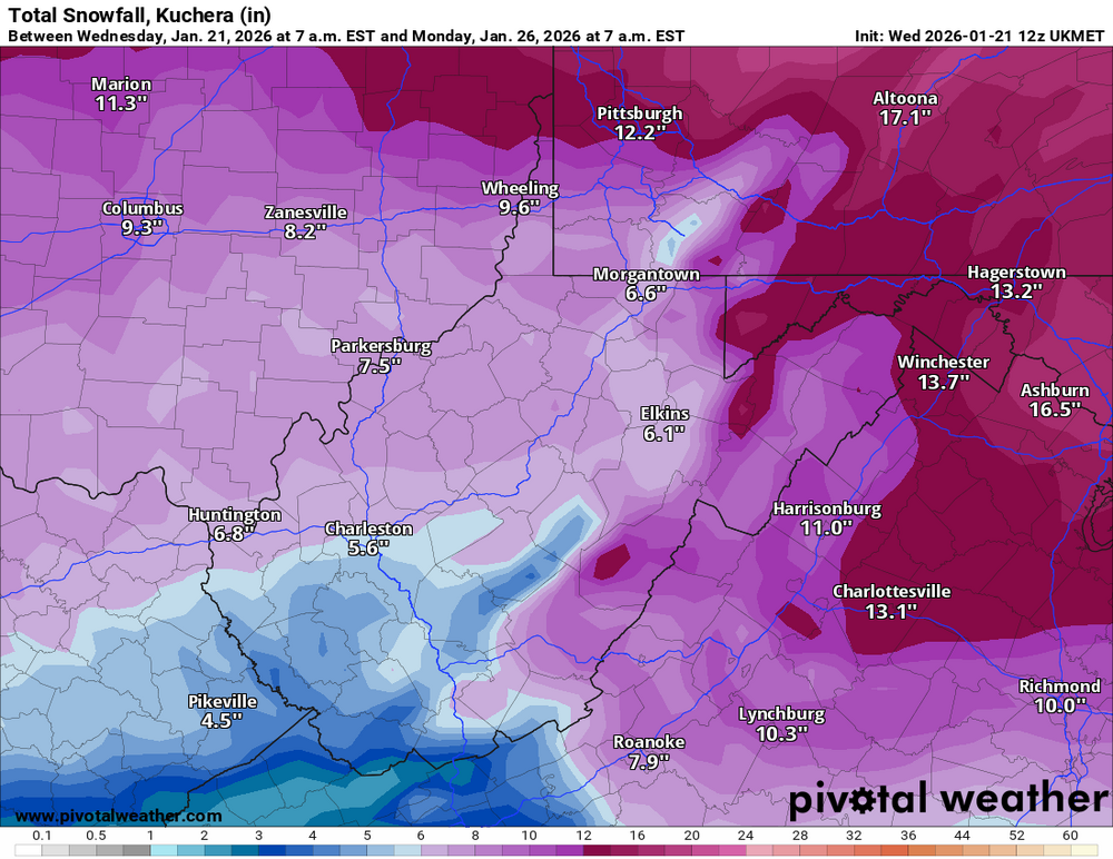
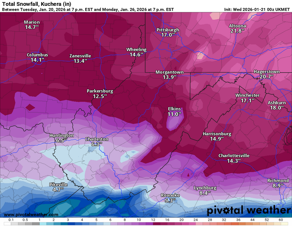
Seems Euro stays all snow from the PA/WV line northward. -
Pittsburgh/Western PA WINTER ‘25/‘26
Mailman replied to Burghblizz's topic in Upstate New York/Pennsylvania
-
Pittsburgh/Western PA WINTER ‘25/‘26
Mailman replied to Burghblizz's topic in Upstate New York/Pennsylvania
-
Pittsburgh/Western PA WINTER ‘25/‘26
Mailman replied to Burghblizz's topic in Upstate New York/Pennsylvania
Oh my. Here we go. -
Pittsburgh/Western PA WINTER ‘25/‘26
Mailman replied to Burghblizz's topic in Upstate New York/Pennsylvania
That'll work. Only 4-5 days to go. -
Pittsburgh/Western PA WINTER ‘25/‘26
Mailman replied to Burghblizz's topic in Upstate New York/Pennsylvania
Just a foot area-wide on the Canadian. -
Pittsburgh/Western PA WINTER ‘25/‘26
Mailman replied to Burghblizz's topic in Upstate New York/Pennsylvania
The ICON, for you know what and giggles.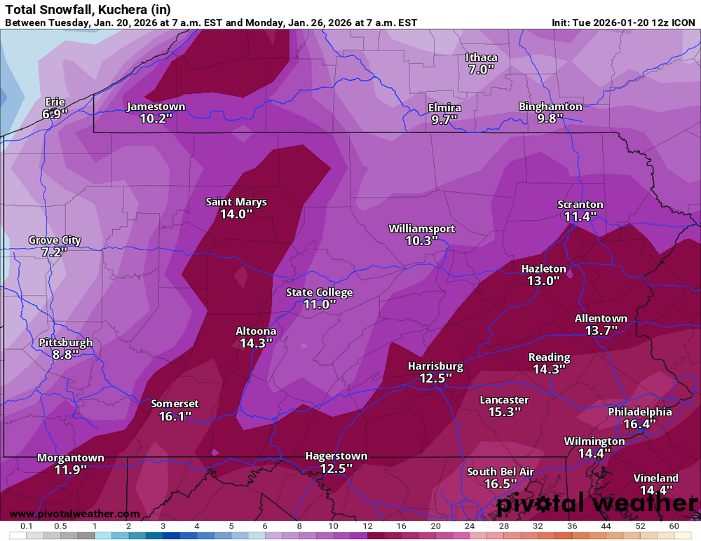
-
Pittsburgh/Western PA WINTER ‘25/‘26
Mailman replied to Burghblizz's topic in Upstate New York/Pennsylvania
Canadian is a real good hit area wide. -
Pittsburgh/Western PA WINTER ‘25/‘26
Mailman replied to Burghblizz's topic in Upstate New York/Pennsylvania
Don't wanna be in the bullseye 5 days out anyway. -
Pittsburgh/Western PA WINTER ‘25/‘26
Mailman replied to Burghblizz's topic in Upstate New York/Pennsylvania
Oh Canada. -
Pittsburgh/Western PA WINTER ‘25/‘26
Mailman replied to Burghblizz's topic in Upstate New York/Pennsylvania
Just came thru here. Was rippin' pretty good. No flashes, no rumbles, though. Guess I will go to sleep. -
Pittsburgh/Western PA WINTER ‘25/‘26
Mailman replied to Burghblizz's topic in Upstate New York/Pennsylvania
Feel honored to be in the year's first mesoscale discussion. -
Pittsburgh/Western PA WINTER ‘25/‘26
Mailman replied to Burghblizz's topic in Upstate New York/Pennsylvania
Thundersnow heading towards New Castle! -
Pittsburgh/Western PA WINTER ‘25/‘26
Mailman replied to Burghblizz's topic in Upstate New York/Pennsylvania
Didn't do squat down here today; however, i did have to venture to Johnstown this morning. It was rippin' good on 711 between Donegal and Ligonier this morning. -
Pittsburgh/Western PA WINTER ‘25/‘26
Mailman replied to Burghblizz's topic in Upstate New York/Pennsylvania
Some sort of wintry mix here. -
Pittsburgh/Western PA WINTER ‘25/‘26
Mailman replied to Burghblizz's topic in Upstate New York/Pennsylvania
5.5" here. -
Pittsburgh/Western PA WINTER ‘25/‘26
Mailman replied to Burghblizz's topic in Upstate New York/Pennsylvania
3"-ish here. -
Pittsburgh/Western PA WINTER ‘25/‘26
Mailman replied to Burghblizz's topic in Upstate New York/Pennsylvania
It has begun. -
Pittsburgh/Western PA WINTER ‘25/‘26
Mailman replied to Burghblizz's topic in Upstate New York/Pennsylvania
.NEAR TERM /THROUGH SUNDAY NIGHT/... KEY MESSAGES: - Widespread snow this afternoon into Sunday morning - Lake effect snow bands expected Sunday into early Monday - Cold Weather Advisory Sunday/Sunday night for east Tucker ----------------------------------------------------------- Confidence in 6+ inches of snowfall has increased along a line roughly from Muskingum (Zanesville) through Allegheny (Pittsburgh) that has prompted an upgrade to Winter Storm Warning for those areas. Likewise, confidence in 6+ inches of snowfall, especially lake effect snowfall in bands on Sunday, has prompted an upgrade to Lake Effect Warning for Mercer and Venango counties. All other hazards and impacts remain similar to previous forecasts. The near term involves two sources for impactful snow across the region. The first is a clipper that will cross the Ohio Valley today into tonight, bringing widespread snowfall and highest amounts south of Pittsburgh and in the Laurels/Allegheny Mtns. The second is banded lake effect snow taking over early Sunday in cold northwesterly flow off the lake, lingering into early Monday. The combination will bring impactful snow to the entire region, though some will see higher impacts than others. Snow has already begun across central/eastern Ohio early this afternoon, though this has generally been light. Better accumulation rates and moderate to heavy snowfall is expected later this afternoon and evening, continuing through roughly midnight, with strengthening mid-level frontogenesis across the I-70 corridor. Heaviest snowfall will be south of Pittsburgh and across the Laurels/Allegheny Mtns. Embedded bands of snow will create hazardous travel conditions with reduced visibility and rates of 0.5 to 1 inch per hour, also locally enhancing snowfall totals. Totals for the Pittsburgh metro range from 4-5" in northern Allegheny/southern Butler up to 6-7" across southern Allegheny into western Westmoreland county. A widespread 5-8" inches is expected for lowland areas inside the Winter Storm Warning, with a fairly consistent 8-12" for the Laurels/Allegheny Mtns. Lake effect snow banding Sunday/Sunday night will vary over time, but latest CAMs continue to concentrate the axis across Mercer/Venango counties where 6-8 inches is possible in some areas. Better lake effect accumulation may extend farther south, but confidence in this is low. There is high confidence in all snow for this event, given the cold profiles and saturated, deep DGZ. Snow to liquid ratios are expected to be near 20:1 tonight and Sunday, making for a very dry, powdery snow. One minor concern: initial snowfall today may melt on surfaces hovering just above freezing. This will quickly freeze tonight as temperatures plunge. This provides a segue into the last hazard: cold temperatures. Temps will drop off quickly tonight, falling into the teens and single digits by sunrise Sunday. With only ~10 degree warmup by Sunday afternoon, highs will struggle to make it out of the teens in most locations on Sunday. This, combined with gusty winds to around 30 mph will create very cold single and negative single digit wind chills tonight through early Monday. A Cold Weather Advisory is in effect for eastern Tucker through Monday morning where wind chills of -15 to -20F are expected. -
Pittsburgh/Western PA WINTER ‘25/‘26
Mailman replied to Burghblizz's topic in Upstate New York/Pennsylvania
Probably going to see at least 4" down here over the weekend. I'll take it! -
Pittsburgh/Western PA WINTER ‘25/‘26
Mailman replied to Burghblizz's topic in Upstate New York/Pennsylvania
Clipper time incoming? Not mad about that. They usually overperform around here. -
Pittsburgh/Western PA WINTER ‘25/‘26
Mailman replied to Burghblizz's topic in Upstate New York/Pennsylvania
3.5" for me.