

It's Always Sunny
-
Posts
1,946 -
Joined
-
Last visited
Content Type
Profiles
Blogs
Forums
American Weather
Media Demo
Store
Gallery
Posts posted by It's Always Sunny
-
-
PVD gusted 42kts
-
LLJ making its presence known. Great wind reports so far with this SQ.
-
Blue Hill gusted 73mph
-
KALB reported 54kt gust. Nice!
KALB 071951Z 26034G54KT 3SM +TSRA SCT040CB BKN060 BKN090 17/09 A2958 RMK AO2 PK WND 28054/1951 LTG DSNT W-N RAB51 TSE46B48 PRESRR SLP016 FRQ LTGICCG W-N TS W-N MOV SE P0000 T01720094
KALB 071948Z COR 24016G22KT 10SM TS SCT040CB BKN060 BKN090 18/10 A2950 RMK AO2 PK WND 23028/1913 LTG DSNT W-N TSB48 FRQ LTGICCG W-N TS W-N MOV SEEdit: Now 59kts!
KALB 071956Z 28058KT 1SM R01/4000VP6000FT +TSRA BKN035CB OVC045 17/09 A2959 RMK AO2 PK WND 27059/1952 LTG DSNT W-NE PRESRR FRQ LTGICCG ALQDS TS ALQDS ALQDS MOV SE T01720094 PNO $=
-
 2
2
-
-
9 minutes ago, SnowLover22 said:
What do you think of the HWRF. It weakens Delta just below major status before the 1st landfall because of shear.
I still think it's pretty on point. 12Z winds did really well so I buy into what it is selling. I am interested to see how much Delta is affected once it moves over the YP because that will set the baseline of how much/fast it can recover once it re-enters the GoM.
-
1
-
-
19 minutes ago, andyhb said:
Those are definitely not record setting May numbers. May 2003, 2004, and 2008 all had around 500 tornadoes, 2015 and 2019 were also more active.
What I meant by record setting is top 10-15 I should've phrased that differently. 2003 had 543, 2004 had 509, 2008 had 462. May 2011 would be 9th most active May. May 2010 is actually 12th but still impressive in my opinion.
-
22 hours ago, CheeselandSkies said:
2010 was decent across the board (May 10/19 in OK, May 22 in SD, several days in June along/east of the MS). 2011 was definitely very east-weighted not to mention bonkers in April. 2012 was drought city from the Rockies to the Appalachians and from the Rio Grande to the Red of the North; but still had two very high-end events early.
I was just referring to how active they were. 2010 had record setting May (304) & June (324) numbers. 2011 had a whopping 758 tornados in April (highest ever on record) and May had 326 which was also amongst the highest. You're right about 2012 relatively speaking.
-
1
-
-
@CheeselandSkies I think it's safe to say Delta is now a member of the "Beast Mode" October Hurricanes Club.
-
4
-
-
6 minutes ago, Amped said:
Convecction is rapidly expanding to the NW of a storm. There is almost a line where it starts. I remember several other storms showing this type of signature before RI.
Yeah good banding hopefully gets this thing more consolidated and erase that dry air pocket.
-
6 minutes ago, andyhb said:
Your guess is as good as mine. I know the Euro tends to be a bit warm biased with ENSO and the CFS (NOAA) tends to be bullish with ENSO so I’d stake my claims somewhere in between. We haven’t had a Niña this well developed since probably 2010-2012.
Yeah that would make sense. I'm really interested in how this upcoming severe season will play out since 2010 & 2011 were bonkers with a well established (moderate to strong) La Nina. I read your post about the drought and its downstream affect on early season severe potential in the east. Good stuff.
-
2
-
-
Too early to put Delta in that category. It has potential to be, but those other storms were in a league of their own.
-
6
-
-
And another thing I have a hard time buying into are those seasonal monthly H5 anoms because that just depicts the average pattern so you could still get 1-2 good s/w's out of Canada that result in something measurable.
-
1
-
-
2 minutes ago, CoastalWx said:
No offense to those who try to spend a lot of time and money on the seasonal stuff, but unless it's a strong ENSO signal, there is a lot of factors that account for temps...nevermind that snowfall is even more difficult to predict. A lot of voodoo.
Totally agree with you about the temps and with snow there are so many moving parts and even if things line up, your forecast still may not even materialize lol. My constant reminder is winter 2011-2012 where we had a weak La Nina, e'rly QBO, -PDO, snow weenies were jumping around with pt's and most of us in eastern MA got near record low snow lol.
-
1 minute ago, ORH_wxman said:
Yeah Dec doesn't really have a pig either...it's a -PNA/-NAO pattern which is actually pretty good for New England. Rest of the winter is canceled on that though, lol.
Idk about you guys but I feel like I've heard a little bit of everything on how this winter will go for New England, more uncertainty than usual, at least for me. Depends on what you read I guess.
-
1
-
-
Seeing all these pics makes me regret not taking any on Blue Hill that day what a complete paste job. Downed tree and several limbs whole way up access road. Then again I didn't have a smart phone with a camera just my Samsung Intensity keypad phone lol.
I do need to dig up my pics from Jan 26-27, 2015 blizzard though. I was part of the jackpot band in Boxboro at the time. What a great storm.
-
32 minutes ago, andyhb said:
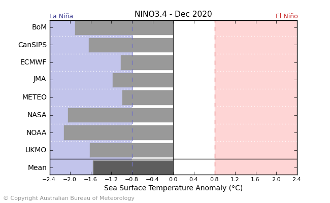
Latest Niño 3.4 multi-model ensemble from BOM is pretty locked into a moderate or even strong Niña peak in December.
Yeah I was looking at that yesterday it's definitely not out of the realm of possibility. Do you know what may be causing the NOAA/NASA/BoM models to go stronger? Wasn't sure if it was a model bias of some sort. One thought of mine is that those models in particular have a stronger area of suppression over the central Pacific resulting in stronger easterlies?
-
5 hours ago, Snowstorms said:
Forgive me if I am wrong as I'm still learning about the Hadley Cell Circulation and Global Angular Momentum on my own, but doesn't a typical La Nina induce the expansion of the Hadley Cell?
Yep, mainly in low-mid troposphere.
-
1
-
-
7 hours ago, andyhb said:Further intensification and westward progression of the Niña seems likely should this trade surge on the ECMWF come to fruition. Looks to me like we’re heading for a moderate event. Seems like MEI is paralleling 2007 as well to a decent degree.
I agree. CFS showing it to a lesser degree:
-
2 hours ago, FlashFreeze said:
The most exciting thing that’s happened all summer on Myrtle beach, happened about 40 minutes ago, would this be from Beta?
Yep. Crazy to think my wife and I almost had our wedding less than a mile from where it touched down lol. Soundings pegged it pretty well. Would've loved to see this in person. This probably doesn't belong in this thread, but FlashFreeze started it


-
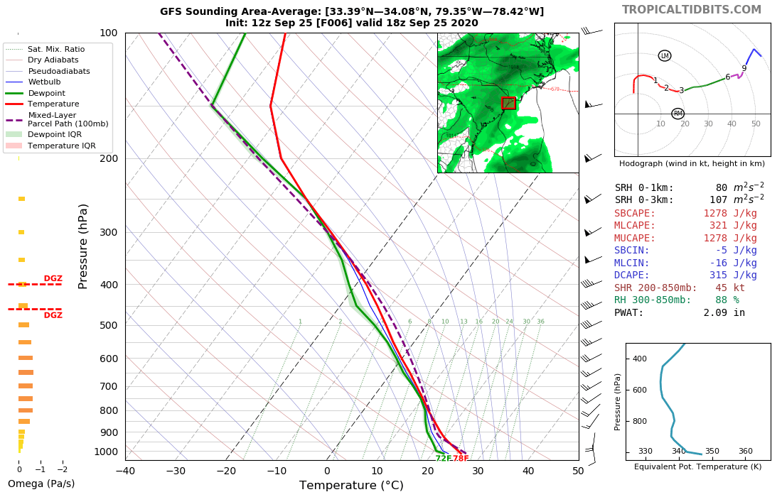
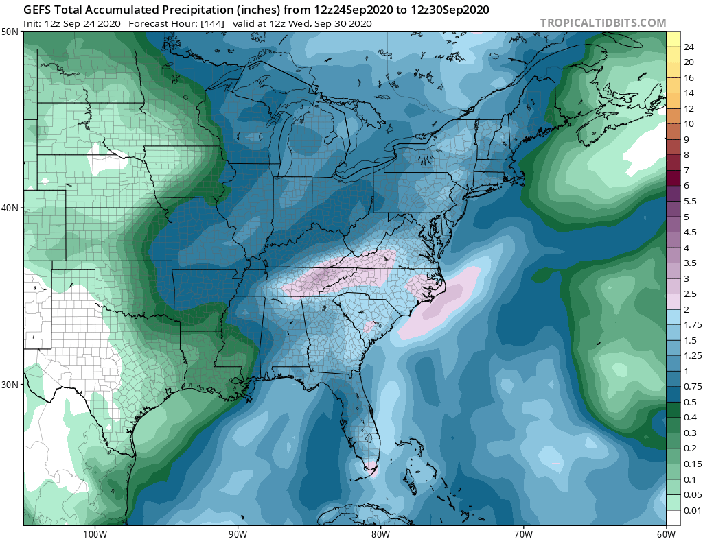
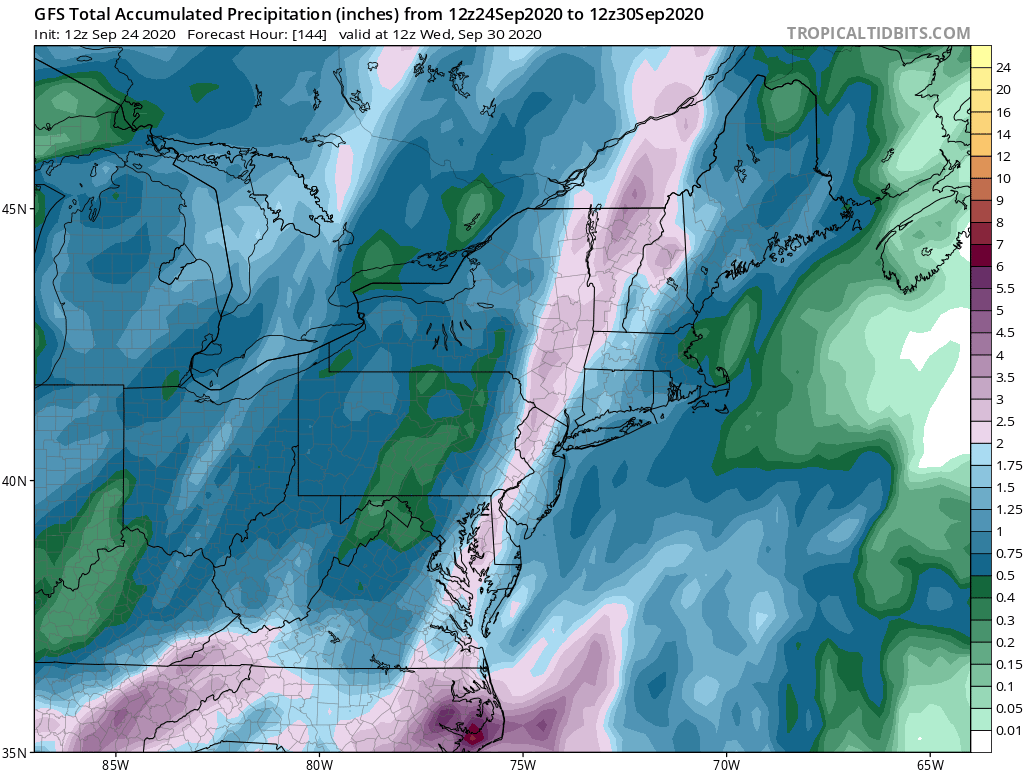
Appears most New England spots could see at least 0.5" which won't do much. What's interesting is 2"+ rains are not even hinted at on GEFS over Catskills/Adirondaks/northern interior New England.


-
Just now, CoastalWx said:
Someone in the northeast is gonna go from Stein to mudslides. That’s a great heavy rain setup. It will favor west initially, but between the front is a slow mover. Could have a low develop offshore too and bring rains to eastern spots towards day 8-10ish.
Yeah there is a great moisture fetch from the Gulf that should fuel this fropa.
-
5 hours ago, Baroclinic Zone said:
Interesting to read this as part of the Drought update. D4
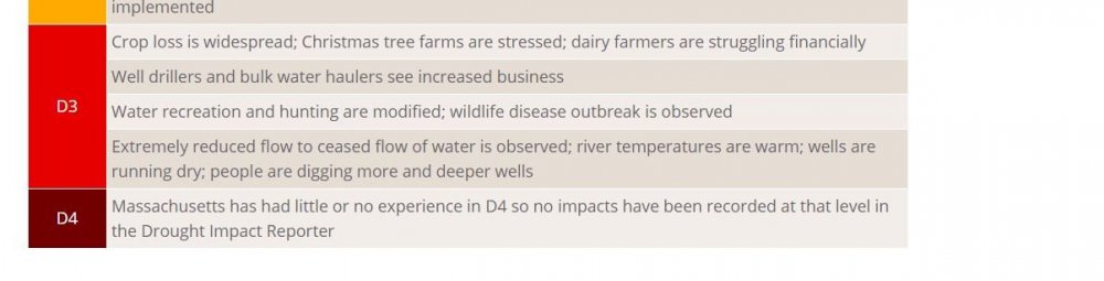 5 hours ago, TauntonBlizzard2013 said:
Damn we’re in D4?
I've been following the drought conditions up there and it's quite alarming in my opinion. I did some digging on climate statistics and this is what I came up with:
Boston is experiencing its 9th driest year on record thru 9/24 since when records began in 1936. It's also currently the 2nd driest Sept on record (0.35"), behind only 1957 (0.46"). Providence is experiencing its driest Sept since records began in 1932. It is also tied for the 5th driest year on record for Providence through September 24th (not including 1932 where records are missing).
Hopefully the expected rain on Monday helps alleviate some of that.
-
 1
1
-
-
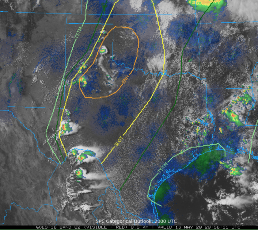
Cells starting to fire up...
-
I think July is optimistic (I was thinking as early as late August/early September) but if that EWB continues that robust end of July onset could be possible. Latter half of hurricane season should be interesting that’s for sure.

Wednesday, October 7, 2020 Convective Potential
in New England
Posted
So does this lose its chances of being tagged a derecho b/c it went OTS before it hit 240 miles?