

It's Always Sunny
-
Posts
1,946 -
Joined
-
Last visited
Content Type
Profiles
Blogs
Forums
American Weather
Media Demo
Store
Gallery
Posts posted by It's Always Sunny
-
-
Yeah looks like Euro has better phasing
-
Damaged goods. We cut and move on.
-
 1
1
-
-
7 minutes ago, WinterWolf said:
He likes are intellect here in New England....
5 minutes ago, MaineJayhawk said:
 4 minutes ago, WinterWolf said:
Spell check lol...should have reread it. Nice catch.
I thought you meant it like that lol.
-
1 minute ago, DTWXRISK said:
Ok I see it now. Thanks!
-
2 minutes ago, DTWXRISK said:
Atlantic teleconnections look great

What is the click path to get the model comparison chart on WxModels? I can't seem to find it.
-
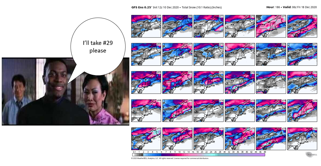
5 minutes ago, 40/70 Benchmark said:
I'd take #21.
#21 is a good solution for everyone to sip the Kool-Aid I agree. I like #29 mainly bc it crushes I-95 and east and tickles northern portions of 495 from what I can tell.
-
1
-
 2
2
-
-
-
Just got this at work...
-
 8
8
-
-
2 minutes ago, CoastalWx said:
I've had to weenie tag him already. Wanting severe and snow storms and getting mad when I temper his expectations.
Doesn't sound like he's on the road to trade school like you had hoped for a few years ago lol.
-
4 minutes ago, WxWatcher007 said:
You must be a proud papa. Gotta teach em young. Are you looking at the icon more than you’re letting on here though?
Lol. Scott had his son looking at weather models the day he came home from the hospital.
-
3
-
-
3 minutes ago, CoastalWx said:
Not sure what people are expecting, but it looks active with certainly some wintry chances in the northeast. It's called climo. Favored areas are N and W in December. However, it doesn't mean we all can't see something over the next couple of weeks. It looks better than it did a week ago IMO. Does it mean we score? No, it does not guarantee anything...but it's better than many December looks we've had previously.
For sure. I had a few days off but earlier this week it wasn't looking as good as it does now for second half of the month. Trending in the right direction.
-
ICON the dark horse

-
1
-
-
3 minutes ago, TauntonBlizzard2013 said:
Yeah.... I was going to say.... it’s a rainstorm. I’m not sure why people are holding out hope they’ll be glazed up... ain’t happening. Accept and move on.
Agree...it's not even what I consider a classic CAD setup. Maybe for NH & ME, sure but for MA not seeing it.
-
I thought this was the New England forum, not NY.
-
4
-
-
4 minutes ago, STILL N OF PIKE said:
If post 20z the winds at 850-925 veering to NNW..didn’t seem to effect the QPF could they have been responsible for a slight moderating of low level temps (via downsloping) when they turned this direction for Central mass over to S NH and why elevation maybe played a even bigger part than forecast for second half .
BC Nashua was like 32.5 mid day and then 33.5 34 late pm and evening .
Maybe so but that would probably happen more often during similar setups if that were the case. Others will likely add onto this but I think it goes back to the lack of lift in the DGZ.
-
 1
1
-
-
1 minute ago, WinterWolf said:
Good points. It goes both ways, sometimes we poo poo something and it still works out well because something offset the potential issue.
And sometimes we see the issues and feel this or that should overcome the issue, and it doesn’t. It’s not an exact science yet....humbling to say the least. Looking forward to the next threat.
Yeah exactly to your point. Like you said events that don't look so hot then do great, we pick out what went well, what overproduced, etc and we do the opposite for when we have high expectations and it doesn't materialize.
-
I know I'm speaking for others but events like these always leave a dent in forecasting confidence because there have been many times where the best lift wasn't quite in the DGZ but still yielded great amounts and then you have yesterday's storm that pretty much puts us back in check. I remember earlier this year (I forget the date Will probably knows lol) but mid level dry air was a potential issue which made many of us poo-poo it but most of SNE ended up doing really well. If I can find the date I'll update this post but point being that was a storm that left a dent as well.
EDIT: December 11, 2019 event with the mid-level dry pocket.
-
1
-
-
1 minute ago, ORH_wxman said:
And the best zone that had decent lift in the DGZ was further west over ORH county into adjacent S NH...so they had the double advantage of better DGZ lift plus some elevation. It’s probably why you saw like 9-12 inches of snow there while Ray in Methuen was struggling to get 2”. You hardly ever see that type of gradient unless he was mostly raining which wasn’t the case.
Yeah looking at METARs this morning I was seeing several hours of snow reports for lots of places along the coast but then only saw like 1-2" total. Unique event for sure and most places changed over sooner than modeled (even though we knew that would probably happen).
-
2 minutes ago, CoastalWx said:
I think spatial area coverage too. Big hooked dendies will be efficient in cooling.
Goes back to what you said originally though Scott how most places didn't see flakes flourish in the DGZ. I remember looking at soundings and x-sections yesterday and saw the same thing. Best lift was either above or below it (at least the stations I was looking at).
-
1 minute ago, CoastalWx said:
Come back to New England.
Haha not likely but you never know. My wife and I both moved to TX separately never thinking we'd be here this long lol.
-
I think it really depends on a few things: how that Rex Block breaks down, how soon after the low over the west coast lifts out once blocking departs and how that s/w interacts w/ what comes out of Pac NW. If I had to place a bet I'd still say it cuts but those are three things that I think could cause models to tick east. Yesterday's storm was originally a cutter around December 1st and it became a coastal so I think there's at least some room for optimism.
-
1
-
-
There's still a chance for that Dec 13-14th event to amount to something for New England. Models have a Rex Block set up over western US which then eventually breaks down and that ridging pattern traverses the rest of the country with our next storm system trailing it. Unfortunately that could very well lead to it cutting it just depends on how much that ridging breaks down out ahead of it. Chances don't look great though but maybe get some back end snow out of it.
-
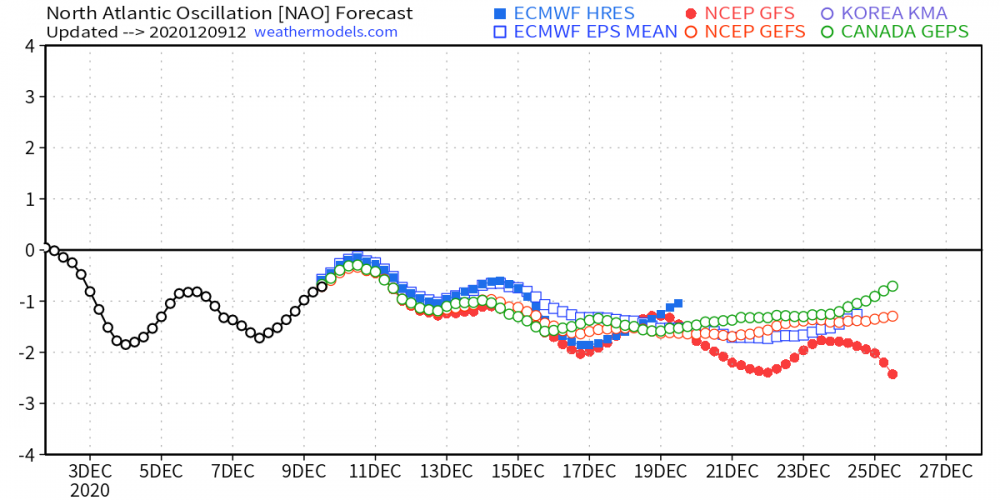
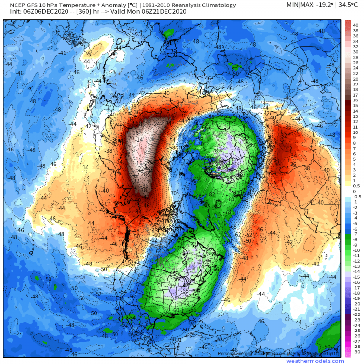
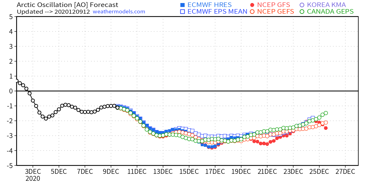
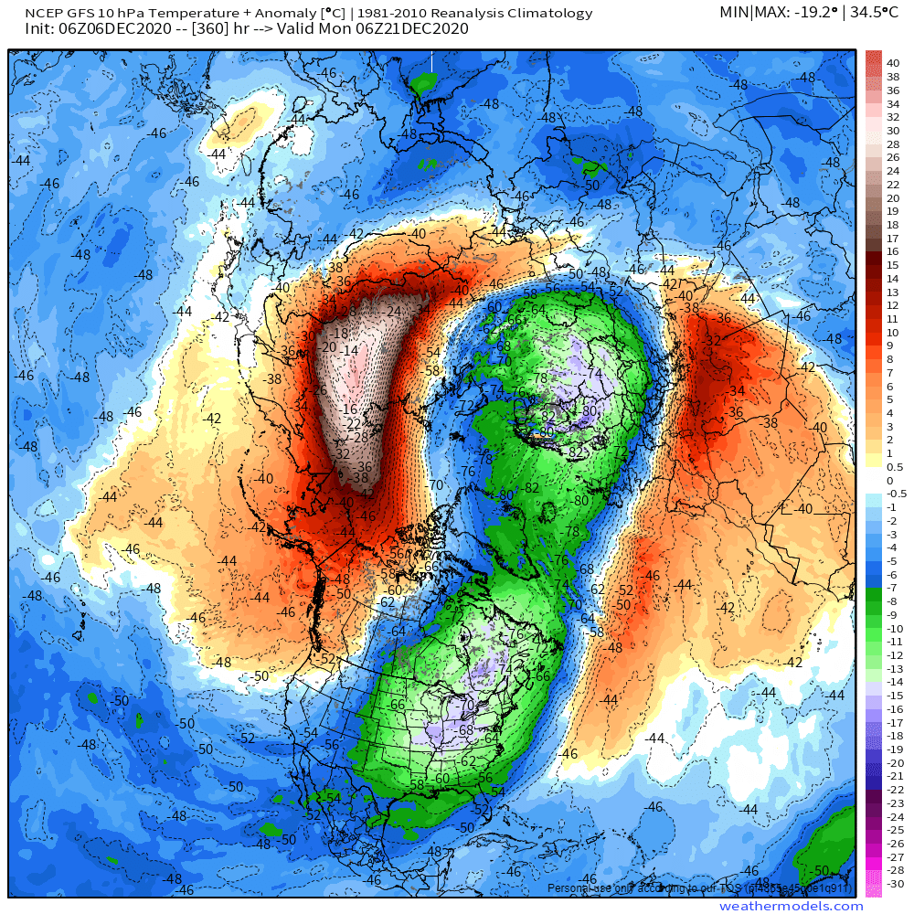
I see some warming over Siberia...could have some implications for end of this month or early next year.
-
1
-
-
Waking up to snow totals this morning
 . Hoping NWS updates these and we see some increased totals.

Active mid December with multiple event potential
in New England
Posted
Is it just me or is the Dec 16/17 storm beginning to look more Miller A-esque? Almost a Miller A/B hybrid kind of.