

It's Always Sunny
-
Posts
1,946 -
Joined
-
Last visited
Content Type
Profiles
Blogs
Forums
American Weather
Media Demo
Store
Gallery
Posts posted by It's Always Sunny
-
-
Appears it will cover the same area as yesterday. Cross-over winds aren't eye-popping but still enough to generate some tors.
-
-
13 minutes ago, wx2fish said:
Congrats in DFW?

Haha I wish! Next couple weeks may be relatively quiet here but climo can do amazing things sometimes.

-
Good thing Sox aren't playing they'd be making snow angels on the field.
-
-
Hey on the bright side of things this could lead to a couple marginal to slight risk days for some
 . I know Wiz will adhere to that haha.
-
56 minutes ago, Ginx snewx said:
Pattern is late to the party you guys could've used that this winter. This is just a sputtering end to a dreadful winter for most.
-
 1
1
-
-
6 hours ago, WhiteoutWX said:
Put this in the wrong thread earlier:
Deterministic and ensemble guidance are all in relative agreement in this pattern persisting in the mid to extended range, with a trough over the east and ridge over the west. Even occasional hints of transient high-latitude ridging over the NAO domain which suggests this pattern may be slow to budge. I think it's pretty safe to say April is probably toast at this point for anyone outside the Gulf Coast states as far as tornadoes are concerned. May is still 10+ days away so we'll see how things evolve, but no real sign of a change to a more favorable plains tornado pattern for the foreseeable future.
That being said... looking in closer range. Tomorrow evening offers some localized tornado risk for portions of the TX Panhandle into western and southern Oklahoma as the warm front lifts northward. If sufficient moisture can return for surface based convection, deep and low level shear is favorable along this corridor for at least a tornado or two.
Yeah I started noticing that possibly happening last week and today I was looking at the subtropical jet and it loses it's steam next week which further dampens any severe risk, at least here in the Plains however with some troughing remaining over the Southeast there still remains a possibility they get a day or two of severe potential, even with a "weakened" subtropical jet. This "lull" has the potential to spill into the first week of May based on what I was looking at but too far out for me to put much stock in it at this time.
-
3 hours ago, weatherwiz said:
I was actually a bit surprised to see the upgrade to slight. I think we'll see some pretty strong wind gusts but not so sure we see defined severe winds...but then again our trees fall at 40 mph winds so. I also think there could be showers ahead of the main action which could hamper the severe threat
I was surprised myself. HRRR is showing the strongest gust potential with a LLJ around 50kts that would presumably mix down to meet severe criteria, but yet it also has the steepest low level lapse rates which the other models aren't as steep. You can make a case for it. Although the other models aren't showing as strong of a gust potential, if they get some good low level WAA that could steepen lapse rates enough to mix down some of those stronger winds. We'll see, but not overly optimistic.
-
1
-
-
Upgraded to slight risk Wiz
-
1 hour ago, CoastalWx said:
May be a few flakes to end.
That's what you call a happy ending
-
1
-
 1
1
-
-
1 hour ago, weatherwiz said:
Looks like the main mode is linear which may scale back hail potential but I’m wondering if we could actually see some large hail?
I think small hail is in the cards like you said above because nearly every ingredient for hailstone development is there except good CAPE. I don't see any chance of large hail although nothing wrong with wishful thinking I've been there before lol.
-
 1
1
-
-
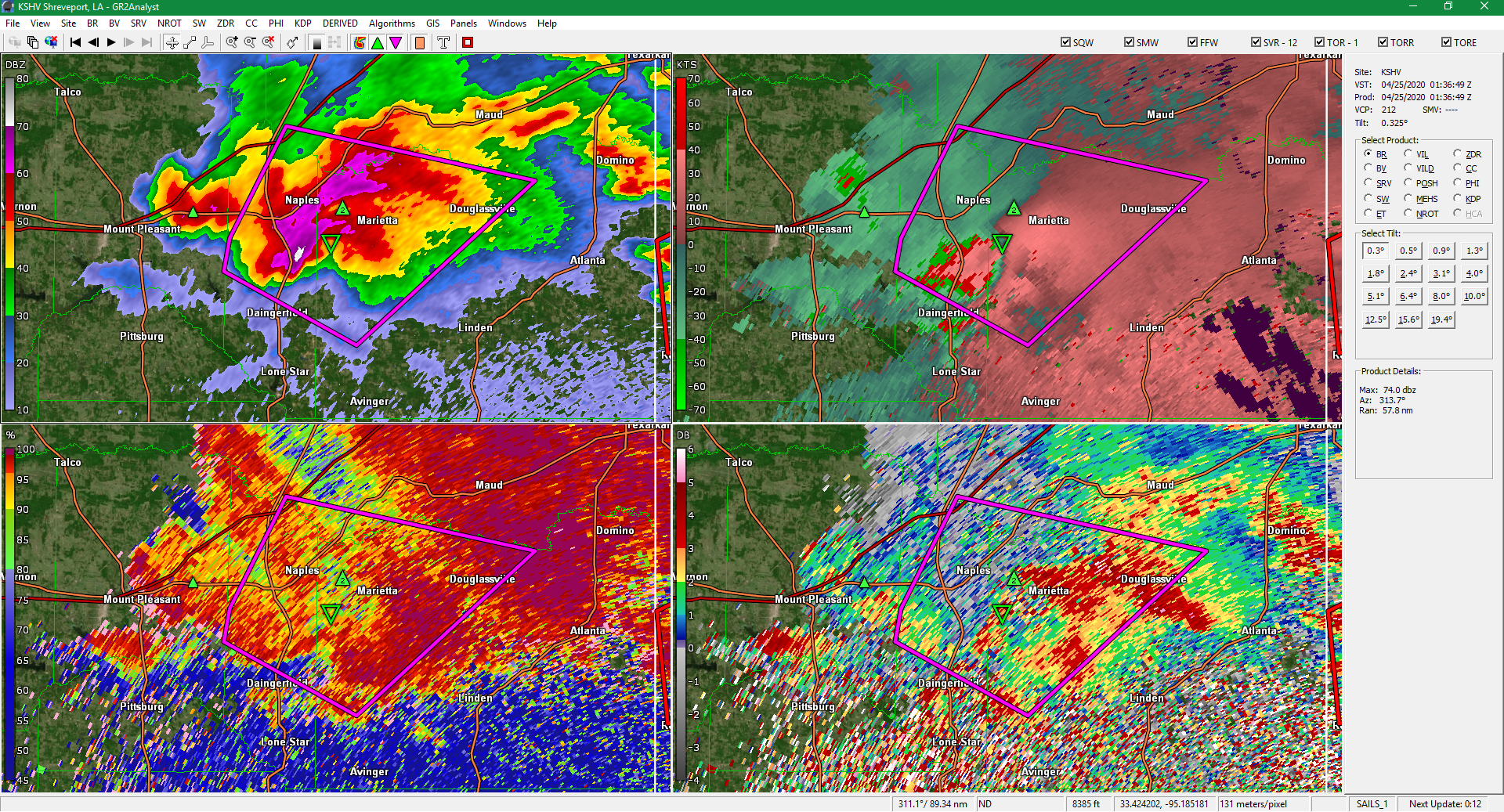
Looks like we have initial rotation over TX/LA border...
-
8 minutes ago, jojo762 said:
Looks like some clearing is trying to happen north of the outflow boundary across southern Alabama & Mississippi; this might be enough to force the effective warm front further north. As referenced in the BMX tweet though, its not going to be easy with that high pressure in Georgia, in addition to the sharp nature of the front with only upper 50s temperatures on the cool side of the boundary.
I also think those morning storms north of the front provided a decent amount of evaporational cooling reinforcing it. Kind of similar to what happened in northern IL last month with the severe weather bust.
-
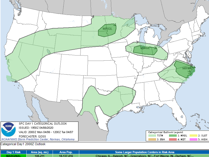
9 hours ago, BrandonC_TX said:
Interesting enough SPC includes a significant hail risk today (4/19) for half of the DFW Metroplex, primarily Dallas and Collin counties eastwards.
Got 1/2" here. Wasn't looking like much at all this morning had some isolated showers and storms that ended up weakening then around 10am storms redeveloped quickly along western fringe of metroplex. Looks like it was subtle convergence boundary aloft tapping into a very unstable airmass with those steep lapse rates.
-
29 minutes ago, cheese007 said:
Might see some half dollar hail in Dallas, TX in a bit
Reported 1/2" here at Love Field. Larger hail reported areas west to as large as half dollar.
-
1
-
-
1 minute ago, TampaTwo said:
This is my early call on where SPC may set a PDS watch box for later this afternoon/tonight....and the purple inset is my guess as to the highest threat zone.
Yeah I was thinking the same thing this morning seeing where that MCS passed to the north, leaving this whole area untouched. Also surface temps to the north not that great, south much better.
-
I like what the SPC has out but definitely going to monitor srn MS/srn AL with that MCS pretty much missing them this morning they are primed and ready to go this afternoon and tonight.
-
Op GFS remains active for remainder of the month so remains to be seen if it changes course.
-
Next week or so looks favorable for severe but end of the month/early May in question with EPO trending positive per GEFS. EPS following similar suit.
-
26 minutes ago, BrandonC_TX said:
Another point of note: observations of dew points in most of northern Ohio are in the mid-to-upper 20s right now (although dewpoints are about 50 down by Cincinnati). Today's 12z and 18z HRRR runs show northern Ohio to be a possible area for (potential?) surface-based convection tomorrow afternoon, and I am having trouble believing this scenario given how dry the surface airmass currently is. That said, SPC has said this would be an area of subsidence following the morning convection.
18z NAM3K puts 60s dewpoints in place across all of Illinois, Indiana, and most of Ohio (except the NE corner). Both 18z NAM3K and NAM runs would be more favorable for isolated tornadoes given lesser T/Td spreads relative to HRRR runs (although HRRR does show more convective activity, it also shows more mixing and thus larger T/Td spreads).Yeah I'm with you have a hard time seeing any sort of convection in northern OH tomorrow afternoon (despite HRRR showing development of a little convection there). I just don't see the atmosphere destabilizing quickly enough to generate anything surface based at least until tomorrow evening. It really depends on how the convection fares this evening and into tomorrow morning but an area of subsidence following the morning convection makes sense.
-
1
-
-
Once that ULL passes through in about 4 days or so the ensembles remain mostly favorable through the end of the month for unsettled weather here, including severe potential. May not be in your backyard stuff but even on the 12th that area just east of the panhandle and over SW OK could be in a marginal or slight risk potentially and of course that can all shift so not a high confidence forecast by any means but there is certainly potential imo. Then from there on out we still got ridging over the west and troughing over central part of CONUS. That along with climo (it still being early in the month) I remain optimistic which I feel like is the general consensus here beyond day 10.
-
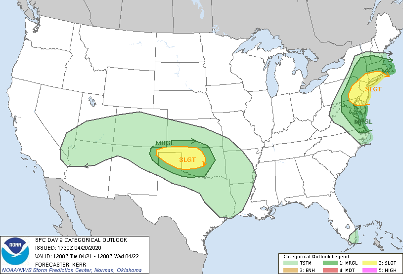
9 minutes ago, Chicago Storm said:
Can’t figure out at all what the SPC is doing.
Not only the very questionable SWODY2, but not the new SWODY1 completely removes marginal for anywhere...when it’s pretty clear there will be a hail risk that warrants a marginal corridor.
.I see MRGL still included in 20Z update. Day 2 is interesting lots of things at play. Morning convection will have a big influence on what gets going over the OH Valley in the evening. Also models are in disagreement on placement of that LP which moves over MI tomorrow night. HRRR & ECMWF bring it through about 3-6 hours before the NAM & GFS do which can result in two completely different outcomes mainly concerning how fast OH/PA can destabilize again tomorrow afternoon.
-

Monday, May 11, 2020 Gusty t’storms
in New England
Posted
I think seeing mid-level lapse rates pushing 8.0C/km is more fascinating than the t-storms you'll be getting tomorrow as exciting as that is too.