

It's Always Sunny
-
Posts
1,943 -
Joined
-
Last visited
Content Type
Profiles
Blogs
Forums
American Weather
Media Demo
Store
Gallery
Posts posted by It's Always Sunny
-
-
18 minutes ago, BrandonC_TX said:
Might want to watch that area along the I-35E corridor between Italy and Waxahachie for the development of a potential hook. Conditions are not particularly favorable for strong rotation (EHI values, both 0-1km and 0-3km, are between 1 and 2), but the storm may be taking on supercellular characteristics based on the radar signature. This storm is also moving straight towards Dallas as well, and if it strengthens it could pose a severe thunderstorm threat.
Fortunately there is no velocity couplet, and the storm is sub-severe, but I will be watching the I-35E corridor.
Yeah I'm tracking that storm right now on GR2. Had to go out and move my car in the garage I don't trust that thing lol. Certainly has some hail in it but rotation isn't evident at this time however now is the time that wind shear is over us.
-
Storms already firing up south of Waco
-
4 hours ago, BrandonC_TX said:
There is a cluster of warned severe thunderstorms out in far western Texas right now. Some of the NAM, RAP, and HRRR runs have me a little bit concerned about the possibility of a "sleeper" severe thunderstorm and/or tornado threat in north-central Texas this evening into the overnight, as a boundary appears to stall over the DFW area with strongly backed surface winds along the boundary. If this scenario verifies and a storm can latch on to that boundary, it might become a bit troublesome.
Interestingly enough, there is also a severe thunderstorm watch up for the island of Kauai in Hawaii. (This isn't displayed on SPC's page as a watch since we are talking OCONUS here)
EDIT: a severe thunderstorm watch is now out for the areas around Lubbock. Severe-warned storm west of Lubbock is taking on supercellular characteristics based on radar.Totally agree. Not sure if you read NWS discussion but it mentions low level vorticity along the frontal boundary, which one normally wouldn't think to look at (usually 500mb is observed more frequently). Anyways it appears between 21-03Z that front lifts north, not only providing necessary lift, but also good WAA/Theta E advection and then throw in the increased shear in that timeframe could be an eventful evening. Expecting storms to fire up south of I-20 after about 3-4pm. Could see some become severe warned shortly thereafter as the environment they will be moving into becomes more favorable. Looks like the front is currently just south of Corsicana which is also evident on radar too.
-
Absolute torch today. Wx station at home is reading 90F with other wx stations around reading between 88-90F so it's legit! Should set the stage for some good thunderstorms tomorrow night.
-
Some severe potential coming together for DFW early evening tomorrow along nice surface convergence boundary. Cap appears to be in place but around 21Z models erode it. Hodos have a weak and subtle curve but may generate a couple isolated supercells. SPC has marginal out so it definitely bears some watching. Risk overall is low but certainly bears watching.
-
1 hour ago, Chinook said:
It looks like a 500mb low will be in Arizona and New Mexico, on Friday morning, possibly tracking toward SE Colorado and SW Kansas. We will have to see how the models handle the synoptic details in the next few days.
GEFS & EPS look favorable for potential severe across TX and parts of srn/cntrl Plains.
-
1 minute ago, weatherwiz said:
What I find half amusing is the general public will complain about hyped weather forecasts yet they keep reverting back to the SAME sources which hype weather...it's like they're drawn in and can't escape. This is why there is truth to what Kevin says...hype sells. Hype does sell and it's an unfortunate shame.
I've had to do that too with TWC haha...last winter someone at work sent me this article about that was written about the Polar Vortex...I had to explain what it was and what it really meant in terms of weather.
Lol I know myself and I'm sure other mets on here have had to deal with that too. That and bombogenesis.
-
 1
1
-
-
6 minutes ago, OSUmetstud said:
I'm pretty sure models handle fast flow regimes considerably worse than slower, blocking regimes. The 2009-2010 winter was a benchmark for great medium range modeling. When everything is low amplitude and super fast, things can either appear or disappear pretty quickly.
4 minutes ago, weatherwiz said:Agreed...I think I mentioned that a few times as one of the main reasons why models have struggled. When flow is fast there are usually so many moving pieces and any one of those can be the main player.
I agree with that as well. One setup I think that can be excluded from this assumption are Clipper systems; those are easy to track despite them being quick hitters.
-
1
-
-
9 minutes ago, weatherwiz said:
This is actually something I think about alot. Was it the case of the models being bad or is it how information is being portrayed/relayed? I know I've said this a million times but I think it's important enough to do so. This is something you see all over social media and I saw it at school but too many folks just run to model snowfall maps, SLP maps, QPF maps and use those as a basis for a forecast or as a means to communicate weather instead of analyzing the bigger picture. (This isn't pertaining to anyone here on the board...this is geared to social media/what I've seen from those around me). But what happens is these situations don't pan out and the models get the blame and nobody wants to take responsibility for their wrong doing.
I know you're part of many groups on facebook and active on twitter so you'll know what I'm talking about but so many people try to use a model snowfall map for however many days down the road as a basis to indicate there is potential for a storm or a big storm...now I guess in a way you can do that as it means the model is "showing a storm". But just b/c a model shows a storm doesn't automatically mean there is potential. The bigger picture needs to be analyzed. If the model is showing a storm but the pattern doesn't seem to support it or it doesn't make sense...chances are it's not going to happen. You can't assess this just by looking at a QPF map or snowfall output map.
Before these model snow maps became a thing actual forecasting and diagnostics had to be a thing. How many of these D7-10 day storms would get the attention they did without them? Probably very few of them. I get it's fun within the weather community and it's all good fun to post them here (b/c everyone knows how to handle them) but when they get tossed around social media it becomes a big problem and it generates hype. This is leading to the public to lose confidence in meteorologists...I hear this stuff all the time from people.
IMO though winter weather forecasting has become terrible and the biggest shame is the ones out there who do a phenomenal job with it (forecasting, communicating, etc) are being overshadowed. People look at snow maps and it's off to the races. GFS snow map shows 15-25'' over a large area (even though when looking at the setup it's extremely unlikely) and it's "sound the alarms...historic storm coming". Storm happens...drops 8-12'' (still significant) and it gets labeled bust b/c a freaking map output showed 2-3x that.
I don't understand the love for the model snow maps...whether it's just pure laziness, the fact they can show a ton of snow which people love...idk. It's not like they even incorporate the most important ingredients to determining snowfall. Oh yeah let's take model QPF (which models suck at to begin with) and multiply that by a fixed constant ratio (which ratios throughout the storm are not fixed or constant) and viola that's how much snow is going to happen...and then...and then you have the maps WHICH INCORPORATE SLEET....WHO THE HELL CAME UP WITH THAT IDEA???? Take that code and slap it right across the face of the individual who did that.
Obviously models aren't perfect and they are subject to wavering (even inside a certain amount of time) but if there was more focus in analyzing the synoptics and features aloft with enough skill and knowledge very solid forecasts can be made...this is how humans beat computers in terms of forecasting and why computers will never take over. Forecasting is much more than just rip and reading model output and making a forecast.
Unfortunately we live in a society where television viewers and Facebook/Twitter dominate. Those with weather knowledge know better than to buy into the stuff we see plastered all over the internet and tv but the general public latches onto that type of stuff. Those with knowledge should also know better to look at things synoptically or taking a look at the ensembles to see if the operations solution even makes sense and is feasible.
I work in an environment where they play the Weather Channel on tv and I swear half my job is to calm everyone down based off what they see.
-
1
-
-
Off topic of this exhilarating discussion about road treatment options, check out these Mount Washington obs from today so far. They obviously have a great reputation for strong winds but don't recall seeing winds of this magnitude for a bit. Blue Hill reporting gusts near 50kts.
KMWN 041947Z 28087G96KT 0000 -SHSN FZFG BLSN VV000 M11/M11 RMK PK WND 280105/26 VRY LGT ICG
KMWN 041851Z 28084G92KT 0000 -SHSN FZFG BLSN VV000 M11/M11 RMK PK WND 280105/00 VRY LGT ICG
KMWN 041747Z 28081G92KT 0000 -SHSN FZFG BLSN VV000 M11/M11 RMK PK WND 280106/08 LGT ICG 60017 4/020 931008 11084 21112
KMWN 041554Z 28088G101KT 0000 -SHSN FZFG BLSN VV000 M10/M10 RMK PK WND 280113/15 LGT ICG
KMWN 041452Z 27088G102KT 0SM -SHSN FZFG BLSN VV000 M09/M09 RMK PK WND 270116/09 LGT ICG
KMWN 041347Z 27085G102KT 0000 -SHSN FZFG BLSN VV000 M09/M09 RMK PK WND 280112/1256 LGT ICG
KMWN 041247Z 28089G100KT 0SM -SHSN FZFG BLSN VV000 M09/M09 RMK PK WND 270106/45 SNE20SHSNB20 LGT ICG
KMWN 041154Z 28084G100KT 0000 -SN FZFG BLSN VV000 M09/M09 RMK PK WND 260108/43 LGT ICG 60030 70047 4/020 931015 11015 21087-
1
-
-
15 hours ago, BrandonC_TX said:
If we are going to see above-normal temperatures and precipitation at the beginning of March, perhaps the severe storm season could start to ramp up. GFS and Euro are both depicting a storm system for the Southern Plains for early next week (around March 2nd), with what seems to be sufficient moisture return across Texas into southern Oklahoma. We are still a ways out, so any model data should be taken with a grain of salt, but the modeled pattern caught my eye (with multiple low-pressure systems moving out of the Rockies on the GFS, and a big storm on the Euro). I'm a little concerned about the late-week storm (that should impact the Great Lakes with snow) scouring the Gulf of Mexico of moisture, though water temperatures are above average across much of the GoM.
Yeah I agree to not put too much stock into ops models this far out but ensembles do favor unsettled weather around here first week of March so we'll see how it verifies. Ensembles mid to late March don't look quite as favorable (at least for now).
-
5 minutes ago, eyewall said:
There have been a few sleet reports north of Raleigh already today as an FYI.
Have you seen actual pellets there? Surface temperatures are in the upper 40's wasn't sure if their ASOS was reporting accurate info.
On a separate note 12Z Euro in good agreement for RDU with 1-3" possible.
-
2 minutes ago, SnowNiner said:
Thanks, yeah that's been exactly my fear all along. GFS was in and out of there quick too. It's NAM or nothing at this point for mby.
Yeah unfortunately NAM is the outlier but on the bright side of things the fronto band remains aligned in the same location for the most part, just a little less robust on 12Z GFS but nothing I'm too concerned about regarding accumulating snow.
-
 1
1
-
-
3 minutes ago, Wow said:
QPF slightly less but it's the sfc temps killing the snowfall amts
Yeah it's definitely concerning. It's a storm where dynamics will have the final say. If it snows hard enough low level temps can easily wet bulb to allow accumulations. Could be a situation where the roadways are fine but grassy surfaces get a couple inches depending on where you are.
-
 3
3
-
 1
1
-
-
Looks like LP shifted a hair ESE which is dragging the QPF with it. Haven't analyzed temperature profiles yet to see if anything has changed with that.
-
1
-
-
GFS has backed off a bit on totals.
-
1
-
-
19 hours ago, BrandonC_TX said:
Had a dusting of snow up near Texas Motor Speedway earlier today.
Had nothing significant here near DFW airport other than some wintry mix that ended up melting once it hit the surface but I think models did a fairly good job depicting the northwest to southeast temperature gradient.
-
1
-
-
19 minutes ago, OceanStWx said:
Well the ASOS measurements are relatively new, so we're kind of standardizing them now. We have typically forecast radial and measured that way in New England. I think part of spotter training going forward needs to focus on stating your measurement method and the NWS will have to decide how to report it on an LSR (e.g. reporting flat but remarking that it was taken radial).
NWS is supposed to forecast flat ice now. This was never how it was done regionally. So ice storm criteria of 0.5" is more akin to damage expected from radial accretion. If we issued ice storm warnings for flat ice that's like 0.2" radial. That's not going to be much damage.
What is your runoff correction? That's a common topic of debate when forecasting ice at least during my time in the field.
-
3 minutes ago, cheese007 said:
Oh warm air aloft is part of what I was referencing. Have had so, so many setups get killed by it these past few years
I agree. These fronts are always so shallow which keeps me leery of the entire column cooling enough to produce wintry precip.
-
The cold air will obviously be there at the surface but I'm more focused on the temperatures aloft which will be the determining factor. GFS nukes lower levels (resulting in cold rain/freezing rain) while NAM and Euro run colder (likely sleet/snow/patchy freezing rain).
-
Lots of varying solutions with NAM being the coldest thus far. It's still too early to tell if Dallas will be a wintry mix or cold rain.
-
Precip amounts are meager as well for coastal SNE

-
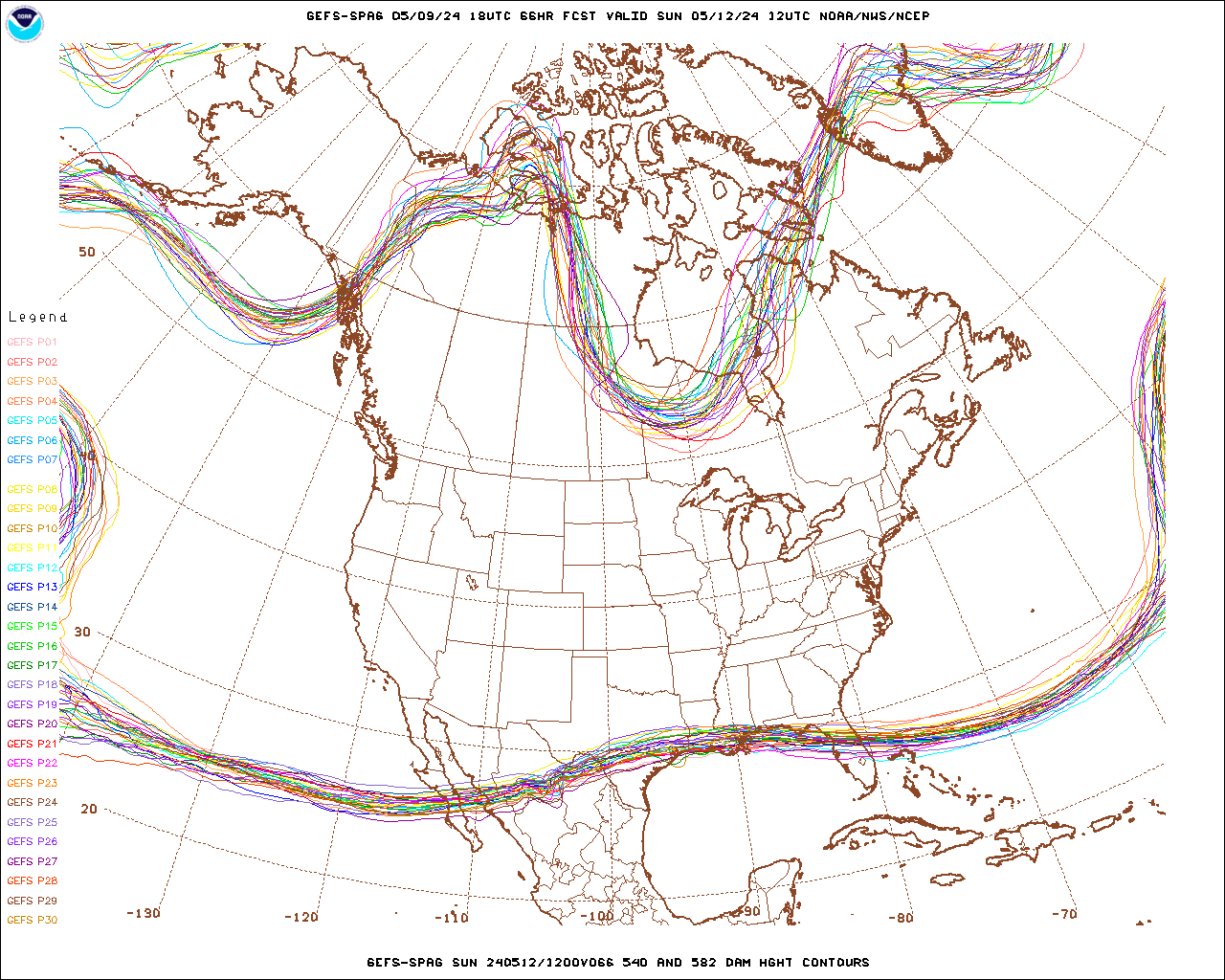
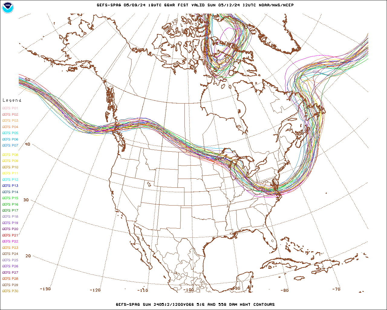
Crazy spread with that 558 DAM trough.
-
3 minutes ago, DotRat_Wx said:
For the 3rd time.... This trof is full of sh*t it ain't Happening. Don't see how it's possible. It's like a 1 in 50 chance for a moderate snow storm. Too progressive. Too much mixed up in the flow
To your point that screaming jet streak across the southeast doesn't help anyone but even if that jet streak weakens it's still very progressive flow which sucks. Banking on those two troughs to work themselves out.
-
1
-
Severe Weather March 15-19
in Central/Western States
Posted
Yeah I was literally just looking at that. My biggest concern will be timing to destabilize after today's weather and then any cloud cover overnight and tomorrow morning. All the other ingredients are there though although I feel that mid-level lapse rates could be better but when you have that type of shear, low level moisture and CAPE exceeding 1000 J/kg lapse rates don't need to be as steep.