

It's Always Sunny
-
Posts
1,943 -
Joined
-
Last visited
Content Type
Profiles
Blogs
Forums
American Weather
Media Demo
Store
Gallery
Posts posted by It's Always Sunny
-
-
On 12/11/2019 at 10:27 AM, dendrite said:
I think the GFS was just overzealous with the dry air. The precip was heavy enough too to keep any slightly drying layer saturated with sublimational wetbulbing. That 3km NAM I just posted was a lot more moist at H8 over C CT than the GFS was.
I think everyone's breakdown of this storm was great (what happened, why it happened, what could've been different if xyz happened, etc.). One thing I want to add is I think there was some true seeder-feeder action as well where the upper level clouds (where the impressive SG was) fed the lower level clouds despite that dry air in place. I really think it expedited the saturation (wet-bulbing) of that dry pocket. If SG wasn't as great, this may have taken longer to achieve obviously resulting in lower snow totals. Either way, it proved to be a challenging forecast when analyzing the impact this dry pocket of air would have. I think this storm had incredible dynamics where many were able to apply true meteorology reasoning to it whether your forecast verified or not. Great job, everyone, except the Yankees

-
5 minutes ago, The 4 Seasons said:
Is there a way to find out what the climo sites have so far?
This is what I use assuming you know what the climo sites are: https://www.weather.gov/source/crh/snowmap.html
-
Just now, CoastalWx said:
Ha thanks bud. Seems like it’s happening. Light snow now and 33 here.
Hey! Since you're here now see my inquiry above lol.
-
Just now, weatherwiz said:
Man that couldn’t have been more spot on.
Do you know what's the "second wave" he is referring to? There is a s/w that drops in from the north but not sure if that is it.
-
2 minutes ago, weatherwiz said:
The NW part of the state has the be getting drilled. Wouldn’t be surprised if some towns there have like 3-4” already...maybe close to 5
That along with their higher elevation I wouldn't be surprised either. Here is what Scott said earlier so far I think it's right on lol.
"One other thing possible, we may have two “max” zones. One maybe near central MA into adjacent or NW CT? This due to initial dynamics residing as it changes to snow before drying out. Then, another area in RI and SE MA. This from the second wave mixing in near 12z. Could be an area that gets less than 1-2” in between. "
-
1 minute ago, weatherwiz said:
Might Be starting to see influences now. Noticed radar lightening up a bit in CT outside of the heavy band near the NY/CT border.
I think Scott mentioned two maxes...one near W CT and another NE CT into MA...might work out very well
Actually looking at GR2 if you toggle different radar tilts you can see some of the dry air pockets so it's definitely there, just waiting for it to start eroding some of that precip which with those moderate bands may be hard to do in the near term.
I remember Scott mentioning that I'll have to look back and see what he was looking at.
-
5 minutes ago, weatherwiz said:
Even now looking at radar. Been watching the western edge for signs of dry air. When it seems like it starts to get eaten away it quickly fills back in.
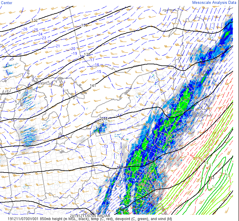
Low level water vapor loop has all the dry air off to the south over central NJ moving NE. GFS soundings do show that dry air making its way in within the next couple hours but NAM has a different idea keeping column fully saturated until just about daybreak.
-
2 minutes ago, weatherwiz said:
Yeah it’s all good. Can’t get upset. In these situations where there are mixed signals you pick a stance and go with it. In this instance I opted to go for dry air winning out. It’s all good
Yeah that's what I was leery of. That pocket of 850mb dry air was peppered all along the front from New England to Texas so it was tough to commit to who would get screwed and who wouldn't.
-
1 minute ago, weatherwiz said:
Up to a coating lol
Eh it happens to everyone I wouldn't sweat it.
1 minute ago, The 4 Seasons said:Did you make a call?
No not officially but I was thinking generally 1-3" for most, maybe a couple isolated 4" amounts.
-
2 minutes ago, weatherwiz said:
Not a whole lot of W to E motion on the radar it appears.
Yeah steering flow looks like it is straight out of the SW. How much did you call for in CT I must've missed that post.
-
10 minutes ago, weatherwiz said:
Woah...this is crazy. The HRRR like stalls a band of heavy snow over CT for like 3-4 hours.
Cashing in on that frontoband and looks like a nice s/w at 850mb...
-
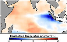
3 hours ago, raindancewx said:
Euro trended warmer, finally, for Nino 3.4 in the December update. No members below -0.5C through July now. I like the high end of the plume through February, then transitioning toward the low end in Spring but we'll see.

It did well last December -

I like what it is doing as well and agree with it to some degree, considering the continuous push of warm water east however is this model taking into assumption more warm water pushing east from Maritimes in conjunction with a modeled weakening of trade winds?
-
13 hours ago, cheese007 said:
Don't even have any precip here and I'm supposedly right under a snow band
There was some considerable low level dry air associated with this anafront which gobbled up a lot of what little QPF there was to begin with. That, along with a more pronounced warm nose than modeled was the nail in the coffin for any wishful snow chances here.
-
 1
1
-
 1
1
-
-
Just now, The 4 Seasons said:
It's frustrating to take a deep dive at forecasting because BUFKIT and many sites with soundings only provide them for the GFS/NAM. Both of these models, imo, are inferior to the ECMWF. But the ECMWF i cant see soundings or use points on BUFKIT or even have an EC-MOS type data that i can get with the american models.
I still have yet to find a website (including paid) that provides ECMWF soundings. If anyone knows of them please let me know. In the meantime I usually have to have 6 windows open with different variables displayed to paint a picture so to speak.
-
8 minutes ago, 40/70 Benchmark said:
Been 1-3" with spot 4" since the get-go...no change. Fraud refers to the tendency to underperform expectations....doesn't mean P sunny skies. Pretty simple.
I agree with the 1-3". I remain overly concerned that 850mb dry air pocket is going to eat up some of that QPF. If that solution verifies, great, people get 1". If it saturates more than modeled then people end up with 3". It's a win-win lol.
-
On 12/8/2019 at 11:56 AM, raindancewx said:
Nino 4 (160E-150W) has really warmed up again back down to 200m over the last month. Nino 3.4 should re-warm too. It looks like the cold and warm water are both pushing East, so the Modoki look from Fall should come back. After that, probably a rapid collapse toward a La Nina sometime in Spring? Models have been showing that lately. It looks like the Indian Ocean Dipole look is collapsing or at least reversing too - rapid cooling of the waters by East Africa / Madagascar and rapid warming of the waters by Indonesia.
Ideal +IOD

You
You think that developing EWB over Nino 4 will put a bit of a damper on the anomalous warm water pushing east? I still think it'll be enough to warm Nino 3.4 but maybe not quite as much as we think? I still think CFS forecast may be underdoing it a bit but that's just my opinion.
-
4 hours ago, cheese007 said:
Hmmmmmmmmmmm
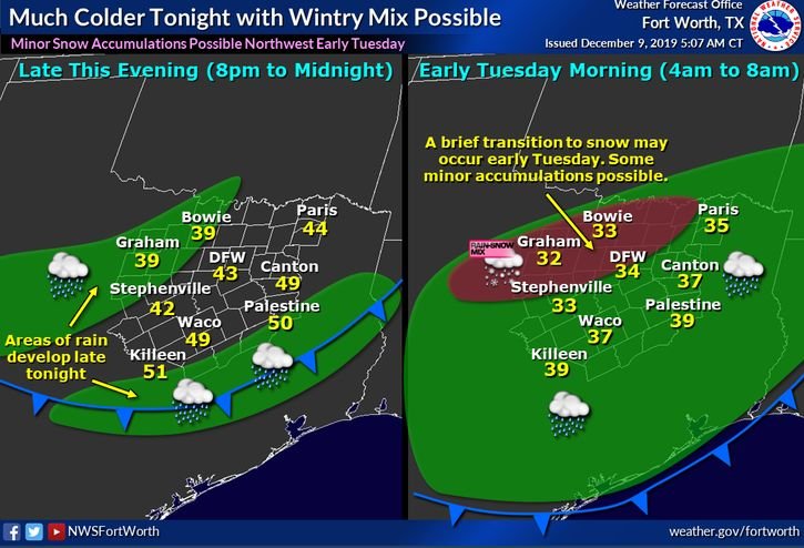
NW and W of the Metroplex I think it's certainly possible but as you get further east I think that risk drops off considerably. 12Z GFS give Stephenville and Granbury a brief shot at some wet snow overnight tonight but I wouldn't expect anything more than a coating. Western Fort Worth I think even has a slim chance to see some mixing for a brief window.
-
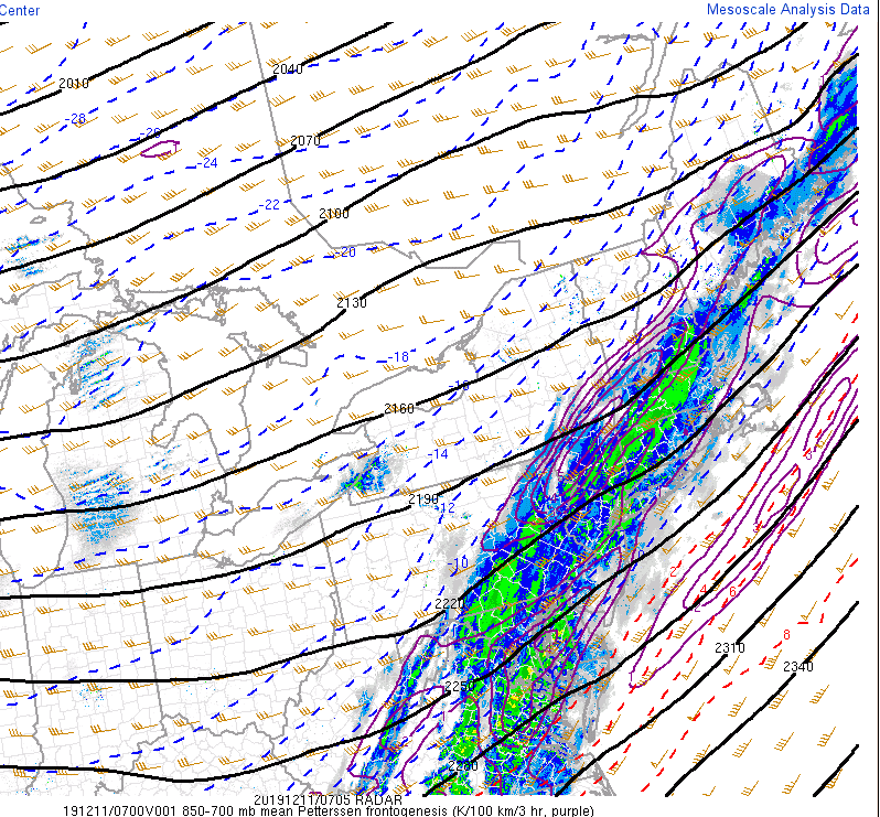
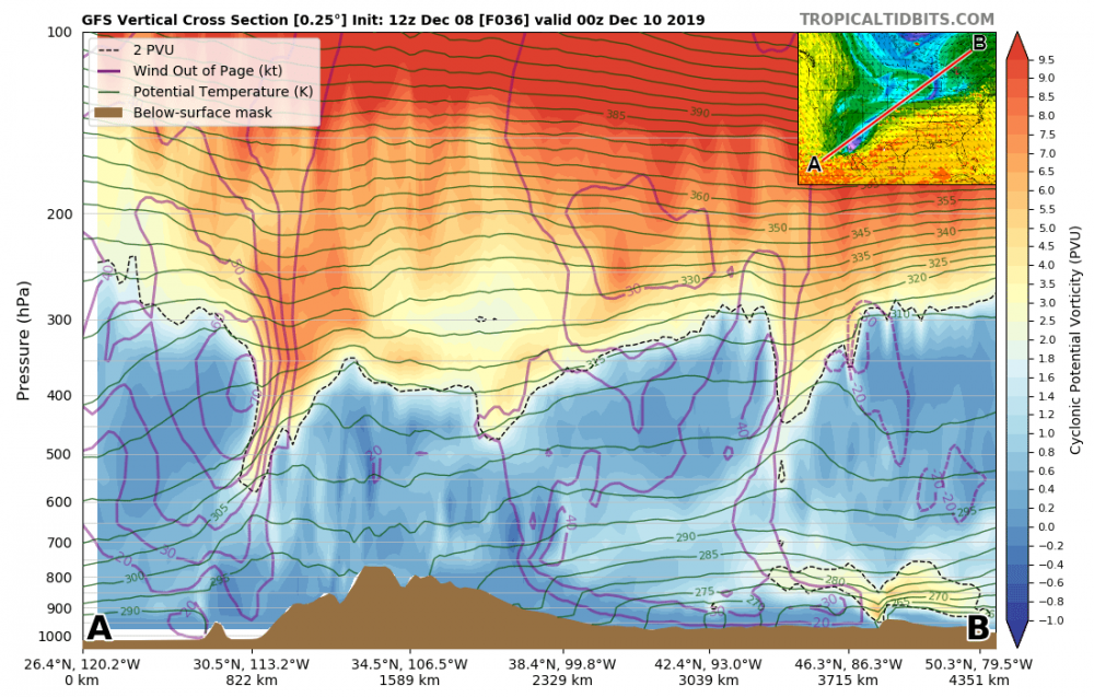
I guess there are some intrusions which may also be from PV:
-
5 minutes ago, CoastalWx said:
I didn’t look that deep, but it looks like your classic CAA with drying and subsidence at that level. Sometimes you can offset that if you can get big lift above it, but in general not a great thing to have NW winds at 850 when trying to snow. Not impossible though.
btw, message me your question you had the other day.Yeah I'll send you a PM.
I was looking at these two images which made me think that perhaps some dry air got entrained from tropo-fold. It's not my area of expertise so open to others input. It's more pronounced in images after these two but this is where it "begins" so to speak.


-
1 hour ago, CoastalWx said:
I see that pocket of dry air OceanSt and Itswayssunny refereed too. That a Bruce Willis flag if I’ve ever seen one.
It appears it may be a bi-product of some tropo-fold and that dry pocket of air translated down into the mid and lower levels. Thoughts?
-
GFS has this dry pocket between 900-700mb along E MA which I guess could suggest some seeder feeder action but with PWAT being so low looks like that may not even materialize before half of that QPF evaporates. NAM on the other hand looks potent.
-
3 hours ago, aggiegeog said:
No I think there is a good chance for snow at the end along and north of I-20. Most won't stick but up around Paris to Texarkana I could see a couple spots getting over an inch quickly. If the surface high over the Plains comes in in the mid 1030s vs the modeled 1030ish then everything shifts to I-20 or south.
Meh. If that happens precip will likely get shunted further south so it wouldn't matter. I think even if your scenario panned out lower levels will still be too warm unless it miraculously wet-bulbs to 0C.
-
I feel like there are February-esque expectations here for this month lol. Just wait until the end of January and February...CFSv2 introduces -NAO and -EPO you'll get your snow if it verifies.
-
1
-
 1
1
-
-
8 minutes ago, Snowcrazed71 said:
Several different sources that I subscribe to also show the mid-month cold coming in. So..it's not just an anomaly. What's up with all these negative posts?
Welcome to the New England forum....they want snow. And a lot of it.
-
1
-
 2
2
-
 1
1
-

MO/KS/AR/OK 2019-2020 Winter Wonderland Discussion
in Central/Western States
Posted
I wouldn't expect much more unfortunately. GEFS has that mid-level trough pretty much locked in at this point, leaving most of northern AR out of the mix but central MO could get some good snow out of this with a nice 850mb frontoband set to sweep through there.