

It's Always Sunny
-
Posts
1,946 -
Joined
-
Last visited
Content Type
Profiles
Blogs
Forums
American Weather
Media Demo
Store
Gallery
Posts posted by It's Always Sunny
-
-
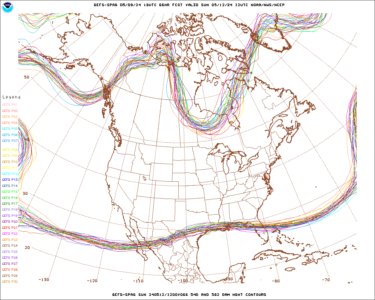
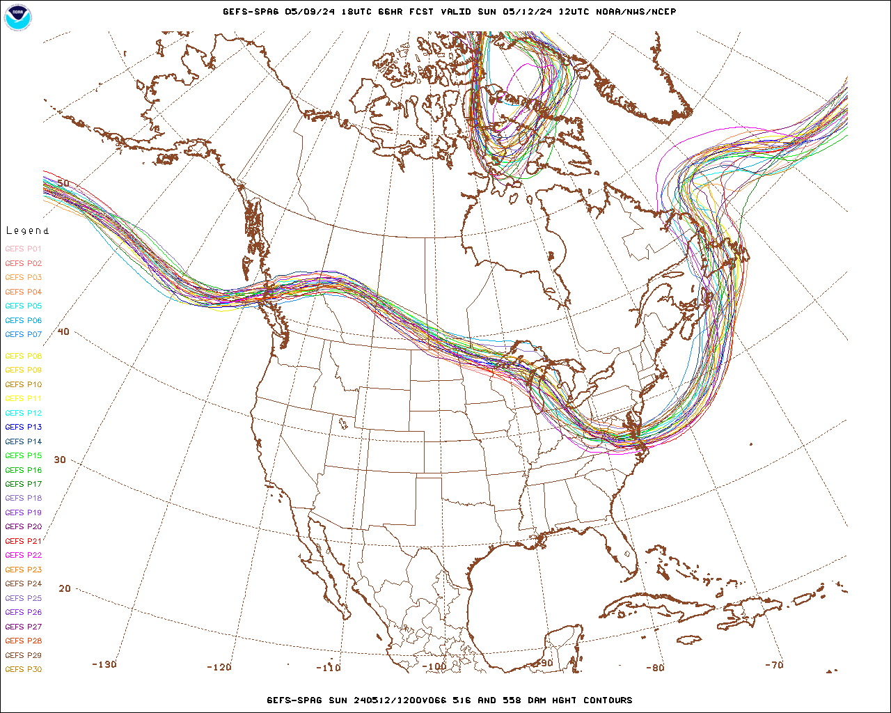
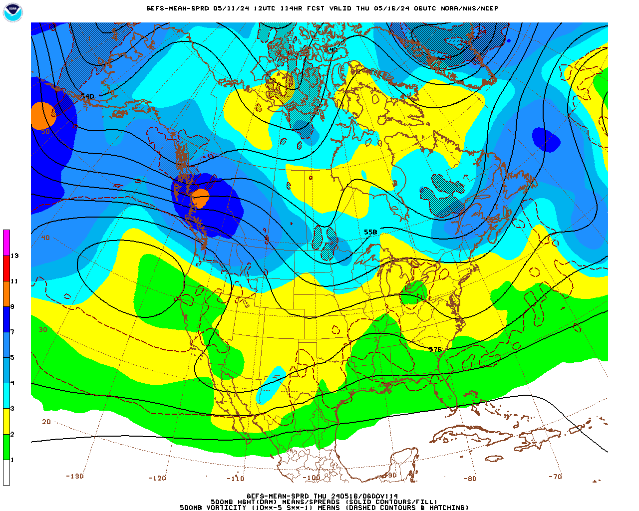
Crazy spread with that 558 DAM trough.
-
3 minutes ago, DotRat_Wx said:
For the 3rd time.... This trof is full of sh*t it ain't Happening. Don't see how it's possible. It's like a 1 in 50 chance for a moderate snow storm. Too progressive. Too much mixed up in the flow
To your point that screaming jet streak across the southeast doesn't help anyone but even if that jet streak weakens it's still very progressive flow which sucks. Banking on those two troughs to work themselves out.
-
 1
1
-
-
Trying to make lemonade out of lemons...despite the first trough digging so far deep into Mexico (which eventually becomes the s/w for the coastal), the proceeding troughs behind it which "nudge" it OTS still have lots of variability amongst them so I would think a change in the track is still in the cards:
-
Just now, ORH_wxman said:
Best thing going for this is that it does have a very well-placed trough that is fairly deep. Most of the time that spot will produce for us. On a very basic scale, we have a good synoptic pattern.
Theres obviously details that are currently preventing all systems go, but at least it doesn’t feel like we need large scale shifts in the trough position or anything like that. Airmass is marginal too but it’s likely cold enough if any meaningful precip gets in here.
I think that is what's diminishing a coastal hit though I posted earlier how the depth of that trough is actually resulting in that OTS track. If that trough weren't to dig so far south then a coastal hit would be increased unless you are referring to the nrn stream trough then disregard everything I said. The silver lining of this would be the trough digs into Mexico is not as deep as modeled. I've seen situations where models don't always handle Mexican disturbances well due to lack of data points down there.
-
5 minutes ago, ORH_wxman said:
We’ve had both NW trends and SE trends and basically no trends this winter.
The 12/17-18 and 12/28 SWFEs were pretty damned amped in the medium range and they trended colder into SWFEs. Both did tick NW really late in the game though.
12/1-3 never really came NW. It was pretty steady as an SNE/CNE special the whole time inside of 4-5 days aside from a wobble here and there.
1/6-7 didn’t come NW when we needed it...it was a big hit in medium range and then trended southeast into a cranberry bog advisory event and teased everyone the final 48 hours basically not budging during that time.
1/18 I feel like literally didn’t move for like 5 straight days. It was an advisory SWFE pretty much the entire time for almost the whole forum and never changed much.
1/25 trended 500 miles northwest inside of 84 hours...
Yeah so basically you're illustrating what I'm trying to get at which is it can't be assumed storms tick NW. It appears upstream dynamics are the driving factor in any NW trend we see unless I am missing something. Some events even went southeast, while some didn't move at all.
-
Just now, CoastalWx said:
I don't know. Not always.
He's trolling me lol.
-
 1
1
-
-
I'm no expert on this NW tick models can take sometimes but it appears it is all situational rather than an assumption. There are numerous upstream influences that can cause those. Feel free to add onto this; this isn't something I analyze as closely like some do on this board. It's something I am cognizant of but never really put assumption into it materializing.
-
1
-
-
13 minutes ago, TauntonBlizzard2013 said:
I’m not an expert.... but the gfs looks better to me
Yeah slight tick NW still east of 95/Cape Cod scraper.
-
1 minute ago, weatherwiz said:
I think it's an encouraging sign to see it back to high amplitude now...assuming with each new set of runs the pieces are being sampled better...a hedge in this direction is excellent news. The only question is will this be consistent through overnight guidance. If the flip-flopping continues then it's really anyone's guess as to what transpires b/c the end result will be too close for comfort (in terms of having to issue forecasts with leadtime) and could go either way.
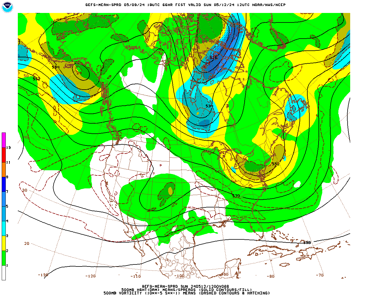
I'm just concerned with how deep that southern trough digs that's what's going to decide the fate of this storm. If it doesn't dig as much it will allow that leading s/w to develop further north to give it the track you need. Mean spreads are really low with the amplitude of that trough so that's where my cause for concern lies but model guidance also has a tendency to struggle with anything originating in Mexico so there's that to keep in mind as well.
-
1
-
-
7 minutes ago, weatherwiz said:
yeah that's a major eye opening change. You don't usually see changes that significant at this range.
What's interesting is that the GFS has been doing that for the past couple days with that s/w flip-flopping from being high amplitude to low amplitude.
-
4 hours ago, weatherwiz said:
Can't believe I missed this post!
I am thrilled for what you have had to say as it reinforces much of what I had sort of noted myself. That's also great information about the difference between top and bottom number...I think I used to use the top number quite a bit for gusts then started realizing it was a bit too aggressive so had started going with the bottom number.
What I've found seem to find with bufkit is I don't think it handles winds out west very well. Some cities I forecast for are Oakland, CA, Ontario, CA, and Carlsbad, CA and just today I saw the HWW in Ontario and my forecasts for winds are way, way, way off
It may have to do with the lack of data over the ocean which models base their grid forecasts off of. I'm not a modeler but it's just a thought because I forecast wind gusts out of the west quite frequently for other airports all over the CONUS and they verify more often than not. For the stations I forecast for in CA it's not often I have to forecast gusty westerly winds unless it's in the Bay Area which come to think of it doesn't always verify, but that may be because of what I said above, or simply because of topographical influences (which I'm leaning more towards). For SoCal, any gusts I forecast for are usually (almost always) Santa Ana related but those aren't westerly.
-
1 minute ago, CoastalWx said:
Where are the tissues
Gonna need a box of tissues for that jet streak

-
Not surprised GFS op is east GEFS has kept it east past few runs. One thing I am concerned about is the lack of spread amongst H5 around 12Z on February 1st.
-
Just missed the 6 month anniversary of the Cape Cod tornadoes. That was a fun event to dissect once it was over.
-
 1
1
-
-
EPS is allowed one swing and a miss it's been pretty consistent overall. My only concern is GEFS is also east so may indicate the start of something but I wouldn't go into full punt mode yet; still too early imo.
-
7 minutes ago, Hoth said:
Yeah Pete Bouchard blew that one badly in the Boston area as I recall. Forecasted a slushy inch, wound up close to a foot.
He had a terrible season forecasting-wise I just remember looking at his forecast with the same mindset of looking at the GEM 240 hours out.
-
8 minutes ago, weathafella said:
Firehouse special in March 2013. For the meat that is. A lot of preliminary but a hellacious 9 hour thump.
I remember that storm....lots of blown forecasts with that one.
-
I still think putting stock in the ens more than the ops is the way to lean at this point regardless of what model you look at. You know how much op models flip flop
-
Just now, Hoth said:
Wow, Scott, you ain't kidding. File that one away in the fantasy spank bank.
I can't imagine the hype that storm will draw after this one lol
-
1
-
 1
1
-
-
8 hours ago, Ginx snewx said:
Somebody missed the pivotal weather message
Yeah idk where that post was but Weatherbell has let me down 2x in 48 hrs not thrilled but it's on the company's dollar so it's w/e. Pivotal is such a great site I usually jump between that and Weatherbell. I just don't look at the Ukie enough to know who has the better graphics but I think that question just got answered.
-
Ukie is thirsty. It's wants a Miller A on draft. Unimpressive if you are coastal SNE, but not for anyone else.

-
 1
1
-
-
Save some beer for the Ukie...

-
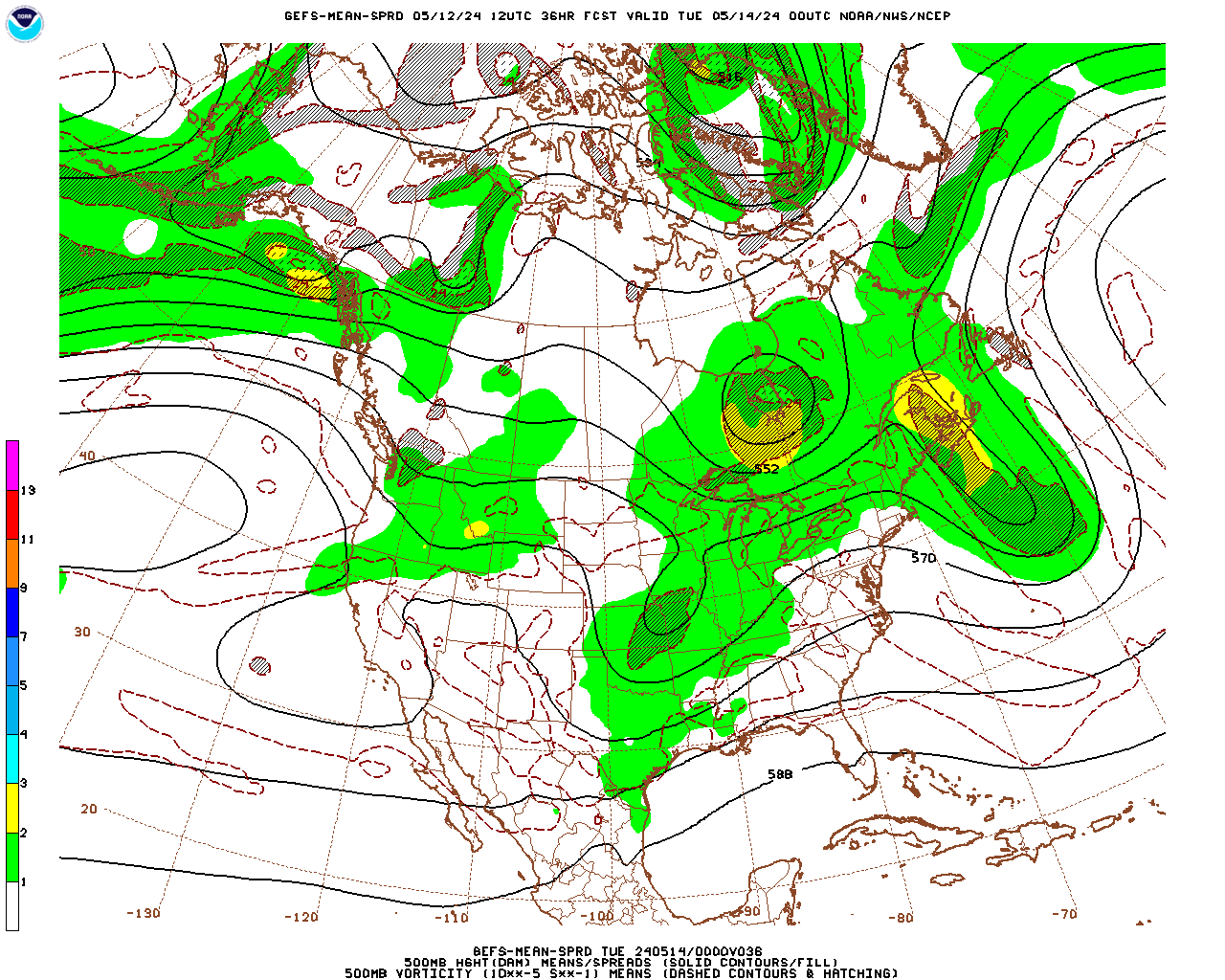
Don't want to put too much stock in anything this far out but GEFS has gotten considerably better with the location and amplitude of that mid-level trough over the Upper Midwest. Granted 12Z GFS was garbage but this is a great transition amongst mean spread plots.
-
It's also good to see all the ensembles are right around the benchmark.
-
5
-
Feb 1-2 storm threat
in New England
Posted
Precip amounts are meager as well for coastal SNE