-
Posts
667 -
Joined
-
Last visited
Content Type
Profiles
Blogs
Forums
American Weather
Media Demo
Store
Gallery
Everything posted by ILMRoss
-
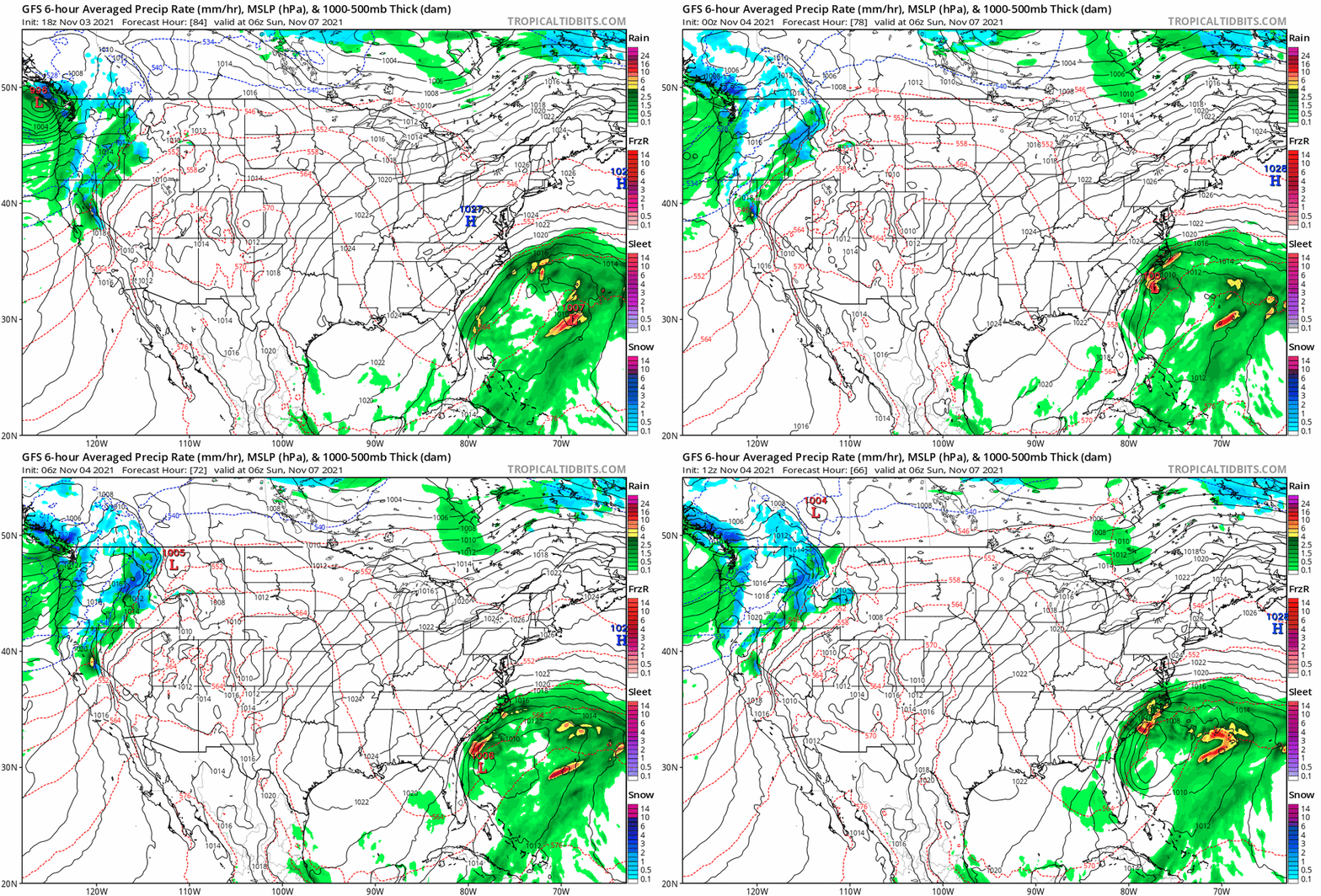
Want everyone to see this. So Nashville is getting a once in a two-three year snow today (or five year? i don't know nashville). 4 days ago the GFS had a cold, dry overcast day today. Over the course, the GFS evolved from that to the robust snow solution we see today. Just highlighting typical GFS behavior and if you ever wonder why nobody freaks out when the globals lose the storm a couple of days beforehand...this is why. I hac
-
I think this is Virginia's storm through and through, and I think that after this brutal December we should be rooting for our neighbors. I think they're in for a nice little paste bomb. After this torch stretch, we should of known a system wouldn't just fall right into our lap, that would of been way too easy!! I'm pretty pessimistic on accumulation. I usually tune the ground temps argument out but I think it has a little more merit after a historic torch. However, I think the northern half of NC gets at the very least some token flakes morning in noon on Monday. I hope it's pretty! Lastly, i wouldn't sleep on the end of the week. A little bit of juiced-up clipper potential. We still likely need some adjustments to have that shortwave dig a little more.
-
Im pretty interested to how the 00z suite handles this. This is indeed cold chasing moisture so I don’t think sticking is really on the table but there may be some token flakes as the trough passes depending on how sharp and deep it is.
-
Good grief has everyone collectively memory-holed December 2015 which to this day is the craziest month-long torch I've ever seen? This month hasn't been ideal but Christmas Eve 2015 there was a dew point of 72 in Wilmington.
-
I implore this board to do what i'm planning to do over the holidays: absolutely abuse your local municipal golf course. get your best 18 holes in. learn to hit a stinger. play two balls. go out in headphones and catch up on that audiobook. i guarantee you will have the time because there is absolutely no reason to be on this board or obsessing over the GFS unless you're trying to figure out if you can wing it in short sleeves out there or if you'll need to adorn that pullover in the late afternoon.
-
I'm actually really rooting for the west to stay troughy/stormy for a while. Don't know if everyone here has glimpsed at the snowpack levels for the west but they were really low. That region was teetering on the edge of crisis (and still in not great shape). I will gladly take a few weeks of warmth if it means the snowpack/reservoirs out west can get restored to healthier levels and we can enjoy a troughy pattern with better conscious.
-
December has always been our 'dud' month. You can certainly have events but I wouldn't weigh losing this month as heavily as losing Jan or Feb. (and that's not just anecdotal- Eric Webb put together a really nice graphic a few weeks ago showing this)
-
12z gfs says that there is no point really checking into this thread for a while unless you want to see some writhing and gnashing of teeth. see yall around christmas
-
really tough scene for the ski resorts on that last gfs run good lord
-
-
Vibe check: how we feeling? the -NAO is a lot of fun watching cut off after cut off swing through. hope we see that in january.
-
Today I wondered if my cats get thunderstorm anxiety and I realized that the reason I have to ask myself that is that Raleigh hasn’t had a good storm since when I got my cats (November)
-
I kinda made this as a little tongue-in-cheek response to this slow torture of a winter. I mean there’s a reason I called it the “Bermuda Basher”. I don’t think many people had legitimate aspirations for this storm, although I did think it had some potential. I think Webb put this really well... didn’t take much to change the game.
-
ok have at it
-
-
Let's get one blue pixel on on a clown map first
-
This is our last shot of the year. If you want one more storm to get emotionally invested in, it’s this.
-
In a winter where vortex after vortex has verified weaker and further north than what models say at this range, I’m thinking “wow, I really wish that trough in the northeast that’s suppressing this system verifies weaker than advertised” is not a hard ask.
-
That’s a great signal this far out. .
-
I think everyone is a bit worn out after this winter, which is why next weekend is not garnering more attention. I just learned about it an hour ago lol I haven’t really been paying attention. But, uh, it’s got a shot if our typical winter trends don’t show up.
-

February 18-19 MAJOR Ice Storm Threat
ILMRoss replied to NorthHillsWx's topic in Southeastern States
One thing that is completely boggling my mind is the strength of the warm nose- I cant ever remember a sleet/zr event with such a strong warm nose (10-12C, which feels completely ludicrous) - We're in uncharted territory in that regard and I am completely flummoxed on if the algorithms that govern model phase changes will be able to handle this.- 970 replies
-

February 18-19 MAJOR Ice Storm Threat
ILMRoss replied to NorthHillsWx's topic in Southeastern States
There's a reason that the NAM family initialized dew points way too high- NAM consistently has less boundary layer mixing than GFS. On a day like today when when the sun is out and updrafts are bubbling up, there will be a lot of mixing up to about 850. The air at that elevation is drier; the more mixing there is, the more dry air is able to mix down to the surface. I don't know if current dew points (RDU holding at about 26 right now) will hold or whether they will shoot up once the sun goes down, but that's why we're seeing NAM dewpoint busts right now.- 970 replies
-
- 3
-

-

-
Don’t want to get anyone’s hopes up. But as this trough finally clears the coast later this week, Friday afternoon/evening could end up being a sneaky little snow chance if our friend, the northwest trend, shows up to amp this impulse up and drive precipitation further inland.
-

February 18-19 MAJOR Ice Storm Threat
ILMRoss replied to NorthHillsWx's topic in Southeastern States
I will be interested to see how the sleet/zr transition zone resides. This is the battle of a few biases here- 1. Often models under-do the cold dome, and sleet ends up being more prominent than freezing rain. 2. I don't think these models are equipped with the thermodynamic capabilities of tracking the temperature of individual rain drops as they trek through a 10C warm nose. Will models be able to accurately get a grip on how deep the cold dome will need to be for drops to reform into sleet? Or could warmer drops hinder the ability to refreeze into sleet? Models are consistently flummoxed when phase changes get involved to the extent they are here.- 970 replies
-
- 3
-

-
This is how my power lines look outside my apartment if Raleigh gets ice it’s going to be the acc tournament before I get power back smh


.thumb.gif.012686af82f7d36d286dd94d0438f95b.gif)


