ILMRoss
-
Posts
668 -
Joined
-
Last visited
Content Type
Profiles
Blogs
Forums
American Weather
Media Demo
Store
Gallery
Everything posted by ILMRoss
-

January 20-22 “bring the mojo” winter storm threat
ILMRoss replied to lilj4425's topic in Southeastern States
He's fine. He throws enough models/jargon around to give off a "hey kid, let me show you what's really going on" kind of vibe but explains it well enough to be accessible to the public. He can be a jerk but I think people actually kind of like that schtick sometimes. But I think he generally knows what he's talking about and my Richmond friends really like him. I think every region has "their guy". For CLT it is Panovich. For a while in RDU is was Fish. For RIC I think it's DT moreso than a lot of the broadcast people simply because he's been savvy on social media for a decade now. I also like his snow map designs... Usually pretty clean and easy to read (but usually about 20% overdone lol) -
January 20-22 “bring the mojo” winter storm threat
ILMRoss replied to lilj4425's topic in Southeastern States
When the surface temps are a near lock to cooperate you can go ahead and telegraph to expect a major winter storm since sensible impacts are pretty similar across all precipitation types. -
January 20-22 “bring the mojo” winter storm threat
ILMRoss replied to lilj4425's topic in Southeastern States
Would be high quality if the Euro comes and it digs its heels in on the more amplified solution. -
January 20-22 “bring the mojo” winter storm threat
ILMRoss replied to lilj4425's topic in Southeastern States
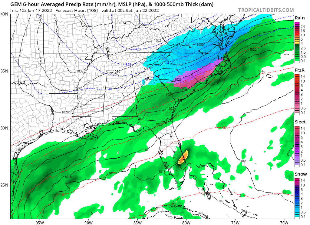
I looked under the hood and I want to couch that for a zone between Raleigh to Norfolk a decent amount of this accumulation is from Thursday night action. -
January 20-22 “bring the mojo” winter storm threat
ILMRoss replied to lilj4425's topic in Southeastern States
Going to go forth and say I don't like the Christian McCaffery model either, funny enough that northern shortwave was solidly south of the GFS but the precipitation response was much more muted in comparison. Probably some other stuff going on but you'd expect to see more expansive precip with the Canadian. -
January 20-22 “bring the mojo” winter storm threat
ILMRoss replied to lilj4425's topic in Southeastern States
One thing I'd like to add- I think sometimes everyone (mets, hobbyists, whoever) can fall into the pitfall of humanizing models too much- I see some "I trust the Euro over everything" like the Euro is a close friend you've been gossiping with, or "the GFS has been hot this month" as if the GFS is Klay Thompson. This isn't a message saying not to rely on models for known strengths and accounting for known biases- but at the end of the day every model is just a supercomputer taking in data, running it through different recipes of the same planetary laws and equations, and spitting stuff out and I think it's good not to get too caught up with the narrative behind each model. -
January 20-22 “bring the mojo” winter storm threat
ILMRoss replied to lilj4425's topic in Southeastern States
The GFS wants to bring some of the southern stream system to Cabo San Lucas and I just don't see this occurring. While most models do have this energy diving a little bit the GFS is on an island with both the strength and southerly extend of this lobe of vorticity.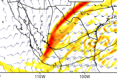
-
January 20-22 “bring the mojo” winter storm threat
ILMRoss replied to lilj4425's topic in Southeastern States
Shout out GFS this is a jolt SW with our northern shortwave just what the doctor ordered and this should be tangibly improved precipitation wise (we'll see how ptypes look).thumb.gif.9894a404225655fa0cdea44e4d5a937c.gif)
-
January 20-22 “bring the mojo” winter storm threat
ILMRoss replied to lilj4425's topic in Southeastern States
NAM looks better. I'm used to our set-ups going through a slow degradation as we go through the week. But I gotta say the speed at which we went front praying for a more amplified pattern to looking like a zr event for a lot of us really took me aback. I think that the main culprit is the northern shortwave.. see below for 12 run GFS trend. 3 days ago, that shortwave was diving into the Dakotas with a little oil and vinegar... there's been noise but you'll notice it's gotten weaker and is diving further east. Our current version doesn't dig as far, which is a lose-lose. Not only does it struggle to pop the coastal, but because it is weaker and more retreated into the polar trough, the cold press is weaker, and I think has really allowed for warmer mid levels to sneak back into the picture. I don't think over amplification is the key culprit. Sure, looks like it on the Euro, but that's the risk in playing with southern energy as the Euro currently depicts. A stronger northern shortwave in that case would bring a stronger cold press and would likely be able to throw cold water on the southern shortwave's idea of going up the coast. The NAM had an encouraging jolt westward with our energy. It may be a little late, I think "go time" is sooner than most people realize, but I think there's still some wiggle room to trend to some more positive solutions..thumb.gif.5e3b0c5d635e123a3bb319bb2ac56e97.gif)
-
January 20-22 “bring the mojo” winter storm threat
ILMRoss replied to lilj4425's topic in Southeastern States
I think that that particular site incorporates sleet/zr into the totals -
January 20-22 “bring the mojo” winter storm threat
ILMRoss replied to lilj4425's topic in Southeastern States
*sherlock holmes voice* that's meteorology my dear brick -
January 20-22 “bring the mojo” winter storm threat
ILMRoss replied to lilj4425's topic in Southeastern States
Funny thing about the CMC is that even after all that pessimism we still get a decent event. The CMC splits the two shortwave so much that the northern shortwave, less encumbered by the southern wave interaction, is able to maintain some integrity and have a better tilt. The things that stings is that this set up does not need southern stream interaction. The northern stream can get this done on its own; we need to trend with the shortwave being stronger and digging more. We're currently seeing the opposite trend.
-
January 20-22 “bring the mojo” winter storm threat
ILMRoss replied to lilj4425's topic in Southeastern States
I'll pump the breaks and say @84 never mind. Too much separation. Another event coming but it won't be a kingmaker. -
January 20-22 “bring the mojo” winter storm threat
ILMRoss replied to lilj4425's topic in Southeastern States
@54 the Canadian looks very similar to that 12z run yesterday. Our Arizona energy looks a little weaker and I think it would be easy to get it to phase with our northern shortwave. Let's find out... -
January 20-22 “bring the mojo” winter storm threat
ILMRoss replied to lilj4425's topic in Southeastern States
I'm not super duper enthused about the "second wave" because the cold appears way more marginal. Give me improvements on the first wave all day. -
January 20-22 “bring the mojo” winter storm threat
ILMRoss replied to lilj4425's topic in Southeastern States
That northern stream short wave on this run is worst its looked (weaker and ticking NE) so far. -
January 20-22 “bring the mojo” winter storm threat
ILMRoss replied to lilj4425's topic in Southeastern States
As of now yeah it's more or less overrunning. I'm sort of struggling with that "why does RDU have mixing issues in some runs" question. I'm settling on this: The "strung out, positively tilted" look is just generally no bueno for straight snow. I think there's likely some sort of destructive interference going on between the two waves that just kill them both and cause the general trough complex to slow and stall. If they stall, lower heights can never really press into the Carolinas and we're just simply left with warmer mid-level air. No crazy dynamics overamping stuff going on, we just would't be able to cool those mid levels sufficiently in that spot. I do think that the surface cold press is here to stay. Crazy cold air masses can and do undercut warmer mid level air, i mean, how do you think places like Missouri get ice storms? -
January 20-22 “bring the mojo” winter storm threat
ILMRoss replied to lilj4425's topic in Southeastern States
To me, I think that the battle lines are set today. Going to use the Canadian from last night because it's a good example of our "dudes out on the field". The northern energy drops in from the plains. We want this energy to be stronger and nudging further to the SW; our dud runs are when this trough stays too positively tilted and just can't get anything to pop. The southern energy comes from Cali/Arizona and we want it to be quicker; our dud runs come when it's held back. It's a shame that we have to deal with this because Baja/Mexi lows have the predictability/reliability of orange cats (you know the type). So far it seems a host of solutions are on the table. The runs where the Zona shortwave is held back make this plains shortwave dominant and we just have to hope it is digging enough/strong enough to pop something. The runs where the Zona energy kinda mingles with our northern stuff (saw this with Canadian) will be murky. The end product would depend on how cute the models get with fluid dynamics but generally it looks like the trough would be large/south enough to bring some good moisture transport but positively tilted/sheared enough to cause ptype issues. 1.28.2014 is the obvious analog here. The runs where the Zona energy comes together in melodious harmony with our northern energy (yesterday's 12z Canadian) would be iconic southeast winter events. Famous last words here but the surface temps shouldn't be an issue with this cold press.
-
January 20-22 “bring the mojo” winter storm threat
ILMRoss replied to lilj4425's topic in Southeastern States
Canadian shortwaves ended up getting modeled out of sync, these need to be together. Shows the potential we have that even with this we still pulled off a moderate event.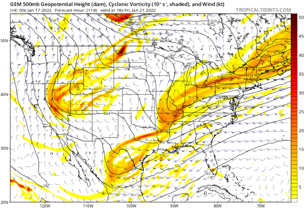
-
January 20-22 “bring the mojo” winter storm threat
ILMRoss replied to lilj4425's topic in Southeastern States
Canadian looks like it's going to be a treat, similar look to 12z at hour 96 -
January 20-22 “bring the mojo” winter storm threat
ILMRoss replied to lilj4425's topic in Southeastern States
There are minor difference so far on the Canadian through hour 78 but so far it looks like it could be similar to the 12z. -
January 20-22 “bring the mojo” winter storm threat
ILMRoss replied to lilj4425's topic in Southeastern States
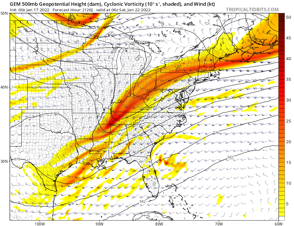
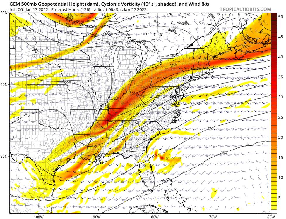
@120 Boom!!!! Snowing across the entire Carolinas with heaviest at the coast... what a run!!! Edit- let me couch this by saying the snowmap won't look incredible yet but the GFS took a huge step forward -
January 20-22 “bring the mojo” winter storm threat
ILMRoss replied to lilj4425's topic in Southeastern States
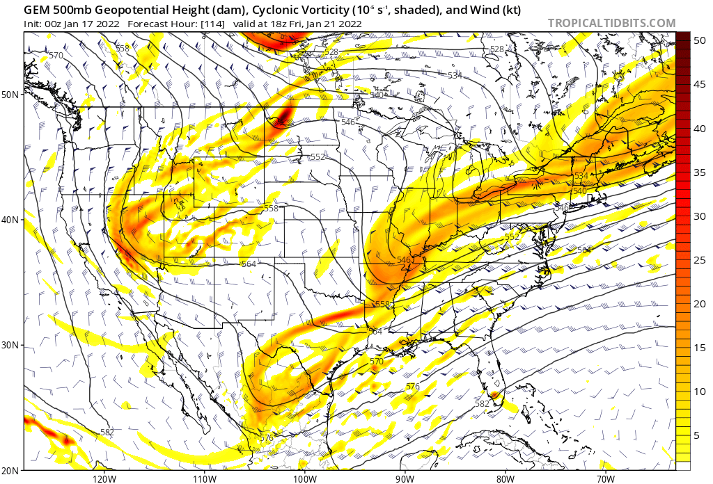
@114 Snow breaking out across central GA, SC and coastal NC... much healthier run -
January 20-22 “bring the mojo” winter storm threat
ILMRoss replied to lilj4425's topic in Southeastern States
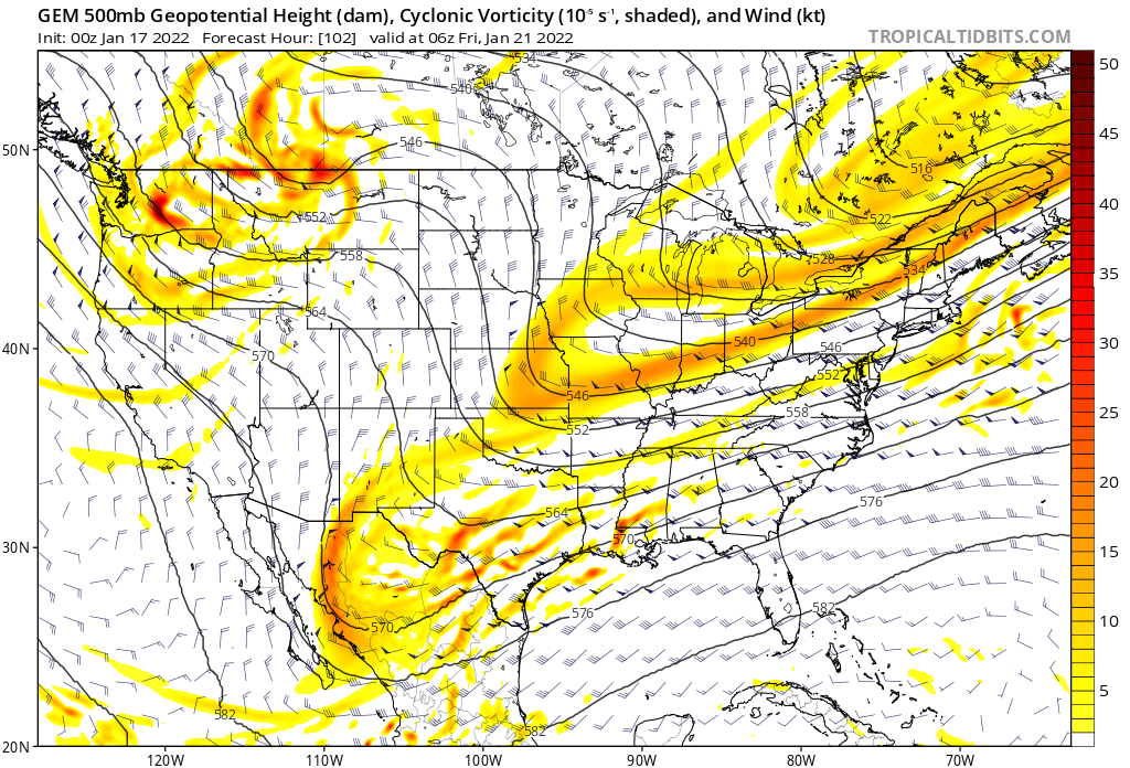
At hour 90 500 mb setup looks way different... that southern energy is much more consolidated... could be a big run...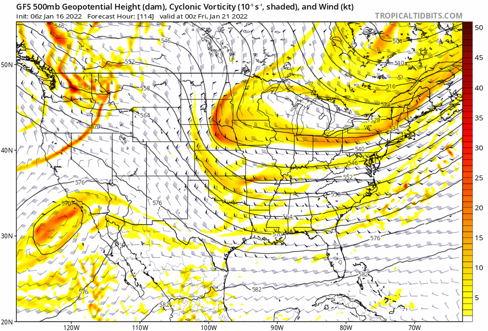
-
January 20-22 “bring the mojo” winter storm threat
ILMRoss replied to lilj4425's topic in Southeastern States
ICON with a healthy NW jolt. itshappening.gif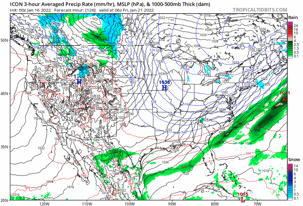


.gif.18e9b809fe2763ef1388e45ddb460829.gif)

.gif.c608dfb56eea2ab695d491a1658629c4.gif)