

Upstate Tiger
-
Posts
720 -
Joined
-
Last visited
Content Type
Profiles
Blogs
Forums
American Weather
Media Demo
Store
Gallery
Posts posted by Upstate Tiger
-
-
I posted in obs that it was 47 this morning in West Lincoln County. Pretty amazing to be less than 5 weeks from July 4. Love it. Pic from last evening sitting on deck waiting on deer. Almost needed a sweater.
-
 5
5
-
-
47 this morning in West Lincoln county. Wow.
-
2
-
-
Probably just click bait but at least something to read during these rainy spring days...
https://www.einpresswire.com/article/685988510/2025-winter-outlook-united-states-and-canada
-
For a 40% chance of rain, there sure was a lot of thunder, lightening, and flooding over the last 4 hours.
-
1
-
 1
1
-
-
3 hours ago, NorthHillsWx said:
It looks quite dry over the next two weeks. 12z Canadian actually doesn’t have any rain for central NC through the entire run. Quite the change for the mid range compared to last few days
Let Nina begin.
-
1 hour ago, Snow dog said:
Here’s how bad it’s been for the SC folks…
https://wyff4.com/article/south-carolina-only-state-no-snow/46860399
We should never have been the ones to start the Civil War. I knew it would catch up to us one day.
-
 1
1
-
-
1 hour ago, CAD_Wedge_NC said:
I am 60 years old, and I remember the Feb 1969 storm. 16 inches of powder. I was just a kid, but the snow was up to my knees. Also has thundersnow for a few hours in the afternoon.
I’m 59 and I remember knee deepers in March of 71 and February of 79. Some other notable ones were January 87 and 88.
-
38 minutes ago, Chuck said:
My biggest snowstorm was Nov 25 Thanksgiving 1971 snowstorm while living at the end of the Pa turnpike in Clark's Summit, Pa. Forecast the day before was dusting increasing to 1" at 3pm. Went to get hoagies for family around 5pm and we're up 2"-3". Sent to bed with forecast now 4"-5". We had our rivalry high school football game played on Thanksgiving. I got up to use bathroom and mom was already up starting Thanksgiving dinner. She heard me and said she didn't think that they'd be playing the game. I got back to bed and she called in my bedroom saying that the game had just been postponed. I said for a couple of inches of snow? She asked if I had looked outside. My dad's car was in our drive so his dad could park his car in our two car garage while they visited... or at least it was supposed to be in the drive. Snow had drifted over it to the tune of about 2' on the ground. Wind was blowing hard all day and think we wound up with 3' or so. I missed the game by having to go back to college.
From https://www.freightwaves.com/news/worst-thanksgiving-storms-in-us-history
Northeast snowstorm Nov. 25, 1971
The night before Thanksgiving in 1971, snow began to fall in parts of the Northeast, including Pennsylvania. The snow became more intense throughout the night, and by the afternoon of Thanksgiving Day, snow totals across the state ranged from 20 to 30 inches. The biggest amounts piled up in northeastern Pennsylvania, but Albany, New York, also got slammed, with a snow total of 22.7 inches.
This was extremely wet, heavy snow, as temperatures through much of the storm hovered around 31 degrees. If temperatures had been lower, the snow would have been drier and lighter. The weight of the snow caused barn roofs to collapse, snapped off tree branches and knocked down power lines.
Cool story. Thanks for sharing. That’s the thing about big snowstorms, especially in the south, is we can connect them to some special people and times in our lives.
-
I hate you youngons missed some of the monsters from the 70s and 80s. 93 is in a category of its own though.
-
1
-
-
5 hours ago, Met1985 said:
You've done a wonderful job Larry. Very much appreciated.
Very disappointing winter for sure. Thought we’d get at least 1 event. Hopefully this summer is not a dry scorcher.
-
2
-
-
CPC predicting rapid return to Nina conditions this summer and increasing through fall. That makes 4 out of 5 right? Can we ever get a neutral anymore?
-
8 minutes ago, BooneWX said:

LOL...I had this copied and ready to paste!
Love seeing the purple over the SE...
-
 2
2
-
-
17 minutes ago, SnowDawg said:
That pesky low in the lakes look we've seen a million times in the last two years. Need that northern stream energy to either dig a lot more SW and phase with our system, or just not be there at all and allow the highs to bridge over the top and give us more of a CAD look out front.
We won in Chapel Hill last night for the second time in 62 years. At this point, I believe anything is possible.
-
2
-
 2
2
-
5
-
-
12 minutes ago, StantonParkHoya said:
Sir, beyond 10 days is spring
Wished you were right. Has been no time fittin for golf on the weekends since November but it looks like plenty of cold to me.
-
16 minutes ago, NorthHillsWx said:
Jack Campbell there is no arctic air on the way and no winter set-up. The cool anomalies are caused by rain and clouds, not cold air. Thats why it's so warm north of the storm track.
Michael Berger no signs of that at all, all the cold air in on the other side of the hemisphere in the long range.
When you see crazy maps with departure from average temperatures for late February, you must remember what average is. 10-15° below average in the Feb 15-25 timeframe still puts us in the 40s. It's not cold enough for winter weather. #cltwx #ncwx #scwx #wcnc
Quotes from Brad P on his post
That analogy certainly makes sense and I do not get paid to forecast the weather.
However, looking beyond the 7-10 range looks like there is plenty of arctic air in Canada, northern tier, and this side of the hemisphere.
Guess I am a little puzzled what he is looking at to completely call off winter?
-
1 hour ago, eyewall said:
I can't buy in at 300 hours.
That's all we've got ATM.
It's kinda like at the end of the night when you know the bar is going to close soon and the only girl left in the place is one who looks pretty good sitting way down at the other end of the bar.
-
1
-
3
-
-
This winter really blows. Can't believe we are going to be shut out again. It's never going to snow in the SE again.
There, that should help.

-
2
-
2
-
-
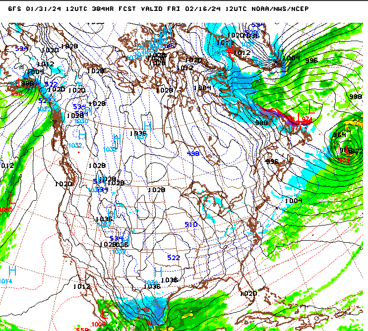
2 hours ago, GaWx said:
Per the latest model consensus, there’s a very good chance that the PNA for the 2nd half of Feb (2/15-29) will average +0.5+ and the AO will average sub -1. The following El Niño 2nd half of Febs met both of those conditions:
1988, 1983, 1978, 1977, 1970, 1964, 1958
So, during 1957-1988, 7 of the 13 El Niños met both of these. But interestingly the subsequent 10 didn’t. So, 2024 would be the first of the last 11. How did those 7 last half of Febs play out at RDU in terms of temperature anomaly and snowfall?
1988: -3/0.0”
1983: -3/0.4”
1978: -11/5.6”
1977: -3/1.5”
1970: -7/T
1964: -9/2.0”
1958: -9/3.0”
AVG: -6/1.8”
So, temps were BN 4 times and MBN 3 times. Snowfall was AN for all 3 MBN temperatures and BN for 3 of the 4 BN temperatures. The average was BN for temperatures and AN for snowfall.
78 and 83 were pretty memorable in the upstate of SC
-
1
-
-
71 forecast here for Super Bowl Sunday. Maybe we'll finally get some decent weather for our annual Super Bowl Sunday backwards par 3 tournament. May have to break out shorts and sunscreen.
-
LOL...The Rio Grande, Corpas Christi, and South Padre Island are the places to be!
Plenty of time for this to trend north and east
")
-
1
-
4
-
-
1 hour ago, PackGrad05 said:
6z GFS has three opportunities. Fun to see. May be gone by 12Z.
.In all seriousness I think we will start seeing fantasy storms showing up over the next several days for this period.
-
2
-
-
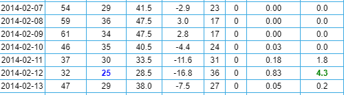
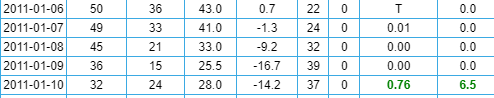
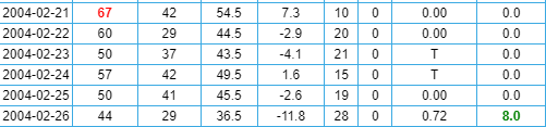
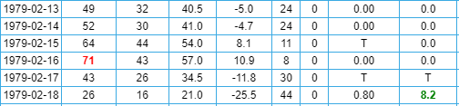
There's been some talk about the correlation and timing of cold in the SE to winter storms. Just for fun, I went back and looked at some memorable winter storms to see what temps looked like in the days leading up to these storms. This is for the Greenville, SC area. The far right column is new snow depth. With the exception of 1982, the cold air arrives within 24 hours of the onset of the storm.
February 2014
January 2011
February 2004
January 1996
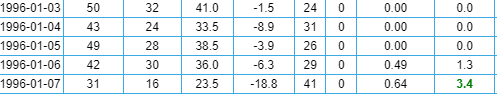
March 1993
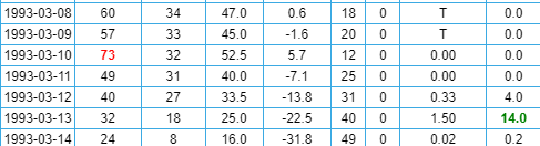
January 1988
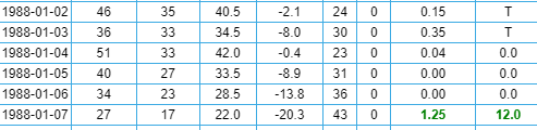
January 1987
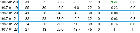
January 1982
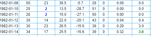
March 1980
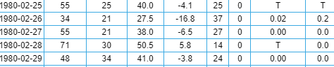
February 1979
-
6
-
2
-
-
52 minutes ago, Brick Tamland said:
Pretty desperate if we're already talking about March. I don't believe there's a chance of any winter weather here past February.
Brick. Have you tried to play golf in March the last few years? I swear I saw that mammoth from Ice Age walking across the 6th fairway last year. Good to hear from you BTW.
-
48 minutes ago, NorthHillsWx said:
Also that 28-30th time period would favor a cold source in New England vs the Midwest. Much more favorable around these parts. At least something to watch
Agree. Orientation of the cold in February is much more conducive to winter weather on this side of the apps. Of course it changes every 24 hours which is probably a good sign.
-
1
-


Mid to Long Range Discussion ~ 2024
in Southeastern States
Posted
I think you make some valid points. I have been closely following the winter weather in this area since 76/77 when I was 12. There were some epic winters from 76/77 - 82/83. After that, it seemed winter storms became less frequent throughout the remainder of the 80's. Yes we had the epic cold snap in January of 85 and the big dogs in Janaury of 87 & 88, but that was about it. I kept thinking this is just a pattern change like the 50's and it would snap back like it did in the 60's. But, it didn't happen in the 90's either. We had the Super Storm in 93. 95/96 was very reminicent of the "old pattern" Anyway, the climate, as it always has, is changing and is not the same as 50 years ago.