

Upstate Tiger
-
Posts
720 -
Joined
-
Last visited
Content Type
Profiles
Blogs
Forums
American Weather
Media Demo
Store
Gallery
Posts posted by Upstate Tiger
-
-
1 hour ago, NorthHillsWx said:
Kinda feels like we’ve got one shot left. We burn that first week in February we are definitely running out of time
Yeah, I hear you. If you look at the long range link I sent today, and I'm not the expert others are, it would seem to me maybe the 5th, which is start of week 2, would be the earliest for a true pattern change. However, winter is a fast flow so things can change fast.
-
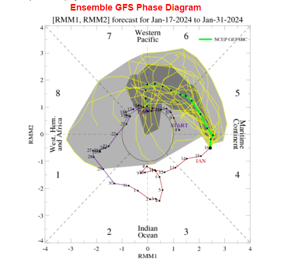
Looking at the long range out 14 days to first week of Feb., the cold in Canada looks better today and looked even better overnight. NAO looks to stay positive but so does PNA. MJO looks to maybe get through 6 and some plots have it going into 7. Still feel like we get our chance in February.
https://www.cpc.ncep.noaa.gov/products/precip/CWlink/pna/nao_index_mrf.shtml
-
 1
1
-
-
Welp. This season started with such hope. Maybe ranking among the best of all time. 79-80 and even 95-96 were mentioned when talking about this year.
However, we’re headed into late January and we suck again having lost 4/5. Oh and this winter sucks too. Hoping for that February turnaround and great March for both.
-
1
-
-
Looking at the longrange on the 12Z GFS today is not good for us snow lovers in the SE. Any cold intrusions after this weekend look sparse going into the first week of February. Remains to be seen if the cold returns as moldeled earlier. NAO looks to head positive, PNA stays positive (good), but MJO is headed to 6 before maybe COD. Not the trends we want.
-
7 minutes ago, NorthHillsWx said:
Fixed it for you
")
No one expects wall to wall cold, that’s not the problem. It’s purely that we simply haven’t had many cold shots and have had well fewer than normal opportunities to track since December 2018. We just spent 2 months discussing a pattern change that led to this week which clearly wasn’t the cold outbreak we expected. With 70’s showing up next week and the next chance at wintry weather looking like February at the earliest, it’s pretty safe to say that 2/3 of our best wintry months will have been wasted. And before anyone tells me it can snow in march, I DO NOT CARE. Banking snow in march is like playing the lottery here. Heck, in our new climate, past Valentine’s Day seems almost impossible. If this was year 2 or 3 of the snow drought, yea I’d be gaslighting. But year 6 and this is feeling like less of a drought and more like the new norm. It sucks but that’s where we are at
Yep. It stinks. Snow drought is probably an appropriate term. The 1950s had a similar snow drought in the SE. Still think Feb holds some opportunities
-
I know it's frustrating right now and it's been a frustrating couple of years for snow lovers but wall to wall cold from December to March just does not happen here.
The coldest month on record at GSP is Janaury 1977 and there were days in the 50's and even a 55 on Janaury 27.
The coldest February on record at GSP is February 1980. We had 8" of snow that month with 3 events. We also had 4 days in the 70's including a 76 a few days before March 1, 1980. Anyone around the Carolinas then remembers what happened March 1-2, 1980.
-
During the moderation the last 2 weeks of the month (hopefully get some golf in), Canada will be resupplying with cold air. I actually liked the orientation of the high pressure better on the 0Z for the first week of February. The 06Z was further west. Nevertheless, cold should be poised to move south and east.
-
1 minute ago, BornAgain13 said:
18z GFS has caved to the Euro. Dr. No is back.
Sent from my SM-N981U using Tapatalk
Yep. The 18z is no bueno for Monday and Tuesday.
-
I guess I need to go back and look at the 12Z GFS again because I don't get the gnashing of teeth
 . But I'm old so I may have been looking a tic tok video.
-
2 minutes ago, SnowDawg said:
GFS Ensemble favors suppression at the time which is not a bad place to be. Don't wanna be in the bullseye yet.
Correct! That's the place to be in this set up.
-
1
-
-
GSP AFD...
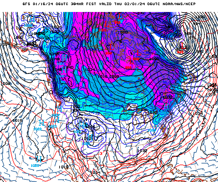
 Extended models show the
development of a long wave structure with a deep upper trough over
the eastern CONUS with numerous chances for shortwave passages
through Wednesday.  This pattern also gives generally lower
thickness levels and increased chances for snow over the GSP area
through Wednesday.  Moisture is still limited.  Still the EC model
has some snow over most of the CWA on Tuesday.  The GFS model,
however, restricts frozen precip to the higher elevations.  Overall,
chances for winter conditions increase into mid next week, though no
major event is current on the horizon.
Yeah but I want a major event!!!!
-
1
-
-
Weather app now saying 22 MPH sustained with 50 MPH wind gust at my home in Cherryville. Just looking at doorbell cam it is hard to validate. If valid, there will be major power outages. Very windy at the hopital here in Gastonia.
-
Weather app says 21 mph sustained and 49 mph gust at my home in Cherryville. Got to say though that my doorbell camera doesn’t look like it’s blowing that hard. Going to be a wild day. Stay safe.
-
2
-
-
GSP's morning AFD on next week'sa potential event. The forecaster put is about as good as you could...
 An
interesting set up is showing up in guidance by D7, but still a
lot more questions than answers this far out before going into
the nitty gritty details as differences between model guidance
suggests they don`t know what the heck is going to happen with
the sensible weather beyond this upcoming weekend. Temperatures
are expected to begin the period at or slightly above normal on
Friday before below-normal values settle in through the rest of
the medium range following Friday`s system.
-
1
-
-
Well there will be a big storm in the south it looks line. Right now Tenn forum should be happy. We’ll see if that holds over the next several days. My guess is it moves back and forth until Friday or Saturday.
-
In January of 1977, I believe it was 16th and 17th, we had a very similar set up as this. Cold on the front end allowed for a little frozen in the higher elevations. Then heavy rain, high wind warning, and even a tornado watch.
When I went to bed that evening, the temp at GSP was 66. Winds howled all night with some stations reporting 80 MPH gusts. When I got up, we had a dusting of snow blowing around and temps in the 20's. About 8:30 AM a snow squal came through with absolute whiteout conditions.
Temp dropped to 19 degrees and stayed there all day. We had occassional snow flurries in the upstate all day and the winds were gusting to 50 MPH. Wonder if any of you other boomers like me remember that one?
-
32 minutes ago, SnowDawg said:
16th/17th was really close and certainly not a bad look 9 days out. Ensemble actually has a suppressed look for that storm at the moment.
Yeah. This period is worth watching. We’ve got cold coming and an active jet stream. I really don’t want to be sitting in the jackpot zone outside 7 days. We all know how that works out. I also think the warmup will be muted and short lived.
-
2
-
-
5 minutes ago, JoshM said:
Clouds started rolling in , I've went from 32 up to 35 in last 2 hours
We’ve been stuck at 34/26 for last couple of hours. Wished I could stay up a couple more hours as I think we get a few flakes and some sleet before WAA takes over.
-
1
-
-
Temp falling like cheap lard in Cherryville. Down to 36/27 at 643. About 5 degrees colder than prog’d. Hmmm
-
1
-
 1
1
-
-
2 hours ago, Coach McGuirk said:
Hope is perpetually 2 weeks away.

-
 8
8
-
-
41 minutes ago, wncsnow said:
Mostly yes.
The Pacific looks like its not going to cooperate. Will have to rely on HL blocking IMO.
-
2
-
 1
1
-
-
56 minutes ago, NorthHillsWx said:
Lots of CAD possibilities but we just cannot time any right with a HP for anything substantial per current modeling.
Ops not showing anthing to hang our hats on but with active pattern, arctic air in our hemisphere, blocking posibly showing up, who knows? It only takes one

-
1
-
-
Looking at the last 24 hours of model runs leads me to believe the next 2-3 weeks are going to be a wild ride.
-
 1
1
-
-
38 minutes ago, strongwxnc said:
Most likely on an island but Im heading to that island for now
")

-
1
-
2
-
2023-2024 Fall/Winter Mountain Thread
in Southeastern States
Posted
Awesome pics guys!! Keep sharing. And give us some temp updates too.