

Upstate Tiger
-
Posts
545 -
Joined
-
Last visited
Content Type
Profiles
Blogs
Forums
American Weather
Media Demo
Store
Gallery
Posts posted by Upstate Tiger
-
-
1 hour ago, buckeyefan1 said:
It's soooooo close to being everything we are looking for. Sigh. Maybe I need to ask my witchy friends to come over for a winter fun ceremony and banish that depressing death ridge


Looking at the models for the next 2 weeks, Jan. 2 thru Jan. 6 is about the only period I see a slight chance for something frozen in the SE. During that period, there is cold air in the Midwest, the NAO remains negative, and the PNA relaxes a bit. I know...I am grasping at straws LOL.
-
The super cold air in central and western Canada looks to be on the move south after New Years. How far south and east it goes is the question. At least we have cold air on this side of the hemisphere. Any buckle in the jet stream will open the flood gates.
-
I caught a bit of the news tonight and it’s heartbreaking to see what our neighbors in Kentucky and the other states are going through. Kinda hard to root for a pattern change that would bring more misery to those poor people. For once, I’d be happy to see above normal temps and no precipitation.
-
 4
4
-
 1
1
-
 1
1
-
-
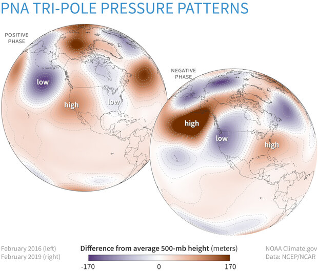
NAO forecasts continue to show negative trends after next weekend while the PNA shows positive trends during the same time. May just be a temporary trend or signs of a real pattern change. At this point, it's about the only thing SE winter weather lovers can hope for...
https://www.cpc.ncep.noaa.gov/products/precip/CWlink/pna/nao_index_mrf.shtml
-
35 minutes ago, buckeyefan1 said:
Seriously though, with 4 out of 5 being favorable we might get the pna to at least be neutral. Or not. I do however believe the pattern shifts around Christmas. Will it shift in our favor? We'll find out soon enough. Until then, I will believe in southern snow, unicorns and faries

Yes. If we could just get the PNA to move to neutral, I think we could see some opportunities in the south. There are some subtle signs that the PNA is moving toward neutral after next week. Will it get there? Who knows?
-
2 hours ago, lilj4425 said:
So what you’re saying is I need to go to Maine or Miami to see snow.
Or Seattle or San Diego.
-
Forecast to be below freezing each morning for the next 10 days IMBY. That will get rid of what bugs remain. Unfortunately, it looks dry. Very Nina like...
-
Looks like mountain peeps get some November accumulating snow Wednesday night and Thursday.

-
2
-
-
4 hours ago, wncsnow said:
The Canadian is showing some love

The first snow map of the season. Awesome!!
-
2
-
-
Looks like some could see their first freeze next week. NAO looks to continue in negative territory where’s it been for a while but the PNA is heading back down also.

-
39 this morning. Our first morning in the 30s here in the western Piedmont. 66 this afternoon. Great day to be outside.
-
Nothing much in the long term to indicate our first frost in the SE before at least third week of October. However, in a shocking development, the west is progged to be much below normal over the next two weeks. Maybe this signals a reversal in winter fortunes this year. Last year I remember taking some cold rides in October and November.
https://www.cpc.ncep.noaa.gov/products/predictions/threats/threats.php
-
2
-
-
Read where the CPC is predicting 70% chance of weak La Nina from November through January. Weak La Nina's, generally speaking, are much better for the southeast than moderate or strong La Nina's. Years with weak LN's that produced bouts of wintry weather in the Southeast include 95/96, 83/84, and 00/01. Interestingly, 10/11 and 84/85 were moderate LN years and those were pretty active winters for the SE. Who knows. Not sure what I will see next...A SE snowstorm or a Clemson touchdown.
-
6
-
-
I am by no means the ENSO expert some on here are but it seems there is significant cooling in the 3.4 region of the pacific which would indicate another La Niña for late fall through winter. CPC has issued a Nina watch. Last winter was frustrating for winter lovers in the SE. It seemed the plains, Midwest, Tenn Valley and even mid Atlantic and NE had significant winter weather while we were under the curse of the SE ridge. Hopefully there is no repeat for this winter.
-
Left Myrtle Beach at 1130 AM and drove home to Cherryville. Temps were 92 or 93 from Florence through Hartsville, Pageland, and Lancaster. Rose to 95 in Rock Hill. That was highest I saw all day. Arrived home around 330 PM. It was 91 here in Cherryville.
-
12 minutes ago, tarheelwx said:
It’s a really warm snow I believe. 32 or so. I’d really like a legit, decently cold storm. Just something under 30 would be nice.
TWHaven't you heard...it only snows now when it is 34 degrees F or higher
")
-
3
-
-
2 hours ago, chris624wx said:
00z Euro wants to have some fun with the late week storm now too!


-
4
-
-
7 minutes ago, kvegas-wx said:
Totally agree, but I think you would also agree to approach this forecast with some skepticism. Nothing has worked out this year as modeled. Both temps and QPF forecasts have proven to be quite unreliable. If our winter trends hold we will end up with an event like we had over the weekend. If the models bust in the wrong direction this time, then yes, generational will be an understatement. I'm going to be leaning heavily on the HRRR and ICON again on this one. The NAM isn't screaming warm nose as much as it was previously, so I'm crossing my fingers that 75% of what falls in the Triad will be sleet. Time will tell.
Your comments about the NAM should be bolded. Ignore the NAM from here on out at your own peril. I've been burned too many times trusting other models when the NAM is the king of warm nose forecasting.
-
1
-
-
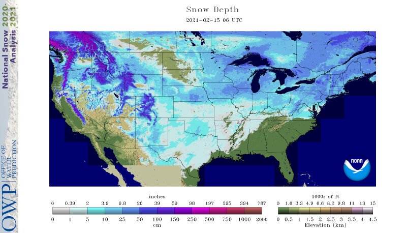
I know this is salt in the wound to many but below is the US snow cover map as of 06 UTC 02/15/21. It shows 70.49% coverage. Will likely increase today as Mississippi and Tennessee fill in more. This is historical territory. Previous record is 70.9% on Jan 12, 2011. 1966 and 1978 also were in the 70% range.
-
1
-
4
-
-
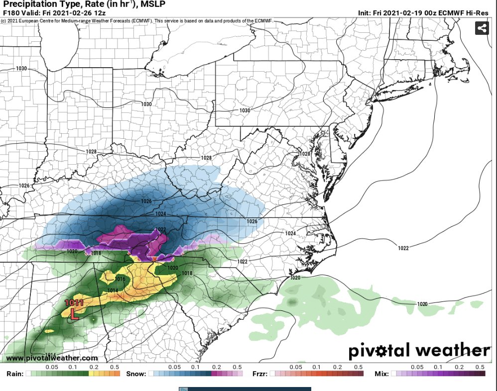
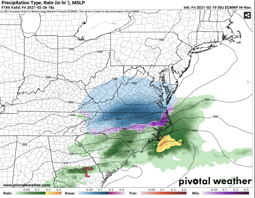
I know it's been a frustrating weather week in the SE, especially when Dallas is expecting blizzard conditions Monday morning. There could be snow covering most of the U.S. next week except the SE and southern half of the West coast. However, another round of anomalous cold air builds in Canada the last week of the February and is poised to move south. I am not predicting another March 1980 storm but as crazy as this year has been, I wouldn't bet against anything at this point. Heck, I am not even confident with what falls from the skies next Wednesday and Thursday.
-
32 degrees this morning in Cherryville. Apparently we had some geographical upheaval overnight. Always wanted live in the mountains
-
1
-
-
4 hours ago, BullCityWx said:
PDII was very weak as well
Actually meant 960MB for the the 93 storm.
-
1
-
-
47 minutes ago, Orangeburgwx said:
Who would have ever thought we would need a weaker low to give us wintery precip...
Sent from my LGL322DL using Tapatalk
Depends... President's Day 1979 was a 996 MB low with a 1050 high over the Great Lakes; the March 1993 Superstorm was a 990MB bomb with wind gusts over 140 MPH.
-
For those who haven’t looked, GSP seems about as confident as everyone else
just went out and put a little gas in my generator that I bought during the December 2005 ice storm. Started right up with one gentle pull. Tuesday morning at 200AM when it’s freezing rain and 27 degrees, 10 mules won’t be able to start it!

Mid to Long Range Discussion ~ 2022
in Southeastern States
Posted
Looks like winter pulled a UCLA in December and decided not to show up.