

Upstate Tiger
-
Posts
545 -
Joined
-
Last visited
Content Type
Profiles
Blogs
Forums
American Weather
Media Demo
Store
Gallery
Posts posted by Upstate Tiger
-
-
58 minutes ago, GaWx said:
Fwiw, the 18Z GFS, like the 0Z, has what may be a real live major SSW on it late in the run fwiw. For those curious, check out the N Hemispheric maps at 10 mb late in the 18Z/0Z GFS runs to show what I'm seeing. They show a significantly displaced SPV along with massive Arctic strat warming. These are both bordering on a 60N wind direction reversal from W to E, especially the 18Z.
I swore this winter if I caught myself relying on SSW, I’d throw in the towel but here I am!
GW is that the reason we’re seeing those crazy HP readings in Canada on the GFS starting mid-month? I’m seeing highest I’ve seen all winter.
-
 1
1
-
-
I know, I know, why keep torturing myself with hope?
-
One thing that is consistent on the GFS runs is really cold air dropping back into central and eastern Canada just prior to mid February after our warmup. It would only take a slight buckle in the jet stream to bring it south. Wouldn’t be surprised to see a CAD event or two mid month onward.
-
 1
1
-
-
2 minutes ago, NorthHillsWx said:
I’ll cash out with the 18z GFS lol
 yep. Happy hour again. Drinks half price. This model reminds me of my ex wife (who was not a model).
-
5
-
-
2 minutes ago, BornAgain13 said:
Gfs and CMC both have the storm, GFS. A little to warm. CMC a major ICE Storm taken verbatim from 12z
Sent from my SM-N981U using Tapatalk
As Dawg mentioned we need the HP to come in faster or the system to slow down on the GFS. Still a lot of possibilities on the table. The model inconsistency is comical at this point, especially the GFS. The CMC and Euro have been a little more consistent.
-
46 minutes ago, BornAgain13 said:
Geez... don't look at the Euro control for the same time period we are talking about.... lol to bad it ain't hardly ever righr

Sent from my SM-N981U using Tapatalk
Who knows. I think all solutions are still on the table. European has cold chasing rain so that’s probably the most likely scenario but we could get a surprise.
-
Got to run to a meeting
 's. Euro is cold and suppressed. Right where we want it at 7 days LOL! Let me know how rest of run goes...
-
2
-
-
4 minutes ago, SnowDawg said:
At this range I'll take my chances on this look with a 50/50 low and a 1040 high and just assume the GFS is wrong about the gulf low just waiting around until it can cut west. At this point it's nice just to have something at least minimally interesting to follow.

Yep. Will be interesting to see how Euro handles this. CMC is further south and thus more snow.
-
Snow followed by epic ice storm...
-
1
-
-
Did anyone in the Piedmont of NC get snow about 300AM? My security camera was triggered and it looked like a flizzard.
-
The 18z came back to reality but the same features are still there including the weakening of the SER. Wouldn’t totally laugh off the time frame. Heck, it’s Jan 21 and Clemson’s in first place in the ACC. If hell can freeze over, anything’s possible.

-
2
-
-
17 minutes ago, Grayman said:
Oh my 12z GFS. Here come the weenies in 3,2,1
Yeah, 4 winter events for my area over 1 week like 2014. LOL. Would take it and call it a winter. At least we’re seeing fantasy storms now.
-
 1
1
-
-
Euro a week from tomorrow. Potential...
-
1
-
-
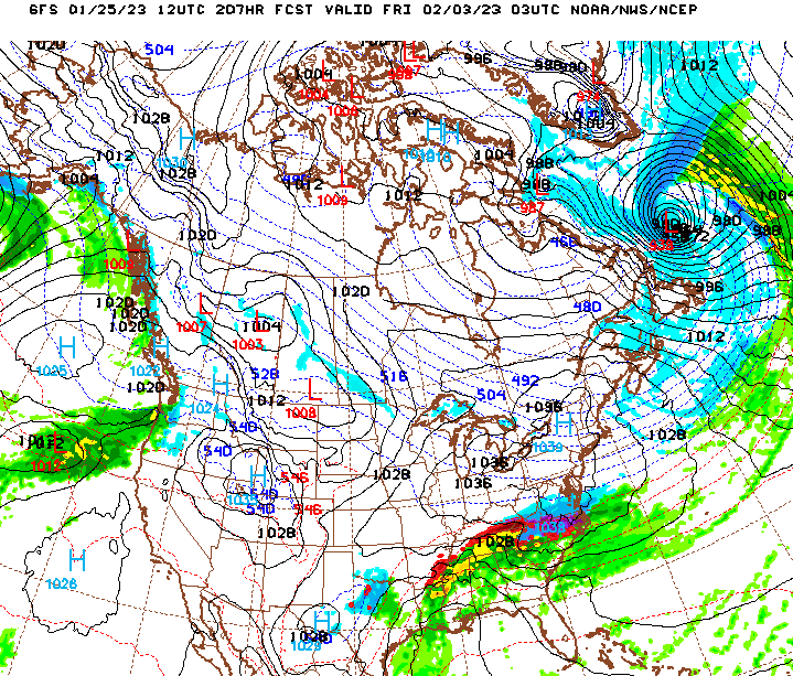
At least 2 events showing up on the GFS 12Z that could turn into opportunities with slight adjustments. Lots of energy flying around so anything could happen: 1/25-27 and 1/29-1/31.
-
2
-
-
1 hour ago, Grayman said:
Upstate , I’m a Gamecock fan so Im use to quitting. Lol. Fab February. Storms will make on cold air and track 500 miles south
Don’t know about that, you guys got the best of us. All joking aside, things can change quickly in winter and we’re only mid January. Hopefully February is our month in the SE.
-
2
-
-
8 minutes ago, Grayman said:
All weenies please report to your closest cliff. Let’s dive and get this over with.
NEVER!!!

-
1
-
7
-
-
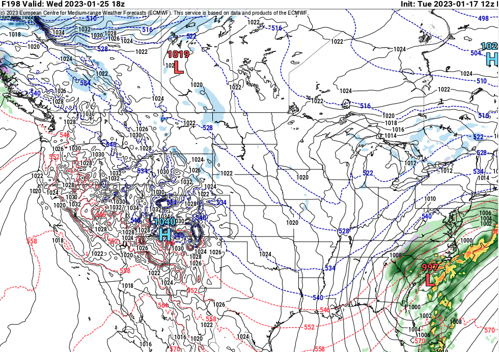
12z Euro

-
2
-
-
3 hours ago, WeatherHawk said:
I grew up in the NC Piedmont...and my dad used to tell me about those 3 Wednesdays...back to back. However, I'm afraid we've screwed up our climate, but hopefully it's not too late, if we can make some major changes soon. If not, I fear the crazy stuff happening out in CA is just a tip of iceberg heading our way.
Likewise, my parents and grandparents spoke often about that famous March. Grandfather said ice was on their back porch til the end of April. I've heard this period referred to as the "Holy Grail" of SE weather patterns with a persistent cross polar flow that lasted throughout March.
BTW...looking at overnight models. The western ridge is showing up consistently in the long range but a Nina like Ohio Valley storm track continues to dominate. Hopefully the ridge axis shifts a bit east. Would not take a lot for the SE to be in the game with cold air over eastern Canada.
-
2
-
-
Thanks for all the work. Hopefully see something on Ops soon. Still like to see the NAO be neutral or negative but can’t have it all. PNA is a more important teleconnection so I’ll take it.
-
1
-
-
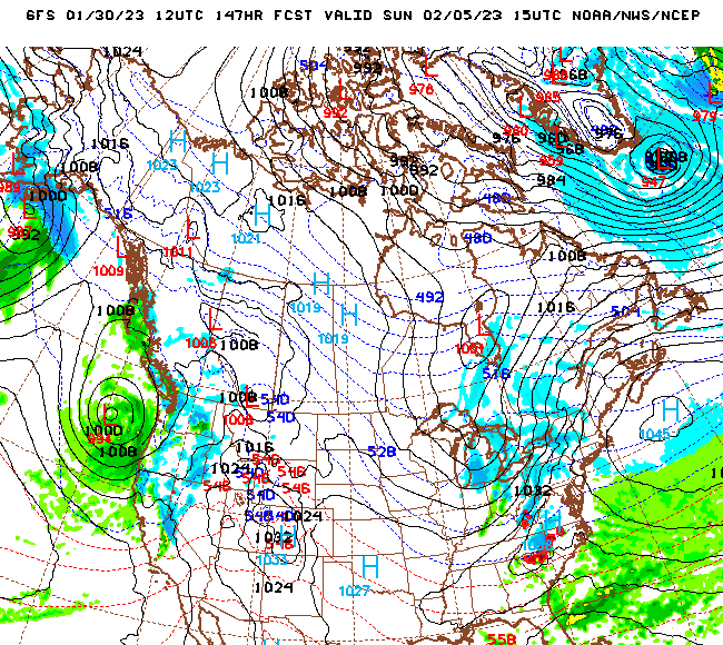
You can clearly see the ridge begin to build out west after the 21st. One thing is for sure. The reservoirs and snow pack in the west should have benefited from the ongoing pattern.
-
1
-
-
2 minutes ago, CAD_Wedge_NC said:
Maybe we can dodge most of the severe outbreaks.
I hope. Reminds me of 1983/84. Was a freshman in college. We had the brutal cold snap at Christmas with no snow. Mild January. A mild February with one little 2” snow event. Bad tornado outbreak end of March in South Carolina.
-
I can’t Pivotal load. Anyone care to give a short synopsis of next weekend and the long term? I’m lookIng for a generational ice storm soon. Was testing the generator this morning and she gave up the ghost.
-
1
-
-
13 minutes ago, GaWx said:
And in case anyone is wondering lol, the 12Z JMA (which also had a SE wintry threat at 12Z yesterday) joins the other models with a warmer solution and no widespread SE wintry threat.
Well GW looks like we're back to watching teleconnections. At least the AO and PNA look better today long-range and MJO still looks good.

-
18 minutes ago, GaWx said:
Preliminary 12Z Euro maps suggest to me that this run will be more similar to today's non-wintry 0Z than yesterday's wintry runs. Let's see what it ends up showing.
Yep, Euro transfers off the Delmarva.


Mid to Long Range Discussion ~ 2023
in Southeastern States
Posted
We’ve had a lot of cold dreary days this winter. Very few golfing days since November and when we did, the course was very wet