

hawkeye_wx
-
Posts
5,931 -
Joined
-
Last visited
Content Type
Profiles
Blogs
Forums
American Weather
Media Demo
Store
Gallery
Posts posted by hawkeye_wx
-
-
I'm pumped for tonight's 0.10" of rain with a few rumbles of thunder. Most models show most of the rain will be north and east of Cedar Rapids.
-
 1
1
-
-
Small, slow-moving lows sure like dumping on Chicagoland this summer.
-
 2
2
-
-
As most models suggested, we got nothing out of this front. The next week looks dry. It's amazing how difficult it is to get rain this year.
-
1
-
 1
1
-
-
On 9/13/2023 at 3:52 PM, hawkeye_wx said:
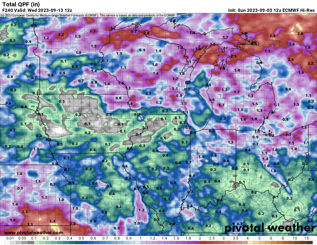
I'm really liking the model trend for late in the month. For weeks, the op GFS has been mostly bone dry across Iowa and surrounding areas, and it has been correct. Recent runs, however, have become much wetter across the region, beyond week one, with 2-3" in spots. The GEFS and EPS mean continue to gradually moisten up, region-wide, as well.
The GFS is still solid, but the Euro has reversed the positive trend and is going backward. The Euro is now trying to cut off a big low over the southeast US and also the Rockies/plains, with a blocking ridge forming over the lakes that does not allow much moisture to get into our region through day ten. It's giving me a flashback to our awful spring pattern.
-
2
-
-
I'm really liking the model trend for late in the month. For weeks, the op GFS has been mostly bone dry across Iowa and surrounding areas, and it has been correct. Recent runs, however, have become much wetter across the region, beyond week one, with 2-3" in spots. The GEFS and EPS mean continue to gradually moisten up, region-wide, as well.
-
10
-
-
Only 0.35" of rain overnight, at the low end of the model range. Now, it's back to bone dry for the next two weeks.
-
1
-
-
What the f'ing heck is going on with the models and tonight's wave? The Euro has flipped flopped several times now. Last night it went more bullish and north than ever, dropping 1.7" here. This morning it's right back south and only 0.30" here, now the driest of all models. The ensemble mean is flopping around, too. This is stupid.
-
1
-
-
20 hours ago, cyclone77 said:
Last night's Euro a lot more generous with a swath of rain from Iowa into northern IL Monday, with widespread 0.5-1.0 inch rains. Not enough to do much to help the overall drought situation, but would still be nice to see if it comes to fruition. Temps may have a hard time getting out of the 60s Monday as well under a heavy overcast/all day rainer.
Models are struggling with this wave. The Euro has generally been one of the more bullish models, but it has been all over the place. Yesterday's 12z run mostly took Cedar Rapids out of it, but the new 00z run is the most bullish, yet, with a swath of rain through Cedar Rapids of well over an inch. The GFS and other models have also become more bullish overnight. After this wave, models are very dry into late September, so we really need this.
-
The pressure is up to 940 mb this morning, and the wind is down some. Lee is no longer a cat 5. The NHC mentioned mentioned some possible sw shear.
-
The final recon dropsonde says ~925 mb.
-
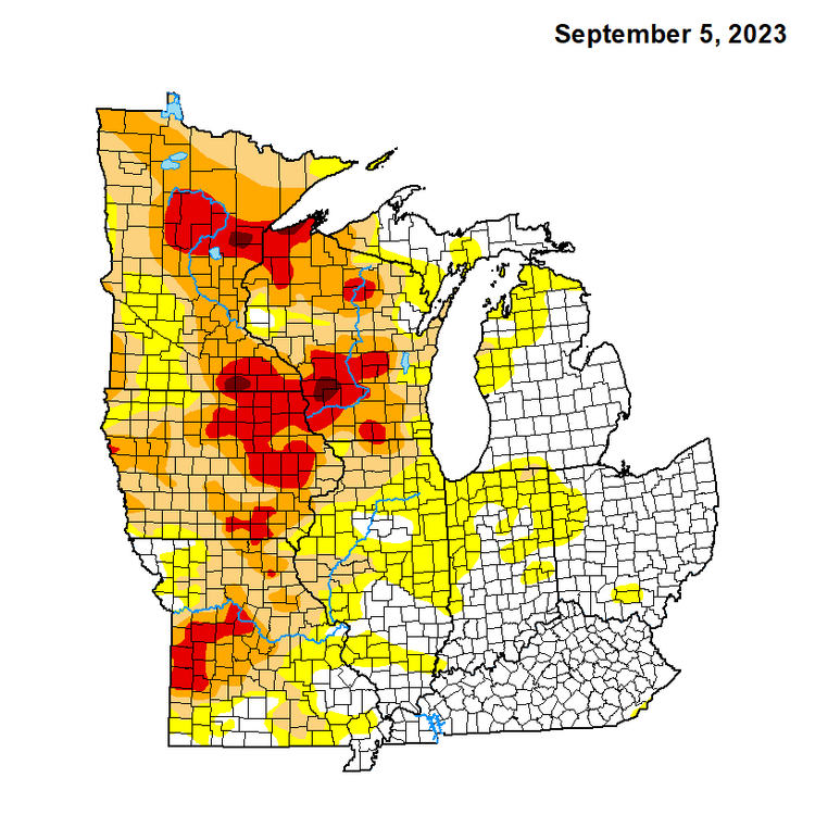
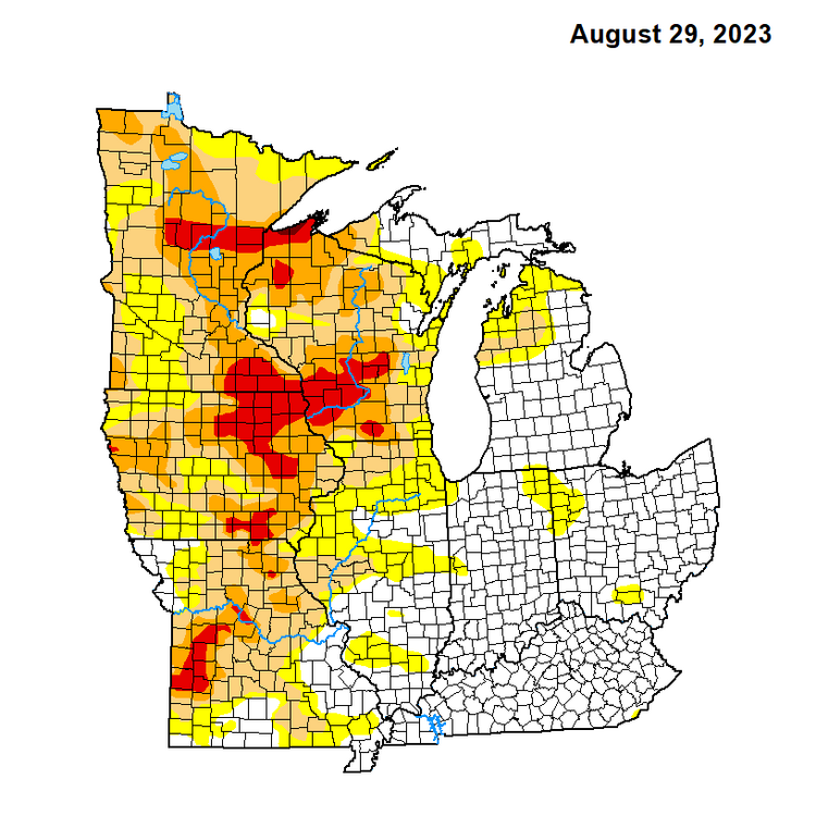
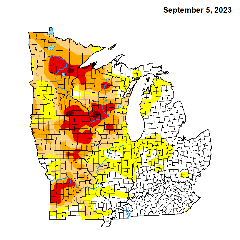
Extreme drought has expanded across east-central Iowa. A couple spots of exceptional drought have popped in se MN and sw WI.
-
1
-
-
928 mb per dropsonde.... darn low, but borderline cat 5 pressure. Typically, 920 mb is where you get into cat 5 territory.
-
2 minutes ago, WxWatcher007 said:
Another big time pass. Peak FL winds of 144 & 145kts, with a peak SFMR of 143, 152, and 157kts. Extremely tight core.
With a flight wind at 145 kts, it doesn't make sense the SFMR is 157 kts.
-
1
-
-
7 minutes ago, Floydbuster said:
That infrared loop looks extremely similar to Hurricane Rita in September 2005, when Rita explosively deepened in the Gulf of Mexico.
Sorry, but Rita, at 897 mb in the Gulf of Mexico, had the best appearance of any hurricane I've ever seen. It was perfect. The temp inside the eye was 31º, I think, and the dew point was 0º. I still have satellite photos and the vortex message saved on an old hard drive. At ~931 mb, Lee is not even close.
-
3
-
-
1 minute ago, WxWatcher007 said:
Data from the eyewall was backfilled. Peak FL wind of 148kts and SFMR of 141kts. Very tight core as expected.
The SFMR wind was even 139 kts (159 mph) in the sw quad.
-
3
-
-
There is still plenty of room for the satellite appearance to improve. Once the pressure gets down into the low 900s, the eye will become perfectly circular and the CDO will become uniformly thick with a distinct outer edge. Lee is nowhere near that, yet. Hurricane Jova, yesterday, had a very crisp, circular, core appearance.
-
3
-
 1
1
-
-
6 minutes ago, allgame830 said:
At what time will Recon be in the Hurricane?
Recon planes are almost always scheduled to arrive at the center of tropical cyclones within four time ranges.... 2330z-0000z, 0530z-0600z, 1130z-1200z, and 1730z-1800z. So, the new recon plane should be in the center of Lee in about one hour from now (2345z).
-
4
-
-
It's hot today, but there's a huge difference between 95 with a dew of 80 (last heat wave) and 95 with a dew of 58. A couple hours ago I was outside for a good ten minutes in the hot sun and I didn't even begin to sweat.
-
It feels like this is never going to end. This summer will get a big fat F grade from me (edit: maybe a D because there has been plenty of pleasant weather). We haven't had a month since April in which we received more than 50% of avg precip. If this latest Euro forecast pans out, we will have gone a month will <0.10" of rain.

-
2
-
-
My August rain total is 2.04".
My met summer rain total is 6.21".
-
A good part of eastern Iowa has been upgraded to extreme drought.
After decent recovery in early August, my lawn is now baked and crunchy.
-
1
-
-
1 minute ago, Nibor said:
Looks like recon is going to do one more pass?
They've only been in the air for a few hours and they are very close to home, so I would think they'll stay in the storm for several more passes.
-
3
-
-
Brand new dropsonde says 944 mb with 29 kt wind, so 941-942 mb.
I mentioned a little while ago that some dry air got wrapped into the outer core. One thing that did was eliminate the competition from outer core bands, so all the energy is going into the inner eyewall.
-
4
-
-
Radar shows a slug of dry air has been pulled into the east side of the core. That part of the core has dried out somewhat. Any outer core bands have been broken up and the eastern eyewall does not appear as thick or robust as the west side.
-
 1
1
-

September 2023 General Discussion
in Lakes/Ohio Valley
Posted
Nope. 0.16" in my gauge. The best rain split north and south of Cedar Rapids.
The entire spring and summer rain season has been an absolute dumpster fire. May-Sep 2023 is now drier than May-Sep 2012. We are now 12 inches of rain below avg during that period.
There is hope for some actual good rain this weekend, but I won't believe it until I see it in my gauge.