

hawkeye_wx
-
Posts
5,934 -
Joined
-
Last visited
Content Type
Profiles
Blogs
Forums
American Weather
Media Demo
Store
Gallery
Posts posted by hawkeye_wx
-
-
1 hour ago, A-L-E-K said:

did u screw hole?
Yeah, pretty much. My fear about the heavy cells on the southern edge of the MCS dropping too far south panned out. The northern end of two bands of heavy rain barely got me, but they only last a few minutes each. I ended with 0.66". The northern part of my county got only half of that. Well to the north, over northeast Iowa, the MCS's comma head dumped more heavy rain. Now I get to wait another two weeks for the next chance of five minutes of heavy rain.
-
 1
1
-
-
Cyclone has managed to get another inch of rain overnight before I've seen any.
I really hope all the heavy stuff moving in from the west doesn't suddenly crash south into the juicier air, leaving me with just a few hours of light rain. That's what I'm afraid of.
-
1 hour ago, cyclone77 said:
Yeah sure looks like we are go for a massive MCS moving through Iowa tomorrow morning.

Except the front has pushed southward, into far southern Iowa, this evening (dew point has dropped here), and now the models are adjusting the MCS south as well. The model hot spot is now west-central to south-central Iowa. Hopefully, we can get something.
-
 1
1
-
-
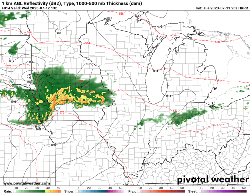
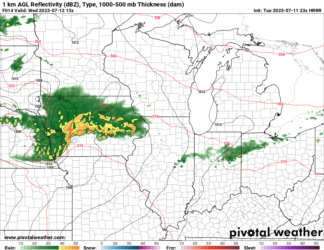
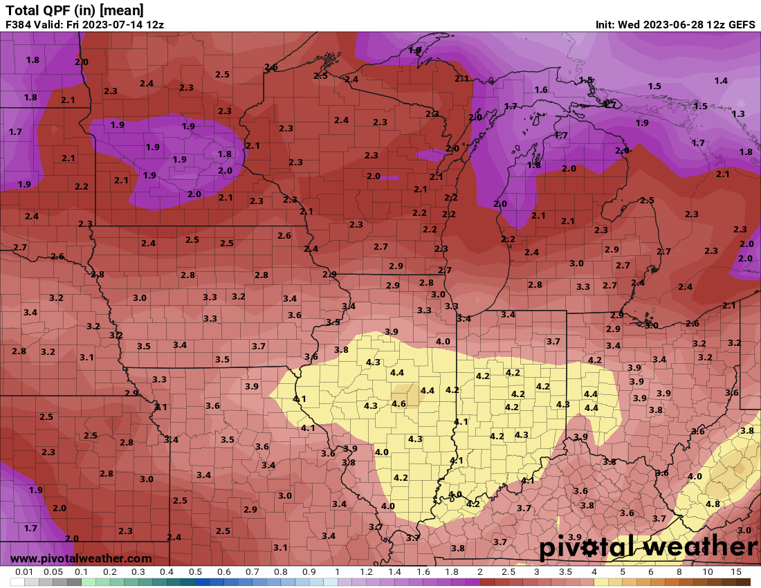
As we get closer to the action, the HRRR is looking increasingly good for much of my area. I hope this is fairly accurate.
-
 3
3
-
-
Only 0.33" here since June 25th. We badly need to get something decent Wednesday morning.
-
1
-
-
Models are still all over the place with tonight's MCS action. I could get an inch or nothing at all.
-
2
-
-
18 hours ago, hawkeye_wx said:
Models are strongly suggesting an MCS will form in NE/SD Tuesday and track east-southeast through Wednesday.
Models are now tracking the MCS farther south, potentially leaving my area dry again, because of course they are.
 ... and this might be it for another week or two.
-
4
-
-
Models are strongly suggesting an MCS will form in NE/SD Tuesday and track east-southeast through Wednesday.
-
Since June 25th, I've had five rain events.... 0.02, 0.17, 0.05, 0.04, 0.05". That little amount of rain doesn't even get the mulch wet under trees and plants.
-
1
-
-
After our inch of rain two weeks ago the lawn greened up somewhat. The green has vanished following two weeks without any real rain. The sprinkler goes back out Friday just to prevent a couple areas from getting worse.
-
3
-
-
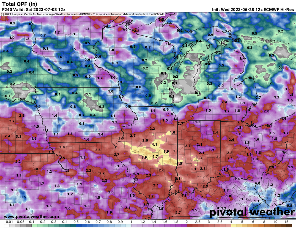
Unfortunately, this active pattern is playing out like the op Euro has been predicting. The storm train will continue to dump rain from the central plains to Missouri and Arkansas, but up here there will be little to nothing. We got the nice one inch of rain on June 24th, but instead of being the beginning of a change to a wetter pattern, it was just a one-time tease. Today's rain chance is pretty low and next weekend's event is gone. The next chance is a week away, yet again. It's nice there is no heat, but it has been a frustrating and boring spring/summer.
-
1
-
-
There is good model agreement that the midweek frontal passage will be timed very poorly for eastern Iowa. There is a good chance much of my area will get little or no rain from it.
-
1
-
-
Chicago low says, "You think you're done with me? Maybe I'll just back westward into the city again and keep dumping."
-
1
-
1
-
-
Mother Nature could not have timed the flooding rain worse for the NASCAR race today.
-
I only got enough rain to wet the pavement this weekend. The real rain was north yesterday and southeast today.
-
2
-
-
Now 80 mph wind is being reported from the line.
-
74 mph wind from the potent bow echo moving through Keokuk.
-
The region-wide drought may get a kick in the nuts over the next couple weeks... especially south of I-80. I just hope the storm complexes don't continuously reinforce the boundary south and prevent good rain from reaching areas farther north.

This is what I'm worried about... the op Euro scenario. A corridor from Nebraska to the Ohio Valley gets drought-denting rain, maybe even more, while pockets north of I-80 get little to nothing.
-
A decent complex of thundershowers moved through eastern Iowa overnight and dropped about 0.20" in my gauge. Models didn't show much. I'm expecting much of the action over the next week to pass south of me.
-
The thick smoke has moved out of my area. It's still hazy, but the sun is brighter and the smell is much less. The west shore of Lake Michigan looks to be stuck in this crap for quite a while.
-
This is, by far, the thickest smoke we've had in eastern Iowa this year. Satellite shows it may begin to thin out over the next couple hours.
-
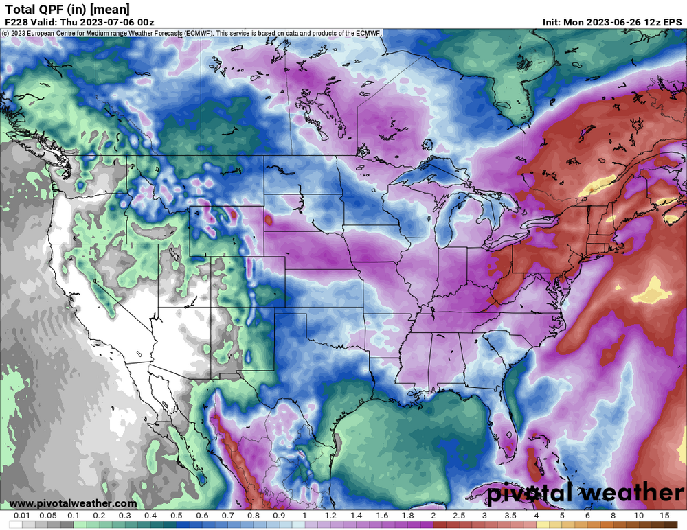
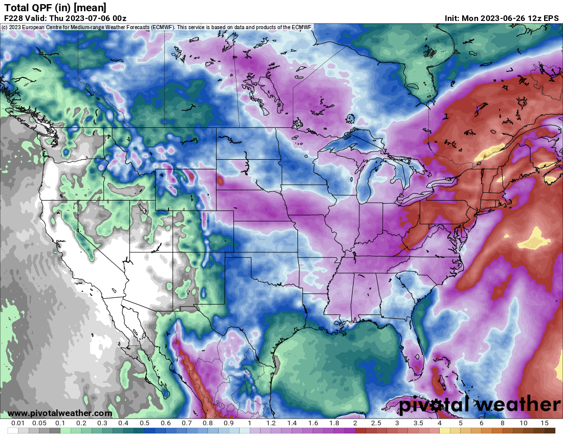
EPS is showing where the ring of fire may set up. Southern Minnesota, northern Iowa, and southern Wisconsin may end up pretty dry. The op Euro shows little to no rain over much of that area over the next ten days. I'm sure glad we got some solid rain Saturday.
-
1
-
-
The wind has really been whipping today. I had to put some potted flowers in the garage so they wouldn't break. We haven't had a windy day like this in several weeks.
-
1
-
-
For a while it looked like I might get goose-egged. At the last minute, the gap in the line of storms moving across eastern Iowa filled in and soaked the Cedar Rapids area. There were a couple scattered warnings in the area, but I only received beautiful, straight-down rain. Most personal gauges across the metro area are reporting over an inch. I got 0.96".

It is no coincidence our dewpoint shot up to 70º late this evening. It feels and smells good to finally have humid, wet air in June.
-
3
-


July 2023 General Discussion
in Lakes/Ohio Valley
Posted
I'm sitting at only 0.75" in July.