

hawkeye_wx
-
Posts
6,320 -
Joined
-
Last visited
Content Type
Profiles
Blogs
Forums
American Weather
Media Demo
Store
Gallery
Posts posted by hawkeye_wx
-
-
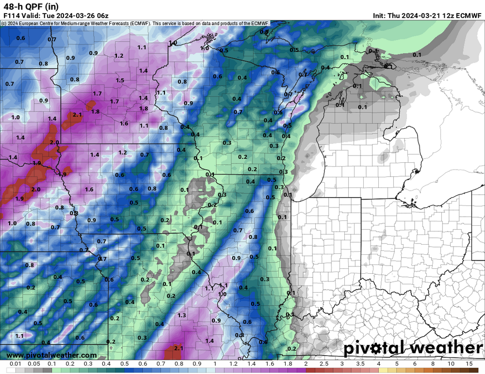
Three days ago the Euro was consistently showing 2-3" of rain across eastern Iowa from the upcoming big storm. This is what it has devolved into.
-
 2
2
-
-
I'm really liking the medium to long range. Ensembles are spitting out widespread 2-3" of precip across the region through 15 days as big troughs eject out of the west and the gulf is wide open.
-
 3
3
-
-
Another long-duration light rain event produced 0.45" here. March is up to 1.00".
-
3
-
-
We got a much-needed 0.53".
-
1
-
-
This was a big ol' dud here. I got 0.02". The late-week system had better pan out.
-
2
-
-
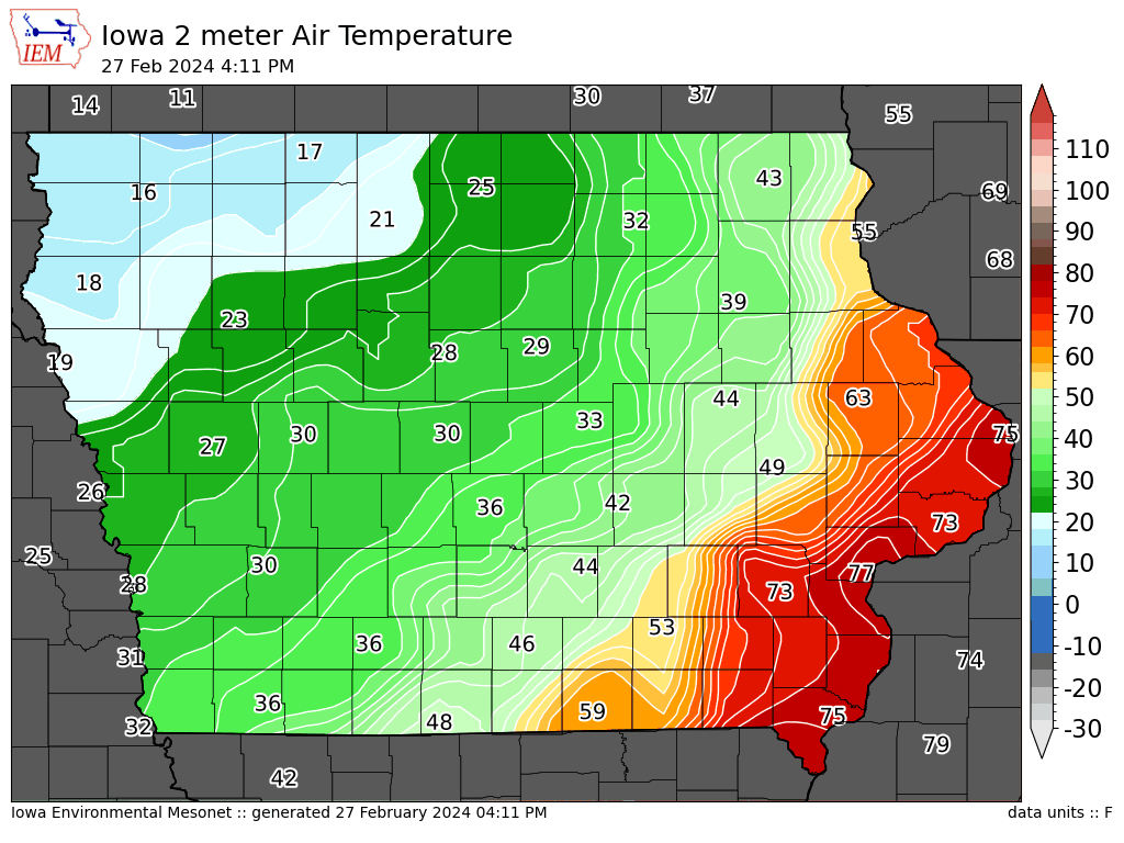
Cedar Rapids officially hit 80º this afternoon.
-
The temp is up to 78º here, with low 80s across southeast Iowa. While still low, the 47º dewpoint is 15º higher than it was last week when we reached the 70s, so it feels more springy.
We REALLY need to start getting some rain. It is very dry here.
-
We REALLY need March to be wet. There has been jack squat for precip since the big mid January snow and melt.
-
2
-
-
We have a wind chill of -17º this morning.
-
2
-
-
-
1 hour ago, cyclone77 said:
Tomorrow could be a day in which we see mid-upper 70s in the afternoon, and snow on the same calendar day if it arrives before midnight like some of the guidance shows.
The HRRR has 74º here at 2pm, snow showers by midnight, and a -15º wind chill by sunrise Wednesday.
-
We are smashing records in Iowa. Cedar Rapids is up to 75º.
The February record is 76º, set back in 2017.
-
1
-
 1
1
-
-
The Euro has suddenly become much more progressive. It now has the pacnw trough completely bypassing the low off the SoCal coast, so, instead of digging and slowing, it races the trough eastward across the country.
-
I can't imagine we've had many February afternoons in the low 60s with a northwest wind.
-
2
-
-
I was looking forward to getting some good rain with storms next week, but the models have trended toward pushing everything to the east too quickly. The Ohio Valley and eastern Lakes get storms, but farther nw we get nothing.
-
1
-
-
We are over-performing by several degrees today, now at 56º. It's going to be a very mild week.
-
1
-
-
The op GFS is really blowtorching the end of the month. It has been showing this for several runs. Frankly, I hope the heat gets dialed back quite a bit as we get closer. It's way too early for that.
-
I got 0.18" of rain, the first precip in three weeks. My area is still in extreme drought, so we'll take whatever we can get.
-
Euro - Kuchera

-
1
-
 1
1
-
-
It is 65º here and I just heard a rumble of thunder.


-
2
-
-
The signal is there for a possible storm early next week, but models are all over the place from run to run. The op Euro just shifted from the deep south back to the upper midwest in one run.
-
5 hours ago, cyclone77 said:
Good shot at mid 60s here on Thursday. Just some scattered piles/drifts left at the moment, but even those will be gone by Tue or Wed. With the ground continuing to dry out the sky's the limit with temp potential.
Clouds and/or showers will be the one thing that could hold us down a bit on Thursday.
-
It's out there pretty far, but the latest op Euro, GFS, and GDPS (Canadian) all show a nearly identical Colorado low producing good snow across IA/WI/IL late next weekend.
-
For the second consecutive day, a stratus deck advecting in from the east killed our temp, holding us in the mid 30s. The east wind off the lakes can be a real downer in winter and spring.

March 2024 General Discussion
in Lakes/Ohio Valley
Posted
We've been upgrade to a warning (3-8"). I'm at about 2.3" so far, but it won't last long enough to get too much more.