

hawkeye_wx
-
Posts
5,943 -
Joined
-
Last visited
Content Type
Profiles
Blogs
Forums
American Weather
Media Demo
Store
Gallery
Posts posted by hawkeye_wx
-
-
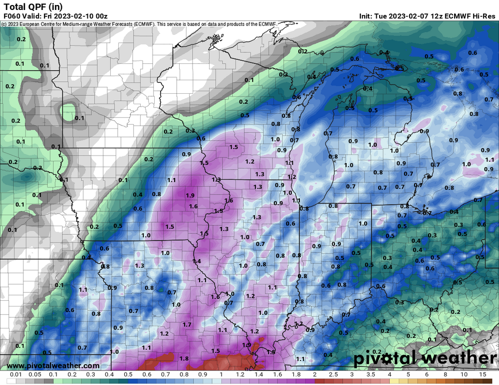
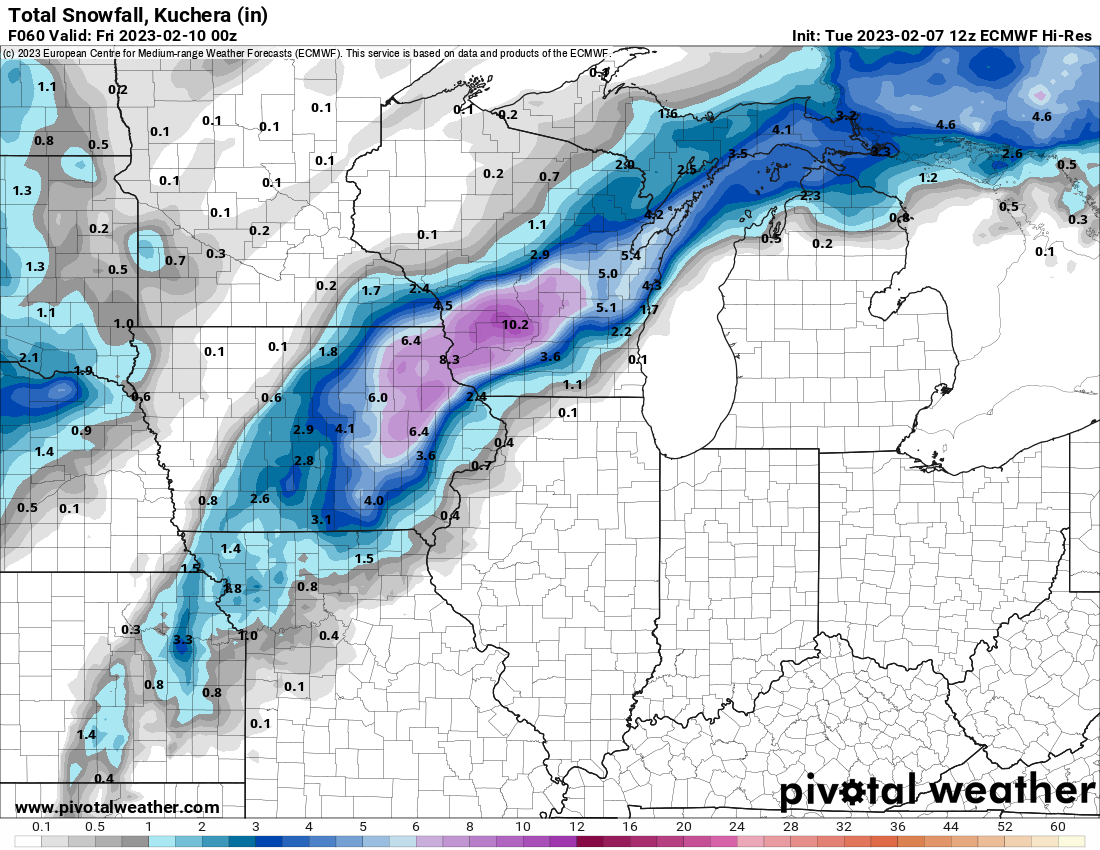
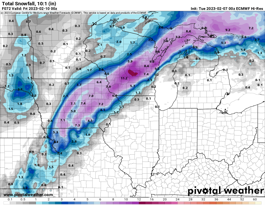
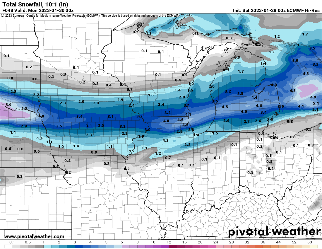
This morning's trend has been positive for eastern Iowa. The models that were fading southeast have backed up nw a bit and solidified the defo zone precip.
-
The Euro has been the most bullish model with both total precip and snow in Iowa. Tonight's run pulled the rug out, cutting everything by at least half. I'm really getting tired of being teased by models this winter.
-
 1
1
-
 1
1
-
-
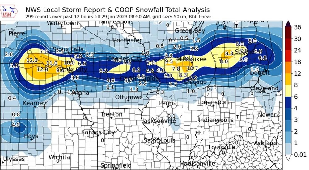
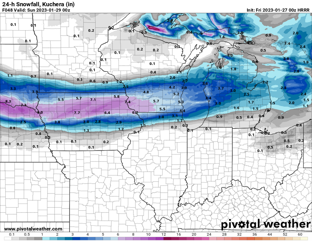
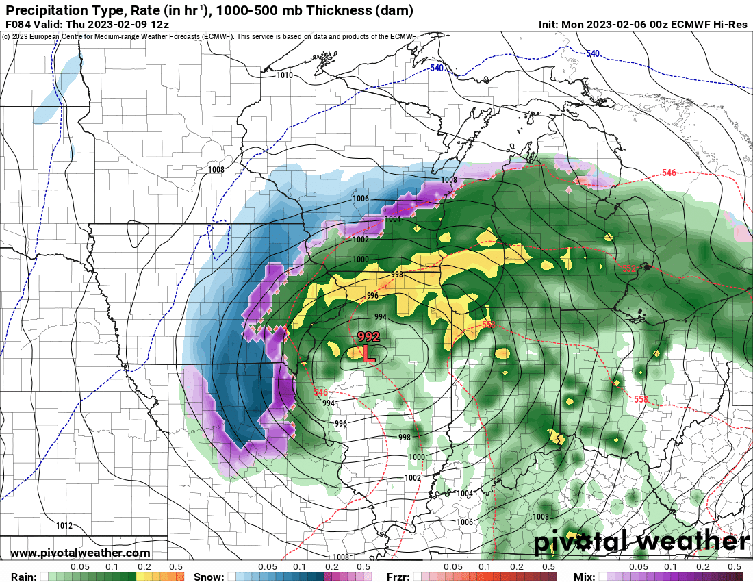
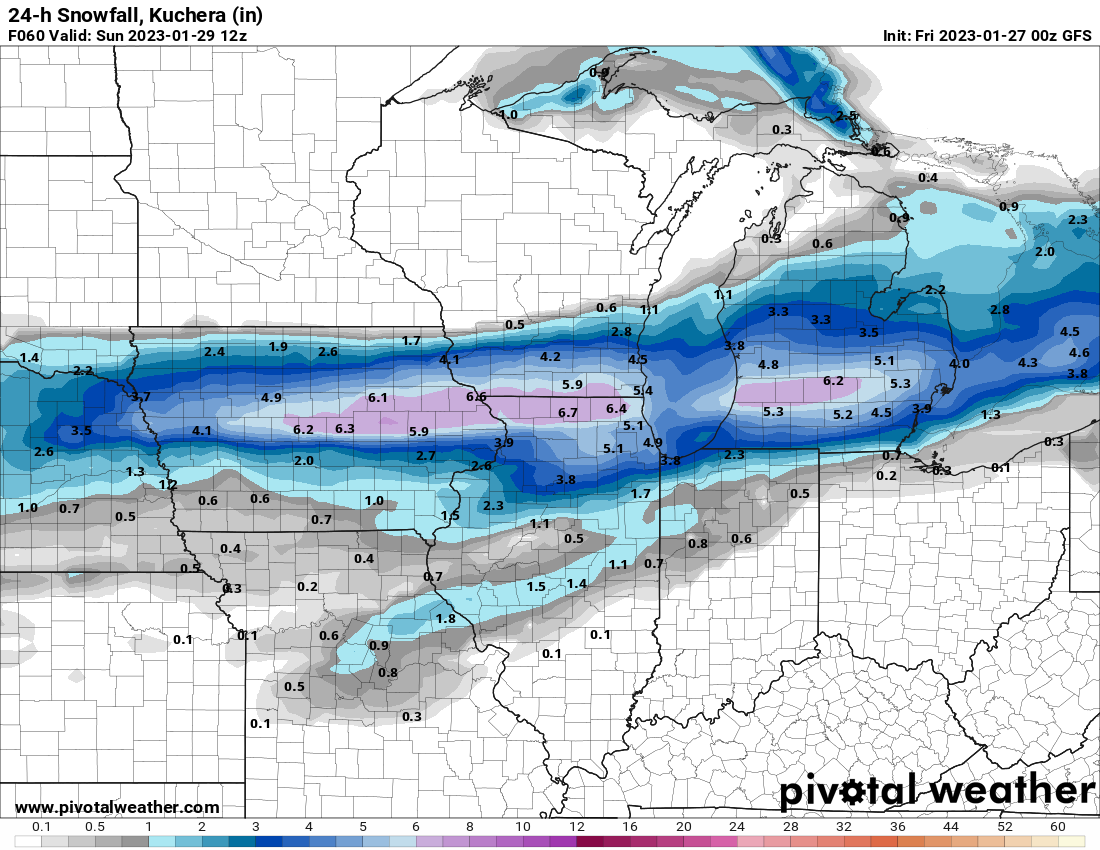
Man, another system, more model frustration. Tonight, half the models show little, if any, precip in much of the Iowa winter storm watch that was just issued this afternoon. The GFS still hits my area hard, but other models are east and weak with the backside precip. I don't know what the NWS is going to do with the forecast.
-
1 minute ago, madwx said:
0Z models say wagons SE so far
Definitely. The 18z Euro was a bit southeast, then the NAMs shifted way east. The HRRR has always been on the east edge and hasn't budged. The western part of the watch area in Iowa is being deserted by the models.
-
DMX and DVN have issued a winter storm watch for central to northeast Iowa.
-
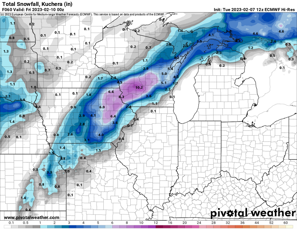
12z Euro is super juiced, with a very heavy burst of snow Thursday morning. Other models show considerably less precip and snow. I'm still thinking 3" of snow in my yard, at most. This stuff will be concrete. DVN is thinking a 4-6:1 ratio.
-
2
-
-
I saw a bit of lightning to the southwest this evening as a line of weak cells approached Cedar Rapids, but the lightning fizzled and I got a ten-second shower.
-
The 00z Euro did become stronger and snowier compared to the 12z run. Of course, this will be very wet, low-ratio snow, and if the Euro is too cold by a degree this forecast will bust. This is the snowiest of all the models this evening. I would err on the low side. DVN, this afternoon, said not much snow south of Waterloo-Dubuque. That's certainly possible.
I can't help but get a bit angry because we finally get a rare, strengthening low, loaded with moisture, tracking from St. Louis to Chicago (maybe once every few years track) and there is no f'ing cold air.... in early February. 19 times out of 20 this is a big snowstorm.

-
 2
2
-
-
We are expecting 47º with 40 mph wind gusts this afternoon. It should nuke the remaining couple inches of snow cover.
-
This would typically be a nice snowstorm this time of year. I might get to shovel some slush at the end.

-
Snowpack makes a big difference. This morning northern Iowa was 15-25 below. Southern Iowa was near 0. Cedar Rapids hit -9 with a few inches on the ground.
-
1
-
-
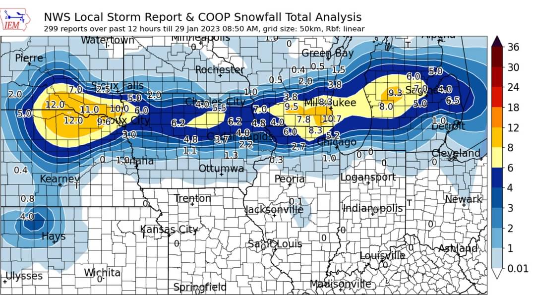
I'd give this winter a D. We are not terribly below avg snow, but it has been a nickel & dimer winter, and most of the snow has been at night. There has been no real big snow chance. It's just a very blah winter outside of the pre-Xmas blizzard (only a few inches).
-
1
-
-
8 hours ago, ChiTownSnow said:
IMO, Bang up job by NWS Milwaukee/LOT on this one.
Very tricky forecast and when you look at the published snow maps, forecast verified pretty darn close. Milwaukee burbs got to their 10 and NW LOT got to 6
Very sharp cut off as advertised for South of 88. Only caveat may be extreme E/NE LOT underperforming
This was the Euro the night before the event... not good.

-
A pretty heavy-looking band has been parked over Madison for a while.
-
With the evening band of snow failing to materialize, after being forecasted by every model, my storm total is likely to be only 2.0". This was a pretty big stinker. The south models (I'm looking at you Canadian and Euro) were awful.
-
Kind of a stinker over here. The main band only dropped 1.9" in my yard. The tail might drop another half inch later. I finally got into a band with a solid rate this morning, but it lasted about ten minutes. The south models (Canadian, Euro) were wrong for Iowa.
-
This band of snow pushing through Cedar Rapids this morning is not even moderate. The flakes are fairly small and the rate is meh. I just measured 0.8" and radar shows the back edge approaching quickly.
-
00z Euro

-
 1
1
-
-
00z GDPS (Canadian) is still on the south edge of the model range, agreeing with the 18z Euro.
-
All the short-term models (hrrr/nam/fv3) are still well north of the 18z Euro.
-
The 00z GFS nudged north as well. The south edge in Iowa may be razor sharp. The Chicago area at least gets a late influx of moisture as the wave reaches them, which spreads the love a bit.

-
The HRRR is still drifting north.
-
1
-
-
6 minutes ago, sbnwx85 said:
Two days ago it looked like there could be a decent system in the Great Lakes in the middle of next week. Now both GFS and Euro have a big Canadian high traversing the area.
The northern stream dominates. The good energy gets stuck in the sw US and then strung out across the south.
-
1
-
-
The main storm and secondary energy both disappointed here. I finished with a grand total of one inch.


February 8-9 Should There Be a Thread For This Storm
in Lakes/Ohio Valley
Posted
All southeast models came back nw, at least a bit, this morning. The totals should probably be cut back even more than Kuchera because the ground will be warmish and very wet/soggy when it begins to snow. The bottom inch of snow will turn to slush.
12z Euro