

hawkeye_wx
-
Posts
5,931 -
Joined
-
Last visited
Content Type
Profiles
Blogs
Forums
American Weather
Media Demo
Store
Gallery
Posts posted by hawkeye_wx
-
-
Next week's big storm is still flopping around a bit. The GFS was south of Iowa a couple days ago, but now it has jumped way north and dumps most of its rain over SD/MN. The UK is still south. The Canadian and Euro are in between, hitting Iowa hard.
-
 1
1
-
-
It is still several days away, but models are trending better (both op and ensembles) mid to late next week regarding a potential heavy rain system. The current trend is the big southeast Canada/great lakes upper low backs off a bit and allows the western energy to eject farther north. We really need this to happen.
-
3
-
-
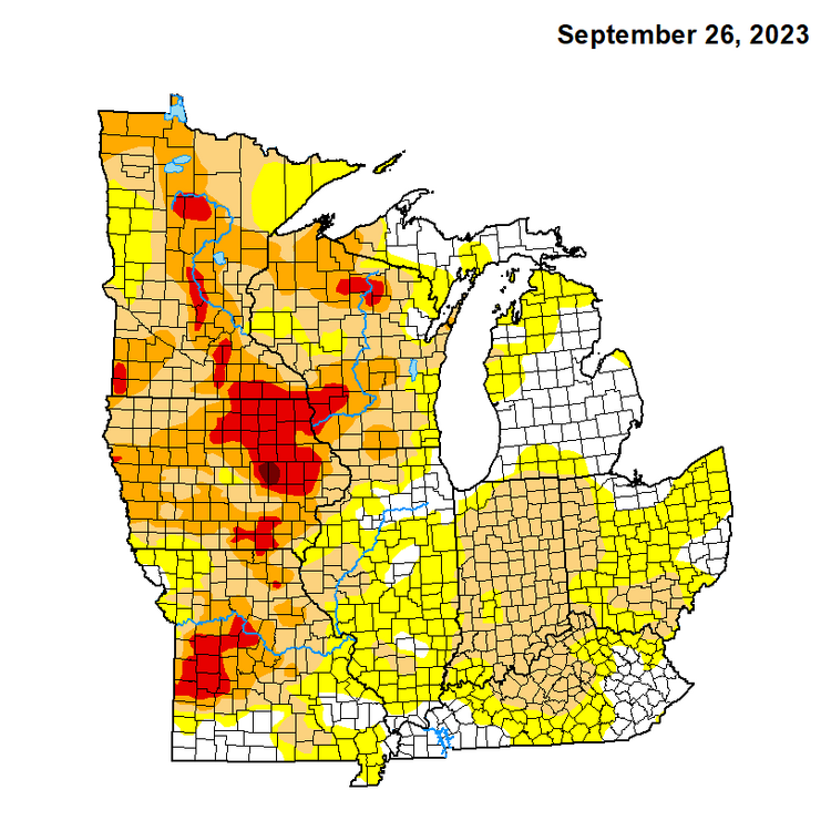
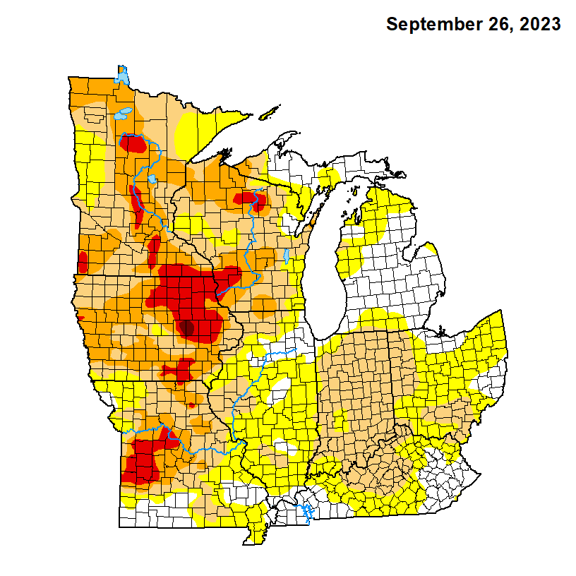
We made it! The exceptional drought has expanded over Cedar Rapids. This is officially the worst drought this century. 2012 was worse over a much bigger area, but it has never been this bad in the Cedar Rapids area, specifically.

-
 1
1
-
-
7 hours ago, cyclone77 said:
Might not get out of the 50s Fri and Sat, with frost next week.
The 00z Euro really digs in the southeast Canada/great lakes upper trough this weekend through next week. The entire 10-day period never gets out of the 50s to low 60s around here. Summer is over.
-
As expected, zero rain here overnight as the line vanished. The next chance that won't pan out is about nine days away.
The wet season is waning, but October still averages 3" here. However, at this point it just feels impossible, like we are living in a desert in between mountain ranges.
-
Wet patterns no longer exist for this area.
-
2
-
-
Cedar Rapids also hit 91º this afternoon.
-
Cedar Rapids has set a new record, hitting 93º at 3pm.
Update: Cedar Rapids topped out at 94º.
-
2023

-
2
-
-
JFK airport in NYC got more rain this morning than Cedar Rapids has received since mid May.
-
2
-
-
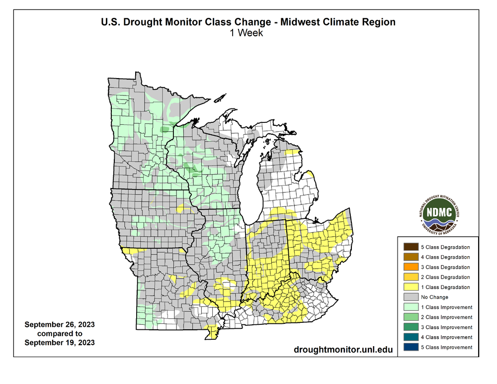
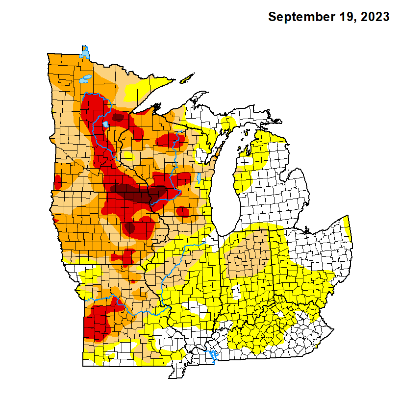
As expected, there is improvement in the drought across the midwest where the good rain fell over the weekend. Chicagoland is almost entire out of it. The swath of exceptional drought in the MN/IA/WI tri-state area is gone. The only exceptional drought remaining in the midwest region is near Cedar Rapids. It's possible it could expand over CR in the next week or two as we get a bunch of 80s with no rain.
-
2
-
-
After getting nothing over the weekend, we got nothing again today as the upper low moved over us. It appears I will finish September with only 1.08" of rain, the driest month of 2023.
-
2
-
-
It appears Madison, and much of southern Wisconsin, got a nice soaker overnight.
-
2
-
-
Epic bust.
For two weeks models locked in on this weekend for potential widespread, good rain. Only a few days ago the Euro had 2-3+ inches falling across all of Iowa and surrounding areas. The GFS was similar. Even as they backed off, they still showed scattered showers and storms moving into eastern Iowa Saturday night. Instead, there wasn't even anything in central Iowa and now a backdoor front has swept dry air into eastern Iowa, effectively ending any rain chance.
Cedar Rapids has officially received 0.00" from this system. I got 0.23" Friday.
The only hope remaining is the upper low as it drifts southeast across the region Monday night into Tuesday. Most models have been keeping most of the rain northeast of here, from se MN to northern IL. A few models are tracking the upper low a bit farther sw and tease some decent rain here, so there is still a chance to salvage something out of this.
-
3
-
-
Models were split/back-and-forth regarding whether or not the tail of the Iowa disturbance would build south enough to hit Cedar Rapids. It did not. A couple slow-moving, strong cells are dumping heavy rain nw of CR, but late Saturday into Sunday will have to come through for us.
-
A strong cell passing just nw of Cedar Rapids has been tornado-warned for a while. The sirens have gone off here a couple times, even though CR is not in the path.
-
2
-
-
I picked up a very quick quarter inch midday as a thin line lifted north through the area. It was the heaviest downpour I've seen in months. Cyclone, from the same line, got over an inch, so he's really doing well this month.
-
1
-
-
Exceptional drought, the highest level, is now expanding.
Quad Cities NWS says this is the first time there has ever been exceptional drought in east-central Iowa (since 1999).

-
 1
1
-
-
7 minutes ago, cyclone77 said:
Stayed in the 60s today with an all-day heavy overcast, with steady mist/very light rain. Added up to 0.07".
Similar here... was supposed to be sunny and low 80s, but the low backed into southeast Iowa and pulled a bunch of clouds and cool air into my area. We jumped to 76 early, but fell back.
-
The drying trend from the east on the models continues. The great lakes ridge is becoming stronger every run.
-
1
-
-
The model trend for this weekend into early next week is bad. There is now unanimous agreement that blocking will win and this system will hit a brick wall over Iowa/Minnesota. Those juiced-up Euro runs are long gone. The GEFS and EPS qpf mean have really dried out from Cedar Rapids to Minneapolis, with nothing east of there. 2023 just keeps on giving.
-
1
-
1
-
-
We added 0.26" last night, making yesterday's event somewhat decent (0.42").
-
9 hours ago, A-L-E-K said:
euro brings u the goods
Meanwhile, the GFS has removed all rain this weekend into early next week because of a blocking ridge, and most recent Canadian runs have shown the blocking as well. It's too volatile to count on anything at this point.
-
1 hour ago, A-L-E-K said:
euro brings u the goods
It's a complicated, blocky pattern and models are showing wild fluctuations from run to run, but, overall, it's looking up for Iowa at least. The new op Euro stalls the upper low over our western subforum area and would be ideal... inches of rain over several days. The EPS qpf mean, however, only has 1.25-1.50" through the period, though, which means there are also plenty of drier ensemble members, so a lot can change.


October 2023 General Discussion
in Lakes/Ohio Valley
Posted
Models are flopping around, but the general trend is way north with the strong mid to late week system. The Euro just jumped an entire state north, shifting the heavy rain from Iowa to SD/MN. The heavy defo band now goes through Duluth.