mahantango#1
-
Posts
5,429 -
Joined
-
Last visited
Content Type
Profiles
Blogs
Forums
American Weather
Media Demo
Store
Gallery
Everything posted by mahantango#1
-

Central Pa. Spring 2024
mahantango#1 replied to mahantango#1's topic in Upstate New York/Pennsylvania
Kudos to abc27 for recognizing the amount of rain that fell in Upper Dauphin County last night on their weather segment @7pm. -
Central Pa. Spring 2024
mahantango#1 replied to mahantango#1's topic in Upstate New York/Pennsylvania
Hopefully with Voyagers return he'll bring the heat so we can dry out. -
Central Pa. Spring 2024
mahantango#1 replied to mahantango#1's topic in Upstate New York/Pennsylvania
We need a much needed break from this pattern. Maybe DT's crystal ball will offer us some hope in the future. -
Central Pa. Spring 2024
mahantango#1 replied to mahantango#1's topic in Upstate New York/Pennsylvania
I guess this sums up most of this coming weekend. -
Central Pa. Spring 2024
mahantango#1 replied to mahantango#1's topic in Upstate New York/Pennsylvania
1.30in or rain overnight. 1.53 for the week. 4.50 for the month, and 20.93 for the year. An early moisture laden tropical storm headed from Gulf would spell doom for Pa. if it happens in the next several weeks. We need to dry out. -
Central Pa. Spring 2024
mahantango#1 replied to mahantango#1's topic in Upstate New York/Pennsylvania
I just looked at the rain gage reading an im up to .70 for the day and most of that is from this evening. -
Central Pa. Spring 2024
mahantango#1 replied to mahantango#1's topic in Upstate New York/Pennsylvania
That might be a good idea. -
Central Pa. Spring 2024
mahantango#1 replied to mahantango#1's topic in Upstate New York/Pennsylvania
I hope it soon stops redeveloping and moves on. -
Central Pa. Spring 2024
mahantango#1 replied to mahantango#1's topic in Upstate New York/Pennsylvania
It was pouring awhile ago. .30 so far today. Tired of this weather pattern, sun one day rain the next 3 days or so it seems. -
Central Pa. Spring 2024
mahantango#1 replied to mahantango#1's topic in Upstate New York/Pennsylvania
He has been wrong. -
Central Pa. Spring 2024
mahantango#1 replied to mahantango#1's topic in Upstate New York/Pennsylvania
-
Central Pa. Spring 2024
mahantango#1 replied to mahantango#1's topic in Upstate New York/Pennsylvania
So now we know where you get your forecasts -
Central Pa. Spring 2024
mahantango#1 replied to mahantango#1's topic in Upstate New York/Pennsylvania
Dt is available, he'll even draw you a rain map. -
Central Pa. Spring 2024
mahantango#1 replied to mahantango#1's topic in Upstate New York/Pennsylvania
-
Central Pa. Spring 2024
mahantango#1 replied to mahantango#1's topic in Upstate New York/Pennsylvania
Wondering that too. -
Central Pa. Spring 2024
mahantango#1 replied to mahantango#1's topic in Upstate New York/Pennsylvania
I knew you'd cave, to get those special forecasts. -
Central Pa. Spring 2024
mahantango#1 replied to mahantango#1's topic in Upstate New York/Pennsylvania
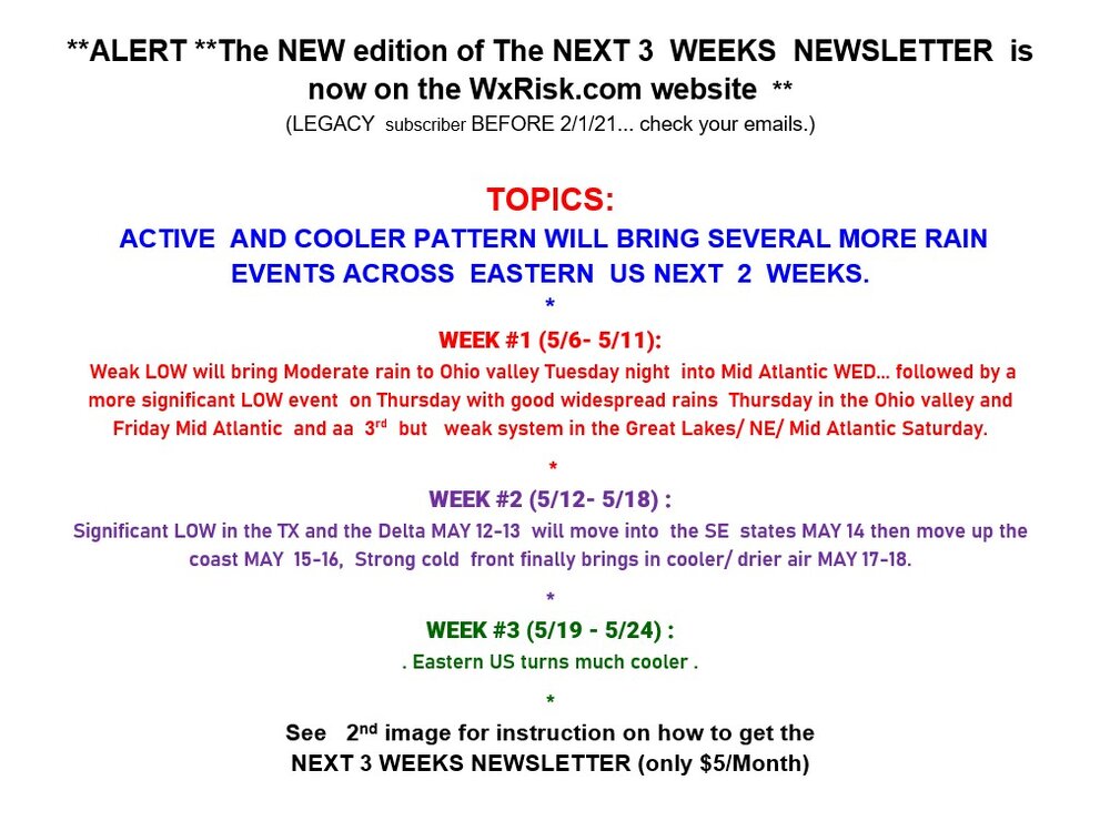
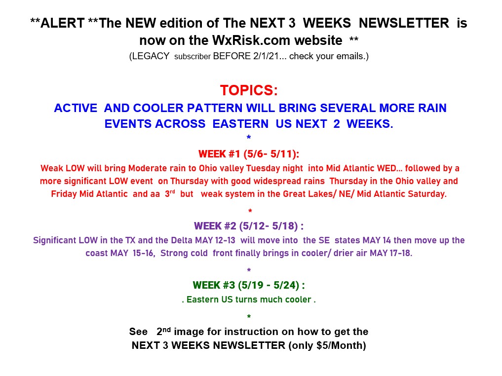
Wxrisk.com · ** BACK BY POPULAR DEMAND-- THE SPECIAL EVENT FORECAST SERVICE *** As we move into the warm season months. many of you in the Middle Atlantic, the Ohio Valley, the Tennessee Valley, the Southeastern states, and New England will have important outdoor events coming up. Weddings… pool parties ...family gatherings ...group hikes… vacations to the beach.... or the mountains... or into the big cities for sightseeing… or what have you. Wouldn't it be great to know whether or not you big plans / could be impacted by Weather problems? When you sign up for the *** EVENT FORECAST SERVICE *** it is like getting your own meteorologist looking out for you and your plans. For the price of just a Starbucks gift card or Panera gift card you tell me the date of your activities or plans ...the timing... any special concerns you have ...and the size of the event. All you have to do is contact me through the Facebook page and we Are good to go. You can get it one or two week coverage which means that you start getting the forecast information for me one week out or two weeks out depending on what you sign up for. The only other restriction is that this is just for one event. So if you have other ongoing concerns you might be better served by purchasing the Mid-Atlantic Operational forecast product which you can get through the WxRisk website for only $35 a month which covers VA NC WV MD DEL. Sounds good? Any questions just ask me. I hope I can help you out with your plans this summer. -
Central Pa. Spring 2024
mahantango#1 replied to mahantango#1's topic in Upstate New York/Pennsylvania
Finished up with 1.70 rain from the past event. -
Central Pa. Spring 2024
mahantango#1 replied to mahantango#1's topic in Upstate New York/Pennsylvania
Will there be thunderstorms with this? -
Central Pa. Spring 2024
mahantango#1 replied to mahantango#1's topic in Upstate New York/Pennsylvania
2.25 for the week here. -
Central Pa. Spring 2024
mahantango#1 replied to mahantango#1's topic in Upstate New York/Pennsylvania
1.37 rain so far for the event. Wasn't expecting this much. NWS had me getting .50-.75 -
Central Pa. Spring 2024
mahantango#1 replied to mahantango#1's topic in Upstate New York/Pennsylvania
If it wants to rain, let it. I completed mowing. -
Central Pa. Spring 2024
mahantango#1 replied to mahantango#1's topic in Upstate New York/Pennsylvania
Hopefully the rain holds off for quite awhile, so I can mow. -
Central Pa. Spring 2024
mahantango#1 replied to mahantango#1's topic in Upstate New York/Pennsylvania
Rain this morning .37 monthly total now .98 -
Central Pa. Spring 2024
mahantango#1 replied to mahantango#1's topic in Upstate New York/Pennsylvania