

Met1985
-
Posts
14,020 -
Joined
-
Last visited
Content Type
Profiles
Blogs
Forums
American Weather
Media Demo
Store
Gallery
Posts posted by Met1985
-
-
Rabun-Habersham-Swain-Graham-Northern Jackson-Macon-Southern
Jackson-Transylvania-Henderson-Oconee Mountains-Pickens Mountains-
Greenville Mountains-
Including the cities of Stecoah, Cedar Mountain, Clayton, Alarka,
Cullowhee, East Flat Rock, Pine Mountain, Cashiers, Wolf
Mountain, Baldwin, Tuxedo, Almond, Little River, Bryson City,
Hollywood, Fletcher, Rocky Bottom, Rainbow Springs, Demorest,
Luada, Kyle, Brevard, Robbinsville, Mountain Rest, Dana, Sylva,
Franklin, Etowah, Mountain City, Tuckasegee, Glassy Mountain,
Wesser, Clarkesville, Highlands, Cornelia, and Hendersonville
238 PM EST Fri Jan 26 2024
...FLOOD WATCH IN EFFECT FROM SATURDAY MORNING THROUGH LATE SATURDAY
NIGHT...
* WHAT...Flash flooding caused by excessive rainfall is possible.
* WHERE...Portions of northeast Georgia, including the following
areas, Habersham and Rabun, western North Carolina, including the
following areas, Graham, Henderson, Macon, Jackson, Swain and
Transylvania, and upstate South Carolina, including the following
areas, Greenville Mountains, Oconee Mountains and Pickens
Mountains.
* WHEN...From Saturday morning through late Saturday night.
-
4 minutes ago, Carvers Gap said:
Euro Weeklies are bumping up snow for Feb and early March. I don't worry about actual totals, but just look for storm tracks.
You mind if I share this in my forum?
-
 3
3
-
-
23 minutes ago, Carvers Gap said:
That is exactly what the my post was about....they are all in sync including the EPS/GEFS/GEPS. They are all singing the same song. They are within just a few hours of each other re: progression.
Yes sir. Things are progressing nicely in my opinion. Great posts Carver.
-
1
-
-
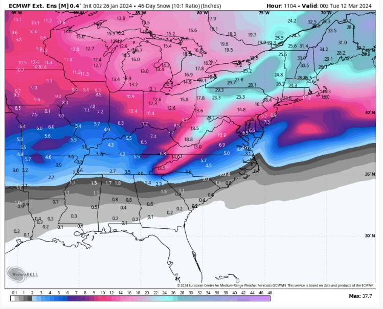
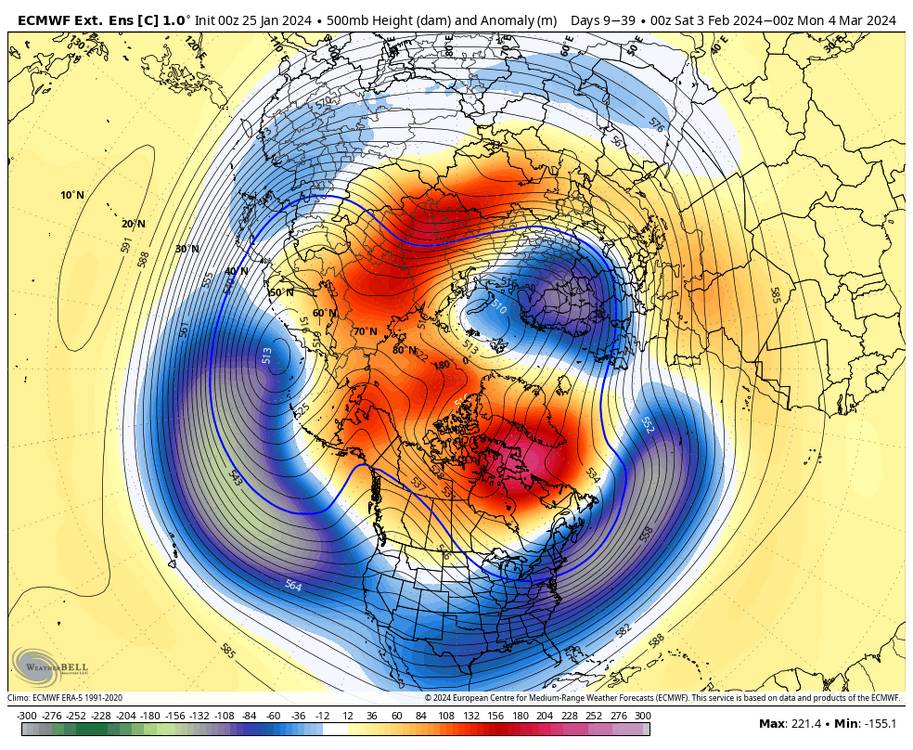
1 minute ago, GaWx said:
Take it with a grain/don’t trust it, but fwiw the new Euro Weeklies run is easily the coldest overall for mid Feb through early Mar. Once the BN temperatures set in Feb 12-19, they remain through the end of the run (Mar 4-11). The week of Feb 19-26 is by far the coldest for that week of any run yet and may, when also considering El Niño climo, have the most winter storm potential in the SE of any single week per this run with Miller A/GOM potential written all over it (combo of Aleutian Low/+PNA, -NAO, -AO, and moist subtropical flow/split flow):


With the info you have posted for El Niño February's this doesn't surprise me in the least. This matches up very well with some of the great February Niños.
-
2
-
-
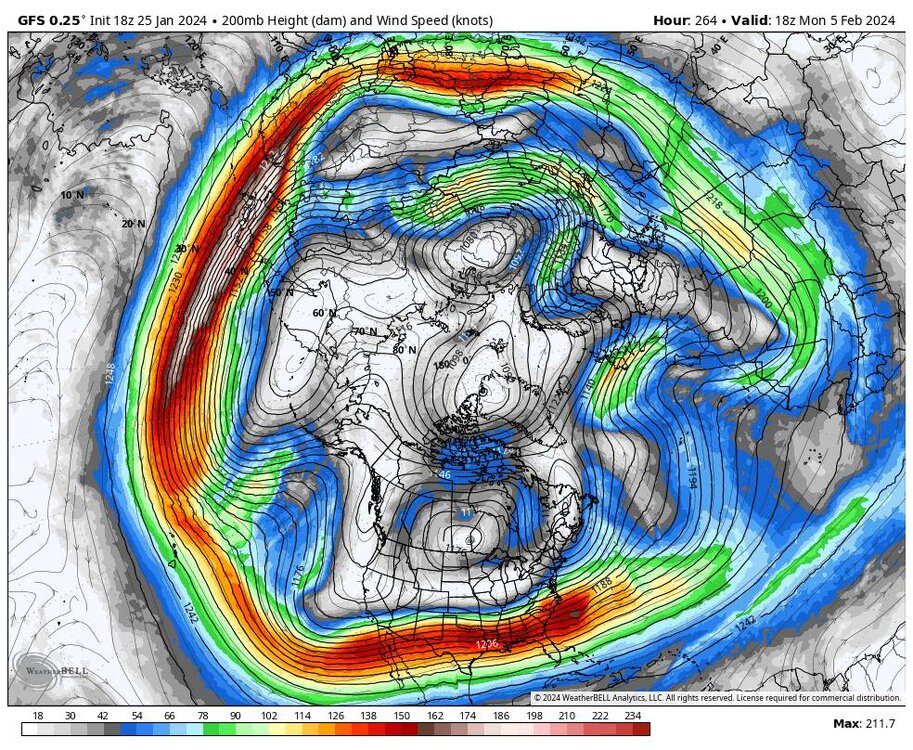
29 minutes ago, wncsnow said:
Look at this.. even if it doesn't snow in the next few weeks this weird pattern is going to be something to behold
.thumb.png.1f7c8e51351200186650110daeffa4b0.png)
The storms undercutting the ridge up north is going to bring us something. I mean the jet is going to be bringing in a ton of moisture. Heck we just need a thread the needle type storm.
-
1
-
-
51 minutes ago, wncsnow said:
Northern Mtns are going to rack up again
.thumb.png.02e24478ee551cefa8b9886eefd2396c.png)
Yeah after this weekend off to the races along the border.
-
3
-
-
Heck yeah I hit the gym today in shorts and a short sleeve shirt. Feels freaking great!
-
4
-
-
This could possibly turn into something bigger.
.thumb.jpg.4d1939fb501ab051bf3c904cbfd8a417.jpg)
Sent from my SM-G998U using Tapatalk -
Still a strong upslope signal also.
.thumb.jpg.00037edc8ca15220cd4ea387e3338be0.jpg)

Sent from my SM-G998U using Tapatalk-
1
-
-
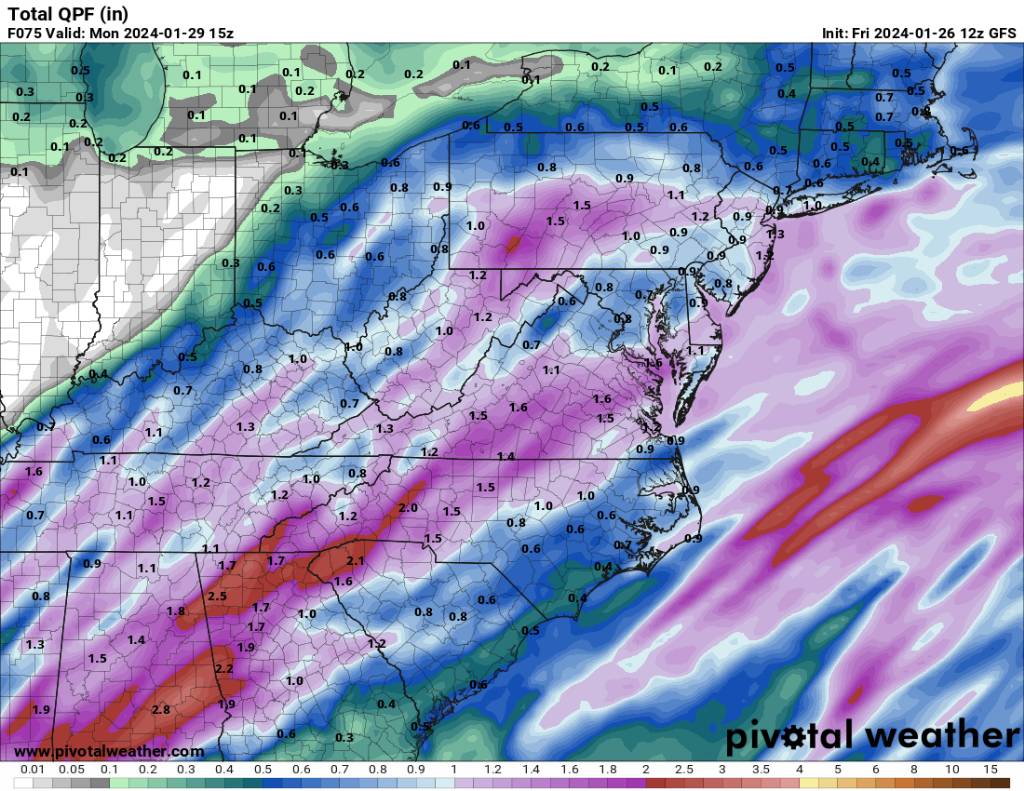
This weekend is going to be wet. Looks like another 1 to 3 inches of rainfall on top of the 1 to 3 we just got. Crazy how even Asheville has 7 inches of rainfall already this month.

.thumb.jpg.06b21441b7628d31ca29979da987d7ff.jpg)
Sent from my SM-G998U using Tapatalk-
 1
1
-
-
6 minutes ago, Daniel Boone said:
Yeah, we have a couple things warring against the MJO Phase. SSW affects instigating blocking. The Central Pac( modoki area) Convection enhancing the STJ. Even though the MJO is in the western area this helps to counter it.
The MJO hasn't really fully Bern a dominant factor this season. Been lot's of talk but we've had an eclectic number of pattern drivers throughout the season.
-
1
-
-
13 minutes ago, GaWx said:
Regarding the bolded, that would just make the already frustrated NC folks that much madder as that’s exactly what happened in the middle of this month. The sanitarium thread would be overwhelmed!
Hopefully the region would score and not just the mountains West. I know that is extremely frustrating.
-
1
-
-
This is about as good a look as your going to get. Just beautiful.
Sent from my SM-G998U using Tapatalk-
1
-
1
-
-
Look at the jet screaming out of the SW. This is classic NINO look. Although this is the STJ on roids.
Sent from my SM-G998U using Tapatalk-
1
-
-
Euro Weeklies are still a go. The EPS is still a go. I think we end up with a muted torch. Now does that mean snow? I haven't a clue. But if there is colder air around our chances will be better than an all out torch.
-
1
-
 1
1
-
-
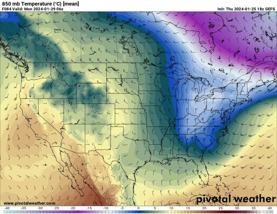
Then we have kind of a lagging trough in the NE to a much cooler pattern along the East Coast in general.
.thumb.jpg.82b39d8c92d910e414c63cce24365078.jpg)
.thumb.jpg.0acc59c25f66b838364c9eb1b061c6cf.jpg)
.thumb.jpg.3101bb89457e248136ae31f0e25eea92.jpg)
Sent from my SM-G998U using Tapatalk-
1
-
-
We then get another reinforced shot of cooler air behind the initial cool down.
.thumb.jpg.86a2f73aab0ac1ec17dbac1b8c4b1036.jpg)
.thumb.jpg.11be75d0b8f058069b19be4eb78c51c3.jpg)
Sent from my SM-G998U using Tapatalk-
1
-
-
We go from today to a nice cool down.
.thumb.jpg.b8ba8fa69097ff08da01dd52d054f737.jpg)
Sent from my SM-G998U using Tapatalk-
1
-
-
4 minutes ago, Coach McGuirk said:
Yeah, I don't think you can trust DT.
If you follow the ensembles they have cooled greatly just over the past few days.
-
3
-
-
11 minutes ago, WinstonSalemArlington said:
DT ALERT*:
⚠️**ALERT ** MAJOR CHANGES AT 500mb ACROSS NORTH AMERICA WILL END MILD PATTERN MUCH SOONER THAN INTIALLY THOUGHT⚠️
...as I said in the Tuesday edition of THIS WEEK IN WEEK ... this is called UNDERCUTTING
... rare PAMELA ANDERSON Pattern change ...
NEXT WEEK things are looking VERY different than what they appeared only 3-4 days ago. The 12z Models are showing some important changes.
…TENN VALLEY southern Mid Atlantic snowstorm FEB 4-5?
https://x.com/wxrisksnowstorm/status/1750697773140255145?s=46&t=5ny5bPgiX5Vy3bQMvYTY5g
The ensembles are catching onto this today as well. Doesn't look like an all out dumpster fire.
-
1
-
-
34 minutes ago, Tyler Penland said:
18z GFS certainly wasn't bad. I have a hard time buying any long term torch given the Nino and the fact that the models blasted a January torch back in December that never really materialized beyond some short warm ups.
If a February "torch" gives me another foot of snow I'll be thrilled.Yeah the torch has never materialized..We've been at or below normal essentially. I really don't think this so called torch will either. Glad I live in the mountains. I don't envy those that don't.
-
1 hour ago, Carvers Gap said:
This is going to really stress the limits of the thunder in the mountains rule. If it snows in ten days, I will never question the rule. I mean it works about 90% of the time. We can just throw out the Weeklies if it works this time. We will use thunder only for next winter if so.
Hey it does look like we will see a nice upslope even here the first of next week.
-
2
-
-
More rain tonight. The river is way up but I don't see any flooding concerns. Maybe this weekend though.
-
3 hours ago, ncjoaquin said:
The ones that need your sarcasm, met1985, probably would not even realize that you're being sarcastic, lol.
Hey I'm just trying to stay in my lane. Just living in reality lol.
-
 2
2
-

.png.0ed0d6423aaf94f60f325c183c76cdc1.png)
.png.0bdc8b3c4ae27dc170e37514bdd0f4ef.png)
.jpg.5b4131e2619b3d289990953525cd7c1a.jpg)

.jpg.694a6b5688c66e1136bdecaa4345ced3.jpg)
.jpg.55a95ab5c889fa3901f9976840d3ad2d.jpg)

.jpg.1b1cd56f1f09e042a647d28f896b9dda.jpg)
.jpg.8d93ea01707ca8cd3e5f8759108328fe.jpg)
.jpg.3a3fcea380edb77faf8e3f427d1d30be.jpg)
.jpg.f46b643605bb1cdbc9c45e213bbe87ab.jpg)
.jpg.43a692150f3effde6d002267aabe6751.jpg)
.jpg.fdef3a916c1157410d391a50ad74e34b.jpg)

February 2024 mid/ long range
in Tennessee Valley
Posted
Thank you.