

Met1985
-
Posts
14,079 -
Joined
-
Last visited
Content Type
Profiles
Blogs
Forums
American Weather
Media Demo
Store
Gallery
Posts posted by Met1985
-
-
Speaking of it's snowing in downtown Canton now.
-
 3
3
-
-
The flow has switched to a more traditional NW flow. You can tell the cloud deck is lowering and moisture is coming down.
-
1
-
-
Yep temp down to 36. Let the storm move in.
-
1
-
-
Just now, wncsnow said:
It is but generally the models have cut totals for Buncombe. It's going to be too warm tomorrow for it to stick in the lower elevations like Asheville. Whatever falls after dark will have a better shot at accumulating there. TN border will do great as usual. I'm just trying to see some snow at work Monday
I think honestly the snow doesn't start until dark anyways which will be much better for accumulation.
-
1
-
-
13 minutes ago, wncsnow said:
Wacky pattern coming up. Rare to see ridging this strong in Canada in the winter. Hopefully we all score at some point.
Yeah this is a highly anomalous pattern coming up. Will be interesting see how thing move around that big high pressure.
-
16 minutes ago, wncsnow said:
Here watching the short range cut totals for Asheville.
.thumb.png.4de64b64824eeb415e68a513713b7474.png)
Lol now you know the 3k NAM is crap at upslope snow. The 12k and gfs do look good.
-
28 minutes ago, NorthHillsWx said:
Delusional is coming to the sanitarium and expecting anything of substance
Shit I know I am.
-
1
-
 2
2
-
-
6 hours ago, TARHEELPROGRAMMER88 said:
I will be here in a few weeks when people start coming to reality on the blanking.
You are freaking delusional.
-
1
-
 1
1
-
-
The GEFS ENS looks great.

Sent from my SM-G998U using Tapatalk-
3
-
-
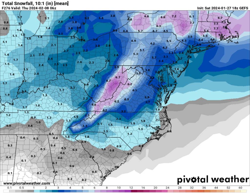
First event and first and the small second event in the middle of the week together.
.thumb.jpg.2f4ae3da770a50d13905ae68b43f9a0a.jpg)
.thumb.jpg.3bcd7c9876eef382837fbc487b4644c2.jpg)
Sent from my SM-G998U using Tapatalk-
1
-
 1
1
-
-
Still looks like a great event on the 18z short range models.
.thumb.jpg.c6d24c037b161f9aa3c0388f76a8e4b3.jpg)
Sent from my SM-G998U using Tapatalk-
1
-
1
-
-
7 minutes ago, Maggie Valley Steve said:
GSP going big for the Smokies...
URGENT - WINTER WEATHER MESSAGE
National Weather Service Greenville-Spartanburg SC
333 PM EST Sat Jan 27 2024

NCZ051-052-280445-
/O.NEW.KGSP.WS.W.0003.240128T1700Z-240129T1700Z/
Swain-Haywood-
333 PM EST Sat Jan 27 2024

...WINTER STORM WARNING IN EFFECT FROM NOON SUNDAY TO NOON EST
MONDAY ABOVE 3500 FEET...

* WHAT...Heavy mixed precipitation expected. Total snow
  accumulations of 2 to 6 inches at elevations of 3500 to 4500
  feet, and 6 to 9 inches above 4500 feet. Winds will gust 40 to 50
  mph.

* WHERE...High elevations of Swain and Haywood Counties, above
  3500 feet.

* WHEN...From noon Sunday to noon EST Monday.

* IMPACTS...Travel could be very difficult. The hazardous
  conditions could impact the morning commute. Gusty winds could
  bring down tree branches.
Oh heck yeah!
-
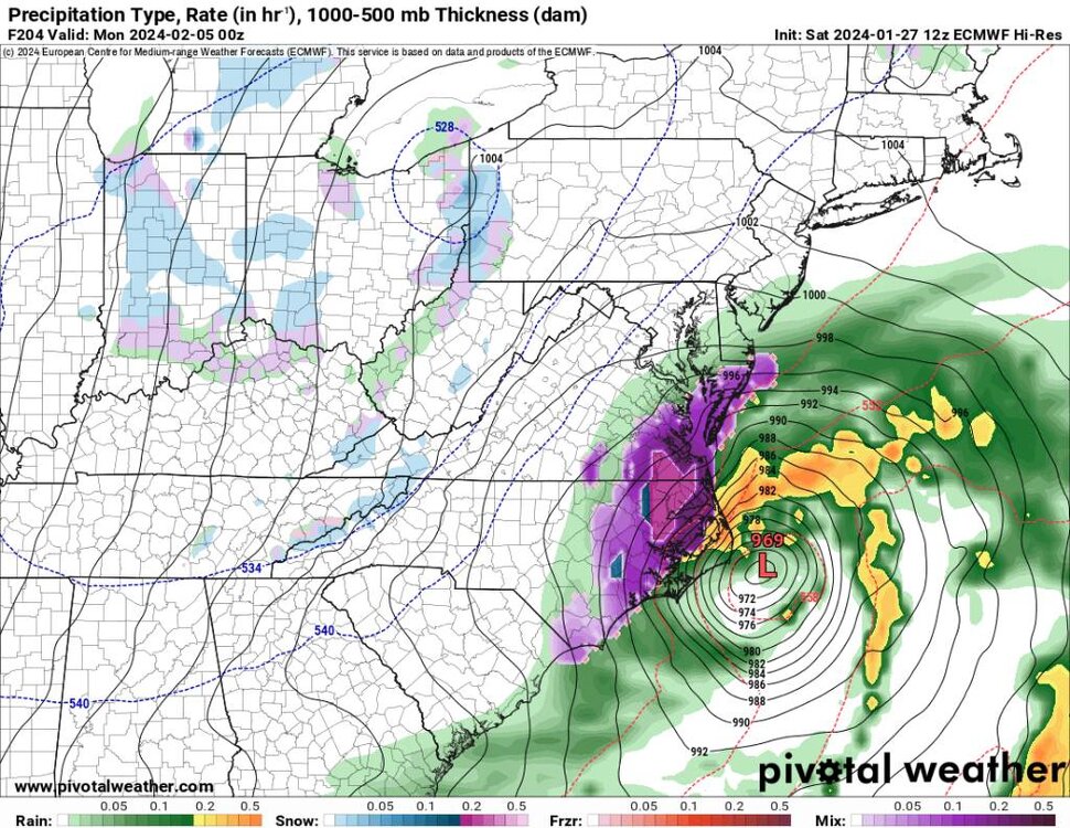
At the end of the Euro it starts snowing at hour 204 all the way to the end.
.thumb.jpg.64b04496760dd41d964c446a47cf53c5.jpg)
.thumb.jpg.334383b6eb97d660b42a2d4b470c9506.jpg)
Sent from my SM-G998U using Tapatalk-
2
-
-
Guys I'd be excited with so much energy flying around. Something will hit.
-
3
-
-
The end of the Euro is freaking wild.
-
I tell yall after this weekend things are going to ramp up big time. Just a ton of energy is going to be flying around.
-
2
-
-
1 minute ago, Tyler Penland said:1 hour ago, Met1985 said:Tyler let us just fantasize a little bit lol.
Hey I thought 8-12 was pretty solid lol
Oh no doubt. This looks like a great event.
-
Here yall go.
Sent from my SM-G998U using Tapatalk -
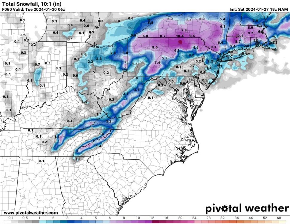
NAM and the gfs look great for the upcoming event.
.thumb.jpg.8227b2e76a24e5c849c21797dcc8b5ac.jpg)
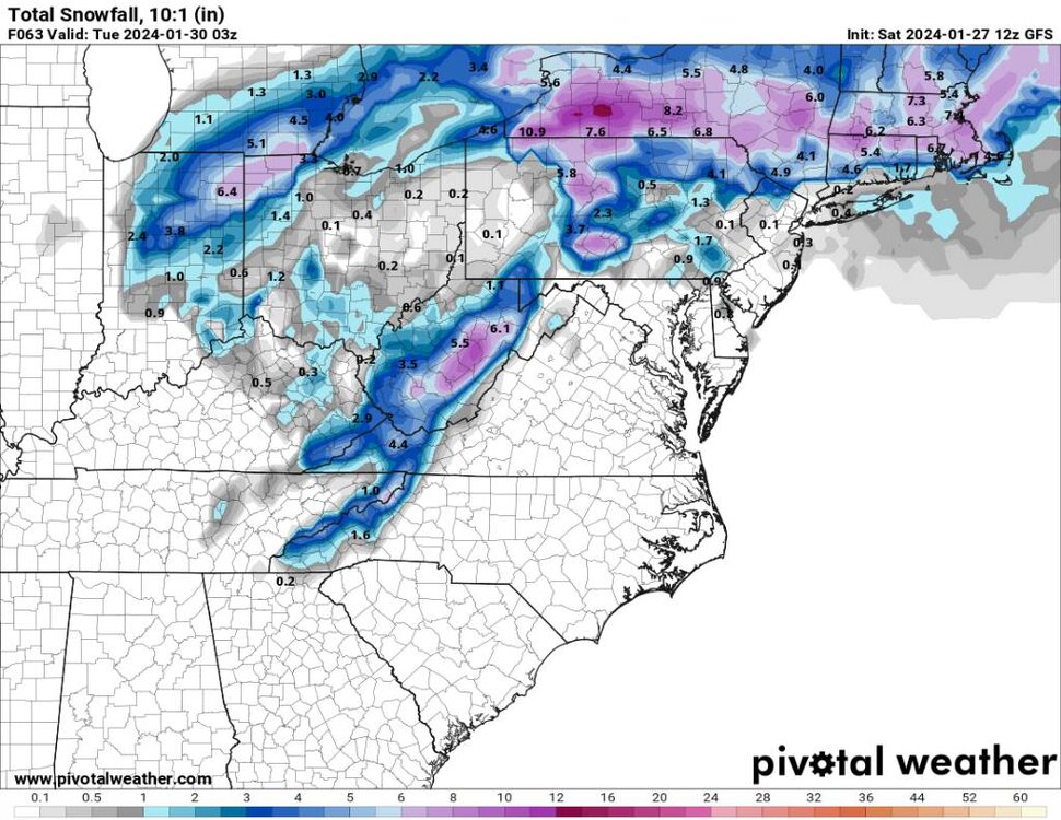
Sent from my SM-G998U using Tapatalk-
3
-
-
26 minutes ago, Amos83 said:
What do you think guys, is it worth heading up to beech mountain tomorrow through Tuesday? Thinking about taking the kid up to see some snow if it will be decent
Yes sir this looks like a solid event.
-
19 minutes ago, Tyler Penland said:2 hours ago, BooneWX said:Are my eyes deceiving me or is the NAM suggesting the smokies get smokied by 30+ inches??
It likes to do that. Definitely take it with a grain of salt. Probably cut those numbers by 1/3 but still a solid 8-12" event.
Tyler let us just fantasize a little bit lol.
-
3
-
3
-
-
15 minutes ago, BooneWX said:
Are my eyes deceiving me or is the NAM suggesting the smokies get smokied by 30+ inches??
Yes sir!
-
15 minutes ago, BooneWX said:
Are my eyes deceiving me or is the NAM suggesting the smokies get smokied by 30+ inches??
Yep. Crazy.
-
1
-
-
45 minutes ago, CAD_Wedge_NC said:
I thought you were done with this winter... you implied that it was over.... have you repented of your sins?
No kidding! The whiplash in this thread is for weenies....
.png.5bb31d9df5c0ea0293f7a9387104d220.png)
.jpg.a469cf2b0d1a0b92edebd79d764c426d.jpg)
.jpg.cb312ab75710312de9481f74b9a660ac.jpg)
.jpg.6afda2b91dd6f97fdd348ca776a32d28.jpg)

.jpg.9ca921cf66d48e3042963a4ced0a599b.jpg)
.jpg.567d3beaf09cf85d53fd3535da1c6a76.jpg)

.jpg.277c0ce5ff053ce3d4f20569ac710ddc.jpg)

2023-2024 Fall/Winter Mountain Thread
in Southeastern States
Posted
Yeah it really picked up in town.