

Met1985
-
Posts
16,909 -
Joined
-
Last visited
Content Type
Profiles
Blogs
Forums
American Weather
Media Demo
Store
Gallery
Everything posted by Met1985
-

2023-2024 Fall/Winter Mountain Thread
Met1985 replied to The Alchemist's topic in Southeastern States
A ton of water on the road and pouring the rain. -
2023-2024 Fall/Winter Mountain Thread
Met1985 replied to The Alchemist's topic in Southeastern States
Don't fret the 00z euro. It will change and I still think we are in a great position. -
2023-2024 Fall/Winter Mountain Thread
Met1985 replied to The Alchemist's topic in Southeastern States
Temp has dropped to 32 with a rain snow mix. You can see the bright banding on the radar. -
2023-2024 Fall/Winter Mountain Thread
Met1985 replied to The Alchemist's topic in Southeastern States
Yep small positive adjustments. Sent from my SM-G998U using Tapatalk.thumb.jpg.e920fae2963e62808fb0f20f9f9b61b8.jpg)
.thumb.jpg.89b59b080f0c0fa5f00f3c9fd47c5606.jpg)
.thumb.jpg.bd2fc760b8215f7b3009b3a2d0a3ab20.jpg)
.thumb.jpg.bb0f2553263d628a52ca04c8c8b25812.jpg)

-
2023-2024 Fall/Winter Mountain Thread
Met1985 replied to The Alchemist's topic in Southeastern States
Yeah the wind here has been steadily climbing all evening into tonight. Not real exciting about tonight. -
2023-2024 Fall/Winter Mountain Thread
Met1985 replied to The Alchemist's topic in Southeastern States
Power is out at my house. I noticed there are Power outages showing up already. -
2023-2024 Fall/Winter Mountain Thread
Met1985 replied to The Alchemist's topic in Southeastern States
Meh don't get that vested. Yeah we all want snow. Heck I'd give my left kidney for another superstorm like 1993. But we still have several weeks. I mean I really do think we may have something brewing next week. -
2023-2024 Fall/Winter Mountain Thread
Met1985 replied to The Alchemist's topic in Southeastern States
I'll put it like this. It's weather. Can we control it? This is a hobby and if you can't handle it then take a break. Mother nature doesn't give two shits what you want or how you feel... Just plain and simple. If this current pattern is making you angry then I suggest you take a break from it because there's nothing we can do but look outside and see what it's doing. And yeah it can still snow in March lol. -
2023-2024 Fall/Winter Mountain Thread
Met1985 replied to The Alchemist's topic in Southeastern States
If we do have a ridge then that means our spring will be delayed. I'm afraid we are in a decade long bad winter pattern or could be several other variables but I personally am not ready to write winter off just yet. I've as well seen forecasters predict a great February pattern. So who knows. You know these long range forecasts are hard to nail down. -
2023-2024 Fall/Winter Mountain Thread
Met1985 replied to The Alchemist's topic in Southeastern States
It's only January 8th. I've seen several winter's we're we score big in February. Not saying we will have to wait that long but February is a winter month that I think people have forgotten. -
2023-2024 Fall/Winter Mountain Thread
Met1985 replied to The Alchemist's topic in Southeastern States
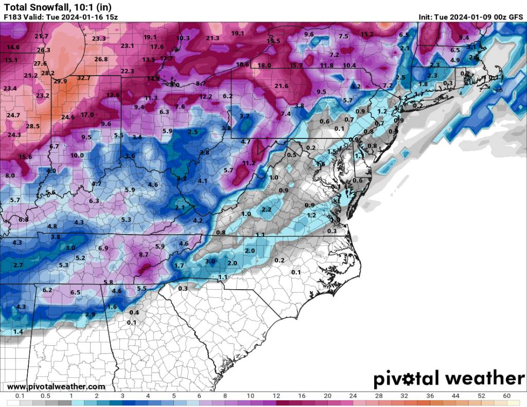
Very impressive. Sent from my SM-G998U using Tapatalk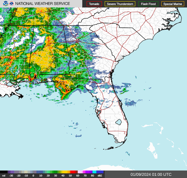
-
2023-2024 Fall/Winter Mountain Thread
Met1985 replied to The Alchemist's topic in Southeastern States
I wouldn't worry. Still a lot of adjustments that are going to be made. -
2023-2024 Fall/Winter Mountain Thread
Met1985 replied to The Alchemist's topic in Southeastern States
Yeah there are already several closures and several that are on a two hour delay here in WNC. -
2023-2024 Fall/Winter Mountain Thread
Met1985 replied to The Alchemist's topic in Southeastern States
Also the moisture coming from the gulf looks very impressive. I'm afraid that there are going to be a lot of power outages coming by tomorrow morning especially with the high winds and possibly embedded storms. -
2023-2024 Fall/Winter Mountain Thread
Met1985 replied to The Alchemist's topic in Southeastern States
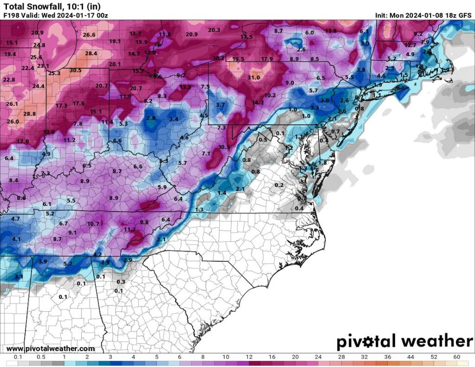
Euro Weeklies look for the end of January and first of February. -
2023-2024 Fall/Winter Mountain Thread
Met1985 replied to The Alchemist's topic in Southeastern States
I think we are in a good position. We will have the cold and some moisture to work with next week. Things will hit right. -
2023-2024 Fall/Winter Mountain Thread
Met1985 replied to The Alchemist's topic in Southeastern States
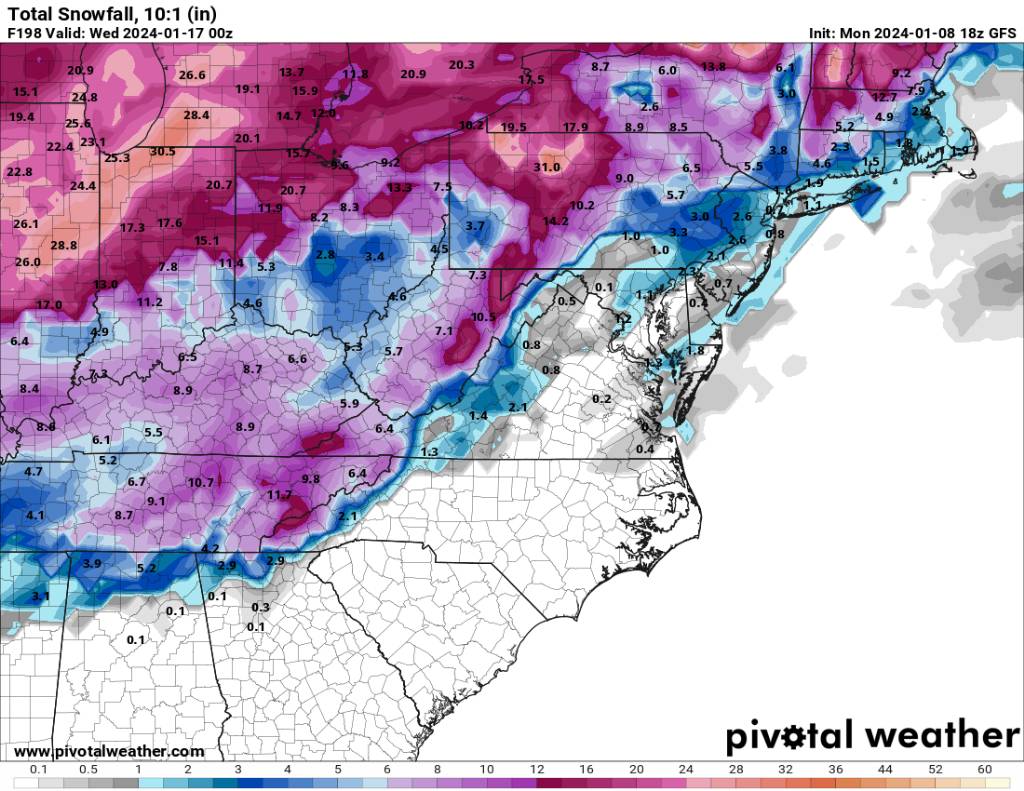
This isn't a bad look at this timeframe. Sent from my SM-G998U using Tapatalk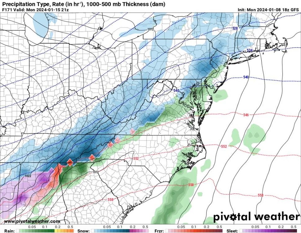
.thumb.jpg.c9718da2b2b149b0b9757a9de59a60ec.jpg)
-
2023-2024 Fall/Winter Mountain Thread
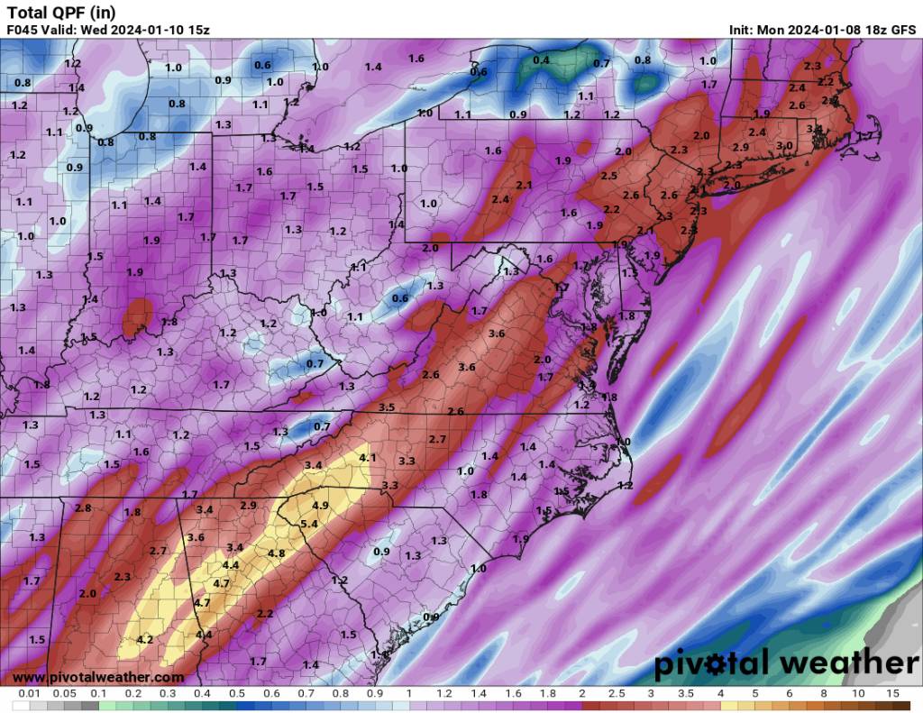
Met1985 replied to The Alchemist's topic in Southeastern States
Rainfall totals keep increasing. Sent from my SM-G998U using Tapatalk
-
2023-2024 Fall/Winter Mountain Thread
Met1985 replied to The Alchemist's topic in Southeastern States
Yeah the wind has already started gusting here. -
2023-2024 Fall/Winter Mountain Thread
Met1985 replied to The Alchemist's topic in Southeastern States
Down to 38 here but I suck at CAD. looking forward to the tornadoes lol. -
2023-2024 Fall/Winter Mountain Thread
Met1985 replied to The Alchemist's topic in Southeastern States
Flood watch issued for just about everyone in the mountains. -
Looks like a NINA pattern.
-
2023-2024 Fall/Winter Mountain Thread
Met1985 replied to The Alchemist's topic in Southeastern States
Yeah I think you are right. That and some high winds. Fun times. -
2023-2024 Fall/Winter Mountain Thread
Met1985 replied to The Alchemist's topic in Southeastern States
A beautiful cold morning with a low of 18. -
2023-2024 Fall/Winter Mountain Thread
Met1985 replied to The Alchemist's topic in Southeastern States
06z gefs doesn't agree with the op. Sent from my SM-G998U using Tapatalk.thumb.jpg.471126d870cbb9e757a749f6c236d86e.jpg)
.thumb.jpg.c696649f1844b9d27de7af1849f9d2a5.jpg)
.thumb.jpg.0673da2b808990baf2acec7434277b47.jpg)

.jpg.a838c50e3c6e42bb3bd87cd1851c544d.jpg)
.jpg.7cf586781c80ec00e54a7266eb3740d9.jpg)
.jpg.a556373157791b3f6429ffd1e9d829c7.jpg)
.jpg.fb83e8bc5112c2174bf8af257a9a3c99.jpg)


.jpg.87f6795576a94b94d3ee60a3741ff6bb.jpg)


.jpg.0f489eedaf484b46b51c94a8c5ec78f2.jpg)
.jpg.05cdffdfe7eea10f24b24615ccbdaa99.jpg)
.jpg.88541b2c705982431b9c6e0e91ce169b.jpg)