

RogueWaves
-
Posts
2,559 -
Joined
-
Last visited
About RogueWaves

- Birthday 09/13/1964
Recent Profile Visitors
8,794 profile views


-
Actually, the last plowed snows were back on 3/18 and it's been above freezing almost every day since. I'm surprised and unhappy how stubborn the piles at work have been. And they were mostly just from the winter 2.0 that we got between 3/13-18. The ground being very frozen helped that. Open water on our lake in Harrison just happened maybe a week ago - that has boosted the mood after looking at solid ice for months. My golf buddy near Mackinaw had 40" of snow from those back-to-back storms. Last weekend his place was still snow covered while I played an early first round in Clare. He's tired of winter too.
-
Full sun and 60 degrees today - drifts are finished - down to plow piles. At work in Grayling some of those are taller than a pick-up truck tho.
-
You put into words my exact sentiment of how this spring has rolled up here to date. One or two days of sun with AN temps just to crash back into 10 days of winter or near winter and endless streaks of gloom. And now a white Easter to kick the nuts again.
-
11.6" here which is 2.6" AN
-
1.4" of large flakes at home, double that in Grayling. 11.4" for March, 67.6" for the season which is 115% of a normal season here and my first AN season in 7 winters. I moved so they were not all here fwiw. Drift on the balcony keeps getting deeper, lol.
-
Have you at least made a day trip up further in The Northland during winter to see the truly deep stuff?
-
I've lived back-to-back 220+ winters at my old home further north. It can and will give a guy cabin fever. Then there's his level of winter which is a whole other planet I don't want endure, lol.
-
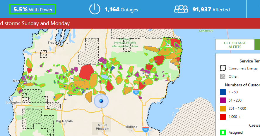
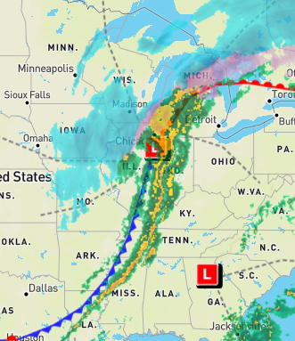
Last March it was more N Central and NEMI (NWMI was spared). This time its a coast-to-coast battle zone of ice that I will be commuting thru in the morning. Latest map (7 pm)
-
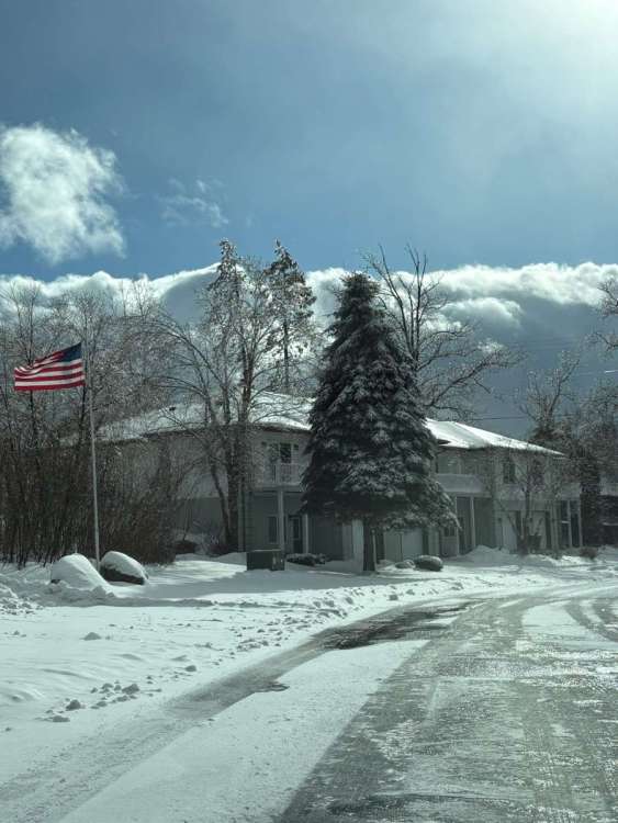
Just got the backside winds (50+ gusts) and squalls plus 1.5" of lake stuff that fell today. Could barely see across the street. Less than a week ago I was swinging my clubs in short sleeves. Since then 9.5" of snow and at least 0.25" of ice with some short-term bliz conditions for good measure. Happy MET spring!
- 716 replies
-
- 10
-

-
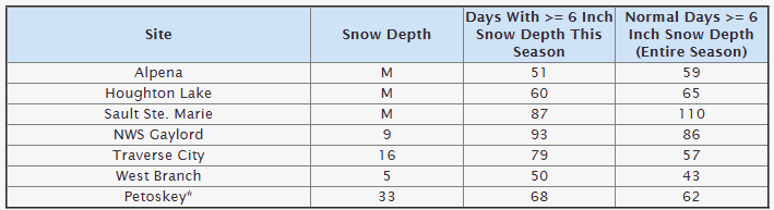
APX has chosen 6" as the min depth to tally-up on their snow page. They don't break it down lower. Most including West Branch already have more than a typical season total. Hope this explains.
-
I'm likely getting a "storm day" off of work tomorrow. Grayling may be taking it hard again in the ice storm dept. Preliminary Local Storm Report National Weather Service Gaylord MI 1051 PM EDT Sun Mar 15 2026 ..TIME... ...EVENT... ...CITY LOCATION... ...LAT.LON... ..DATE... ....MAG.... ..COUNTY LOCATION..ST.. ...SOURCE.... ..REMARKS.. 1040 PM Freezing Rain Houghton Lake 44.30N 84.76W 03/15/2026 U0.00 Inch Roscommon MI Amateur Radio Trees and large limbs are being downed by ice.
-
I'd say yes to the 3+ question. Stations in NMI use number of days with 6+ as their standard. The nearest station reporting such is about 20 miles due east of me. All NMI stations are AN season to date, even non-LES locales such as my own. Big storms (warning level) and deep snow are my key winter likes. Deep cold that may excite you and others, I actually deduct points for, lol. Lake has been iced since early December. I haven't had a daily high at or below freezing since March 1st yet somehow I have solid snow cover here from back to back storms. Meanwhile, DTW hit 70F today. It's pretty wild.
-
Anyone else reminded of Oct 19th?
-
9.5 in December right before the pull-back. Nearly that (9+) later in Feb again right before the final thaw-off. Windy storms have made measurement a challenge but Harrison has had 8.5-9" since Friday, and I went from a bare balcony to now a 10" drift. Looks like mid-January again out there and I was ready for spring tbh. This from APX is not nice - so glad to miss this round of ice. 32F attm here at home. Unfortunately, whoever gets into the heavier freezing rain will likely see significant impacts...to include power outages and tree damage...with both of these being exacerbated by increasingly gusty winds during the day Monday. And, unlike last years historic ice storm, the ground temperatures are several degrees colder with this event...supporting very icy driving conditions as well.
-
For mby? 4+ melting down to puddles, then the backside blasting thru making a frozen mess of everything for several days. Then spring happens next weekend. The Robins are not too pleased with back-2-back storms greeting their arrival.


