usedtobe
-
Posts
8,812 -
Joined
-
Last visited
Content Type
Profiles
Blogs
Forums
American Weather
Media Demo
Store
Gallery
Everything posted by usedtobe
-
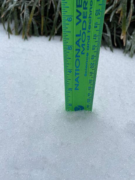
Measured around 1.5" of sleet at multiple points on my sidewalk. The most sleet I've had since 1994.
-
Rain at 7AM turned to snow by 7:15. The mulch and grass have caved with my temp at 34.3.
-

Jan 31st - 33rd Storm Obs and Disco like it's 1979
usedtobe replied to Bob Chill's topic in Mid Atlantic
Could Capital Weather Gang use your picture with the branch and ruler? I'm not sure they'll use it bu think it's a good one. -
January Storm Term Threat Discussions (Day 3 - Day 7)
usedtobe replied to WxUSAF's topic in Mid Atlantic
I think the 00Z UKMET if extended would be good. It has the primary low in Kentucky and the secondary forming in eastern NC with you under a pretty good wedge. -
Rates alone can't but if the atmosphere above is dry, as the snow melts and evaporates the column can cool and help turn the rain to snow. That's what the models have been advertising.
-
January Storm Term Threat Discussions (Day 3 - Day 7)
usedtobe replied to WxUSAF's topic in Mid Atlantic
Don't we wish. The Euro slid back but not as far as the UKMET. The 06Z Euro ensembles only give us a 10 to 20 percent chance of 3 inches. The 06Z GEFS loves us. Why do I think it better to be with the UKMET and Euro? Still too early to give up. I still write for the post so that limits me from saying too much until we post our article. -
January Storm Term Threat Discussions (Day 3 - Day 7)
usedtobe replied to WxUSAF's topic in Mid Atlantic
It is pretty good step towards the GFS. Below is a comparison of 00Z 500h and the 12Z. Note how much more ridging takes place ahead of the vort and associated trof and what has happened over Maine. The latter has relaxed allowing more room for our approaching trough. If it relaxes a tad more we might get development a little farther west and more precipitation. There is that pesky impulse ahead of the trof, if it were to minor out quicker that would also help.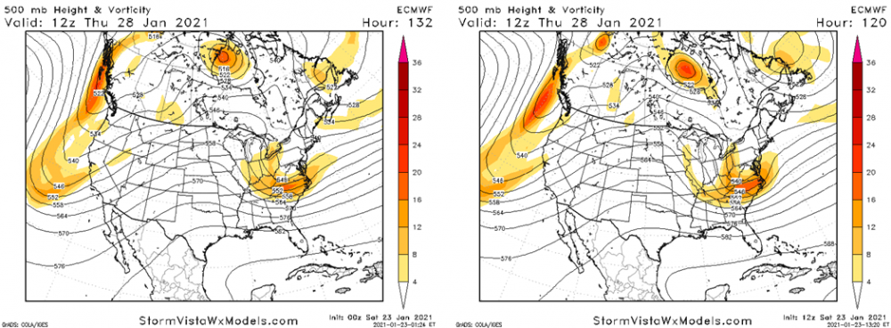
-
January Storm Term Threat Discussions (Day 3 - Day 7)
usedtobe replied to WxUSAF's topic in Mid Atlantic
The 18Z GFS sure is encouraging. It's not back to yesterday's Euro, but gives me 11". -
January Storm Term Threat Discussions (Day 3 - Day 7)
usedtobe replied to WxUSAF's topic in Mid Atlantic
Well occasionally. Unfortunately, the Euro ensemble mean for the 28th looks pretty bad. I haven't given up on the 28th but would feel better if the Euro and UKMET were on my side than the Canadian and GFS. -
January Storm Term Threat Discussions (Day 3 - Day 7)
usedtobe replied to WxUSAF's topic in Mid Atlantic
One of the problems that is just as important as the weaker ridge behind it is the upper pattern over New England won't allow enough room for a shortwave ridge to form ahead of the trough which keeps it from strengthening and in a sense shears it a bit while also reducing the upper level divergence in advance of the trough compared to what would happen with more room and a better shortwave ridge. That prevents our surface low from getting very far north. At least that's my take. Weaken or shove the troughiness over the northeast a little farther east and we'd be OK. At least I think we'd be OK. Slow the eastward movement of the trof would help do the same thing. -
January Storm Term Threat Discussions (Day 3 - Day 7)
usedtobe replied to WxUSAF's topic in Mid Atlantic
It does differ but still offers no snow, looks like freezing rain. It does have another possible weird looking snow event later in the month but the surface looks really strange. The euro does offer some front end snow but with the surface track and development its got, I'm not sure I buy but hope it's right. -
January Storm Term Threat Discussions (Day 3 - Day 7)
usedtobe replied to WxUSAF's topic in Mid Atlantic
Unfortunately the Canadian also is onboard the GFS express. It looks much different over Canada at 500h but not enough. I'm supposed to be a Winter weather Expert and the last two years, there has been no storms to write about. -
My ranking PDI Feb 5-6 2010 Dec 2009 1996 blizzard Feb 1958 March 1958
-
I remember having a long running thread on the pattern. I know i had one for the Feb storm but think I also had one prior to this one as the pattern was a great one with the superens D+8 really pitting out a number of good storm analogs. However, the models kept the low suppressed until around day 3 when the ens mean had a 500 pattern almost identical to the DC 8" or greater composite. Shortly after that I think Don Sutherland started comparing it to the knickerbocker storm. I tried finding the thread from eastern but could only find my thread on the feb 5/6 storm not the Deec one.
-
I thought i interesting that the CIPPS analogs identified 1983 as the top analog for the dec 2009 storm and the feb 6th 2010 one. The 2010 storm would have had the dec event as a top analogs but it was not yet int he data base.
-
This is probably already somewhere in the thread but I had saved it and early in the week looked at it. Fun memories from eastern http://www.easternuswx.com/bb/index.php?/topic/221595-widespread-20-inch-plus-amounts-verified/
-
Pretty much for us, I think new england can get a big one without it.
-
Weather References and Newbie Information
usedtobe replied to burgertime's topic in Southeastern States
Plus newbies need to know that the 850 temp is at around 5000 ft so the surface temps can often be above freezing when the 850 temps would indicate snow. Also, a warm layer during sleet events often develops above 850mb. -
But by 9:00 Am Feb 2nd the models were getting pretty adament except for a rogue run or two of the nam. On the second I wrote. "I talked to my friend Rich Grumm and he noted that the ensembles were showing an 90% chance of a foot of snow over my house" Ensemble systems often do not have enough spread but from that point on the ens system was emphatic about getting a major snowstorm. That's really rare.
-
I have some of the images from then though I think I've blown some of them away. It is fun reading the threads. I looked for the Dec 19th thread but couldn't find it. That was an exciting period when we all got along well because optimism and weenism ruled.
-
I think so but I wasn't as optimistic for dc for that storm since it was a miller b evolution. I don't think I saved that thread, only the dec and feb 5-6 ones.
-
Here's my eastern tread leading up to the storm. I doubt we'll ever see another stretch comparable to Jan 31 thru Feb 11 http://www.easternus...ounts-verified/
-
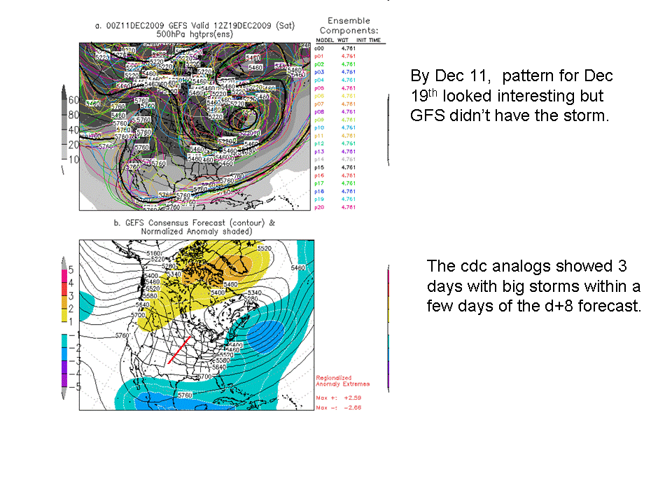
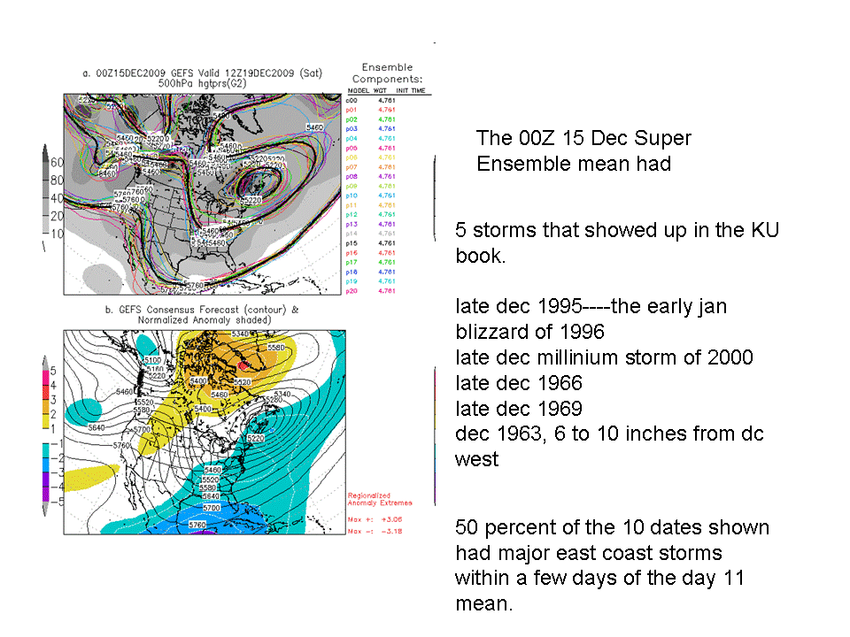
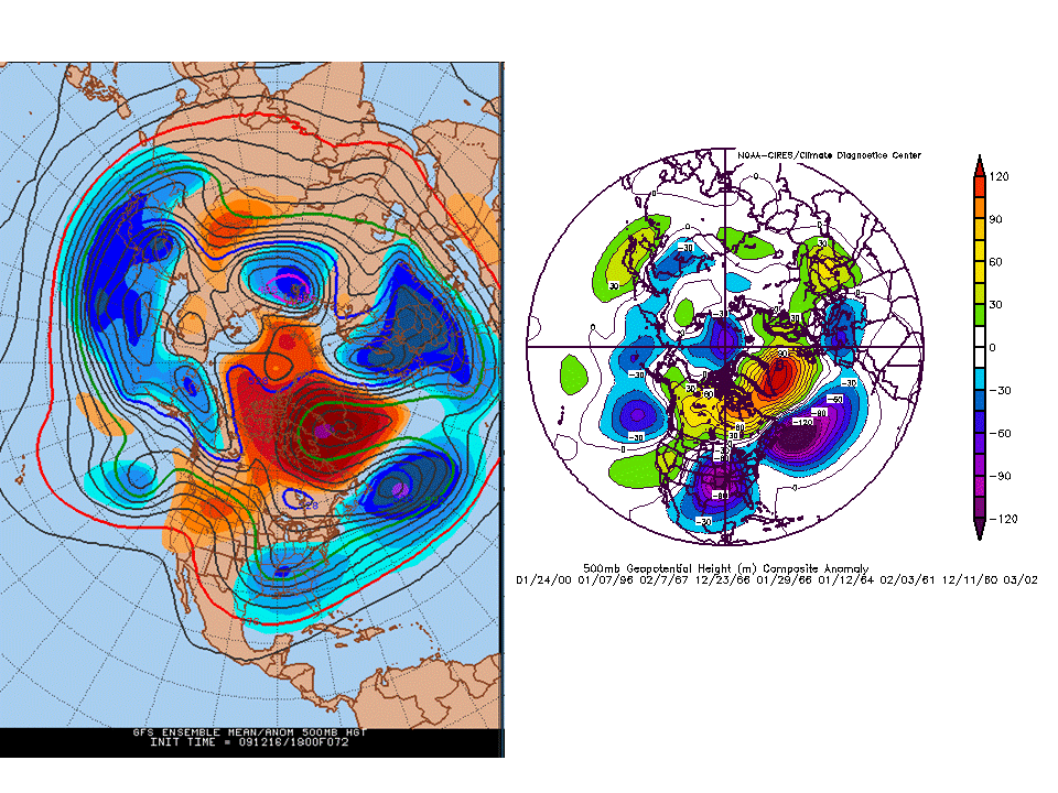
I remember really being stoked by pattern and talking quite awhile about the potential for a KU storm since the pattern was looking so favorable. By the 11th, The D+8 CPC analogs identified 3 KU storms within several days of the centered mean. By the 14 or 15 the number had jumped up to 5 inclduing some really famous events. By 72 the esnemble mean pattern was almost identical to KU storms that produced over 8 inches at DCA. It was actually a storm I was bullish about despite having a non-bullish rep.
-
Reconsider majoring in meteorology!
usedtobe replied to stormguy80's topic in Weather Forecasting and Discussion
Yes as would the ukmet guys as their model scores better than the GFS. Most offices I think have journeyman and interns so there is a place to learn forecasting. Plus, I think the training of the NWS is better on average than in the private sector. There are training modules and the Weather Event Simulator (http://www.wdtb.noaa.gov/tools/wes/index.htm) where they can work on canned forecast problems. -
Reconsider majoring in meteorology!
usedtobe replied to stormguy80's topic in Weather Forecasting and Discussion
Good for you, do you still live in Calvert County?