
.jpeg.88e30b1573920286ceacf89f239564d2.jpeg)
wolfie09
-
Posts
17,315 -
Joined
-
Last visited
Content Type
Profiles
Blogs
Forums
American Weather
Media Demo
Store
Gallery
Everything posted by wolfie09
-
.thumb.jpeg.b9e232a6b43e01b7eeee3144246db864.jpeg) We are back to snow here this morning, light but steady, had around 2"-3" of shaved ice last night.. Highest report I found in N Oswego is 4" lol NWS has another 4"-8" throughout the day and most SR guidance has 4"-6"+ on the backside, we'll see how that turns out..
We are back to snow here this morning, light but steady, had around 2"-3" of shaved ice last night.. Highest report I found in N Oswego is 4" lol NWS has another 4"-8" throughout the day and most SR guidance has 4"-6"+ on the backside, we'll see how that turns out.. -
Sums up my night
-
Yeah same here, just looking outside it looks like snow but I can definitely hear something, it's just not sleet or graupel lol I'm also getting some bigger flakes mixing in..
-
Not what I wanted to hear lol The latest 00Z 1/17 NAM has trended colder with surface temperatures as well but sends a warm pocket of air at 850 mb northwestward across the region for a time around midnight. Also a warm nose advances northward from the 850 and 925 mb levels northwest as well through the region. So far the NAM,RGEM and HRRR have a decent handle of the warm layer while the 18Z GFS 1/16 is too cold.
-
Hard to see on that radar..
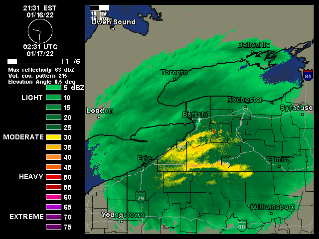
-
Look how the mix follows the heavier precipitation lol Hrrr doing the same thing..
-
Here is the 3k for 2-3 am.
-
Yeah and most of it will probably be sleet for CNY lol I don't think the NAM is wrong here..
-
Widespread Snow Potential January 16th to January 18th
wolfie09 replied to sferic's topic in Upstate New York/Pennsylvania
Yeah Hrrr continues to trend warmer although it's relatively short lived (hr or two), at least as of now lol -
Widespread Snow Potential January 16th to January 18th
wolfie09 replied to sferic's topic in Upstate New York/Pennsylvania
Just a little more NW and we got our climo track lol -
Widespread Snow Potential January 16th to January 18th
wolfie09 replied to sferic's topic in Upstate New York/Pennsylvania
-
Widespread Snow Potential January 16th to January 18th
wolfie09 replied to sferic's topic in Upstate New York/Pennsylvania
The image I posted was 1 am, do you have that sounding? Either way should be brief if mixing gets out that way.. -
Widespread Snow Potential January 16th to January 18th
wolfie09 replied to sferic's topic in Upstate New York/Pennsylvania
Rgem also has 850s above 0c for a time right when that precipitation is entering.. -
Widespread Snow Potential January 16th to January 18th
wolfie09 replied to sferic's topic in Upstate New York/Pennsylvania
Nam meh lol -
Well at least I can catch up on some sleep lol
-
Widespread Snow Potential January 16th to January 18th
wolfie09 replied to sferic's topic in Upstate New York/Pennsylvania
I think first pingers will between midnight and 1am, lasting possibly a couple hours before transitioning to light snow and dry slotting.. -
Widespread Snow Potential January 16th to January 18th
wolfie09 replied to sferic's topic in Upstate New York/Pennsylvania
Here's the exact numbers .I went up around 2".. -
Widespread Snow Potential January 16th to January 18th
wolfie09 replied to sferic's topic in Upstate New York/Pennsylvania
There has been little change in the 12Z model consensus. Snow will move in slightly faster (perhaps an hour), but models continue to show a major winter storm impacting the area. Raised storm total snow amounts slightly east of Lake Ontario, but only by an inch or two. This area will be close to a dry slot in the storm system Monday morning, but 12Z models show a bit more QPF before the dry slot moves in. -
Widespread Snow Potential January 16th to January 18th
wolfie09 replied to sferic's topic in Upstate New York/Pennsylvania
Or they could be riding the hrrr haha.. Continues to show over an inch precipitation just by morning.. -
Widespread Snow Potential January 16th to January 18th
wolfie09 replied to sferic's topic in Upstate New York/Pennsylvania
Why do they do this to me lol Especially with the models showing sleet during heaviest precipitation..Hrrr does have 1.5" liquid overnight, couple hours of sleet, hope that verifies, which it won't lol -
Widespread Snow Potential January 16th to January 18th
wolfie09 replied to sferic's topic in Upstate New York/Pennsylvania
Looks like the banding is creating warmth? Mixing seems to follow it north.. -
Widespread Snow Potential January 16th to January 18th
wolfie09 replied to sferic's topic in Upstate New York/Pennsylvania
Hrrr continues to look better than the rgem/euro but it's definitely marginal..Well we'll know soon enough lol -
Widespread Snow Potential January 16th to January 18th
wolfie09 replied to sferic's topic in Upstate New York/Pennsylvania
Euro is pretty close to rgem at 1Am.. -
Widespread Snow Potential January 16th to January 18th
wolfie09 replied to sferic's topic in Upstate New York/Pennsylvania
Need to start looking at temps and we can't see in-between frames.. -
Widespread Snow Potential January 16th to January 18th
wolfie09 replied to sferic's topic in Upstate New York/Pennsylvania
Well if the rgem verified we would lose a decent amount of precipitation to mixing.. During the heaviest portion of the event..


