

Chicago WX
-
Posts
18,285 -
Joined
Content Type
Profiles
Blogs
Forums
American Weather
Media Demo
Store
Gallery
Posts posted by Chicago WX
-
-
15 minutes ago, ILSNOW said:
Euro goes south and east

This is a clown show.
I guess MBY being on the line of various model solutions, I've noticed the shifts more, but come on...
-
10 minutes ago, WestMichigan said:
RAP looks more like the NAM than the GFS.
RAP is always amped way northwest at this range. Same with the HRRR usually. Wouldn’t put any trust in it until like 12 hours out. Just my opinion of course.
-
17 minutes ago, Malacka11 said:
That’s f*cking brutal
-
 1
1
-
 1
1
-
-
NAM has 10” for KMCI. GFS has them smoking cirrus.

-
6 minutes ago, cyclone77 said:
This literally made me lol. Deep low in southern Indiana with cold rain to the north.

RGEM a trash model, but this depiction is believable. Airmass is garbage. Look at most models, areas to the west that miss out are sitting in the mid 40's on Friday. It's all dynamic cooling for those that see any snow. And even then, temps are like 32-34. It's probably going to be a much more narrow snow band than being shown. Of course for who...who knows.

-
White flag time. Euro and NAM teaming up. Deadly combo. Gonna be a good one for CID, MSN, MKE, and GRB. The usual suspects. Probably not enough time for MSP to reel this one in, but who knows.
I can’t wait until we go suppression depression in mid March. Enough of the f*cking rain.
-
34 minutes ago, King James said:
Was hoping we could add on to our whopping 4 inch total for the season but looks like we may escape this winter with less than a half of foot total of snow. Spring can’t come soon enough
9.9” on the season here, but point stands. Awful winter. Alas, we’re cooked here with this system. Just another 34 and heavy rain incoming. Terrible, terrible, terrible…
-
6z NAM is one for the books. 23" in 6 hours in Iowa. I mean, come on.
We're still a ways away from verification, but a little credit to the GFS so far. It's been closer to what's being modeled than the other models. Certainly not perfect though. Euro has been junk again. From the southern outlier to now the northern one (sans the worthless NAM). Alas, I'm all set on cold rainers for awhile, so hoping for a whiff south at this point. Go Ukie and Canadian.

-
These are all for entertainment purposes of course, but individual GEFS total snow accumulations. Good number of big dogs in various locales. #16 is my pick to click.

-
2
-
-
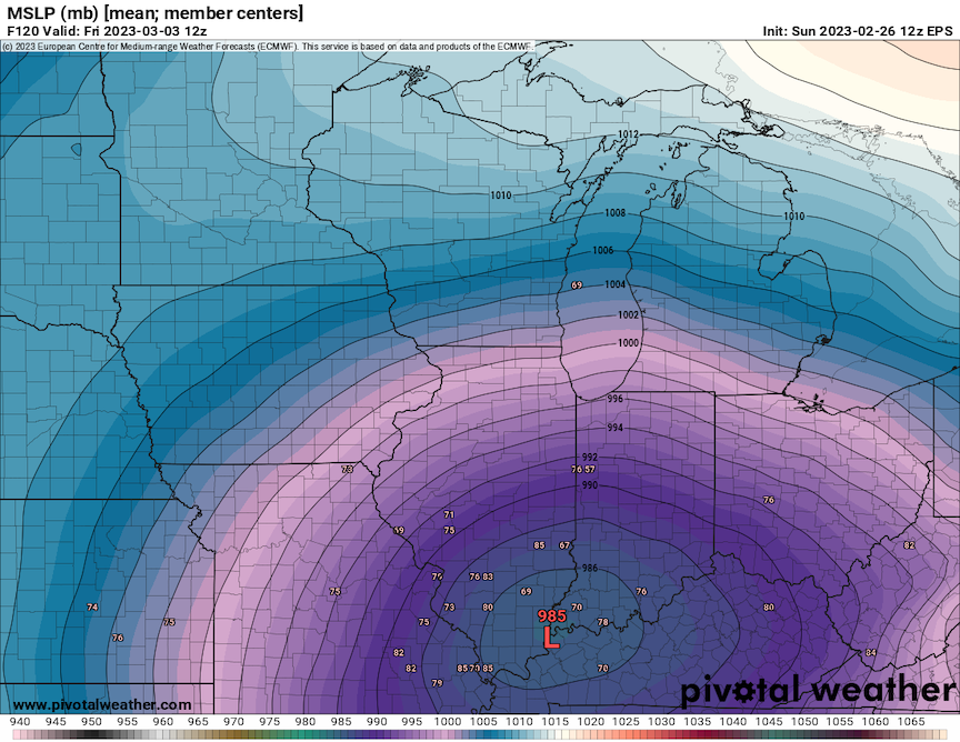
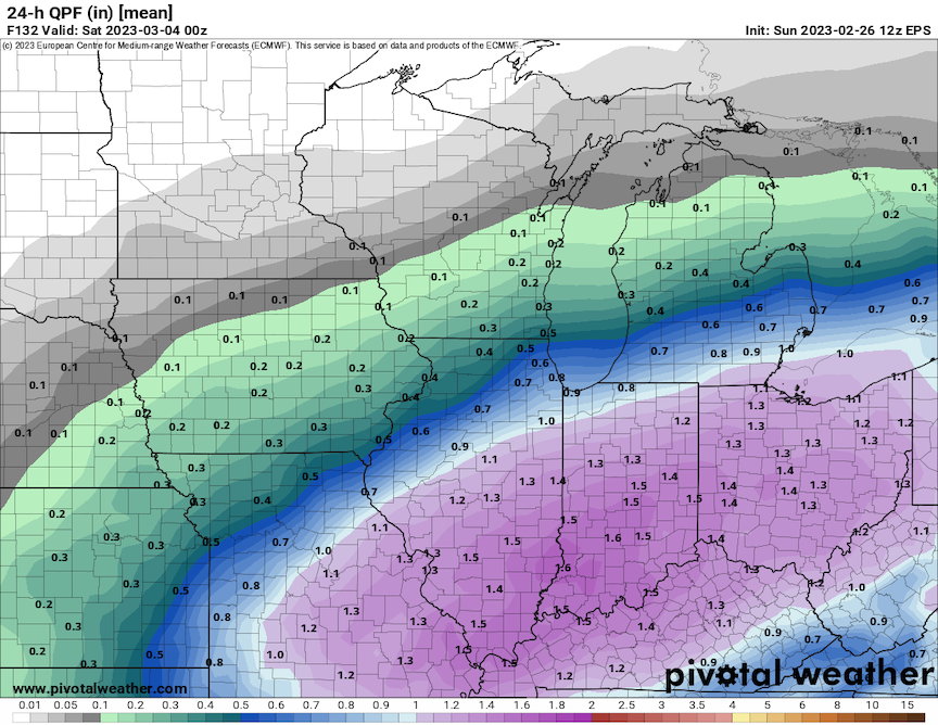
12z EPS north. Mean total QPF of 1.00" makes it close to IKK. Hmmm
Lots of sub 980 lows in there. The 957 just to the west of LAF though…
-
1
-
 1
1
-
-
Non-event for here. At least it won't be another rainer. GFS/GEFS versus the world. We know how that goes. Though, 6z EPS bumped north, but the same head fake happened with yesterdays 18z run too. Northern goal posts are probably a STL to IND on northeast line for something measurable, but smart money is further south. Looks good for the Ohio crew ultimately.
-
1
-
-
12 minutes ago, IWXwx said:
I got screwed on that too. The effective warm front is still about 30-40 miles south of me. Haven't been out of the mid 30's all day, while IND set a record high around 4 PM of 71°. Predicted high in the upper 50's. At least I got a t-storm out of it this morning.
Never had hope here. Unless you're like Hoosier and rode the 48 hour HRRR and RAP.
Tomorrow's quick torch looks like a non-event too. What a miserable system on the cold/wet side.
-
On 2/19/2023 at 10:20 AM, OrdIowPitMsp said:
Deal. We’ve got the all time seasonal snowfall record of 98.6” from 82-83 to break. Sitting at 55.6” with a good shot at being over 70” by the end of the week.
On 2/21/2023 at 12:43 PM, michsnowfreak said:Very interesting that 1982-83 is minneapolis' snowiest Winter. That was a bad snow Winter just South of there in the Midwest. Sort of a similar set up to this year
1983-84 is their #1. 1982-83 was good there (74.4"), but ranks #13.
Their top 10, BTW...
98.6" in 1983-84
95.0" in 1981-82
88.9" in 1950-51
86.6" in 2010-11
84.9" in 1916-17
84.1" in 1991-92
81.3" in 1961-62
79.0" in 1951-52
78.4" in 1966-67
78.3" in 2017-18
77.1" in 2018-19
-
1
-
-
2 minutes ago, Hoosier said:
It's torching just south of there in Crawfordsville. Tricky when you're near a large gradient.
True. But seems the models usually underplay temps when you're on (close to) the line. LAF went the other way. Bad beat for them.
-
Models pulled the rug on MSP. Hate to see it. Still a solid storm, but what might have been.
Also, models were awful with temps looking at LAF. They're at 39˚ currently. Most models had them in the 60's right now. 12z Euro had them in the low 60's all afternoon. Woof.
EDIT: zone forecast for today.
TIPPECANOE- INCLUDING THE CITIES OF LAFAYETTE AND WEST LAFAYETTE
328 AM EST WED FEB 22 2023
TODAY SHOWERS AND SCATTERED THUNDERSTORMS. NOT AS COOL WITH HIGHS AROUND 60. SOUTHEAST WINDS 10 TO 15 MPH WITH GUSTS UP TO 25 MPH, BECOMING SOUTHWEST 15 TO 20 MPH WITH GUSTS UP TO 40 MPH THIS AFTERNOON. CHANCE OF RAIN NEAR 100 PERCENT.
-
6z Euro nudged south a tad with the overall snowfall totals. Still, MSP sitting pretty close to the highest totals. Amazing consistency on the models.
-
Crappy winters don't get to me anymore. I've lived through enough of them to know they happen. Snow is and will always be my favorite though. I've seen some pretty awesome winters, and checked off a lot of my "bucket list" wants. Only thing left is a 2 footer. We'll see if it ever happens.
But having a job that works outside, the extremes are what I don't care for anymore. Super cold, super hot/humid, super windy, icy conditions...f*ck that noise. And rain...just pure hatred. Last Thursday's storm and this upcoming Wednesday with the cold soaking rain...the absolute worst. Outside of wishing for snow, I'm onboard for 75˚ and sunny most of the time. May need to move though.
-
6
-
1
-
-
17 minutes ago, Hoosier said:
RGEM came in fairly amped.
3 minutes ago, Natester said:Also a touch north.

-
Models have been remarkably locked in on MSP seeing an all-timer. Can't remember seeing such consistency on the models for several days. That sure doesn't happen in these parts, thats for sure, lol. Anyways, here's their top 5 snowstorm list. This one is a lock to be inside that list, as long as both parts are considered one system, which I assume it will.
1) 28.4" Oct 31-Nov 3, 1991
2) 21.1" Nov 29-Dec 1, 1985
3) 20.0" Jan 22-23, 1982
4) 17.4" Jan 20-21, 1982
5) 17.1" Dec 10-11, 2010
As well, here's their top 5 3-day total snowfall list:
1) 34.6" Jan 20-22, 1982
2) 27.8" Oct 31-Nov 2, 1991
3) 26.7" Oct 30-Nov 1, 1991
4) 21.7" Jan 22-24, 1982
5) 21.1" Nov 29-Dec 1, 1985
And finally, MSP sits at 55.6" for the season. This storm may put them close to 80" by the time it's done, if all really goes to plan. And with the pattern locked into them seeing several more snow events in the next 2 weeks, their season snowfall record is in serious jeopardy. They may "2007-08 MSN" their possibly former #1. List below...
1) 98.6" in 1983-84
2) 95.0" in 1981-82
3) 88.9" in 1950-51
4) 86.6" in 2010-11
5) 84.9" in 1916-17
-
2
-
-
4 minutes ago, Hoosier said:
Was that was the one when he said he got the 500 mb pattern right? As if people are gonna care about that.
yes.
-
45 minutes ago, Hoosier said:
I still remember complaining on WWBB about it.

Haha, yep. And then the epic JB winter forecast bust the next winter.
22 minutes ago, WestMichigan said:If I recall, there was a lot of complaints on WWBB that winter.
March 2001 storm. That was entertaining.
-
2 hours ago, Hoosier said:
It's almost like 2000-01, but without the spectacular December. Just a minor difference.
lol, yeah. Of course Jan and Feb 2001 didn't torch, the pattern just went dormant. And the only "real" 3 events during those two months were rainers.
-
14 minutes ago, RCNYILWX said:
The best that can be said is that the ensembles currently have an active non-torch look out towards mid month. But we know how that goes, plus it'll be mainly doldrums until then.
It's unfortunate that there wasn't a more widespread warning criteria snowfall event in this recent more active stretch. And that the short-wave for what might have been the semi-annual end of January to GHD period storm got buried in the southwest.
Yeah, earlier ensemble runs were hinting at the potential for our GHD event, but that went poof. Our luck has been sh*tty with these favorable periods. And they've been fleeting chances. Alas, thats how it goes sometimes. Especially in clunker winters. We'll see if we can pull a rabbit out the rest of the way...
-
Don't think February is gonna save us again, like the last couple of winters. 3rd year Ninas can be tough. Oh well, maybe we can find one decent event the rest of the way. Otherwise, here's to a better one for next winter.

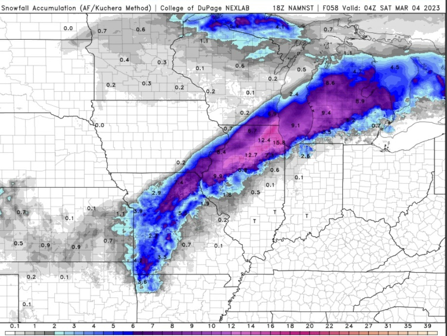
March 3-4 Potential Winter Storm
in Lakes/Ohio Valley
Posted
Preview of update after tonight's 0z NAM above.