

Chicago WX
-
Posts
18,395 -
Joined
Content Type
Profiles
Blogs
Forums
American Weather
Media Demo
Store
Gallery
Posts posted by Chicago WX
-
-
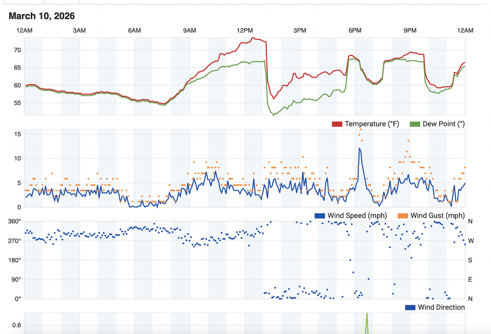
I've never seen anything like what I did today. Absolute genuine fear from people here of forecasted 2"+ hail. People wrapping their cars in anything and everything they could find. Blankets, cardboard, mattresses, etc. People scrambling to park their cars in hospital parking garages. Mind you we're 16 days from an insane amount of cars getting damaged from the hail storm of a lifetime, but the PTSD was very real. Thankfully, this was a non-event here today.
-
 1
1
-
-
These “squalls” this morning are legit. Sky gets dark as they roll through, and dump for 15 minutes at a time. Then it gets light. Rinse and repeat every 30 minutes.
-
Ripping right now. What a last week of weather. I need a break.
-
 1
1
-
-
1 minute ago, ILSNOW said:Image

Trash model. Been lost the whole time.
-
Caught a break with the high wind warning for here. LOT calling for 65 mph gusts, and we've only managed a few around 32 so far. You know, this area needs all the help we can get with the ongoing recovery.
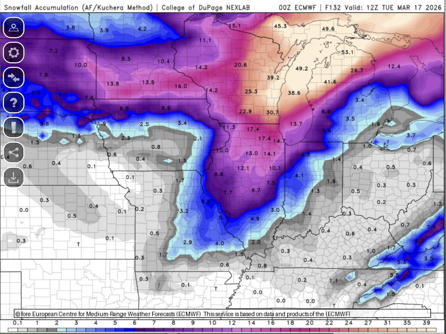
Going to be interesting to see happens with winter part in N IL. Hope to see an inch or two here, which looks like a decent possibility.
And this from the blizzard warning text for Green Bay. 2-4"/hour. Awesome.
* WHAT...Heavy snow and blizzard conditions expected. Snow, heavy at
  times with snowfall rates of 2 to 4 inches per hour. Additional
  accumulations between 9 and 13 inches with the lowest totals
  towards Oshkosh and Chilton. Winds gusting as high as 50 mph will
  result in considerable blowing and drifting snow and blizzard
  conditions into Monday. The Monday morning commute will be severely
  impacted.
-
33 minutes ago, cmillzz said:
Going to have a huge impact on the late week warm-up if this were to transpire unfortunately
To be honest, that's the least of my concerns. Massive clean up ongoing around here from the tornado. Tomorrows winds to 60 mph not going to help. But throw a foot of cement on top of it all, not ideal. Of course snow is my #1, so I'm rooting it on, but just trying to be real.
-
2
-
-
This would pretty much make this week one of the wildest of my "weather" life.


-
3
-
1
-
 1
1
-
 1
1
-
-
1 hour ago, nvck said:
I know some people doing research w/ lake-breeze fronts and their influence on CI, this could be really useful for a case study
If it can be useful, certainly pass it along.
These are the links to my weather station: https://www.wunderground.com/dashboard/pws/KILKANKA33/table/2020-10-21/2020-10-21/daily
https://ambientweather.net/dashboard/7bf27a3c338d927765d0080306d7c4a9
-
1
-
 1
1
-
-
15 minutes ago, King James said:
Regarding the lake breeze, again I’m about 2 miles north and 2 miles west of lake village
The lake breeze ripped through here and dropped it to about 52 degrees with stiff north winds
Around 4 o’clock the stiff lake breeze relented and we made it to about 58 degrees
By around 5 o’clock when I get back from picking up my wife we were at about 64 degrees and the neighbors flag was showing winds out of the E/SE.
After the tornado passed just south, and before the next rounds of storms, the humidity came back and it felt like a stormy night
But just before it hit, SE winds and it wasn’t very humid or juicy feeling out
Anyway, just sharing. I was glued to the weather and being outside yesterdayThis is the graph of my home weather station yesterday. You can see the lake breeze and then the recovery.
-
4
-
1
-
-
1 minute ago, IWXwx said:
I think someone already mentioned this, but your shingles are toast.
lol, yeah. Roofers gonna be making some big money around here. Alas, needed new gutters anyways.

-
Just now, A-L-E-K said:
def a blessing that this all time hail event happened before budding/leaf out
Absolutely. It knocked down a ton of branches though.
-
Hopefully these have loaded. Posted a few videos to my x account. First one is the hail. Make sure sound is on. Somehow that pool cover made out completely unscathed.

Second 2 videos are looking south where the tornado developed.
-
5
-
2
-
-
3 hours ago, KeenerWx said:
Still cellular, but slowly getting more information locally. Damage and videos show probably a few hundred yards to noticeable impact and probably less than half of a mile from considerable damage reported. Also replayed the video I took while coming out from shelter to check on the situation*. The tornado is very audibly noticeable. Boring video because it’s pitch black, but features constant roar of wind and a suction sound as the door to my patio shuts.
*I’m dumb for coming out of shelter to check. It was a chaotic environment featuring me, spouse, an elderly grandparent we are caretaking, 3 dogs & 3 cats. From the moment power cut, I lost ability to monitor radar. Not even cell data would work. The couplet was clearly headed for us, and I did my best to estimate it the time it would take to clear. I was too focused on alleviating the chaos with an all clear. Lessons learned. First time I felt genuine threat from a tornado. Nerves still fried and I generally love the spicy booms.
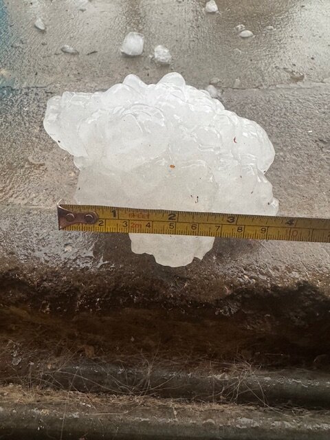
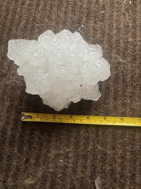
I feel you. Probably only the second time in my life I felt anxious during a storm (first was Nov 2013 in the LAF). Things happened so quickly here. Watching the radar and thought the core of the cell would miss me to the northwest. Then it developed and right turned. Told my gf to grab the dogs and shelter. Called my dad to tell him to get into the basement. Of course I go out in the back to see it unfolding. Could see (and hear) the rotation/tornado to my south, which I'm guessing was when it first dropped here. My viewpoint wasn't great being in the city, but I had enough to see things get going. Took some video, but it doesn't really show as much. But the hail..just incredible. I posted the photo of a 4" stone here, but there may have been bigger. But when softballs are falling from the sky, you can't be choosy.
-
3
-
-
1 minute ago, IWXwx said:
Wow. Glad you're safe dude.
Me and you both. I'll take a bad roof and gutters over that.
-
2
-
-
Violent as fuck. This is looking south on Schuyler Ave (45/52) on the far southside of IKK. This is legit 5 miles from my house. Would have been catastrophic if this moved a bit north through the city.
Friends of ours that live on Sandbar Road near Aroma Park say its not pretty. Lots of homes damaged.
-
2
-
-
18 minutes ago, A-L-E-K said:
Roofing contractors

And cars. I just drove around the 'hood. Tons of people tarping windshields, back windows, etc.
So far, only noticeable damage at my house is dented gutters..
-
1
-
-
I live on the Southside. Could see it and hear it passing to my south. Holy sh*t hail. This was the biggest, but lots of baseballs fell as well.
-
10
-
1
-
-
Just realized its been snowing for a little over 24 hours now. Shame 75% of it was sand, but winter vibes are nonetheless high. One of the LES bands making into Kankakee county now.
-
3
-
-
RAP also picked up on this regeneration/enhancement better than the HRRR. Its done a much better job overall with this system, between the 2 short range models.
-
3
-
-
1 minute ago, A-L-E-K said:
rrfs ftw? Was a difficult setup for models to resolve locally
It certainly wasn't the GFS
-
2
-
2
-
-
28 minutes ago, Chicago916 said:
Whiteout conditions! Heaviest all winter with fluffy dendrites. Hoping the primary low hangs on longer to keep the NE flow going later. Also looks like the upper trough is aiding in redeveloping snow to the southwest.
11 minutes ago, RCNYILWX said:Looks like we're getting another surge of large scale forcing to hook up with the lake enhancement. Banding filling back in from the southwest. We'll see if the LES multi bands intensify even a bit more as this occurs.
Sent from my SM-S936U using Tapatalk
Yeah, surge is here. Big flakes. Really, best snow rates of the entire event. Took me by surprise.
-
3
-
-
Measured 3.2" a little while ago. Best rates have been this morning. Overall, ratios have been blah, but I think we kinda knew you had to get into good bands to get the fluff. LOT's call of 3-5" was money. Over 30" for the season now IMBY. Looks like winter again. I'm pleased.
")
-
3
-
-
24 minutes ago, RCNYILWX said:
More recent radar frames suggest flake size may be soon or already is improving some up to roughly I-88 in the metro.
Sent from my SM-S936U using Tapatalk
Definitely has here as better returns have moved into IKK. It's not parachutes, but actual snowflakes versus sand.
-
1
-
-
8 minutes ago, A-L-E-K said:
I-L-L
I-N-I
!!!
Sand accumulating as best as it can do here.
-
1
-

Severe Threat 3/26/2026
in Lakes/Ohio Valley
Posted
Very true. The forecast from LOT and SPC was hitting the large to very large hail wording pretty hard. Plus the tornado threat. Knowing what I know, knew that was a long shot. The lake breeze moved through here earlier than expected, and kept going chugging south, unlike 3/10. But the mailman isn't the weatherman.
It was interesting to me how that message was a definitely out there, loud and clear. Normally, I believe people kinda shrug off severe potential days, but with what that this city went through two weeks ago, the forecast was certainly well received. But, two to three months from now, same messaging threat, people probably go back to being "meh" about it. Which I get it really...