

Chicago WX
-
Posts
18,285 -
Joined
Content Type
Profiles
Blogs
Forums
American Weather
Media Demo
Store
Gallery
Posts posted by Chicago WX
-
-
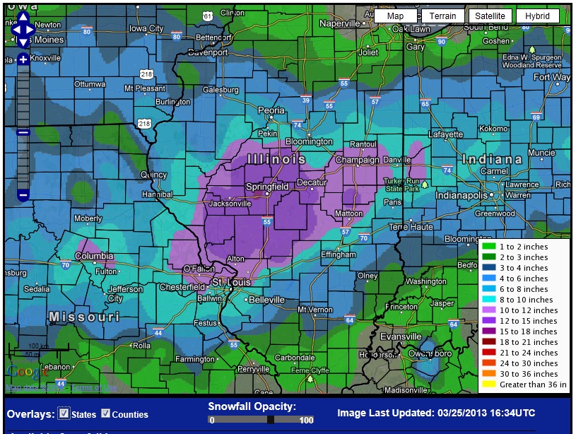
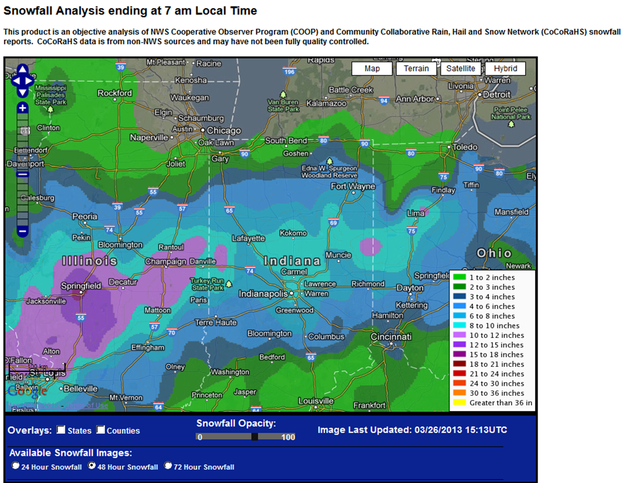
Didn't really think about it until now, but today (and yesterday) is the 10 year anniversary of this beauty. Springfield IL broke their all-time record biggest snowfall with 18.5". Had close to a foot in the LAF. A couple of not 100% accurate maps below.

-
 1
1
-
-
1221 PM     SNOW             2 N MENASHA             44.23N 88.44W
03/25/2023  E20.0 INCH       WINNEBAGO          WI   PUBLIC

            ALMOST 20 INCHES.
1202 PM SNOW E NEENAH 44.18N 88.44W 03/25/2023 M17.5 INCH WINNEBAGO WI TRAINED SPOTTER SNOW AMOUNT SO FAR. LOCATED ON THE EAST SIDE OF THE CITY ABOUT FOUR BLOCKS FROM LAKE WINNEBAGO.-
1
-
-
Appleton zone forecast from this morning. To be fair, they were under a WWA at that point for 3-6", but doesn't show up explicitly in the zone text. Regardless, that area has seen 12"+ so far, and it's still S+ there right now. Would love to see a positive bust like that for once.

INCLUDING THE CITY OF APPLETON 245 AM CDT SAT MAR 25 2023 ...WINTER WEATHER ADVISORY IN EFFECT UNTIL 4 PM CDT THIS AFTERNOON...
EARLY THIS MORNING MOSTLY CLOUDY WITH A CHANCE OF SNOW SHOWERS. TEMPERATURES NEAR 30. NORTHEAST WIND 10 TO 15 MPH.
TODAY CLOUDY WITH A CHANCE OF SNOW SHOWERS. HIGHS IN THE UPPER 30S. NORTH WIND 10 TO 15 MPH. CHANCE OF SNOW 50 PERCENT.
TONIGHT MOSTLY CLOUDY IN THE EVENING THEN BECOMING MOSTLY CLEAR. LOWS IN THE MIDDLE 20S. WEST WIND 10 TO 15 MPH.
-
1
-
-
MKE FTW

KMKE 251152Z COR 03013G22KT 1/2SM R01L/3000V5500FT SN FG VV004 01/00 A2944 RMK AO2 SLP976 SNINCR 3/5 4/005 P0027 60049 70049 T00060000 10033 20006 55026
-
Big shift south on the 12z NAM, with respect to N IL snow prospects...farther south snow field. IA, WI, and MI jackpot, as usual. Probably overdone with amounts, but fun to look at I guess.
-
Just got home and measured 3.5" of concrete. Pretty good for essentially 5 hours of snow. The flake size, winds (though not as crazy as south and east of here), and of course TSSN made it a pretty fun event. Obviously wish it would've lasted much longer, but beggars can't be choosers.
-
5
-
-
22 minutes ago, King James said:
Legit some of the biggest flakes I’ve ever seen
7 minutes ago, King James said:Big old rumbles of thunder
This is great. Won’t get true big dog totals, but this event will help me raise my winter grade from a F to a D-

Big gust of wind just rolled through here.
-
2
-
-
TSSN! Fucking awesome!
-
10
-
 1
1
-
-
Holy shit right now. S++ right now. Giant flakes. This is awesome! Just need a little TSSN
-
8
-
-
Just now, vortex said:
Good luck.
Finally changing over to snow here in the west end of the county.Wow. Nice micro climate we got today.
-
23 minutes ago, King James said:
Starting to stick to the grass. Coming down pretty good
Rip city with big wet aggies. Roads and sidewalks are starting to cave. Kinda surprised…
EDIT: I see IKK is down to 33.
-
2
-
-
All snow here now. Big wet flakes. Wind gusts getting much more frequent. What a day to work outside.
-
4
-
-
Getting some cat paws mixing in here. Winds have definitely picked up from the north.
-
1
-
-
59 minutes ago, RCNYILWX said:
Temps and dew points are solid above the colder guidance. Looking problematic for any accums in our IL counties and even NW IN will probably underperform unless it absolutely rips this afternoon following changeover.
Strengthening east northeast flow may help bring in slightly lower dew points and help there, but especially IWX CWA. Up here in the metro, there's forecast to be strong lift in the DGZ, though strong subsidence and some drying in the lower levels northwest of the f-gen banding, per forecast soundings.
Sent from my SM-G998U using Tapatalk
Just pouring rain here and temps are torching. Just can’t see any mode to make it snow here. Unfortunately, I see the HRRR is increasing rainfall totals for here. Going to make a bad flooding situation even worse. Bad times.
But thanks to you and OHweather for giving us your thoughts. It’s much appreciated.
")
-
6z Euro went east too. Waving the white flag on this one. Good luck to the peeps in Indiana and Michigan. Hope it over performs.
-
 1
1
-
-
25 minutes ago, King James said:
Still don’t know what the expect here in IKK. Within the last couple hours LOT cut the totals back for me and WGN (my dude skillling) bumped the totals up for me. 2-12 inches I guess
Yeah, no idea. 0z models looked really good, but everything at 6z went east. HRRR and RAP are bleeding east with every run. Kinda stupid this close in. Has shades of Feb 2016, but shittier thermals. Think my final call is 0-6". We'll hope for the best of course.
-
1
-
-
LOT just pulled the trigger on a Warning for here. 4-8” with locally higher, and gusts in excess of 45 mph. The 2-3” per hour and thunder snow parts would be pretty sexy.
838 PM CST Thu Mar 2 2023
...WINTER STORM WARNING IN EFFECT FROM NOON TO 10 PM CST FRIDAY...
* WHAT, Heavy wet snow accumulations, intense snow rates, strong
northeast winds, low visibility, and dangerous travel conditions
expected. Total snow accumulations of 4 to 8 inches expected
with locally higher amounts. In addition, northeast winds will
gust in excess of 45 mph.
* WHERE, Portions of east central and northeast Illinois and
northwest Indiana.
* WHEN, From noon to 10 PM CST Friday.
* IMPACTS, Travel will become difficult and dangerous, including
during the Friday afternoon and evening commute. The
combination of heavy, wet snow accumulations on trees and strong
northeasterly winds may lead to downed tree limbs and localized
power outages.
* ADDITIONAL DETAILS, Snow rates of 2 to 3 inches per hour and
thundersnow may occur within a narrow but intense band of snow.
This will cripple travel conditions including during the
afternoon and evening commute.-
2
-
-
Just now, Harry said:
It can depend. Jan 67 is best example of sharing in the glory. Jan 78 was more here. GHDI was more there to Grand Rapids. GHDII was a bit more here.
Jan 1979?
-
1
-
-
1 minute ago, frostfern said:
Miss south stank?
-
3km is ridiculous. Looping the 1-hour 10:1 snow maps, it has 3.9” here for one frame. I mean I’d love to see it, but not planning to move to a LES belt yet.
-
1
-
-
14 minutes ago, A-L-E-K said:
lol
Take it to the bank
-
20 minutes ago, Baum said:
memories of a march storm in the 1990's comes to mind. Call was for 1-2" on grassy areas. By mid day parachutes were falling with thunder and got about 6-8" in several hours. One of my favorite busts. Has all the earmarks.
10 minutes ago, King James said:March 8th 1998? One of my favorite storms of all time. Went to bed with no snow, woke up with cement plastered everywhere. Was quite a sight and a lot of fun to play in
Yeah. March 1998. Lightning and thunder and all of it with that storm. You can read the AFD and forecast on the Iowa State site from that storm. Positive bust indeed.
-
2
-
 1
1
-
-
5 minutes ago, RCNYILWX said:
Just sent an AFD update. Basically, it's hard to say we'll be 80% confident in warning snow amounts/impacts anywhere in the CWA. Assuming the NAMs are too far NW, general idea is southeast of I-55, *if* the banding is intense enough for dynamic cooling to overcome the marginal BL. Throw convection into the mix and the fact that we're basically trying to precisely place a mesoscale feature (response to f-gen circulation) and say we're confident the dynamic cooling will be enough, it's a tough call.
Even with the GFS, we're talking pretty high end impacts for the populous south suburbs, Kankakee county, and NW Indiana corridor. But the Canadians (not that they're great models) have me concerned and getting vibes of the Christmas Eve 2014 bust. If the GFS is right, that's a similar look to what happened on 2/24/16. And again, there's error bars on the exact placement of banding northwest of the compact vertically stacked low.
Sent from my SM-G998U using Tapatalk
Good luck. We’re all counting on you.
Still no idea what to expect here. Truly.
-
6 minutes ago, michsnowfreak said:
The last few winters have been fine. Only this Winter has been crap. I would not call the winters of 2020-21 and 2021-22 ones with few meager opportunities. Hell, snow depths in February 2021 were 15" in Detroit, 18" in Toledo, and 21" in Chicago.
Feb 14-16, 2021 had the storm start off snowing with temps below zero. Marginal my ass. But recency bias always prevails around here.
-
1
-
1
-
March 31st Severe Threat
in Lakes/Ohio Valley
Posted
Pea to marble sized hail here. Lasted about a minute. Quick mover and not much lightning/thunder with it.