Chicago WX
-
Posts
18,395 -
Joined
About Chicago WX

Recent Profile Visitors
8,889 profile views


-
Very true. The forecast from LOT and SPC was hitting the large to very large hail wording pretty hard. Plus the tornado threat. Knowing what I know, knew that was a long shot. The lake breeze moved through here earlier than expected, and kept going chugging south, unlike 3/10. But the mailman isn't the weatherman. It was interesting to me how that message was a definitely out there, loud and clear. Normally, I believe people kinda shrug off severe potential days, but with what that this city went through two weeks ago, the forecast was certainly well received. But, two to three months from now, same messaging threat, people probably go back to being "meh" about it. Which I get it really...
-
I've never seen anything like what I did today. Absolute genuine fear from people here of forecasted 2"+ hail. People wrapping their cars in anything and everything they could find. Blankets, cardboard, mattresses, etc. People scrambling to park their cars in hospital parking garages. Mind you we're 16 days from an insane amount of cars getting damaged from the hail storm of a lifetime, but the PTSD was very real. Thankfully, this was a non-event here today.
-
These “squalls” this morning are legit. Sky gets dark as they roll through, and dump for 15 minutes at a time. Then it gets light. Rinse and repeat every 30 minutes.
-
Ripping right now. What a last week of weather. I need a break.
-
Trash model. Been lost the whole time.
-
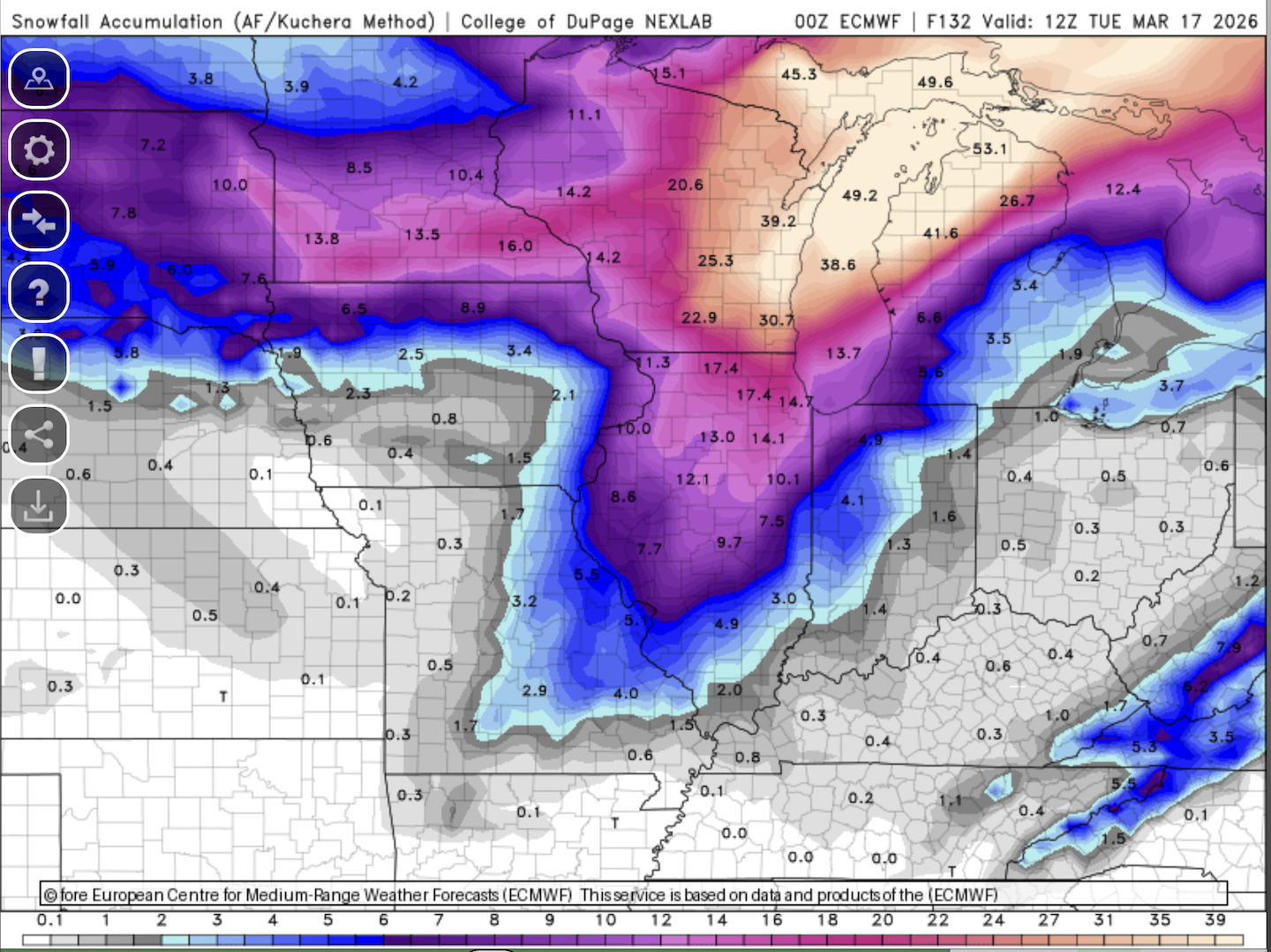
Caught a break with the high wind warning for here. LOT calling for 65 mph gusts, and we've only managed a few around 32 so far. You know, this area needs all the help we can get with the ongoing recovery. Going to be interesting to see happens with winter part in N IL. Hope to see an inch or two here, which looks like a decent possibility. And this from the blizzard warning text for Green Bay. 2-4"/hour. Awesome. * WHAT...Heavy snow and blizzard conditions expected. Snow, heavy at times with snowfall rates of 2 to 4 inches per hour. Additional accumulations between 9 and 13 inches with the lowest totals towards Oshkosh and Chilton. Winds gusting as high as 50 mph will result in considerable blowing and drifting snow and blizzard conditions into Monday. The Monday morning commute will be severely impacted.
-
To be honest, that's the least of my concerns. Massive clean up ongoing around here from the tornado. Tomorrows winds to 60 mph not going to help. But throw a foot of cement on top of it all, not ideal. Of course snow is my #1, so I'm rooting it on, but just trying to be real.
-
This would pretty much make this week one of the wildest of my "weather" life.


-
If it can be useful, certainly pass it along. These are the links to my weather station: https://www.wunderground.com/dashboard/pws/KILKANKA33/table/2020-10-21/2020-10-21/daily https://ambientweather.net/dashboard/7bf27a3c338d927765d0080306d7c4a9
-
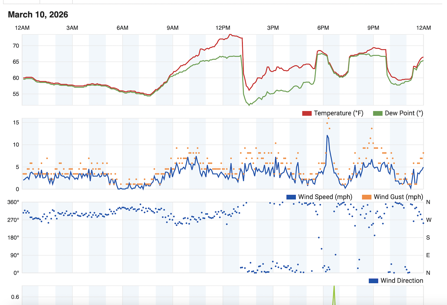
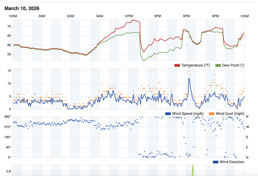
This is the graph of my home weather station yesterday. You can see the lake breeze and then the recovery.
-
lol, yeah. Roofers gonna be making some big money around here. Alas, needed new gutters anyways.
-
Absolutely. It knocked down a ton of branches though.
-
Hopefully these have loaded. Posted a few videos to my x account. First one is the hail. Make sure sound is on. Somehow that pool cover made out completely unscathed. Second 2 videos are looking south where the tornado developed. https://x.com/PostalWeather/status/2031699162455060554 https://x.com/PostalWeather/status/2031700079694712924
-
I feel you. Probably only the second time in my life I felt anxious during a storm (first was Nov 2013 in the LAF). Things happened so quickly here. Watching the radar and thought the core of the cell would miss me to the northwest. Then it developed and right turned. Told my gf to grab the dogs and shelter. Called my dad to tell him to get into the basement. Of course I go out in the back to see it unfolding. Could see (and hear) the rotation/tornado to my south, which I'm guessing was when it first dropped here. My viewpoint wasn't great being in the city, but I had enough to see things get going. Took some video, but it doesn't really show as much. But the hail..just incredible. I posted the photo of a 4" stone here, but there may have been bigger. But when softballs are falling from the sky, you can't be choosy.
-
Me and you both. I'll take a bad roof and gutters over that.