

Snowstorms
-
Posts
3,925 -
Joined
Content Type
Profiles
Blogs
Forums
American Weather
Media Demo
Store
Gallery
Posts posted by Snowstorms
-
-
24 minutes ago, Ottawa Blizzard said:
I hope we at least get 4-6" (10-15 cm). I'm in Scarborough, bordering Markham, so I might have a better chance.
18z NAM shifts further SE leaving Toronto closer to 5cm or less. Too many moving pieces right now.
-
9 minutes ago, Ottawa Blizzard said:
I definitely can! I was in Grade 7. One of the biggest snowstorms of my life. Initially they had been calling for 15cm (6") and we ended up getting close to 40 cm (17")! Some friends of ours were part of the cast of Joseph and his Technicolour Dreamcoat, and they got stranded downtown after the performance and had to be put up in a hotel.
That's awesome. I will have to check that film out then.
This storm was powerful Nor'easter. It's not talked about enough but this storm is definitely a top 10. Ironically a few months later the March 1993 storm happened but was a bit too far east for us. I don't know where I can find a radar reanalysis of this storm but would be pretty cool to see.
-
4 minutes ago, Ottawa Blizzard said:
This kind of reminds of the January 16-17, 1994 storm. That storm gave about 8", or 20 cm, to Toronto. It was preceded by extremely cold weather on the 15th and 16th.
I was born a couple months later to remember it
 . This storm at the surface level is similar to the Dec 10-11, 1992 storm. That storm packed a punch for us. Most places in Toronto saw 15-20" (38-50cm) with some close to 2 feet. I'm not sure if you can remember that?
-
@blizzardof96 Any preliminary thoughts on this storm for us?
Subtle differences in the track could mean the difference between 5-10cm vs 15-20+cm. The 12z GFS trended west vs 00z GFS to be more aligned with RGEM. You can also put NAM in that bucket too. The RGEM at 54hrs is more pronounced with the main energy and digs the energy across the midwest more than the NAM. This plays a key role later on and the difference becomes more apparent at 66hrs. Still a lot to iron out. One thing that could really amp up totals for Toronto is where the defo band sets up. I remember it well during the Feb 13 storm. Many places saw 30+cm (12").
Not super confident yet. I think models could still flop flop through 00Z tom.
-
YYZ got down to -6F but felt closer to -26F with the wind. Coldest temperature since 2019 lol. Not a fan of extreme cold with no snow on the ground though.
-
11 minutes ago, Up_north_MI said:
Since 2000, the past 22 years, Detroit has had 1 top 20 coldest December and 7 top 20 warmest Decembers, I’m no climatologist but I sense a pattern going on here.
I'm guessing that 1 was Dec 2000 too lol. Only one that came close enough since was Dec 2017.
Decembers are typically cold in Nina's too.
-
The 2" we had the other day pretty much melted away today lol. Ready for the cold dry air. Arctic air + barren ground = best combo.
-
Our snow will likely melt with the two warmups and then we will all be cold and dry next 2 weeks in the "heart" of winter. How fun
-
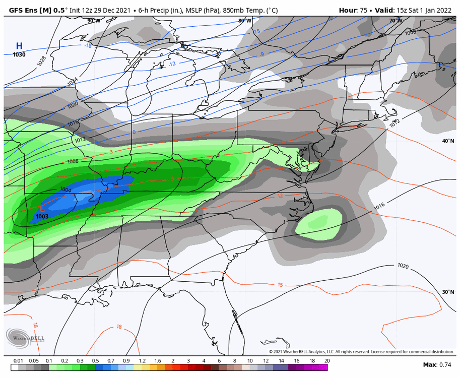
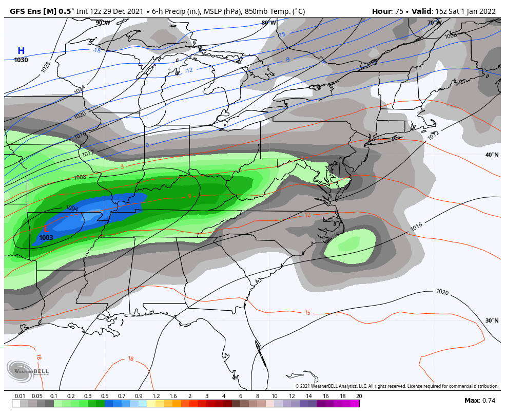
2 hours ago, blizzardof96 said:
Here's the spread in model snowfall output for YYZ. The variation is pretty ridiculous given the fact that snow is expected to start falling in just over 30hrs from now. I agree, I think 5-10cm is reasonable for the GTA. Some communities across S ON may see 10-15cm but too early to know where/if that might set up. I'm not convinced that we see a whiff south like the ECM/RDPS are showing -- they may be overcorrecting.

The trend seems to be weaker and further south right now. A large portion of the energy gets wrapped up further south into a potential secondary low. We'll see what tonights runs yield. I agree with the bold, it is ridiculous. Any reason why you feel we are seeing such high volatility among the models?
5-10cm does seem like a good bet for now. At the very least it should bring us closer to 50cm (20") for the season.
Edit: Must be tough for meteorologists like yourself to issue a proper forecast right now.
-
@blizzardof96 Not feeling confident yet on snowfall amounts across the GTA. RDPS is south and weak, NAM 3km is north while the GFS/HRRR are nudged in between. The difference is more notable on the vort maps and the trough orientation and dig. At least we can be certain it'll most likely end up as snow lol.
I think 5-10cm as of now would be a reasonable call.
-
4 hours ago, blizzardof96 said:
Yep, the rain/snow transition time will be key. That will be dictated by the track of the surface low. A spatial mean of the 12z GFS/GDPS/RDPS/UKMET/6z ECMWF supports a general 5-10cm south of the 401 and 10-15cm north of the 401. Will see if that holds and whether model consensus starts to build over the next 24-36hrs. I think your forecast is a pretty good starting point with some room to increase if consensus builds.
I agree. 18z runs were much cooler and much snowier for us (10-15cm). Let's hope that holds serve for 00z tonight. Nice overrunning event. The blocking doing a number on keeping this storm from amping up more but it'll do. I'd assume models are playing catch up with those cold NNE winds? Thermals should cool pretty quick so I'd imagine snow ratios would become better and better as the precip continues to fall.
-
@blizzardof96 Latest RDPS is cooler than 06z for the GTA. However, 850's and sfc temperatures are quite marginal. I agree it will start as rain though but how quickly it transitions over is the real question. Those cold NNE winds can be underestimated by models sometimes so perhaps we could cool down rapidly. Might be a long light snow event after the initial thump moves through.
Still not overly optimistic yet. But I'm thinking 4" away from the Lake and <5cm (2") near the Lake.
-
 1
1
-
-
Just now, blizzardof96 said:
Looks solid indeed. Hopefully the signal holds.
Looks decent for our area too. Might start as rain but could transition over rapidly.
-
1
-
-
1.6" today at YYZ putting us at 16.5" for the season now.
-
2
-
-
20 hours ago, ILSNOW said:
Watching the bears play Seattle in the snow when we have had none is unbelievable
It was 6F this morning in Vancouver. Crazy cold.
-
1
-
-
YYZ reporting SN with visibility down to 0.5 miles. Not much accumulation, maybe an inch?
-
2 hours ago, snowman19 said:
Assuming we don’t see a major SSW, it will be interesting to see what happens come mid-late January, that’s the time La Nina’s typically start to bring mild conditions, especially February, as the tropical forcing moves back to the maritime continent. This La Niña is obviously very strongly coupled, along with the -PDO, and if it follows climo that’s what we SHOULD see, however, given AGW, I wonder if something weird happens…..
I think some Nina's are backloaded like 1949-50 or 1971-72 just to name a few. Hopefully that's the case this year.
-
On 12/24/2021 at 11:35 AM, LibertyBell said:
It's amazing how quickly a/c usage drops from Portland to Seattle to Vancouver, but they never ever get this kind of heat so it's understandable. I never thought any place in Canada was capable of hitting 120, in the US it's confined to only the hottest part of the country. I heard a town was burned from all the fires (Lytton?)
Merry Christmas
I didn't think so either especially in B.C. too. The warmest we ever got in Toronto was 104F and that was in 1936 too. Yeah it burned all down, a lot of bigger towns like Kamloops were evacuated too. They get crazy fires every year like California. I think Seattle and Vancouver have similar climo's.
Look at Vancouver's forecast this week. 4"+ today. Can't believe it's more winter like there than here.
-
 1
1
-
-
5 hours ago, LibertyBell said:
everyone needs to have a/c by now. It should actually be illegal for everyone not to have a/c
A lot of residential places in B.C. don't have a/c. Summer temps usually hover in the 70's and low 80's. So I can only imagine what 120 would've been like. My family said the air was choking because of all the wildfires. It was dry heat tho but if it happened here we would've been done.
-
 1
1
-
-
Picked up 2.3" last night.
-
1
-
-
3 hours ago, A-L-E-K said:
lol

lmao went there last month, it was bone dry. They could use it.
-
2
-
-
That dual block (NPac Ridge + Greenland block) is shredding any system that tries to form and cut into our region. Not to forget that impressive Nina ridge in the south. Bummer. Pacific pattern is relentless, I don't see any major changes until at least January 10.
-
1
-
-
17 hours ago, michsnowfreak said:
Just a random tidbit to the Chicago snowless. The record for latest 1st measurable snowfall at Detroit is actually December 29, 1998. (I had 2 small 0.1" dustings in mid December, but DTW only had a trace). It broke the previous 1948 record by 10 days. Four days later...
That's impressive. But January 1999 made up for that nicely I'm assuming.
-
1
-
-
2 hours ago, snowstormcanuck said:
lol, I know right? We grind like champs here.
Except for the big dog on January 28-29, 2019, Toronto has not had an 8"+ snowstorm since the 2014-15 winter. By contrast, we've had 17 snowfalls in the 4-8" range in that same period.
The Nov 2020 storm was ~8" give or take. And the Jan 2020 storm came close too. But otherwise, I agree. Our climo just doesn't support big dogs. But I'm glad we crossed 100cm again.
Winter 2021-22 Complaint/Banter Thread
in Lakes/Ohio Valley
Posted
I feel winters in our region took a different path after the Super Nino in 2015-16. Think about it.
2014-14 was the last widespread cold and snowy winter. Since then we've barely managed to get a decent winter. 2015-16 and 2016-17 were warm. 17-18 had that mid-late Dec - early Jan and 2 week Feb period of winter. 2018-19 lasted 6 weeks (mid-Jan to late Feb) and then the last two including this winter have been crap.
Prior to 2015-16 we had longer lasting winters with more phased storm potentials. For example, 2013-14, 2012-13, 2010-11, 2009-10, 2007-08 etc. Just a personal opinion.