

Snowstorms
-
Posts
3,925 -
Joined
Content Type
Profiles
Blogs
Forums
American Weather
Media Demo
Store
Gallery
Posts posted by Snowstorms
-
-
45 minutes ago, blizzardof96 said:
12z Canadian Ensemble Mean remains east of RGEM and GEM-GLB low tracks

Very interesting set-up. The operational NAM was further west, like the RGEM, but the high-resolution NAM was much cooler at the surface. Which suggests stronger dynamic cooling as the initial low parks up over Hudson Bay keeping the WAA at bay. We’re riding an extremely tight gradient here. Depending where that gradient sets up, someone from Windsor to Toronto will have a brief but very intense burst of heavy snow with a fast-moving deformation band. The CMC digs the low more than the 3KM NAM and that pushes the secondary Low further west. You remained optimistic about this set-up from the start so let's hope that optimism pays off.
-
 1
1
-
-
8 hours ago, michsnowfreak said:
February is where it is at. Our average since 2000 has been 14.7" and since 2010 has been 18.0". Despite the pattern of the past few years there is no question that increasing snowfall in January and February, especially February, is what has been responsible for the 2010s being our snowiest decade on record. Lean snow years from the 1930s-60s really brought the avg down.
2010s vs 20th century
Nov- 2.9 vs 2.8
Dec- 8.5 vs 8.6
Jan- 14.3 vs 10.4
Feb- 18.3 vs 9.0
Mar- 5.0 vs 6.7
Apr- 0.9 vs 1.5
ssn- 49.9 vs 39.1
Is Toronto above avg to date?
18"? Wow. Our Feb average over the last 10 years is 16.7". Your seasonal average over the last 10 years has definitely surpassed Toronto's average. Been much snowier in SEMI of late compared to surrounding regions.
There's some missing data at YYZ this month so I can't tell you the actual figure but I am certain its ~17" which puts us above average to date. We've officially surpassed 2011-12 LOL. Only 4" short of our seasonal avg for December. A few other stations across the city are above 20" already. Close to 20" imby too. How is Detroit?
-
35 minutes ago, cyclone77 said:
DVN issued a wind advisory for parts of their northern cwa, but they need to include much more of their area. Getting gusts over 40mph already here, and the windiest time frame is still a ways away.
It’s sad when strong winds are the only exciting thing to talk about in December.
-
10 minutes ago, michsnowfreak said:
We had great December's in 16 and 17 But the 2 decembers on each side of it were terrible. This December at least we've had snow here but its not been the best. We are in a very odd pattern lately of early and late season cold and snow, with one of the Winter months being not so wintry. It's frustrating. But also snowlovers in much of the midwest were very spoiled 2007-2015. Thats why they say karma is a bitch. Its very cool to see these out of season snowfalls but id gladly give them up if we could get back on track lol. We had a March storm in 2017 and 2018, and of course March 15 had deep snow. So id say over the past decade Dec has been the least wintry month of DJFM. Going a step farther, and this requires subjective thinking, id say that relative to normal, from NDJFMA December has been the worst. Obviously Dec has been colder and snowier at face value that November and April, im talking relative to normal.
Solid points. December 2016 wasn't really all that cold tbh. Only December 2013 and 2017 were well rounded Decembers of late. I love a good November snowstorm but to take that followed by a snowless December? Nah. November snow and cold barely last more than a few days and the excitement of it dies out quick. We did get spoiled yes, but this stretch we are going through right now is equally comparable. February has been exceptional over the past 20 years locally. Our February average since 2000 is close to 14" lol. But similarly, other months especially Dec, Jan and Mar have taken a big hit. We got shit in March 2017 and 2018 so lucky you. March 2014 was our last above average month and before that March 2011. Tired of these half ass winters we keep getting.
-
17 minutes ago, michsnowfreak said:
I know it has been a frustrating start in Chicago and I like that you looked it both views. There are plenty of examples where there was good Winter after the New Year despite hardly any before the New Year. Today is only the 1st official day of Winter.
I think what's most frustrating is losing December again. 3rd warm December in a row and our 7th since 2010. That's just straight up ridiculous. Would be nice to get some good snowy cold Decembers again and not have to continually rely on January or February for snow. It's been years since we've seen a nice widespread March snowstorm as well. Seems like winters are continually being condensed into 2 months and it's becoming really frustrating. Losing December as a snow lover hurts, it's the worst.
-
2
-
-
1 hour ago, Chambana said:
1/3 of winter already ruined and wasted. Don’t worry folks, March and April will have our back. A common theme the last few years, unfortunately.
I haven't seen a good March snowstorm since 2014. Just dry cold without any decent warmth. Terrible.
-
9 hours ago, on_wx said:
Very March-esque today. Canada banned flights from the UK, and an Ontario-wide lockdown was leaked to start on Christmas Eve. The official announcement will be made at 1pm. Tension.
I hope it's not some half ass lockdown. This Toronto and Peel lockdown hasn't done anything to reduce case numbers. It's either you go all in or you don't at all.
Hopefully we start seeing vaccinations ramp up. My girlfriends’ brother is a doctor in Virginia and recently got both vaccine doses. He's doing great and if there are any side effects with these vaccines, they would likely occur within 48 hours should anyone get them. I'm tired of this and just want to move forward.
-
1
-
-
You're right. It was a boring year. Only a few things come to my mind.
- January rainstorm. (3" of rain. Has never happened before).
- Rare May snow and cold (1.2" locally). Snowiest May ever
- July heatwave. Widespread 90's across the sub
- November record breaking "heatwave" (as mentioned)
- November snowstorm (8-10" locally). 3rd biggest November snowstorm ever
-
36 minutes ago, Malacka11 said:
Can't wait for the GFS to cave in a day or two
Gonna be a rainer. A Grinchmas storm.
-
 1
1
-
-
51 minutes ago, mississaugasnow said:
Did you get much last night? Though sucks to miss the main storm, woke up to 1.5" of powdery snow. With the snow cover -5C and grey overcast skies its my perfect winter morning. Unlike all the other storms this year, this one actually has a winter feel to it. The other ones felt more spring like with temperatures rising back to above 0C once the snow stopped.
Got like 2.2cm (0.9") so you beat me this time.

I agree. There was a nice winter feel this morning, but it'll be back above freezing by this weekend. We need a nice widespread storm like Feb 2013. Tired of all the disappointing Decembers we've been experiencing.
-
1
-
-
2 minutes ago, BuffaloWeather said:
A poster from Upstate has a 44-45" snow depth, he likely got 50". Just insanity. It blew Binghamtons all timer snowstorm by like a foot.
That’s crazy. The only storm that comes to my mind that is comparable in amounts is probably the Blizzard of 93. And that storm was 2-3x the size of this one. Give me a storm like this in Jan or Feb. Thanks!
-
1
-
-
10 minutes ago, BuffaloWeather said:
Just crazy totals in central NY. Look at these 3 hours. I didn't know this was possible in NY from synoptic.

https://forecast.weather.gov/product.php?site=NWS&product=PNS&issuedby=BGM
...New York...

...Broome County...
2 SW Nws Binghamton          41.0 in   0640 AM 12/17   NWS Employee
Vestal                       41.0 in   0730 AM 12/17   Public
2 S Binghamton               41.0 in   0800 AM 12/17   Public
Endicott                     40.5 in   0550 AM 12/17   Trained Spotter
2 E Vestal                   40.2 in   0700 AM 12/17   NWS Employee
2 SW Vestal Center           40.0 in   0730 AM 12/17   NWS Employee
Nws Binghamton               39.6 in   0700 AM 12/17   Official NWS Obs
West Corners                 39.5 in   0649 AM 12/17   Public
Endwell                      37.0 in   0622 AM 12/17   Public
Chenango Bridge              36.0 in   0742 AM 12/17   Public
2 SSE Vestal Center          35.0 in   0747 AM 12/17   Public
Binghamton                   30.5 in   0715 AM 12/17   Public
Lisle                        30.0 in   0626 AM 12/17   Public
Port Dickinson               30.0 in   0703 AM 12/17   Public
Nanticoke                    29.0 in   0636 AM 12/17   Public
2 NNW Port Crane             28.6 in   0615 AM 12/17   NWS Employee
Kirkwood                     24.0 in   0625 AM 12/17   Public
2 ENE Lisle                  23.0 in   0721 AM 12/17   Public
...Tioga County...
2 SE Newark Valley           44.0 in   0700 AM 12/17   Public
Owego                        40.0 in   0815 AM 12/17   Public
1 N Foster                   38.0 in   0630 AM 12/17   NWS Employee
Tioga Terrace                36.0 in   0600 AM 12/17   Public
Waverly                      32.0 in   0748 AM 12/17   Public
Lockwood                     26.0 in   0631 AM 12/17   Public
Berkshire                    25.0 in   0730 AM 12/17   Trained Spotter
...Pennsylvania...

...Bradford County...
Litchfield                   43.0 in   0800 AM 12/17   Trained Spotter
Troy                         36.0 in   0600 AM 12/17   Public
Sayre                        32.0 in   0647 AM 12/17   Public
1 S Sayre                    31.0 in   0545 AM 12/17   Public
Ridgebury                    31.0 in   0647 AM 12/17   Public
Towanda                      30.0 in   0626 AM 12/17   Public
That's just nuts. 40" and all synoptic. Even crazier when you step back and realize it all fell within 24 hours. 40" wow! Our seasonal average is 45". They got 95% of our average in one go. Why couldn't this storm be another 150-200 miles further west? I'd happy if we even get half that in a storm this winter lol. Seems impossible.
-
1
-
-
You know the weather sucks when we’re talking about prison breakers.
-
11 minutes ago, A-L-E-K said:
the extreme dryness over CA and into the mountain west is never a good look, they have a real problem brewing out there
It's been that way for years. Sucks
-
1
-
-
Canada has a plan for mass inoculation for every single Canadian by September 2021. I believe Canada has signed purchase agreements with like seven different pharma companies. This is the breakdown I saw online.
Pfizer — Up to 76 million doses
Moderna — Up to 56 million (So far agreed to purchase 40 million)
Medicago — Up to 76 million
AstraZeneca — Up to 20 million
Johnson & Johnson — Up to 38 million
Novavax — Up to 76 million
Sanofi and GlaxoSmithKline — Up to 72 million
International COVAX Facility — Up to 15 million
-
1 hour ago, Stebo said:
I'd be a bit more annoyed seeing this storm if it was a Nino, but I know ours is coming.
Or it never comes and ends up being a 1988-89 or 1999-2000 redux.

-
1
-
 1
1
-
 1
1
-
-
7 minutes ago, Powerball said:
No plans on moving back to Michigan.
I'll probably be in Texas for a little bit, then move someplace else for a different experience. The 2nd biggest perk for me with WFH is that you don't have to anchor yourself down to any one location.
I agree. Flexibility is there and you can move around freely. I love it personally.

-
1
-
-
1 minute ago, Powerball said:
Thanks!
It was really luck (right place, right time). I had fully expected to be out of work for several months or longer.
Sometimes a little luck is all you need. That's great! Now that your permanently WFH, are you back in Michigan? Or still in Texas?
-
4 minutes ago, michsnowfreak said:
The 1960s where actually pretty cold winters but we were a screw zone for snow. most insane would be Jan 26, 1967, the Chicago blizzard. DTW saw 4" of snow and a ton of ice. Drive a half hour north or west of there and you were over a foot. For 6"+ storms the best decades were 2010s, 2000s, 1970s.
Yeah, they were cold for us too especially winters like 1962-63, 1964-65 and the late 60's. We got 8" from that storm and some freezing rain. Chicago got the brunt of it. I'm not entirely sure about our snowiest decades but I can tell you the 2010's are not top 3 lol. The 1860’s are definitely top 3. Our snowiest winter ever is 1869-70 where Toronto recorded 123.3”. 62” fell in March alone.
-
1
-
-
Just now, Powerball said:
I was WFH since March at my last job.
Got laid off in October and 1.5 months later managed to land a permanent WFH job.
That's great, congratulations. It's been tough for a lot of people this year and I'm glad you were able to land something quick. I remember at my last job I was laid off for 6 months, just wasn't getting anything. Hope all is well.
-
1
-
-
1 hour ago, Powerball said:
You should have left yesterday, definitely a $$$$ move.
Now that I'm WFH as well, I might start doing the same thing for big/historic storms.
I been WFH since March LOL.
-
2 hours ago, michsnowfreak said:
That was one heck of a snowstorm apparently. The 1960s were not a good decade for big snowstorms locally, we missed most of the good ones. The blizzard of 1965 was by far the biggest storm of the decade, dropping 10-14" of snow (11" officially) and lots of drifting.
It was our best snowstorm of that decade too. It was a powerful Gulf Low I believe. Which if I stand corrected are our "version" of Nor'easters. Really? We had many 3-6" and 6-10" events and a dozen if not more 10"+ storms. Was a good decade up this way. One of the more snowier ones of the 20th century.
-
On 12/2/2020 at 12:01 PM, Snowstorms said:
Without diving into too much detail, both the GEFS and EPS offer some hope after Dec 10th. The current +PNA retrogrades into the EPO region and that offers up our first legitimate cold shot of the season ~Dec 12-14. Would likely feature a rainer around that time frame before things settle into a wintrier pattern thereafter. Eventually due to the background Nina forcing, the ridge makes its way towards the Aleutians/AK which cools most of Canada down as the PV sits overtop. In other words, the current Nino like pattern eventually gives way to a more typical Nina like December around mid-month. There is also increasing chances for Arctic blocking around mid-December as well. I’d say our first winter storm will be ~Dec 15 to Dec 20.
Was close. Winter storm was too far east.

-
1
-
-
1 minute ago, mimillman said:
We've seen this show before

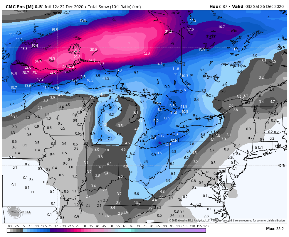
Christmas Eve 2020 Snow Potential
in Lakes/Ohio Valley
Posted
Still room for shifts. Extremely tight gradient but a lot of factors impacting the exact strength and track of that secondary low. The main thing imo is how much the trough digs. I'd say tonight’s 00Z runs will be key but tomorrow's 12z runs will give us the best clarity. Potential is there for either 1-2" (2-5cm) or 4-8" (10-20cm). Not going to write it off just yet.