

Snowstorms
-
Posts
3,925 -
Joined
Content Type
Profiles
Blogs
Forums
American Weather
Media Demo
Store
Gallery
Posts posted by Snowstorms
-
-
1 hour ago, Powerball said:
A part of me wants Detroit to see a winter of relative futility, just to see how @michsnowfreak would react.
I know if all else fails, February seems to always come through to save the day. That said, January so far isn't looking as hot as the broader pattern originally suggested for snow prospects in/around the Motor City (it's looking cold but dry)...
I think @michsnowfreak would go nuts if he experienced 4 of the top 5 least snowiest winters on record in a period of 10 years like we did in Toronto from 2006-2016. And if so, he can pull out any historic stat but I know there's nothing as unprecedented as experiencing 4 futility winters in 10 years.
That being said, February's are not as favorable for snow for our region as January is in El Nino's, especially strong El Nino's. But thing's can always change. Like how rare it is to get two sub 980 Low's in 4 days that both end up being cutters in an El Nino.
-
 3
3
-
-
Been snowing here since the morning. Almost an inch so far. Heavier rates moving in now with temperatures steady around the freezing mark. It'll likely remain as snow for the next few hours before a quick transition to heavy rain.
-
3 minutes ago, mississaugasnow said:
Tomorrow looks to be a good 2-4” for GTA before rain washes it all away in a few hours. 1-2” max down here.
Saturday storm looks like a redo of this current one. So Toronto is padding the stats but it’s gone within a few hours of falling.
This winters getting a F from me and I’m cheering for a top 5 least snowy lol. My actual guess is Toronto ends up with about 28” just outside top 5. Will have to look back at the records to see if it can be top 10 bad
You're right. The last few winters, although they've been above normal, we haven't been able to keep a snowpack because it's been so warm. And this winter so far is no exception. Last winter and 2019-20 are prime candidates. 21-22 was a solid A winter in my opinion. Jan 22 storm dropped a good 40-60cm (16-24") across the entire GTA.
The weekend storm has a lot of moving parts and variables so there's still time left for it to change. Should be a nice cold outbreak after the storm. But it may dry out for some time afterwards.
-
1
-
-
On 1/5/2024 at 8:21 AM, bluewave said:
The May to December pattern which got stuck in place related to forcing and record SSTs in the WPAC was unprecedented especially for Canada. Finally some colder weather in Western and Central Canada as the MJO interaction with the El Niño is leading to more of a -PNA pattern for a time this month. This previous interaction served to enhance the Nino pattern in Canada. Now it’s creating more of a Niña-like pattern with cold in the West and Plains down into the US for a period coming up.
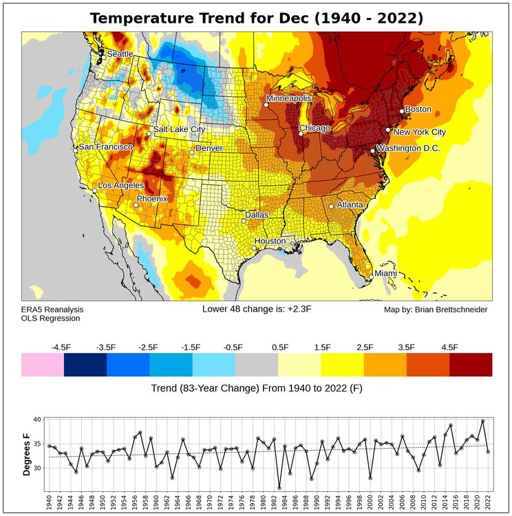
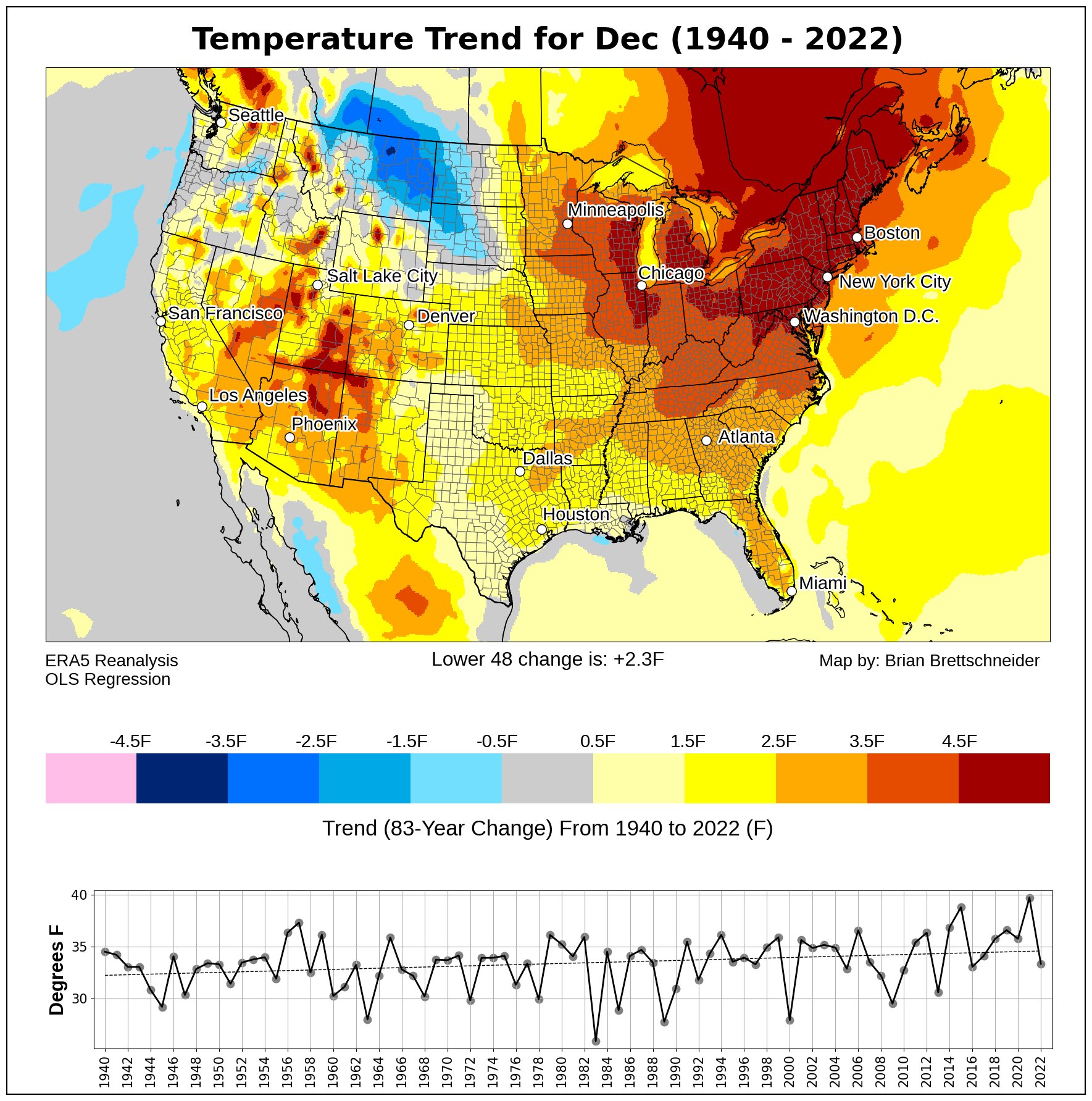
That explains why we had crazy wildfires over Canada this year and the numerous smoke days for us further south. I think at one point NYC was shrouded in smoke. That graph is pretty intriguing to me though. Obviously 2023 stands out like a sore thumb. But the downward trend in temperatures across Canada from 1942 to 1978 and the upward trend from 1978-1998 before it flatlined from 1998-present coincides well with the PDO phase. I'm surprised we didn't observe a similar downward trend in this current -PDO phase.
I guess time will tell if the WPAC warm pool is transient or permanent. It's certainly been playing a role in the influx of warmer winters for us. When did it really start?
-
1
-
-
1 minute ago, hlcater said:
???????
2 posts must be a troll or Alek's evil twin.
-
46 minutes ago, mississaugasnow said:
Lol Toronto is going to get back to back cutters that help prop up their seasonal total but turn to rain within a few hours of the onset.
still looking good for a top 5 least snowy winter because of the western cutters
We still got lots of time left. YYZ at 6.9" as of yesterday. Below normal, yes, but that's to be expected in strong El Nino's. But not all strong El Nino's are the same.
We've been on a good run since 2017-18 with every winter above average and 21-22 being a top 10 snowy winter. A good turnaround from the preceding 11 years where we experienced 4 of the least 5 snowiest winters on record. Those were some brutal years man.
-
2
-
-
30 minutes ago, Stebo said:
A panhandle hook is one of the classic snowstorm tracks for us. GHD blizzard 78 and 99 all were panhandle hooks.
For us bit further east especially eastern Ohio and further NE, some of our biggest storms are Gulf Lows or storms that track west of the Apps, i.e., Jan 22 or Mar 08.
-
Although temperatures will be marginal, the leading precip wave will be robust, which will keep thermals cool enough for 2-4" across the GTA, away from the lake, before it changes over to rain tomorrow.
-
2 hours ago, Allsnow said:
If we don’t get a inch of snow from this look I give up

That's a massive Aleutian ridge, wish it were a bit further east though. A 500mb pattern like that would probably mean a lot of clippers.
-
4 hours ago, michsnowfreak said:
Thanks for the links, I'll save them! When you go from having a snow machine in your backyard to painting your grass green & having palm trees in a humid continental climate, lmao. But yes, his posts are all trolling.
This december will likely be a top 5 warm December. We've only had 2 good cold and snowy Decembers the last decade, we've done actually decent with White Christmases, but December themselves have left much to be desired. What's really interesting is that we have no problem consistently getting early and late season snowflakes (Oct/May), November cold snaps and snowfalls, and loads of snow in February, but it's like pulling teeth to get a good December. Detroit's winter warming over the last 100 years is entirely from December, as Jan (-0.5°) and Feb (+0.5°) are a wash. There have actually been many winters in the past where december was by far the most severe winter month.. That did happen more recently in 2000, 2005, & 2016, but for the most part it's as if We are two completely different climates in december and february.
I agree. The biggest warming we've seen in winter is in December. It would be nice to get a string of cold Decembers (i.e., Dec 2007-Dec 2010) again but who knows. La Nina Decembers are typically cold and neither of the last 3 were cold lol. But just like you I'm a big winter enthusiast. However, I don't care much about Oct/Nov or mid-late March/April snow as much as I do about peak winter snow/cold. Anything outside of DJF until mid March is nothing more than a stat pad as it melts so quick because the climo doesn't support it. So to go an entire winter month without any snow/cold sucks.
But you're right how we don't need frigid arctic air to get snow across our region. 2019-20 or even last winter are a good representation of that. We can still get snow with marginal temperatures. That's how we ended up getting 60" last winter here in Toronto.
-
1
-
-
2 hours ago, brooklynwx99 said:
also, for like the millionth time, northern Canada can be +10 and it won't really matter for us since their normals are so much lower. it's always warm in Canada during Ninos, even in prolific periods
Yes I agree, some El nino's can be warm in Canada and some exceptionally cold. But right now most major cities are devoid of any cold. Most places in our "source region" across the Prairies, Northern ON, etc. have been running near or above freezing for the entire month and forecasted to remain that way for the next 5-10 days too. Which is way above average. There's zero snow out there too. Not even 2015 was this warm. Dec 1997 is probably the most comparable month to this year out west and across Canada. No other year comes close.
-
1
-
-
44 minutes ago, michsnowfreak said:
I was referring more down the road several weeks.
Going to be tough to get any sustained cold/snow out east until Canada doesn't cool down and build up snow cover. December 2006, as an example, was much colder across the entire "source region". And that winter didn't really get started out east until mid-late January 2007. Even Dec 2015 got colder by mid December out west. But current forecast keeps the entire west near/above freezing until the end of the month which is not good. Let's see if we experience a potential pattern change by New years and beyond. But the models continue to pushback the cold and I suspect they will continue to do so until the west cools downs. I don't think any of us will see any sustained winter until mid/late Jan - at least.
-
1
-
-
8 hours ago, mitchnick said:
Cloud cover /rain theory may work in the summer....may....but cloud cover in the winter maintains higher temps at night and those AN/BN are daily averages. I don't know how many times it has to be posted on this site (mentioned a lot in the MA and NE forums) that Canada can be above normal while below normal in the Conus because Canada normal is very cold in actual temps.
2 hours ago, michsnowfreak said:I got 37.1" of snow in a +5.0F winter last year. Temps are not the end all to begin with for people north of 40N. But when it comes to those temp departure maps, people really start to lose focus when getting hung up on departures. When you see Canada reds and southeast blues....its still way colder in Canada than the southeast. Average Jan high/low is 14/0 in Winnipeg, 13/-6 in Saskatoon, 0/-15 in Yellowknife....versus 43/25 in DC, 47/28 in Richmond, 53/33 in Atlanta.
Canada is NOT cold right now lol. Most major cities are experiencing record breaking warmth this December. Not even 2015 was this warm. And this is "our source region" for cold out east. Most places are near or above freezing.
See forecasts below for this upcoming week. These cities, more than 90-95% of the time, experience a white Christmas or at the very least some decent cold which is no where to be found this year. If you scroll down you'll find the averages too and will note how incredibly warm it is.
Calgary, AB:
https://weather.gc.ca/city/pages/ab-52_metric_e.html
Edmonton, AB:
https://weather.gc.ca/city/pages/ab-50_metric_e.html
Regina, SK:
https://weather.gc.ca/city/pages/sk-32_metric_e.html
Saskatoon, SK:
https://weather.gc.ca/city/pages/sk-40_metric_e.html
Winnipeg, MB
https://weather.gc.ca/city/pages/mb-38_metric_e.html
Thompson (north Manitoba)
https://weather.gc.ca/city/pages/mb-34_metric_e.html
Moosonee, ON (right by Hudson Bay)
-
2
-
-
22 hours ago, michsnowfreak said:
Few things.
#1) Where can you browse toronto's climate data online? I really can't find non-US stations or at least detailed data of them. And they need to get with it (updating the normals) as it's almost 2024 haha
#2) If you REALLY have been following, you would know nobodys denying climate change, they're mocking a troll that everyone is tired of. Have you ever actually seeing some of the things he has said? Most of them arent even acknowledged or replied to, they are so outlandish and ridiculous. He doesn't like stats. Just will say your in denial if you don't think Toronto winters will warm 30° in 20 years.
#3) funny you mention having warm Decembers close together. 3 of Detroit's top 4 warmest Decembers occurred in 1877, 1881, 1889.
You can find all the climate data below for YYZ and Toronto (goes back to the 1800s). I also created an excel spreadsheet, that I update every month, with the monthly snowfall total and mean (DJF) temperature for YYZ that I'd happily share with you if you'd like.
From June 2013 - present:
https://climate.weather.gc.ca/climate_data/daily_data_e.html?StationID=51459
From 1937-June 2013 (YYZ):
From 1840 - 2017:
LOOL, you're right. I agree he's definitely trolling. I think deep down he's just frustrated with the crappy start to this winter and I guess the last few winters.
And I understand 1877, 1881, 1889 are top 5 right now. But once all is said and done, 2023 will likely be a top 5 or at the very least top 10 warm December for Detroit (given the forecasted temperatures for the next 5-10 days). Dec 2021 was also incredibly warm in Detroit too and 2019 is also up there too. So although Detroit experienced 3 warm Decembers in a period of 12 years, it's experienced 4 (top 5 or top 10ish) warm December's in 8 years and if extended back to 2011, then you find 2 more warm Decembers (2011, 2012). The point I'm trying to make is, these extreme or anomalous warm months or periods are happening more frequently now than they did 50+ years ago. In the same 12 years (2011-2023) vs (1877-1889), Detroit's experienced 6 really warm Decembers and a few slightly above average (2014, 2018, 2020). At this rate, December is slowly becoming a non-winter month lol which sucks because it's the shortest month of the year with the lowest sun angle.
-
1 hour ago, Hazey said:
Most if not all capital cities in Canada will not have a white Christmas, including some traditionally cold areas like the prarries. My wife is from Winnipeg and is going home for Christmas. No snow otg and temps in the 40’s for Saturday. Green Christmas assured. Very unusual for them.
Yeah nothing on the ground here in Toronto too. Had an inch yesterday but that melted this afternoon and expected to be in the mid 40s on Christmas.
-
2 hours ago, hardypalmguy said:
Coping is a hard drug to get off, eh?
Been following all these posts and I decided to take a look at the stats myself and just say a few things. For the record, I denied climate change for a long time or at least the severity of it. I looked at all the strong/super El Nino's since 1950 (using ONI) and looked at the monthly average for each month in Toronto. The 1981-2010 average is 28.1F for Toronto. The 1991-2020 average isn't out yet for us and I don't think it would be a good baseline to use when looking at winters pre 1980, anyways.
When I look at this, two things stand out. One being the anomalous warmth in 2015 and 2023 when compared to other strong El Nino's and the other being the timing. You'd be hard pressed to find two potentially top 5 record warm December's in such a short amount of time (i.e., 8 years) in any other point in history. You might as well add in December 2021 in there because it was also another top 5 or top 10 warm December (for most of us). Now to add the icing on the cake. These two December's are looped in a string of warm Decembers that we've been experiencing since 2011. On a grander scale, it's obvious things are warming and we are seeing a lot more anomalous warmth than we did before. Hard to deny the truth at this point.
-
1
-
 1
1
-
-
2 hours ago, michsnowfreak said:
Most winters, even the mildest ones, Chicago will easily see one or several stretches over 3+ days below freezing. Likewise, the chances of an entire month straight below freezing, even in the coldest winters, is extremely rare.
An entire month below freezing is rare, yes, but they can happen, at least for us here. The most recent being February 2015 where YYZ stayed below freezing the entire month (warmest day was 29F). In total we stayed below freezing for 37 straight days.
From Jan 5 to Feb 12, 2011 we stayed below freezing with the exception of 3 days, but they were barely above freezing and only a for few hours too.
Another recent one was Jan 14 to Feb 18, 2007. Only two minor days above freezing in that stretch but both were below 33F.
-
2
-
-
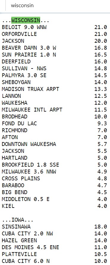
On 11/1/2023 at 11:02 PM, Chinook said:
Anybody remember this snow storm? It sort of maxed out in and near Cedar Rapids to Madison Milwaukee on 2/6/2008

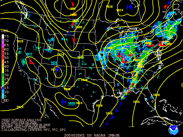
Was an amazing storm up here. We got between 13-20" coupled with thunder snow.
-
1
-
-
About 11" here. Nice paste job. One of the heaviest snows I've ever shovelled. The thunder snow last night was epic though.
-
3
-
-
-
YYZ reporting +SN and 0.2 mile visibility right now. Heard a lot of thunder earlier with over 25 strikes confirmed in the city. What a storm
-
6
-
-
3 minutes ago, SolidIcewx said:
According to my Apple Watch the pressure has dropped 3.3mb in the past 45 mins or so
rather sophisticated watch
-
 1
1
-
-
All models are aligned for 12"+ for Toronto and surrounding areas. HRRR has peak snowfall rates of 2-4" per hour. With strong easterlies off the lake, we could definitely see blizzard like conditions.
-
1
-
-
10 minutes ago, michsnowfreak said:
2020-21 was not a very mild Winter here at all. Even in the mild Winters the past decade we've had some good cold storms. There's just been a lot of bad luck this year. Hell, even we all had an extremely cold snow fall in December this year. But sorry, it's absolutely ridiculous to say DTW will become the new CMH. Even if our Winters magically warmed 4 degrees, We are surrounded by the Great Lakes which Columbus is not. I mean climate change is real but the way one mild Winter with subpar snow jades people is really over the top.
Dtw temp departures last 10 winters
2022-23: +5.0
2021-22: -0.4
2020-21: +0.3
2019-20: +4.2
2018-19: +0.5
2017-18: -1.1
2016-17: +4.5
2015-16: +5.1
2014-15: -5.1
2013-14: -7.5I see a lot of (+)'s in there haha. But realistically I ain't just considering it on a trimonthly basis but also on a monthly scale. 2020-21 for the trimonth (DJF) was +0.3C but that doesn't paint the whole picture because Dec and Jan were warm. 2017-18 was cold, yes, but we torched like crazy in February. Ironically we did so in both Feb 2017 and 2016 too. Record warmth I might add. And now Feb 2023 is in there too.
But also going back to this storm. Detroit could be in the jackpot zone. GFS has a rather robust FGEN band cutting through the area. Could potentially be the first 12"er in a while, no?
-
 1
1
-

El Nino 2023-2024
in Weather Forecasting and Discussion
Posted
Interesting. I think the rapid warming coincides well with the PDO phase. I believe the PDO plays a huge role in temperature variations across western NA. The 2015 super Nino may have been the tipping point that may have played a role in the WPAC warm pool. Time will tell if the current Nino or a strong Nina can reverse the warming. We haven't had a strong Nina since 2010-11 (as per ONI) despite experiencing a multi-year Nina.
Although Mar 2012 was exceptional, I'm not too strung up about it. We've had exceptionally warm Marches before. Mar 1945 and 1946 are key examples that come to mind.