

Snowstorms
-
Posts
3,925 -
Joined
Content Type
Profiles
Blogs
Forums
American Weather
Media Demo
Store
Gallery
Posts posted by Snowstorms
-
-
3 hours ago, 40/70 Benchmark said:
Plenty of strong El Ninos were decent, but unfortunately this wasn't one of them. Over the past several years it really hasn't mattered what ENSO has done because the extra tropical Pacific has sucked. Anyone who has a clue knows this wasn't a prototypical super El Nino with a huge GOA low...its sucked because we can't shake the west PAC warm pool that continues to favor Maritime forcing, regardless of ENSO.
That WPAC warm pool only became an issue after the 2015-16 super nino. We saw several cold winters between 2000-2015. Perhaps a strong Nina may help to cool it. We just came out of a multi-year Nina but they were all weak except 2020-21 which was moderate. I'm just grasping at straws. I'm tired of these warm winters myself.
-
 2
2
-
-
20 minutes ago, cyclone77 said:
Have had 0.3" here in the past 29 days. It's been done lol
Wow. Yeah you're right and tonights GFS has zero for the next 15.

At this point I'm hoping for a full on torch for spring.
-
1
-
 1
1
-
-
7 hours ago, bluewave said:
Yeah, pretty ridiculous heat in that part of the world keeps reloading the forcing leading to more jet extensions and warmth for us.


I hope the warmth is temporary. One thing that seems apparent to me, and I think this principle can be applied to many places, is that we seem to be seeing a lot of micro trends. Like one region goes through a drought for a period of time then a wet period, etc. This WPAC warm pool really became an issue after the 2015 super Nino. Maybe a strong Nina, since we haven't seen one since 2010, might help cool it down?
From a national perspective, we saw several cold/cool winters from 2006-07 to 2014-15 (2007-08, 2008-09, 2009-10, 2010-11, 2013-14, 2014-15). Quite the opposite from 2015-16 to present.
-
1
-
-
39 minutes ago, hawkeye_wx said:
The op GFS is really blowtorching the end of the month. It has been showing this for several runs. Frankly, I hope the heat gets dialed back quite a bit as we get closer. It's way too early for that.
Yeah would be quite historic too. But the way this winter has gone, I wouldn't be surprised if we saw a warm March like 2010 or 2012.
-
That GFS 384hr total snow map is depressing. Stick a fork in this winter, it might be done.

-
7 minutes ago, 40/70 Benchmark said:
Sometimes in an active N strema year, the N steam goods can get you en route to the phase at the coast...probably what happened in years like 77, 04, 08, 10, 13 and 17
The February 2013 storm is a prime example of this. Clipper and coastal phase due to an active N stream.
-
1
-
-
1 hour ago, SnowGoose69 said:
I have to check the 72-73 anomalies at 500 which was more of a -PDO Nino. But I think it resembled as PSU said in the MA forum the classic pattern that used to work for us and even the SRN US but no longer does with the -AO/NAO and -PNA but you did not have the stupid ridging in the SE we always see now in that pattern
I agree. Perhaps the +AMO is playing a role in driving the SE ridge? The AMO has been positive since the mid 90's and could definitely be enhancing the SE ridge with the warmer Atlantic. Both the PDO/AMO were negative from the late 50s till the late 70's which led to many cold/snowy winters. Although the 80's and early 90's weren't particularly snowy, they featured a lot of cold winters which may have been driven by the -AMO.
-
2 minutes ago, SnowGoose69 said:
Most strong Ninos feature the raging E Pac vortex which was largely absent this winter
I believe that WPAC warm pool may have contributed towards that as @bluewave mentions every so often.
-
1
-
-
34 minutes ago, SnowGoose69 said:
Most likely yes, the fact Canada just was stupidly warm...even 09-10 it was not that cold of a winter at all outside of the southern tier of the US...Canada was largely torched that winter too
I beg to differ. This winter seems typical of a strong El Nino. It may not finish as a "super" El Nino but it's definitely a strong El Nino, similar to 1972-73 and 1965-66, both of which fell short of super status.
December 2009 was well below average across most of western Canada. Jan 2010 was near average for the southern Prairies and February 2010 finished below as well. Polar opposite of this winter. The "source region" was much colder with a solid snow cover hence it led to more snow for you guys in the Mid Atlantic/East coast as the AO/NAO block suppressed every storm. The block kept all of northern Canada warm but that's normal in a strong blocking pattern. Quite different than this winter where most of Canada will finish above average driven by a warm Pacific.
See climate data in the link above. Regina averages -12.4/-14.7/-11.7C, respectively for DJF.
-
On 2/15/2024 at 8:39 AM, LibertyBell said:
Thanks.... Do you think Mitchnick is right in his thinking that we need a very strong la nina to entirely change the pacific pattern?
We haven't had a strong La Nina since 2010-11 despite seeing a multi-year Nina recently. So maybe it could. Things certainly changed since the 2015-16 super Nino which may have led to a warming effect across the entire pacific. 80% of the winter months (DJF) since 2015-16 have finished above average for most of us.
I don't think the -PDO is the primary driver of this warmth. The PDO was ~75% negative from 1998-2014 and we saw plenty of cold winters (2000-01, 2002-03, 2004-05, 2008-09, 2009-10, 2010-11, 2013-14) and some featured incredibly cold winter months (i.e., Jan 2000, Jan 2004, Feb 2007). And during the last -PDO phase from 1948-1978, we saw plenty of cold winters.
-
1
-
-
3 hours ago, mississaugasnow said:
Yep, Im a big fan of snow on ground. 36 days with at least a trace of snow on the ground. The highlight was 15 in a row in mid January
We didnt see as much melting as you guys yesterday. Grass is still covered here and a few squalls overnight helped. So Should be able to make it to Tuesday with snow on the ground
A few days of snow on the ground after going nearly a month without any snow on the ground during prime winter isn't going to change my perception about this winter. A 7-10 day cold shot in January which was preceded by top 5 warm Dec-early Jan and warmth since then, won't make this winter seem any better. It's been truly garbage from start to finish.
Two back to back incredibly warm winters and the 4th warm winter in the last 5 years. And the only truly cold winters, the ones that featured more than a 2 week cold shot, since 2015-16 were 2017-18 and 2021-22. But even those two featured incredible warmth (Feb 2018 and Dec 2021). It's crazy how many warm winters we've seen lately. This stat is even more profound for areas further east and north.
-
2
-
-
20 hours ago, bluewave said:
Ridiculous warmth in Canada for the first half of February.
Wow! I did not realize how warm the Prairies were running this month. That's insane. 1877-78 was also a powerful strong/super nino. Well if our source region is running warm with little to no snow cover, you can't expect to see any sustained cold further east. Which is why I was always skeptical of any pattern change that was being modelled. I don't know if you recall, but the models showed something similar back in early-mid Dec 2015 too, but it never materialized.
So far February 2024 is running to be the warmest Feb on record in Toronto.
-
All of the top 5 warmest Feb days at YYZ have occurred in the last 8 years lol. That's f*cked up.
https://x.com/gtaweather1/status/1756061770123268267?s=20
Without a doubt, since the 2015-16 super Nino, we've experienced record breaking warm winters. It's hard to say if this is the new norm now, but certainly feels that way. Don't think we've experienced a string of cold winters, to the severity of the warm winters that we've experienced in the last 8 years, in a long time (since the early-mid 80s).
-
1
-
-
Today's GFS run is just depressing. No real snow or threats through Feb 20. Just looks cold and dry. We're about to go nearly a month without snow in the heart of winter. December was snowless too.
Garbage.
-
3 hours ago, LibertyBell said:
The middle three years were really awful, the first year wasn't that good either, it was just one storm, and we were on the edge of it lol. Look up the snowfall totals of 1965-66 for DC and Norfolk, Virgina. And that was a strong el nino and has been used as an analog for this season. The following year we were at cold neutral close to weak la nina and look how great 1966-67 was for snowfall. So maybe next season we'll finally get a good season. I'm not expecting 1995-96 or 2010-11 type la nina after el nino, but hopefully we'll get closer to average snowfall next season.
That 2015-16 super Nino screwed things up and since then, the WPAC has been incredibly warm. Maybe a strong La Nina might offset the warmth and cool it down, idk? Despite the multi-year Nina, we haven't had a strong Nina since 2010-11. We had many cold winters during the last multi-decadal -PDO so I don't think it's the driver of this warmth.
You can add 1917-18 to that list. I'll take a repeat of that winter. It was a La Nina following an El nino.
-
1
-
-
19 hours ago, mississaugasnow said:
Whats the percentage you put at Toronto and Detroit seeing another 10" of snow this winter?
10" more would push Toronto out of top 10 least snowy winter.
Construction has resumed/started real early. Got the earliest email in my near decade of running my division asking if we have begun the 2024 season. Ill send back we dont resume for another 6 weeks still but crazy to see.
Forecast looks bleak. Next weeks storm looks to slide south of us and no real fantasy storm after that other than a weak clipper. With the amount of snowless weeks and the abundant sunshine and warmth we've seen over this past week, I'm ready for spring. Another one or two week long cold shot with little to no snow isn't going to makeup for this. 56 (13C) right now at YYZ on Feb 9th.
Outside of that one week in January, it's been a total shit show. What a garbage winter and second record breaking warm winter. Almost like the stretch of warm winters we had from 1997-2000.
Since that 2015 super nino, we've truly only had 3 cold winters (2017-18, 2018-19, 2021-22). The remaining 6 including 2015-16 were warm and in some cases, record breaking warm.
-
2
-
-
7 hours ago, bluewave said:
Quite a snow cover extent roller coaster ride this winter across North America.
https://www.star.nesdis.noaa.gov/smcd/emb/snow/HTML/snow_extent_monitor.html

Goes back to one of your posts about the increase in extreme weather lately. Dec 2023 was incredibly warm followed by a record breaking cold outbreak, out west, and now more record breaking warmth for the same regions.
-
1
-
-
29 minutes ago, MANDA said:
Can still get very meaningful cold in February but you are 100% correct that the lack of ice on the Great Lakes + late February sun angle + possibility of bare ground upstream will certainly temper what could have been if the lakes were ice covered and some snow was on the ground. Sun angle we can't help.
I live in between the 3 Great Lakes and ground is barren here in Toronto. I was up north over the weekend and only those downwind of the lakes (thanks to lake effect snow), have snow on the ground (4-6"). But with the warmth this past week and continuing warmth for the next 10 days, it'll all melt. No ice on the lakes either.
I was in NYC/LI the last 2 days for a work conference. I didn't know it was gloomy here too.
-
1
-
1
-
-
On 1/31/2024 at 10:26 AM, michsnowfreak said:
Im wondering if this is similar to 1877-78, where the core of the warmth was centered in MN/the Plains? While it was certainly a mild winter here in 1877-78, it wasnt nearly the magnitude of out there. To date, 1877-78 stands as Detroits 16th warmest winter on record. Other winters of that era of up-and-down winters that rank higher on Detroits warmest list are 1881-82, 1879-80, and 1889-90. The warmth and lack of snow in 1881-82 & 1889-90 is FAR more impressive here than the mild winter of 1877-78 which actually saw slightly above avg snowfall. While December 1877 is Detroits 5th warmest on record, January and February 1878 dont even make the top 20. Meanwhile, there is tons of documentation and stories about how wild Minnesota's Year Without a Winter was in 1877-78, and it appeared even worse in Duluth than Minneapolis. (Duluth was warmer than Detroit in Feb 1878!)
And same here. The warmest temp this January at DTW is 44F. Only 29 years of the 151 years on record saw a lower max temp in January.
How much snow did Detroit receive in Dec 1877? Dec 1877 is the least snowiest ever on record here with only 0.3". Dec 1877 is the 7th warmest on record here. 2015 and 2023 take the cake for top 2 though.
1889-90 was the warmest of the 4 winters you mentioned with a mean DJF temperature of 30.3F in Toronto. I haven't looked at the warmest/coldest winters in Toronto yet. I only have for YYZ (going back to 1938). The 30.3F would make 1889-90 the 4th warmest on record, behind 01-02, 11-12, and 15-16, respectively, since 1938.
However, temperature records, especially over the last 30-40 years would definitely be impacted by UHI and urbanization, especially overnight lows. I don't know how applicable this principle would be for Detroit, but most major weather stations are either in the city or at the airport which can cause a "heat island" effect. Not trying to discredit climate change here though.
But seeing how warm some of those 1800 winters were that you mentioned, in a time where there was no "industrial revolution" or "UHI" is pretty impressive.
-
1
-
-
1 hour ago, OrdIowPitMsp said:
Closing out January with record high temps across Minnesota today. The all time January record of 56 in Minneapolis might be in jeopardy today.
Damn. Seems like the warmth has been centered around Minnesota and further NW this month. Our warmest high this month was 43. Last time we hit 50 was Dec 15. Nonetheless were going to finish January 7 degrees above average lol.
-
Tonight's GFS is snowless for all of us until Feb 15 or all 384 hours. Nice.
-
2 minutes ago, mississaugasnow said:
Found North York but incomplete data for January so far.
Assuming its a bit higher compared to YYZ, North York is probably around 18" whereas YYZ is 16"
Hamilton is at 10.2" on the year.
That one storm in mid January has created a big gap across the GTA
And the next 10 days look snowless too. Unless things turn around late Feb and March, were currently on track for a top 5 winter. Your call still going strong haha.
Below is the Toronto station (going back to 1840).
-
1
-
-
@mississaugasnow When I actually went back and tallied up all the winters in Toronto since 1840 I couldn't believe it. Almost wanted to rage lol. A lot of the winters in the 1800's were incredibly snowy and cold especially from 1864 to 1877. Toronto averaged 224cm (88") in this 13 year period lol. Out of those 13, 4 were >100".
It's even more ridiculous when you extend the timeline. From 1843 to 1877, Toronto averaged 72" or 184cm in this 34 year period. The least snowiest winter in this entire stretch was 35". Fooking crazy.
No other period in history has come remotely close to this. And I can't explain why. Maybe little ice age hangover?
-
1
-
-
On 1/26/2024 at 5:48 PM, michsnowfreak said:
Detroit can do good in weak el ninos. Strong are the worst. Do you have Torontos top 20 least snowy?
Yes I agree. Some weak or moderate El Nino's can be great for us too. Sorry it took me a while to get back to this, had to total up all the winters since 1840 in Toronto lol. Here's our top 20 least snowiest winters. Note I did not use YYZ for the top 20. I used our Toronto station, from 1840-1994 and then used our North York station from 1994-present.
The red highlighted are the more recent winters (i.e., since 2000). Our average snowfall every winter is around 50" (45" at YYZ).
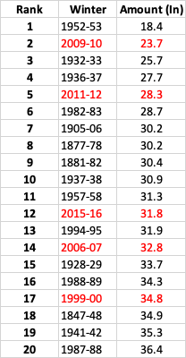
If I used YYZ then 2011-12, 2009-10, and 2006-07 would be in the top 5. But YYZ's measuring standards are questionable.
-
1
-


Winter 2023/24 Medium/Long Range Discussion
in Lakes/Ohio Valley
Posted
I agree. '83, '98, and '16 all had similar type of March patterns.
As @michsnowfreakmentioned all three had a cool down sometime mid-late March. Although in 2016 it happened in early April. But no guarantees it will happen this year. This winter has been on life support since it started.