

Snowstorms
-
Posts
3,924 -
Joined
Content Type
Profiles
Blogs
Forums
American Weather
Media Demo
Store
Gallery
Posts posted by Snowstorms
-
-
4 minutes ago, donsutherland1 said:
For reference:
Edmonton International Airport's all-time low: -48.3C (-55F), January 26, 1972
Edmonton Area's all-time low: -49.4C (-57F), January 19, 1886
Wow. So this cold outbreak is historic then. I think what makes it even crazier is the 180 degree pattern flip from December. Let's see if we can break some records then.
-
 1
1
-
-
3 minutes ago, Volcanic Winter said:
Not to derail but Canada Goose is an overpriced fashion brand. They’re very warm but also obscenely expensive. Can get a better made down jacket that’s as warm or warmer from Feathered Friends for a fraction. I’d take Arcteryx over CG too, or Patagonia. Expensive still, but more technically competent than CG’s offerings. Just IMHO. We went into a CG boutique in Reykjavik this November and the price for their parkas were absolutely laughable, was like $2500 for the women’s warmer variant.
Oh I completely agree. It's way overpriced like everything else is in Canada but that's a topic for another day lol. I have an Eddie Bauer jacket. Does me good every winter. It doesn't get cold in Toronto like it does in western Canada but we typically get cold nights here and there between 0 and -15F almost every winter.
Maybe i'll consider investing in an Arcteryx jacket too. Might be useful if I decide to go hiking or snowmobiling.
-
1
-
-
1 minute ago, michsnowfreak said:
I don't disagree that april snowfall is stat padding, but it still counts.
I consider it stat pad when you factor in seasonal averages. I'm not sure what the average high in Detroit is in early-mid April but I'm sure its probably close to 45-50F which is nearly 20 degrees above freezing. If you're a snow cover lover, April snow isn't your friend. It'll melt within 2 days with that high sun angle and warm climo. But I guess we can agree to disagree.
-
1
-
-
3 minutes ago, mississaugasnow said:
Good catch. But still very very rare and not really worth discussing April snow like it’s going to give us a legit winter storm. Similar to early November snowstorms
It won't but it's possible. April snow is just a stat pad. Most April/November snow is nothing more than 2-3" with that rare/odd 4"+ storm. We had a 8-9" snowstorm back in Nov 2020. Melted within 2 days because it was so warm which is why I don't care about early or late winter snow.
-
11 minutes ago, Volcanic Winter said:
I do winter hiking and you would legitimately need expedition down parkas to be out in that, like Everest style down suits. I have a very heavy 240g fill weight down jacket suitable for below zero temps but even layered with that it would be too cold, and this is a substantially warmer parka than what most people have. Like you can’t even wear it around freezing you’ll sweat your ass off. I’m sure living in Canada most are well prepared I’m just saying that is most certainly “nuts” cold.
A lot of folks, especially in western Canada, have moose knuckles or canada goose jackets. Though I don't know how effective they are at -50F lol. But I don't think even your parka would be enough, you'd need to wear a thick sweater underneath along with scarfs, gloves, hat, etc.
I have a cousin living in Calgary right now, I could ask him what they're doing. But I believe they urge people to stay indoors and park your cars inside a garage or risk it not starting up. I think they might even plug their cars. This type of cold outbreak is rare, even by their standards. On average most cold outbreaks are between -25 to -35F in that area.
-
1
-
-
Just now, mississaugasnow said:
Officially I think that was 4”
5.5" at YYZ.
-
1
-
-
4 minutes ago, mississaugasnow said:
Main winter season in GTA with realistic chances at a winter storm are November 15-March 15
there’s the rare years a storm happens just on either side of those dates
Ive never seen a 6” April or October snowstorm
An October snowstorm is incredibly rare. I think it's only happened twice since 1938 at YYZ. There's less than 1% chance of it ever happening. And April 2016 we saw a nice 6" storm here in Toronto. Had it not been for that storm, we would've finished only an inch above 11-12.
-
1
-
-
19 minutes ago, michsnowfreak said:
4 top 5 futility, yikes I would be as ornery as cromartie. I would definitely agree that nobody in the forum knows futility as much as Toronto (relative to their average that is). We've had futility months and we certainly have had undesirable winters. But this is why I constantly harping on the fact that regardless of how bad a pattern looks, when you live in a region that gets snow thru April, you just can't jump the gun early.
For each of those winters, one month finished average while the rest were below to exceptionally below (almost futility months). I believe the 10 year stretch of futility winters we experienced is similar to the ones a lot of the folks down in the mid-atlantic are going through at the moment. 06-07, 11-12, and 15-16 were just down right bad. 09-10 had potential but to much blocking suppressed every single storm.
April snow or November snow are nothing more than a stat pad. I could care less knowing it'll melt within 2-3 days max. I care about what falls between DJF until mid-march. And December and half of January now are pretty much a write-off and the next 10 days look cold and dry.
-
1
-
-
2 hours ago, MANDA said:
Temperatures near -50F across parts of Alberta this morning. That is First Class, Grade A cold. Something not seen every year that's for sure and certainly not in the recent past.
https://weather.gc.ca/city/pages/ab-71_metric_e.html
It's currently feeling like -72F in Edmonton. -54F tonight and -58F tomorrow night in Edmonton without windchills. This is ridiculous cold.
-
1
-
-
Majority of the snow with this storm will fall within 2-4 hours today. All models have a very intense snow band pushing through between 6-10pm today. Snow rates will likely be 2-4"/hour with the possibility of thunder.
Areas away from the lake have a good chance at 3-6". I can't say the same for you further south but just referring to the GTA @mississaugasnow.
-
1
-
-
39 minutes ago, michsnowfreak said:
Oh top 10 is definitely futility. I'd say anything over 20" is just below avg. The lowest winter of my lifetime is Detroits 16th least snowy (1997-98, 23.4"), although I was in my mother's womb during 1982-83 lol (11th least snowy, 20.0").
I wonder how you'd feel or react if you experienced 4 top 5 futility winters in a mere 10 years. I don't think anyone on this forum knows futility better than us in Toronto. Although in those same 10 years, we had exceptional winters like 07-08, 08-09, and 13-14, the stinkers outweigh the good ones. Here's the numbers from YYZ just for laughs.
06-07: 23.7" (4th)
09-10: 20.6" (2nd)
11-12: 16.9" (1st)
15-16: 25.9" (5th)
For snow lovers in Toronto, this was a nightmare. On that note, since 2019-20 every winter except 21-22 has been warm to exceptionally warm. Although we finished above average, it was all by luck. All marginal snow events which goes back to what @mississaugasnowwas saying. Would be nice to experience both cold and snowy winters like the 60s and 70s featured. We're basically reliving the late 80's and early 90's right now.
-
1
-
-
3 hours ago, mississaugasnow said:
When's the last time we saw so much vanishing snow? Toronto is up to 5" on the month but it's a lot of events like yesterday where it melts within a few hours of falling. Im still pretty convinced top 5 least snowiest season is very doable but we keep seeing 0.5-1" days haha
Ill have to check data again but I believe top 10 in the last 90 years is a near lock
Half that 5" came from the storm earlier this week that washed away a few hours later. Without any sustained cold, the snow can't stick around for more than a few hours. That'll likely change tomorrow but the pattern dries up too lol. That's the primary issue with some Nino's. You may have a juiced up STJ that may offer up bigger storm opportunities than Nina's, but the upper air pattern in Nino's sucks for our region which leads to either suppressed or upper great lakes storms. Some Nino's are great, some not.
-
40 minutes ago, A-L-E-K said:
call looking $$$
been saving this one after i seen it on the road, for this message.

-
2
-
 8
8
-
-
1 hour ago, mississaugasnow said:
So I wonder if that's the new normal going forward. A bit similar to I95 cities. Feast or famine starts to become typical
Actually the inverse is pretty bad too. Been a battle of extremes over the last 20-30 years. An actual feast vs famine. For example, Dec 2006, Dec 2015, and Dec 2018 are the 1st, 2nd, and 4th least snowiest December's on record at YYZ, respectively. 7/10 least snowiest December's on record have occurred since 1998. If expanded to top 13, then its more like 10/13 since 1998 lol.
-
4 minutes ago, michsnowfreak said:
Snow slowly melted throughout the day today, got up to 37 and remains damp.
Ain't been the winter for snow cover, so far. Hope things change. But after this storm, things dry out for the next 10 days lol.
-
1
-
-
8 minutes ago, mississaugasnow said:
I think, Ohio, SE Michigan and Southern Ontario (especially Lake Erie shoreline) are hoping the GFS wins out. It's been consistent with a band of 2-4" an hour rates for a while now.
Most of that 2-4"+ will fall within 3 hours with a robust leading frontal band. If it holds up and temperatures are cold enough, it'll be an intense 2-4" per hour rates for 2 hours before it switches to light snow and drizzle lol.
Might also be some thunder.
-
1 minute ago, mississaugasnow said:
Ya, my new location has meant famine. We got 6" last March
Ya if we were above freezing up here, it would've been too warm for you down south then. And now we're both on the cusp of rain this year haha.
It all started since that 2015-16 super nino. I wonder if this will become the new norm or it's just an anomaly and we are still dealing with it's effects (i.e., WPAC warm pool).
-
13 minutes ago, mississaugasnow said:
So I wonder if that's the new normal going forward. A bit similar to I95 cities. Feast or famine starts to become typical
I can't lie though, apart from 21-22, every winter since 19-20 we've been extremely lucky. 90% of the major snow fell with marginal temps. For example, temperatures were around 31-33F with that March storm last year that dropped 10-12".
And if we continue on this warming trend, it may just become feast or famine. And these two storms this week are exposing it nicely. 40+years ago if we had two sub 980 low's in a week, with a track like that, we'd be buried.
-
4 hours ago, MANDA said:
Expansive area of -30C to -40C cold across central Canada this morning. Currently -43C at Yellowknife, NWT and -46C at Old Crow,YT.
Think it is safe to say the cold has moved to our side of the pole....at least for now.
Rather impressive and dangerous cold out west. Red Deer, AB (in between Calgary/Edmonton) forecasted to drop to -50F over the next 2 nights which is only a degree or two away from the all-time Jan record low of -52F. Records go back to 1904 there. Let's see if they break it.
Hoping it moves east and helps increase all of our snow chances. Two sub 980 low's cutting through the lakes this week, which in an ideal world would be amazing for us, but it's been way too warm. We got 2" with the first storm followed by an inch of rain and maybe another 4" tomorrow then rain showers lol. This pattern blows.
-
2
-
-
24 minutes ago, IWXwx said:
Oh, I don’t know, it may have been kind of fun having him around with this upcoming arctic dump.
him:
-
1
-
3
-
-
@mississaugasnow I looked at the records to rank the snowiest month's on record in Toronto. I used North York since YYZ sucks. North York only has records going back to 1995 so the rankings are a combination of YYZ (pre 1997) and North York (post 1997). I filtered out any snowy month pre 1997 as I was only focused on the rankings for the last 20-30 years. So the rankings are from 1938-2023.
Note: If we were to hypothetically include all Toronto records that go back to 1840, then Mar 1870 takes the cake for the snowiest month on record, by far. A staggering 62" in one month lol.
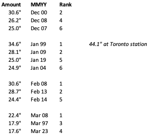
We can appreciate the fact that we've experienced the snowiest Jan (x2), Feb (x2), and Mar (x2) on record. Dec up there as well with 3 top 6, but Dec 1951 takes the cake with 34.1" (which btw was a moderate Nino).
-
About 1.5-2" so far. Still snowing lightly but temperatures rising fast and up to 33 now. Stat pad lol.
-
1
-
-
42 minutes ago, mississaugasnow said:
Im hoping we can get enough of a front end dump and backside 1-2" that we aren't fully looking at bare ground next week with the cold. Toronto saw 5cm yesterday so up to 23cm on the season.
Might be another thread the needle event. With the marginal temperatures, it won't be anything crazy but should push Toronto above 30cm for the season. Yeah last thing I want is bare ground and extreme cold like how Jan 2015 was. Here's a list of Toronto's biggest snowstorms since 1995. I used North York cause YYZ is a joke. It sucks Environment Canada has gotten rid of so many reporting stations over the years meanwhile our American counterparts have a station in every county lol.
I didn't know how to make the image smaller, my bad lol.

-
1
-
-
On 1/8/2024 at 7:23 PM, bluewave said:
The rapid warming began in 1981. But March 2012 may have been the first time it became so pronounced. Then we had the record event in December 2015. Followed by the record MJO 4-7 activity continuing up to the present day.
https://www.nature.com/articles/s41586-019-1764-4
https://www.weather.gov/media/lot/events/March2012/March_Heatwave_2012_final.pdfhttps://phys.org/news/2021-04-distinctive-mjo-super-el-nino.html
Interesting. I think the rapid warming coincides well with the PDO phase. I believe the PDO plays a huge role in temperature variations across western NA. The 2015 super Nino may have been the tipping point that may have played a role in the WPAC warm pool. Time will tell if the current Nino or a strong Nina can reverse the warming. We haven't had a strong Nina since 2010-11 (as per ONI) despite experiencing a multi-year Nina.
Although Mar 2012 was exceptional, I'm not too strung up about it. We've had exceptionally warm Marches before. Mar 1945 and 1946 are key examples that come to mind.
-
1
-

Winter '23-'24 Piss and Moan/Banter Thread
in Lakes/Ohio Valley
Posted
Nah. The stats you see in my sig are of my own and I can tell you personally all 4 of those winters were bad to downright hideous. 09-10 sucked for us because every storm was suppressed thanks to the massive NAO block. I know areas just 100-200 miles further south had a completely different winter. 06-07 and 15-16 were virtually snowless until mid January.