

Snowstorms
-
Posts
3,925 -
Joined
Content Type
Profiles
Blogs
Forums
American Weather
Media Demo
Store
Gallery
Posts posted by Snowstorms
-
-
14 hours ago, Stebo said:
I mean December is obviously doing all the heavy lifting on these numbers. It was still a significant cold snap that we went through, to say otherwise is foolish.
Maybe for Chicago, Iowa, Wisconsin, and further west, but it wasn't anything special for us further east. Our average low in Toronto is 12F right now and the coldest we got was 4. I'm sure the same could be said for Detroit with the exception of 2-3 cold nights where you dipped below 0.
And it only lasted a week. Now we are back to reality (continuing warmth). And it'll likely erase any negative departures for Detroit.
-
 2
2
-
-
On 1/24/2024 at 12:11 PM, michsnowfreak said:
Here's the top 20
01) 12.9" - 1936-37
02) 13.2" - 1881-82
03) 13.7" - 1948-49
04) 15.2" - 1918-19
05) 15.4" - 1965-66
06) 15.8" - 1889-90
07) 16.6" - 1952-53
08) 17.1" - 1968-69
09) 18.0" - 1957-58
09) 18.0" - 1960-61
11) 20.0" - 1982-83
12) 22.0" - 1945-46
13) 22.6" - 1937-38
14) 22.8" - 1943-44
15) 23.2" - 1888-89
16) 23.4" - 1941-42
16) 23.4" - 1997-98
18) 23.7" - 1999-00
19) 24.1" - 2003-04
20) 25.1" - 1988-89
Thank you for sharing. I compared your top 20 to Toronto to see how/where we differ and I must say I'm shocked lol. Our average is around 45-50".
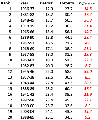
All your top 5 winters were incredibly warm in Toronto too, with the only exception being January 1966. We had a big storm in Jan 1966 that dropped 16-20", more than your entire season, wow! Seems like we got really lucky in those winters due to marginal snow events, sort of like last winter.
Another thing that stands out is; Detroit doesn't do well in El Nino's or neutral ENSO winters. Of your top 10; 5 were El Nino, 1 La Nina, and 4 Neutral. And that rule is more or less applicable for us in Toronto too. Though some El Nino's can be quite good (2002-03, 2004-05, or 2018-19 to name a few). I would think the inverse is true for your top 20.
-
1
-
-
4 hours ago, mississaugasnow said:
Theres a big cluster of around 27-31" in the 6-10 least snowy winters for Toronto.
Not trying to cherry pick data as its the easiest right now to grab but from 2013 to 2023 (11 seasons) Toronto had 6 Aprils record under 1" 2 Aprils record 1-2" 3 Aprils record 3-8" (2016 was 8")
April always sees snow but it's mostly under 2". Still counts towards the yearly snowfall no doubt but the odds are heavily against anything more than a coating
Yeah I agree. 52-53, 06-07, 09-10, and 11-12 were unusually low and snowless winters. Almost anomalous when considering the other top 6. I hate to group 09-10 in there, even though stats say otherwise, cause that winter was just bad luck/timing for us in Toronto. Many places south and north of us did decent that winter.
That big cluster includes 15-16 and 01-02. 15-16 got saved by that April snowstorm and 01-02 got saved by that late January storm that dropped 8". Both were incredibly warm.
Some other historically bad winters include 1932-33 where only 25.7" fell. And 1936-37 was pretty bad too. Only 13" fell between DJF combined. 1937-38 was bad too.
You're right about April snow. Big April snow is rare. Since 2005 (the last snowy April), we've only had two respectable snow events in April (2016 and 2022). 2018 was that ice pellet storm that dropped 4".
-
2 hours ago, michsnowfreak said:
Very doable for Toronto. Although far from a lock. If Detroit saw not one flake the rest of the way (impossible lol), it would be the 7th least snowy winter. To avoid top 10, just 1.8" more is needed and to avoid top 20, 8.9" more is needed.
Much like this stretch of deep winter we are coming out of, should there indeed be a sharp reversal from warmth to cold as we head towards mid-Feb, that still does not sort out the haves and have nots of snowstorms until we are closer in.
What are the top 10 least snowiest winters in Detroit?
-
3 hours ago, mississaugasnow said:
Wow you've seen a lot. Toronto has only seen 8" in the last two weeks. But you're very optimistic when it comes to snow season haha. It can snow in April as we've discussed a bunch but you tend to act like its a full winter month lol
YYZ at 14" as of yesterday. About 3" away from 2011-12 and 7" away from the next lowest seasons (09-10 and 52-53). They got lucky with the clipper snow this past week but nothing special. The two big storms we saw earlier in the month were both primarily rain followed by a 7-8 day cold shot, which for the most part, wasn't really exceptional, even by Detroit standards where they've experienced far worse (i.e., Jan 2022, Jan 2019, or early Jan 2018). Now back to the warmth this week and next which has become a common theme in the last 4/5 winters.
Not a fan of April snow. Let's take Detroit for an example. The average high by early April is around 50F or higher. That's almost 20 degrees above freezing. Any snow that falls will melt within a few days max and snow ratios suck.
-
3 hours ago, mississaugasnow said:
Yep, biggest storm of the year here at my place. 3" with 5" on the ground. Temp has risen to 33F though
That's great. We're getting heavier snow now. Been on and off throughout the day but close to 2" so far.
-
The potential storm around the 28/29 is starting to look intriguing. Both the GFS/ECMWF have something interesting. CMC doesn't quite wrap the storm up like the former.
-
4 hours ago, bluewave said:
Even in this new era of warmth extremes, what is showing up to start February is way beyond what we have ever seen during an El Niño February. The highly amplified MJO over the WPAC is flipping the script. This would be extreme for December let alone in February when El Niño’s are supposed to be cold. Ridiculous how far into Canada the above freezing line gets pushed.


Quite the extreme flips across Canada. From historic warmth in Dec to an historic cold outbreak last week to historic warmth next week lol.
Although Calgary can experience chinooks, they could hit the low 60s by next week (which is unusual). Regina, SK, more closer to the Plains/Midwest, is well above freezing by next week. Historic warmth across the west. A lot of extremes over the last couple of years.
https://weather.gc.ca/city/pages/ab-52_metric_e.html
https://weather.gc.ca/city/pages/sk-32_metric_e.html
The massive ridge doesn't help the drought situation across the Canadian Prairies and could also mean another big wildfire season and more smoke days for all of us out east.
-
5
-
-
2 hours ago, OrdIowPitMsp said:
Looks pretty typical for the lower arctic to me.
Cold near the edge of NWT, near Beaufort, means nothing to us. It's cold this week because the PV has moved back up north, but I think by early Feb the models move it back to the Arctic.
-
Looking good for 2-3", locally 4", across most of the GTA away from the lake, assuming temperatures can stay around the freezing mark or below. @mississaugasnow
-
21 hours ago, mississaugasnow said:
Ya, this period of cold and every other day light snow of 0.5" where I live has probably saved this from being an F winter.
I have about 3" on the ground now, river frozen, and another 1-4" system plus freezing rain coming Tuesday.
Averages are bottoming out right now at 30F for a high and quickly gain 6F to 36F in 5 weeks.
YYZ is still running a good 3C above average for Jan and next week's warmth will seal the deal for another warm January. Of the last 5 January's since 2019, only 2022 was below average lol. A one week long cold shot with no storm isn't going to change this winters grade from being an F - in my books. This cold shot has been nothing speculator either.
Hoping February is better, but it's looking to start warm.
-
 1
1
-
-
Extended GFS looking warm after early next week with mostly rain threats except maybe early next week due to the lingering cold HP in Quebec.
Chances of a futilty winter keep going up with each passing day. A wasted week of cold. @mississaugasnow
-
1
-
-
32 minutes ago, michsnowfreak said:
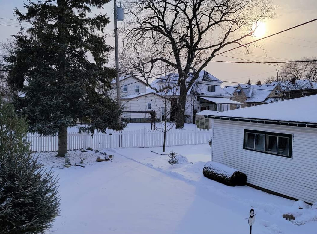
0.6" of sugar snow fell overnight, and the Arctic looking sun this morning made for a beautiful winter morning. January snowfall today is 9.2" at DTW and 8.9" imby.
A picture perfect day for a snow lover like you.
")
-
1
-
-
3 minutes ago, mississaugasnow said:
Ya, YYZ has been questionable throughout its history.
EC should have more official sites around GTA.
You're right. And they did long ago but massive budget cuts have led to limited stations now lol. And if you're going to cut back on stations, then at least improve the way you record data at the existing ones.

-
1
-
-
26 minutes ago, mississaugasnow said:
The actual downtown of Toronto sees a similar climate to Toronto Island. So even using YYZ skews it higher for those in DT-Mimico-Port Credit-Oakville-Burlington
If YYZ reports a lot less compared to the Island then I might start to think somethings wrong. But the way airports measure and where they are located has always been a thorn in the side of the weather community lol.
Look at Buffalo airport. Its NE and doesnt represent the City or southern part that well in lake effect. Nor does it represent the temperature in spring and fall
You do have a good point but for a long time while the "Toronto" station was operational, it was usually recording more than YYZ. And that "Toronto" station was in downtown near University of Toronto, if i recall, based on what another poster here was saying. It's been recording data since 1840.
I'll give you an example. That Toronto station recorded an astounding 84" during the 1959-60 winter vs 55" at YYZ. That 84" is a random winter that nobody has ever talked about, but it recorded more snow than the official snowiest winter at YYZ (1938-39) lol.
Based on that alone, YYZ has always been questionable. Buffalo's differences might be attributed primarily to lake effect as LES is always localized. Plus, unlike EC, NWS has like 10 stations per city lol.
Temperatures I do agree with and thats because of the urban heat island effect which is more profound in rural vs urban areas.
-
1
-
-
14 minutes ago, mississaugasnow said:
Interesting data. I think EC is right off the hwy about 5km east of the airport so that could be the cause of a bit of it.
The size of GTA means it's going to be difficult to get a good representation of the city. Everyone south of QEW-Gardiner has a much different climate. They all got nearly nothing and had no snow on the ground until today. Next zone is QEW-401 and then 401-407 and 407 north.
I do agree. Areas much closer to the lake tend to be warmer and less snowier than areas further inland. This winter is a good example of that. However, mathematically speaking, YYZ and EC's headquarters are almost on the same plane. Both stations experience similar temperature's when it snows but vary during non-precip days.
I'm not sure if YYZ still uses the nipher because the differences have substantially improved and almost netted out to near zero over the last 6 years but man, 2004-2014 was really bad lol. I know for a fact 07-08 was unofficially the snowiest winter ever recorded at YYZ, but they lowballed the Mar 08 storm quite a bit. YYZ only recorded 6" whereas every station in the GTA recorded 13"+. Hence why North York has averaged around 51" over the last 29 years, which I feel represents many areas quite well around the 401 and north towards Vaughan minus northern regions of Vaughan like Maple, Teston, etc.
-
1
-
-
21 hours ago, mississaugasnow said:
I agree. The only plus side is it will finally feel like winter for 10 days. This might be the best stretch of winter for consistent snow cover.
I agree. The first time since 2022 where it's felt and looked like winter for an extended period of time.
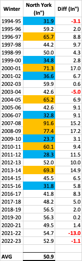
I was bored so I looked at the total snow accumulations at North York (where EC is headquartered). North York began recording data in Nov 1994. I compared it to YYZ to see the differences in amounts. Let's just say YYZ is an actual joke and this whole "nipher" thing needs to be abolished. The ones in red font below are where YYZ recorded more snow than North York. The ones highlighted in blue are the exceptionally below normal winters and the ones in orange are the exceptionally snowy ones. Winters like 2000-01, 2007-08, 2008-09, and 2013-14 stand out like sore thumbs. Consequently, North York has averaged 50.9" over the last 29 winters vs. 45.2" at YYZ.
Edit: Fixed the "winter column".
-
Got an inch today from the disturbance impacting the east coast. Gave it a nice wintry feeling with 4" on the ground now.
-
1
-
-
11 minutes ago, frostfern said:
I don’t think interior BC gets 80 degree dewpoints though. I have experienced some PNW heatwaves, and they can be very hot and also humid enough to be uncomfortable, but you never get that steamy tropical feel. It also seems like the most extreme temperatures happen in localized downslope areas. I noticed Olympia Washington hit 110 while Seattle only got to 101. It has something to do with the terrain. There are plenty of extreme places on earth, especially when you consider micro-climates, but the combo of tropical summers and brutal cold winters seems kinda unique to the Midwest US IMO.
Nope they didn't, you're right. Dewpoints were in the low 50's. Most of the heat they experience in the PNW is dry, desert like heat. Quite different than the heat we experience in the Midwest and GL's. The lakes, especially if they're ice-free or have very little ice, regulate a lot of the temperatures we experience in the winter. It's even more prevalent in areas adjacent to the lakes. Otherwise our climo would probably be similar to the Midwest imo.
-
4 minutes ago, Lightning said:
I will gladly admit to being a sicko then!!
 I don't mind below zero weather (likely because I do winter sports). Having the right clothing is everything. Was outside for several hours yesterday. Walked the dog 5 miles this morning. Not about to move Fairbanks as I love our humid summers here. But if had to choose between Las Vegas, Phoenix or Fairbanks; easy choice Fairbanks hands down!!
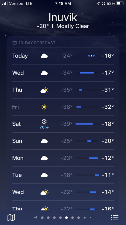
Time you move to Yellowknife. Here's their forecast for the next 7 days. Every single night for the last 7 days has been below -40F.
-
1
-
 1
1
-
 2
2
-
-
13 minutes ago, frostfern said:
Most other places in the world that experience extreme seasonal variation are more arid. The upper Mississippi Valley is kind of unique in how tropical it can get in the summer while still having very harsh winters. I think the only other place similar is the northeastern part of China. I think China is a bit more mountainous though and mountains will shelter some areas. There is no real mountain range anywhere separating the arctic and Siberia from the Midwest US. Same for humidity from the Gulf / Caribbean.
I beg to differ. Parts of interior BC got up to 120F during the 2021 heatwave, shattering all time records. And BC is practically all mountains except the immediate coastline. However, I believe mountains can definitely play a larger role when it comes to precipitation. That's evident in BC where Burnaby (near Vancouver) averages 79" per year whereas Kamloops, 4 hours inland, averages only 11".
-
1
-
-
Total snoozefest next 8-10 days. And that'll pretty much take us until the end of January. Finally got some cold air and the storm production shuts off.
I'd say the pattern change was a semi-fail. We got two big storms in less than a week with nearly identical tracks but there was no cold air around for any substantial snow for most of us (minus parts of Michigan, Iowa, and Illinois). Kinda sucks. Hoping the last few days of the month, despite a potential warm-up, or February play out better.
-
1
-
-
7 hours ago, mississaugasnow said:
Did any snow make it thru the night? My parents on the lakeshore have nothing and mostly saw a mix with only a little bit of snow
Yeah I still got a solid 3". I was at YYZ today to pick a friend up and there's about 2" on the ground there too.
-
1
-
-
Had 4.2" with that initial banding before it switched over to rain. YYZ recorded 2".


Winter 2023/24 Medium/Long Range Discussion
in Lakes/Ohio Valley
Posted
Statistically speaking, every winter month (DJF) except Feb 2021, and Jan/Feb 2022 has finished above average (temperature wise) since 2019-20. That's an ugly stat. It's even uglier if you go back to 2015-16. Only 4 more months (Jan 2019, Jan 2018, Dec 2017, and Dec 2016).
More like light snow events that in some winters would be considered average (i.e., ~2"). And the next 10 days look warm and snowless.
If we want to specifically filter out for strong Nino's, then January 1992, January 1988, and February 1973 had more impressive cold outbreaks. January 1966 was probably the more impressive one because the month finished below average.