SBUWX23
-
Posts
1,292 -
Joined
-
Last visited
Content Type
Profiles
Blogs
Forums
American Weather
Media Demo
Store
Gallery
Everything posted by SBUWX23
-
Yep snow habit plays a key role in ratio. Cold is just one factor.
-
What do you expect them to do when guidance is spread
-
I'm seeing a lot of 30-32. I'd wanna see temps in the 20s for higher ratio.
-
Be careful with just expecting high ratio snow. Yes it's colder aloft but surface temps are still not as cold as I feel needed for higher ratio. Id temper it a bit and say more 10-12:1
-
This obviously includes snow from tomorrow night north of our area
-
2/13 Significant/Major Winter Storm Discussion & Observations
SBUWX23 replied to Northof78's topic in New York City Metro
I know people around Islip. 4.3 seems right. -
Gefs probs are not too shabby for greater than an inch. Temper expectations.

-
2/13 Significant/Major Winter Storm Discussion & Observations
SBUWX23 replied to Northof78's topic in New York City Metro
If we had been in the 20s that would not have happened. It's impressive enough that we had the cooling we did without the nice high to our north. -
2/13 Significant/Major Winter Storm Discussion & Observations
SBUWX23 replied to Northof78's topic in New York City Metro
The liquid equivalent out here was impressive in the 12-18z timeframe. Even here where it was 32-33, the temps and compaction were real. Probably would have had closer to 10 if not more but I'll settle with the half foot. Still a nice event. -
2/13 Significant/Major Winter Storm Discussion & Observations
SBUWX23 replied to Northof78's topic in New York City Metro
Good job sticking to your guns. The north idea was not a bad way to go given the overall crappy setup, but we were saved by several minor subtleties that played in our favor. Thankfully the upper low existed over southeast Canada. It helped keep things from cutting to our west and then obviously the positive tilt to the southern stream initially. The trialing system also help shunt it east. If things were timed 6 hours later I'd suspect amounts would have been lower because of the marginal temps and time of day. -
2/13 Significant/Major Winter Storm Discussion & Observations
SBUWX23 replied to Northof78's topic in New York City Metro
Live your lives and stop fretting over the snow at the park. It is consistent with LGA and not far off from other official measurements. -
2/13 Significant/Major Winter Storm Discussion & Observations
SBUWX23 replied to Northof78's topic in New York City Metro
there is deformation banding to the west of the city that has to pivot through. enjoy the snow and stop panicking over minor nuances. look what happened to our NW, obviously the deformation zone has good rates too. -
2/13 Significant/Major Winter Storm Discussion & Observations
SBUWX23 replied to Northof78's topic in New York City Metro
no this is not true. look at KDIX radar. there is a pivot south of the city. KOKX is missing some of the returns out that way. -
2/13 Significant/Major Winter Storm Discussion & Observations
SBUWX23 replied to Northof78's topic in New York City Metro
um returns are fine, look at KDIX -
2/13 Significant/Major Winter Storm Discussion & Observations
SBUWX23 replied to Northof78's topic in New York City Metro
If there posts how hrrr lowers rates soon, look at whats going on across the interior in Lohud and CT. Obs over model now. -
2/13 Significant/Major Winter Storm Discussion & Observations
SBUWX23 replied to Northof78's topic in New York City Metro
Some of that is bright banding where radar is seeing some mixed precip at beam height but yes good returns for the metro coming in -
2/13 Significant/Major Winter Storm Discussion & Observations
SBUWX23 replied to Northof78's topic in New York City Metro
Just needed heavier precip. -
2/13 Significant/Major Winter Storm Discussion & Observations
SBUWX23 replied to Northof78's topic in New York City Metro
Snow mixing in now with some sleet towards Yaphank area Suffolk county -
2/13 Significant/Major Winter Storm Discussion & Observations
SBUWX23 replied to Northof78's topic in New York City Metro

-
2/13 Significant/Major Winter Storm Discussion & Observations
SBUWX23 replied to Northof78's topic in New York City Metro
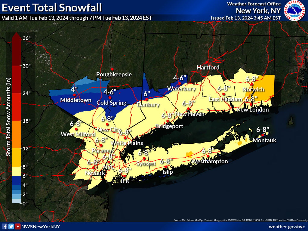
Make sure to check the event total graphics on NWS sites. Those include snow for the whole event the most likely starts at 12z so it's the remainder of event -
2/13 Significant/Major Winter Storm Discussion & Observations
SBUWX23 replied to Northof78's topic in New York City Metro
3km nam profile over nyc at 14z. I disagree there is a trend for weaker lift in NYC area.thumb.png.7a6cb96ed533e214318ac3cbf8cbcfb7.png)
-
2/13 Significant/Major Winter Storm Discussion & Observations
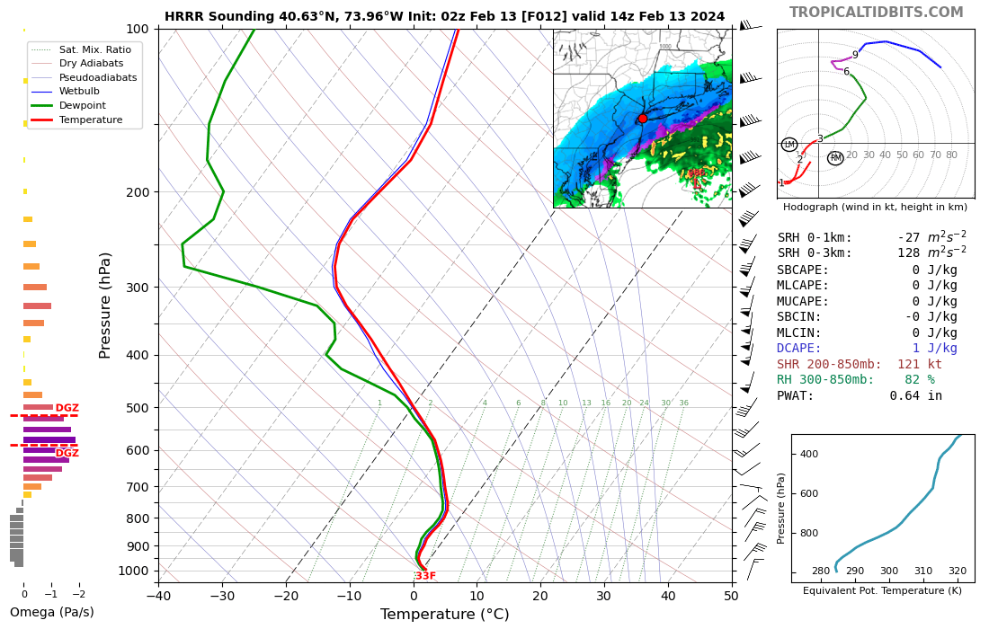
SBUWX23 replied to Northof78's topic in New York City Metro
Here is an example on latest hrrr at 14z
-
2/13 Significant/Major Winter Storm Discussion & Observations
SBUWX23 replied to Northof78's topic in New York City Metro
Respect him but that's at 12z. Lift goes up after that over the city -
2/13 Significant/Major Winter Storm Discussion & Observations
SBUWX23 replied to Northof78's topic in New York City Metro
Sun gonna be shining there tomorrow? -
2/13 Significant/Major Winter Storm Discussion & Observations
SBUWX23 replied to Northof78's topic in New York City Metro
Recon is sampling along the east coast as we speak.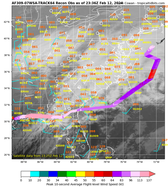


.png.14863b1813a21fab60d994acaa60d330.png)