oconeexman
-
Posts
2,048 -
Joined
-
Last visited
Content Type
Profiles
Blogs
Forums
American Weather
Media Demo
Store
Gallery
Everything posted by oconeexman
-
The “I bring the mojo” Jan 30-Feb 1 potential winter storm
oconeexman replied to lilj4425's topic in Southeastern States
How u doing over her blue turd? I hope you get a foot!! -
What's up peeps? It's about all you can ask for these days is to have one operational model giving a paste job and all the ensembles showing at least some snow falling board wide. Has potential for a nice little event!
-
Yea if we can get 3-4" of snow for me to watch fall, it can slett all it wants after. I'd be as happy as a pig in shiii!
-
Id like to think imby there won't be a lot of mixing issues during the last half but todays trends have me thinking it def will. Still time to reverse the trend and we got happy hour Nam this afternoon
-
I'm here Lil turd! Trying to temper expectations..liking a solid 2-4 then sleet to pound it down!
-
Mid to Long Range Discussion ~ 2022
oconeexman replied to buckeyefan1's topic in Southeastern States
Icon coming in colder but still a little too warm. But we know the warm bias it has esp in a CAD situation. Gonna be some model watching fun over the next week at least Sent from my SM-G986U using Tapatalk -
January 20-22 “bring the mojo” winter storm threat
oconeexman replied to lilj4425's topic in Southeastern States
Yes I had resided to maybe some flurries and I'd be ok with that. Still have snow in parts of my yard even after the rain. But now I'm thinking a solid dusting up here is a real possibility. Nonetheless almost the whole state will see winter weather...thats pretty dam cool! -
Winter Storm Izzy Obs Thread
oconeexman replied to Prismshine Productions's topic in Southeastern States
Finally all snow!! -
Winter Storm Izzy Obs Thread
oconeexman replied to Prismshine Productions's topic in Southeastern States
Blue turd for the win! Congrats -
Winter Storm Izzy Obs Thread
oconeexman replied to Prismshine Productions's topic in Southeastern States
Painful watching this rain/snow not being all snow! Temp finally dropping 35 -
Winter Storm Izzy Obs Thread
oconeexman replied to Prismshine Productions's topic in Southeastern States
Told u this one is gonna be good for you! Congrats -
Winter Storm Izzy Obs Thread
oconeexman replied to Prismshine Productions's topic in Southeastern States
Full on mix now..moderate -
Winter Storm Izzy Obs Thread
oconeexman replied to Prismshine Productions's topic in Southeastern States
Light rain/snow mix -
Winter Storm Izzy Obs Thread
oconeexman replied to Prismshine Productions's topic in Southeastern States
Light snow here..baby flakes 36/31 -
Winter Storm Izzy Obs Thread
oconeexman replied to Prismshine Productions's topic in Southeastern States
-
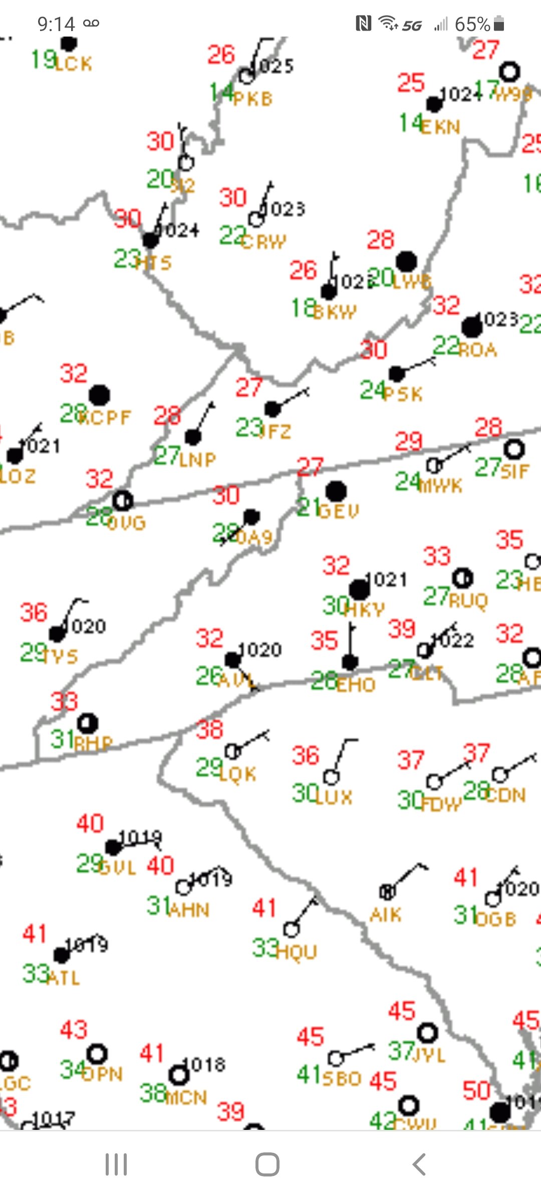
My sentiment exactly. Up to 39 with thick cloud deck and stout ne breeze. Obvious cad rolling in at the perfect time.
-
Incoming wedge

-
-
36/31 ene8-10mph
-
2021-2022 Fall/Winter Mountains Thread
oconeexman replied to BlueRidgeFolklore's topic in Southeastern States
-
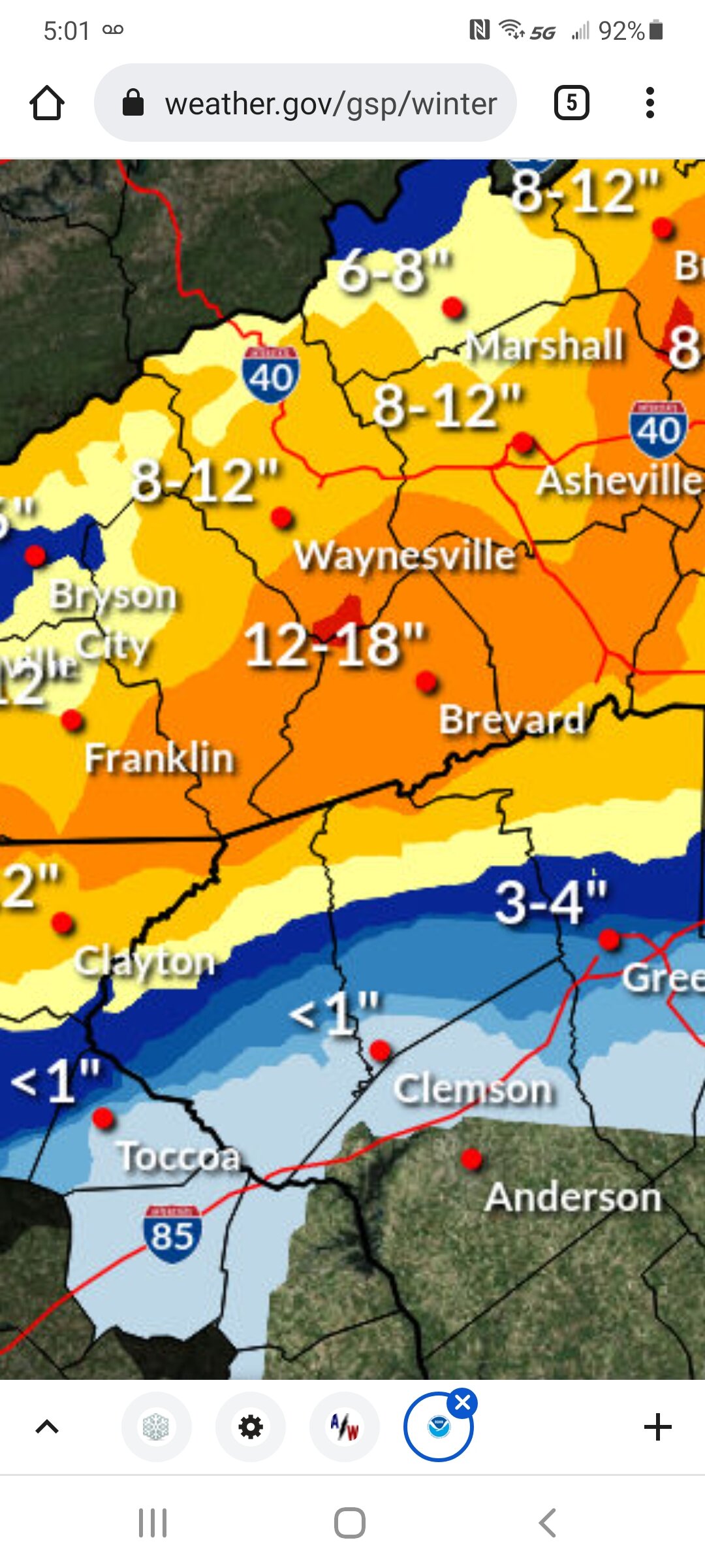
They did this last time I got 4+"..lol
-
Gsp on que drops totals here after warning.
-
2021-2022 Fall/Winter Mountains Thread
oconeexman replied to BlueRidgeFolklore's topic in Southeastern States
Let's see what the 12z nam does here. I expect some minor changes. -
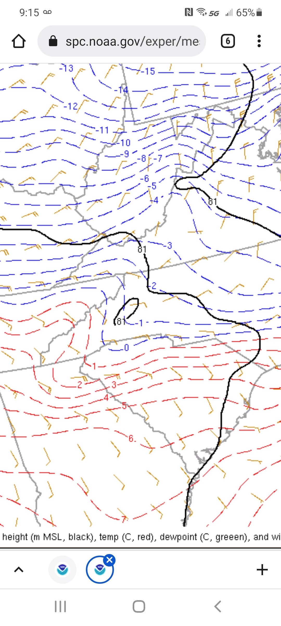
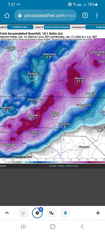
As the euro has steadily forecasted extreme upstate and extreme ne ga are in for a major here. Sw Nc will get pummeled for sure. Still time for adjustments and they will impact alot of folks good and bad. The latest trend is important imo of a south jog of the primary and track. Looking forward to today's changes!
-
2021-2022 Fall/Winter Mountains Thread
oconeexman replied to BlueRidgeFolklore's topic in Southeastern States
I thought that's what I saw. I'm all in so far...we may fail in the end but I'm still pumped for our area. I get the changeover is more likely to occur but if I can watch that much snow fall and accumulate I'd be perfectly fine.