forkyfork
-
Posts
30,804 -
Joined
-
Last visited
Content Type
Profiles
Blogs
Forums
American Weather
Media Demo
Store
Gallery
Everything posted by forkyfork
-

July 2025 Discussion-OBS - seasonable summer variability
forkyfork replied to wdrag's topic in New York City Metro
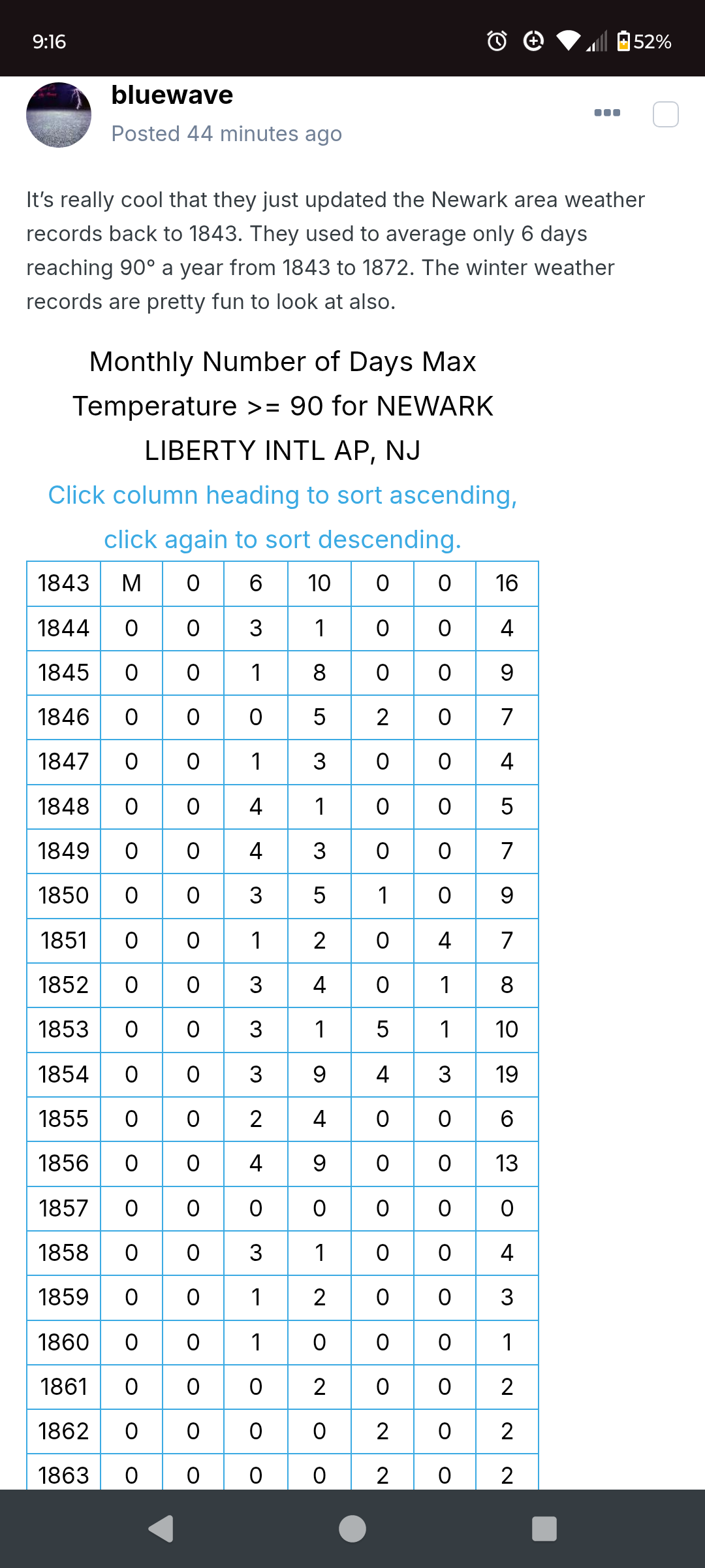
the winter of 1859 was brutally cold even for 1800s winters -
July 2025 Discussion-OBS - seasonable summer variability
forkyfork replied to wdrag's topic in New York City Metro
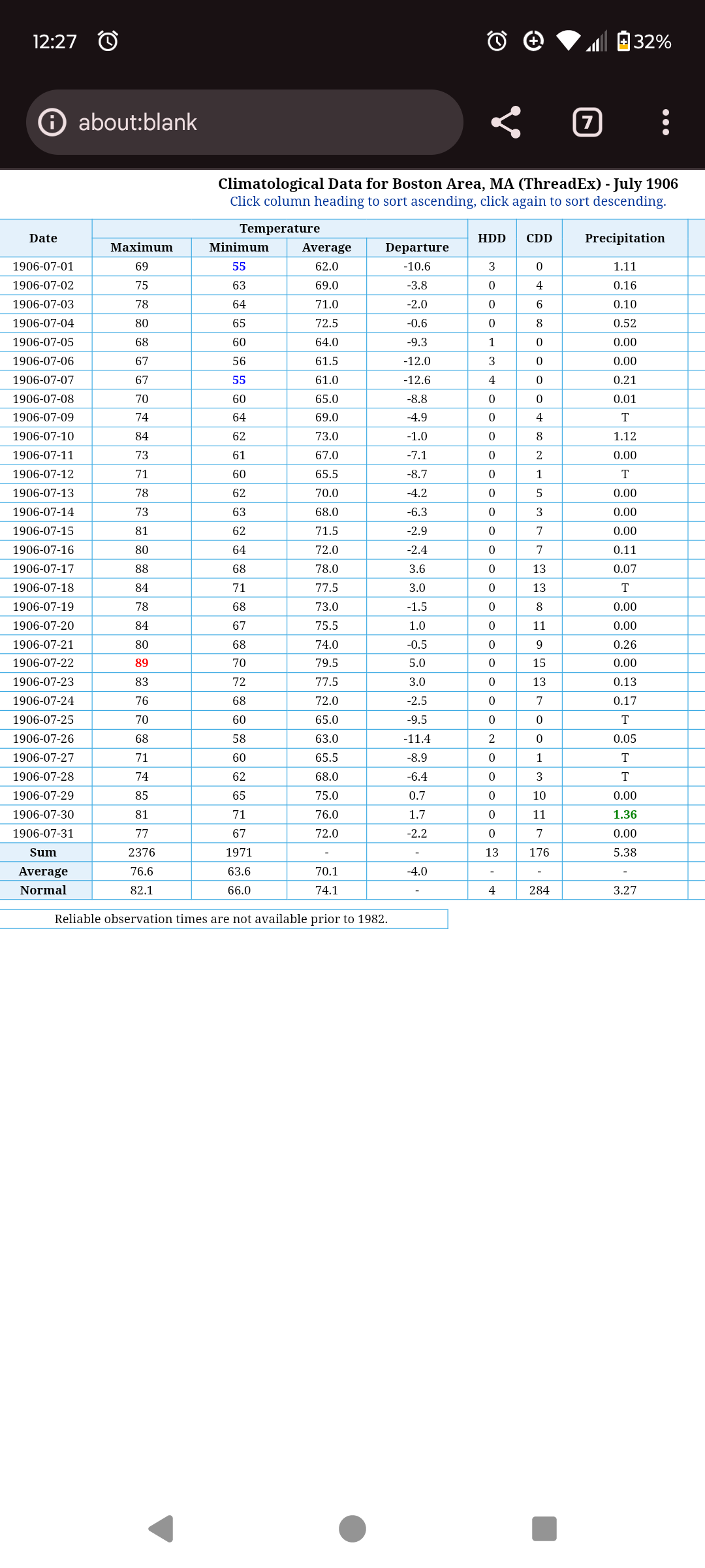
it's from a different downtown station -
July 2025 Obs/Disco ... possible historic month for heat
forkyfork replied to Typhoon Tip's topic in New England
ewr averages like 30 now, lol
-
i don't think the amo is a real thing
-
July 2025 Obs/Disco ... possible historic month for heat
forkyfork replied to Typhoon Tip's topic in New England
the third sentence is heavily influencing the first -
July 2025 Obs/Disco ... possible historic month for heat
forkyfork replied to Typhoon Tip's topic in New England
imagine if this happened again
-
July 2025 Obs/Disco ... possible historic month for heat
forkyfork replied to Typhoon Tip's topic in New England
events like this are dead https://www.spc.noaa.gov/exper/archive/event.php?date=20000602 -
July 2025 Obs/Disco ... possible historic month for heat
forkyfork replied to Typhoon Tip's topic in New England
we had a chance in june but we got a weird flash flood blob instead of a derecho -
July 2025 Obs/Disco ... possible historic month for heat
forkyfork replied to Typhoon Tip's topic in New England
it doesn't feel like fall it feels like a summer from the past -
i hate this weather because it brings out all the slow walkers
-
July 2025 Discussion-OBS - seasonable summer variability
forkyfork replied to wdrag's topic in New York City Metro
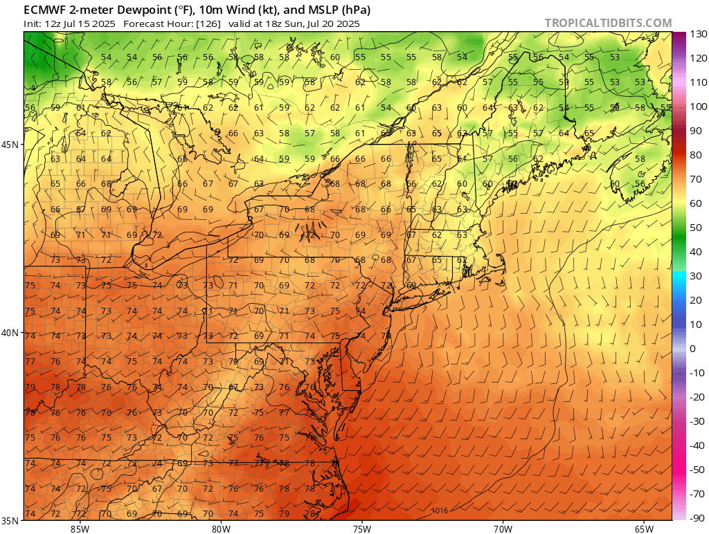
happy moisture return day to those who celebrate -
July 2025 Discussion-OBS - seasonable summer variability
forkyfork replied to wdrag's topic in New York City Metro
the trend is your friend
-
July 2025 Obs/Disco ... possible historic month for heat
forkyfork replied to Typhoon Tip's topic in New England
what would climate changed oct 2007 look like -
July 2025 Obs/Disco ... possible historic month for heat
forkyfork replied to Typhoon Tip's topic in New England
what is this guy on -
do any of you guys need diet/exercise help? a lot of you seem very unfit for these conditions
-
July 2025 Discussion-OBS - seasonable summer variability
forkyfork replied to wdrag's topic in New York City Metro
sun breaking out, ez 95+ for most -
so a typical january day around here
-
July 2025 Discussion-OBS - seasonable summer variability
forkyfork replied to wdrag's topic in New York City Metro
that's because it's full of low info snow voters -
all the worst people are miserable today <3
-
July 2025 Discussion-OBS - seasonable summer variability
forkyfork replied to wdrag's topic in New York City Metro
what a beautiful summer morning -
July 2025 Discussion-OBS - seasonable summer variability
forkyfork replied to wdrag's topic in New York City Metro
keep hope alive -
July 2025 Discussion-OBS - seasonable summer variability
forkyfork replied to wdrag's topic in New York City Metro

-
are we doing this again tomorrow?
-
3.5 months to go
-
i planted seeds today lol