LVblizzard
-
Posts
4,892 -
Joined
-
Last visited
Content Type
Profiles
Blogs
Forums
American Weather
Media Demo
Store
Gallery
Everything posted by LVblizzard
-
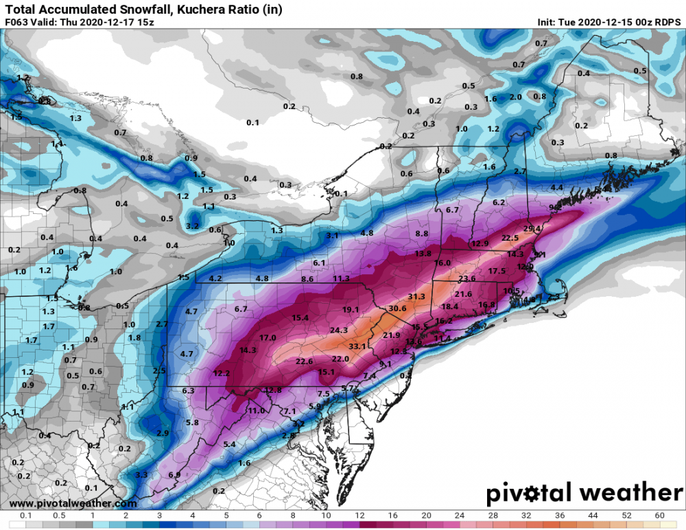
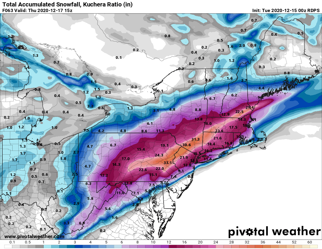
Everybody wins on the Euro! Solid foot or so for most of us. And there is potential for it to be even more epic too.
-
It all depends on how much energy swings around the base of the trough. If there’s a lot, the low tucks into the coast and that CCB does form. If the energy is just loose and all over the place, the initial thump may be nice but Monday and Tuesday’s snow will be pretty light for the most part as the ULL swings through.
-
Seems like this isn’t the storm for those hoping for 2-3”/hr rates and thundersnow...but if you like steady light to moderate snow for days, you’ll love this storm.
-
January 25-27 Light Wintry but Long Duration Event obs
LVblizzard replied to ChescoWx's topic in Philadelphia Region
A coating of snow and sleet remains in the Lehigh Valley tonight. Probably gonna melt tomorrow. -
GFS snows for over two days straight here. Mother of God!!!
-
GFS thermals are useless. If there’s a huge CCB like that it will most likely be snow.
-
January 25-27 Light Wintry but Long Duration Event obs
LVblizzard replied to ChescoWx's topic in Philadelphia Region
Snow/sleet mix in Bath. Huge flakes. We have a dusting on the ground already. -
Looks like this is becoming a serious threat with decent model agreement. Could be a long-duration storm too, tonight’s CMC shows nearly 2 days straight of precip from Sunday night to Tuesday afternoon.
-
Finally changing back to snow in Allentown.
-
It should change over very shortly.
-
Heavy sleet in Allentown but the snow line is minutes away looking at the radar.
-
Looks like the sleet line is starting to slow significantly as it approaches Allentown.
-
Ripping like crazy here in Bath. Near blizzard conditions.
-
Not with a 2”/hr rate like some of the models have been showing.
-
Moderate snow in Bath, PA. Heavy stuff looks to be right on my doorstep. Hoping for at least 4 hours before sleet.
-
First flakes in Bath, about 5 miles north of Bethlehem.
-
Made my final call for the Lehigh Valley on my page which is 8-14”. When the snow falls, it’ll fall hard, but I see sleet and a dry slot screwing things up here for a few hours in the evening.
-
The HRRR and some of the other hi-res 12z models think the NAM is completely out to lunch, they’re holding to their colder solutions. Gonna be interesting to see how this plays out this evening.
-
Ah good catch. That’s definitely more reasonable.
-
I’ll permanently delete my account if Doylestown hits 16”
-
Here’s my guess for accumulations: Philly: 3-6” Trenton: 4-8” Lancaster: 8-14” Doylestown: 6-10” Harrisburg: 12-18” Allentown: 8-14”
-
Euro sucks except if you’re in the Poconos.
-
The Stella flashbacks are real here. At least the trend is happening 36 hours prior rather than 24 so forecasters have time to change their forecasts.
-
Sleet is even getting up to the Lehigh Valley on most models now. Ugh. I’m going with 6-10” from the front end thump here, then some sleet, then 2-4” more from the CCB. 8-14” sounds good but it’s disappointing when just 12 hours ago the consensus was for 1 1/2 feet with no mixing.
-
RGEM nukes the Lehigh Valley into oblivion