

LongBeachSurfFreak
-
Posts
8,491 -
Joined
-
Last visited
Content Type
Profiles
Blogs
Forums
American Weather
Media Demo
Store
Gallery
Posts posted by LongBeachSurfFreak
-
-
1 hour ago, Ginx snewx said:
Long fetch of Strong sse winds with high ASTRO tides. Barriers also damaged 12 /18
Exactly. It’s the extremely long fetch. Which builds wave periods above 14 seconds. Something usually only seen on the west coast. The next storm is going to cause big erosion issues. On par with 10/91 and 12/92
-
9 hours ago, jm1220 said:
All the storms over the last 10-15 years knocked all the weak trees down. In Long Beach, all number of powerful storms especially Sandy knocked every tall tree down and everything is new or smaller, and some of those were knocked over but those thankfully don’t topple the power lines with them. As for Friday it looks like a weaker version of yesterday’s storm but of course any rain is beyond unwelcome and will raise the river levels again just as they recede from crest. This is the stormiest winter I can remember so far which you would expect in a strong Nino but it seems especially severe. Hopefully we can time cold air with one or two of these and they can take a good track. Cutters like these are definitely unusual in a strong Nino.
Check out the beaches, it’s getting really really bad. These storms have these huge Se fetch components. Which build enormous high period swells. This next storm could be the knock out blow for allot of places, especially fire island.
-
 1
1
-
-
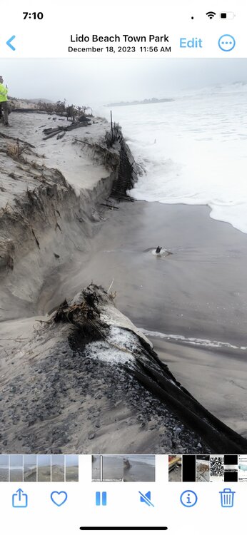
Just monumentally bad beach erosion today.
-
 3
3
-
-
Very very severe beach erosion from what friends are telling me. Our life guard shack at Jones beach didn’t flood during the last storm but now has feet of water. As soon as I leave work at 2 I’m headed to lido, Long Beach. It’s gotta be terrible there.
-
Watching all the Surfline premium cams currently as it’s high tide and my God the beaches are being destroyed. It’s another super long fetch event.
-
1
-
-
That line was nuts on the uws strongest winds since Isias
-
1
-
-
17 minutes ago, WestBabylonWeather said:
This is not good.
I’ll be there in two hours.
-
1 minute ago, uofmiami said:
It’s basically a super abrose jet event. This will sting.
-
 1
1
-
-
1 hour ago, Stormlover74 said:
We did not get off school in December 92. I remember walking through flooded streets with tree branches snapping all around to get to school (uphill of course)
Yeah, it was actually a legit emergency where I grew up. Busses couldn’t leave until the tide dropped and forget about parents in cars and station wagons in the days before SUVs. I remember being stuck for hours at mandalay elementary in wantagh as a 5th grader. Not to mention the winds were on par with sandy. That roar you never forget of hurricane force gusts.
-
1
-
-
57 minutes ago, wdrag said:
Suggest taking wind seriously from Cape May NJ to JFK eastward with 45-55 MPH NYC, but Cape May to southern LI 60 MPH + likely. best time s NJ near 7PM up to NYC -LI mid-3A. I think precautions are wise. I just posted the MINIMUM gust potential from an 8 member SPC High Res model. Its imperfect. I dont want to look at the worst but 75 MPH is not impossible on LI. Minimum: Purple is 60, dark brown 55, ;light brown 50 and this is a snapshot of wind gusts near 1AM.
The HRRR and SPC HREF gin gusts tend to be used. by firewater folks. High res data. Within 24 hours...need to pay attention. to this guidance.

That’s another monster fetch you just don’t see on the east coast. Major to extreme beach erosion is a lock, as tides are higher than the last event and this looks stronger.
-
1
-
-
21 minutes ago, jm1220 said:
Yep, really dynamic system coming. And very high PWAT/dew point air is coming in and as mentioned not much of an inversion. I’d be ready not to have power. With the pace of these storms there won’t be much of a beach left soon.
-
1
-
-
I was just looking at buoy obs from down south and wow, there have been some seriously strong winds for a winter storm down there. 64 knot gust just south of Alabama. Seas are also pushing 20’ in the gulf. I think this is a real wind threat this time.
-
2
-
-
14 minutes ago, weathermedic said:
From Upton:
The High Wind Warning has been expanded to include the Bronx and Manhattan from 6 PM tonight to 6 AM tomorrow. Southeast winds of 20 to 30 mph with gusts of 65 mph are expected inland, with 25 to 35 mph winds and gusts as high as 70 mph anticipated along the coast. The period of strongest winds will be from about 9 PM to 3 AM.
I’ll never forget being on the Long Beach boardwalk during March 10. Legit 70mph gusts will throw you around. I’m sure there was some intensity increase because of the buildings but it was unforgettable experience. Only other times I experienced winds of that magnitude were December 92 and of course sandy. I’m thinking more like 60mph here.
-
1
-
-
Just now, LongBeachSurfFreak said:
They haven’t done that well the last few years. You really need as much elevation as possible in our new climate. 1000’ used to be great, now it’s 2000’+. Which really cuts down options to the greens and whites. There isn’t much infrastructure above 2k in the Catskills or even Adirondacks. I guess the top of the Pocono plateau being above 2k can get it done, but they always seem to be to Far Sw in our current storm track.
Honestly I would love to see an obs station setup on top the Nordstrom tower on the flat roof at 1550’. Sunday, I could see even the 500’ new buildings on the uws completely obscured in heavy snow, while we had white rain at the surface. I would have to imagine, that roof scored 6” of more, similar to elevations similar in jersey.
-
On 1/5/2024 at 9:44 PM, jm1220 said:
I’d probably pick somewhere along the I-88 corridor, Cooperstown area maybe. They get some of everything-lake effect and can get slammed by synoptic storms. Also not too far from NYC.
They haven’t done that well the last few years. You really need as much elevation as possible in our new climate. 1000’ used to be great, now it’s 2000’+. Which really cuts down options to the greens and whites. There isn’t much infrastructure above 2k in the Catskills or even Adirondacks. I guess the top of the Pocono plateau being above 2k can get it done, but they always seem to be to Far Sw in our current storm track.
-
Just now, nycsnow said:
Similar swells as well 15-20 feet and I believe there was no astronomical high tide for last storm but this one there is
Exactly, I actually banged out of work for the event to shoot some video of the largest seas since sandy. Unfortunately the sea spray was so bad visibility was near zero, so all I got was the roar and the shore break. But the erosion was incredible. Waves smashing off the dunes.
-
1
-
-
50 minutes ago, nycsnow said:
The reasoning behind the high wind warning and wind advisory. The
main key feature is a low level jet maximum of near 100 kt that
develops this evening at a height of around 4-8 kft. Model sounding
BUFKIT profiles do not depict a strong inversion, as the thermal
profiles appear to be close to isothermal. Winds just 1-2kft above
the surface are shown to reach 50-60 kt across the coastal areas and
with the heavy rain and aforementioned thermal profiles, much of
this should get mixed down to the surface through downward momentum
transport. The timeframe for this generally after 02Z Wednesday and
before 09Z Wednesday for Western Long Island and New Haven CT west.
The timeframe for this to the east generally after 03Z Wednesday and
before 10Z Wednesday.

Also, coinciding with this timeframe will be tremendous increase
vertically with omega and the total southerly flow extending
throughout the troposphere will increase the PWATS to well above
90th percentile climatology values. Models still conveying PWAT
values near 1.4 inches maximum overnight into the coastal parts
of the region.
1.4” pwat in January is nuts. Someone’s going to be dealing with real deal river flooding where snow melt is also an issue.
also, for the coast another huge fetch building monster seas by east coast standards. More beach erosion and wash overs likely. The last storm made 8 foot cliffs at lido beach, expecting that to get worse.
-
3
-
-
So western
Long Island did best last nights. With I guess realistically, .5” there was a full coating on colder surfaces:
-
2
-
-
Large flakes uws, I would call it moderate.
-
Currently moderate accumulating Sleet on the uws.
-
Just now, LongBeachSurfFreak said:
Yeah it was some where between a half inch and an inch just south of the southern state in lynbrook, it was pouring when it ended and I couldn’t get an accurate measurement. I’m the last address north in lynbrook, so my apt often comes up as malverne
-
1
-
-
1 hour ago, wdrag said:
The WPC moderate risk for flooding Tuesday-Wednesday is attached issued about 07z/7. Someone ping me if I missed this post earlier in the morning.

Exactly, if you live at the bottom of any sort of hill, you wanted less snow. Tuesday is going to do Irene in New England level damage now
-
22 minutes ago, psv88 said:
Back to snow/sleet mix here as the CC line collapsed back south. She’s a fighter
That’s amazing, changed to rain here hours ago after about .75”.
-
1
-
-
2 minutes ago, Cfa said:
36 with light to occasionally moderate snow in Lake Grove, no accumulation. That “it’s gonna snow” feel outside a few hours before an event remains undefeated.
Wow, we have close To an inch on cold surfaces here, north lynbrook. Almost all rain now though


January 2024
in New York City Metro
Posted
Well at least you get to see snow now that you moved. What’s terrible stretch for the island. Hopefully our one shot at redemption next week.