-
Posts
9,330 -
Joined
-
Last visited
Content Type
Profiles
Blogs
Forums
American Weather
Media Demo
Store
Gallery
Posts posted by LongBeachSurfFreak
-
-
Imelda is going to be a mean bitch. Carribean cruiser, cat 5.
-
 1
1
-
-
4 minutes ago, Cholorob said:
This actually got me thinking a bit, I was reading an interesting article recently talking about how the Gulf Stream helps keep Europe warm and highlighting concerns about a weakening Gulf Stream. Conversely, I assume that if the Gulf Stream weakened significantly and ocean temperature were not made hotter as a result of other climatological changes, that this would actually reduce the number of very powerful storms hitting North America? Is the logic sound here?
.Yeah it’s fuels both hurricanes and the temperature differences that power nor’easters. Without the Gulf Stream the weather in the northeast would be much more mundane.
-
12 hours ago, WxWatcher007 said:
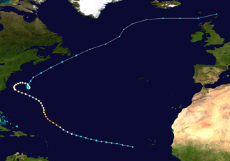
There's no doubt that Erin has left a substantial wake--even more than I originally anticipated, but I'm not sure the wake has reduced the threat to the U.S. much, if at all.
My analysis here is mostly based on location. Erin safely recurved between 70 and 75W. That's a location where many WNW and especially NW moving systems find their way getting kicked OTS. If a system is moving NW at 72W, it probably isn't going to be a threat to the U.S., especially given the current predominant steering pattern.
If this wake were between 75 and 80W however, it'd signal to me that a bona fide threat to the U.S., a system moving through the Bahamas and just off the southeast coast, or a system moving northward from the very warm central and western Caribbean, would find a hostile thermodynamic environment. As it stands though, something hugging the coast is still likely to find enough positive SST anomalies and OHC to be a significant system if other atmospheric factors are also favorable.
Let's say however that there is some hurricane that is moving westward or NW through that wake a month from now. A repeat of Florence for instance.
It would certainly run into problems given its intensity moving toward the coast, but on final approach, it would find a more favorable thermodynamic environment. That opens the door to what we've seen frequently in recent years--intensification in the hours before landfall. It's an entirely different story if that wake is hugging the coast.
Perhaps there is additional cooling given the current pattern, though I'd argue that it's hard to get a sense of where this area will stand in about a month, objectively the waters are still warm enough to be conducive, depending on the intensity of the hurricane.
So while for now at least we've probably avoided the worst case scenario along the east coast with certain tracks, we are nowhere close to eliminating other viable, bad, options. I just don't want people getting a false sense of security that Erin and this current upper level pattern will save us...as recent years have shown us we can be incredibly active even when environmental conditions suppress weeks of peak season. That is my expectation of this season as well.
Up here on Long Island Erin took the water temps from the high 70s to the high 60s temps recovered to the low 70s which is about normal for this time of year. Hurricanes in the north east derive their energy from the Gulf Stream and will weaken once above the north wall. It’s a function of the long shallow continental shelf.
-
 1
1
-
-
There’s no way 190 ace is happening with a lull right during peak season. A strong backend is still likely based on increased vertical instability but it’s going to be hard to make up for lost time. Erin also cooled a large portion of the typical recurve track which will limit future storm intensity in that region.
-
 3
3
-
 1
1
-
-
6 minutes ago, Brian5671 said:
I remember it too-was not well forecast but we had 50-65mph gusts under clear skies-interacting with a high pressure off to the west if I remember correctly-alot of tree limbs down..
Yeah, went from foggy and zero wind at 6am to blasting north wind (gusts 60+) by noon under deep blue skies. One of the more incredible weather days we have seen in our life times. I remember walking up the beach into sand blasting gusts and having to hold on to my board for dear life.
-
 1
1
-
-
21 minutes ago, ROOSTA said:
I'm more worried about the next.
Short term forecast for ERIN isn't even close to being accurate.
If this was my profession, I'd be very careful declaring A FISH.
The thrill (skill) is why and how? This we all know but the timing is off.
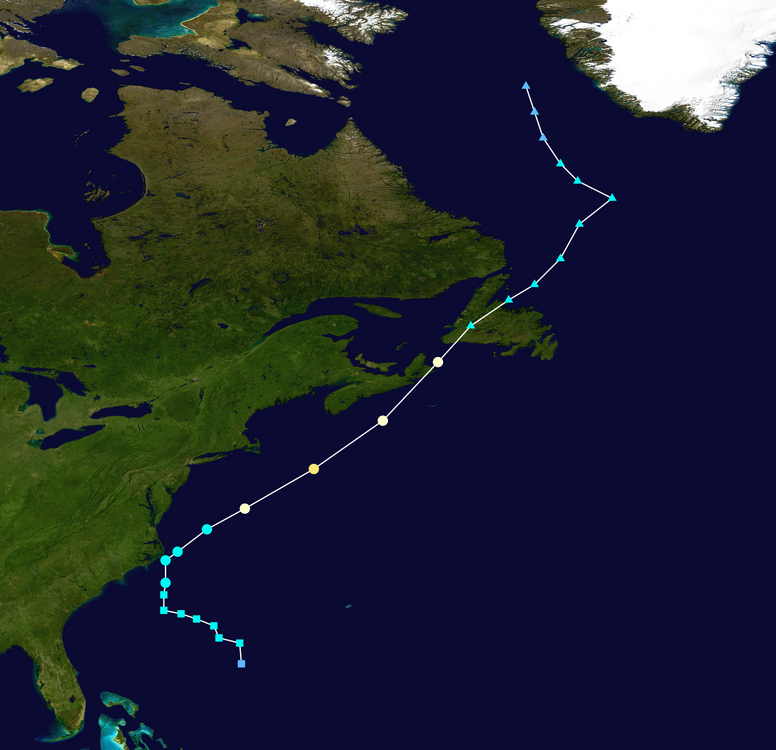
My memory is terrible, years and named storms. I recall a tropical entity that miss (3) troughs, looped a couple of times just off NC.Felix 1995
-
47 minutes ago, Damage In Tolland said:
This could “possibly” be like that deal we had in I think 2001. We had a strong offshore cane and strong HP to north and it created huge pressure gradient . There were HWW for all of SNE. I remember it distinctly. Was sunny/ cirrus but winds ripped during the day . I may not have year right, but I’ve talked about that event in here before
It was gustav September 11th 2002. I remember it so well because it produced the most epic barrels on Long Island I have ever seen. Until the winds went nuclear North at 50mph and blew the swell down.
-
 1
1
-
-
54 minutes ago, WxWatcher007 said:
Yeah, zero concern in the long range from me right now. As we saw with Erin, these long range model runs aren’t good for much..
Heading into peak with above normal water temps in all but the far east MDR anything is possible.
-
6 minutes ago, Dan76 said:
gets it to 914

Yeah that will rearrange some beaches, even without a landfall. I wonder if the models are keying in on some baroclinic fourcing. Wind field really expands so that would be the only way to maintain such ridiculously low pressures. (Obviously over modeled) Anything sub 940 north of 30 would be unprecedented in the modern era.
-
 2
2
-
-
41 minutes ago, Hoth said:
Bill's waves were the first time I understood the kind of power these storms pack. Just a special experience for me on Fishers Island. Massive massive waves slamming the beach and sucking thousands of stones out as they receded, all under a full moon with distant flashes of lightning on the southern horizon from the nearest band. My house is on the northern side of the island and you could hear the waves thudding a mile and change away.
That’s a great story. I always wondered if fishers island was surfable. Takes a serious swell to make it through block island sound. On the hurricane teddy swell a few years ago I could hear the boulders moving under the waves in Montauk. A very cool clunking sound. Surfed some 15’ waves at ditch plains that day.
-
 2
2
-
-
On 8/13/2025 at 6:37 PM, radarman said:
Big, big waves. Let's lock in an offshore breeze, TIA
This is a be careful what you wish for scenario. During the hurricane Bill swell in 09 almost every break on Long Island was washed out. As in, the waves were so big they started breaking so far out they just rolled through the break. Thursday looks to do just that. We do not have the bottom for 15’ at 17 seconds. There are a couple select spots in RI (Ruggles) and Montauk (Turtles) that can, but you better be on a gun and damn near a pro.
For mortals Wednesday and Friday look to be the days.-
 2
2
-
-
3 hours ago, jm1220 said:
155 mph hurricane straight into Jones Beach, 20 foot surge. I’d lock yourself up in the bunker now. And prepare your goodbyes, although everyone you say goodbye to is likely screwed too.
Cat 4 does a cyclonic loop right between the outer banks and Bermuda. Multiple days of 20 foot surf and sunny skies. If we are going to dream we are going to dream big and take out a couple houses on dune road.
-
 1
1
-
-
9 minutes ago, Boston Bulldog said:
Lots of talk nationally of what may constitute a recession indicator for our economy.
Looking around here, seeing some recession indicators for tropical weather comprehension, weather model fluency, and the understanding of the relationship between time and numerical weather prediction. Specifically 6 threads since Chantal, and only a 50mph fish storm in the subtropics to show for it. What are we doing here? I guess the inactive period truly was inactive, despite loud opposition.
Might be controversial, but I don’t care what’s over Chad right now.
What’s over Chad right now does have down stream implications. If the Sahel were experiencing a drought it would likely lead to a below normal season. Since that’s not the case watching waves in their embriotic state offers a glimpse of activity down the road. Anything more then that, as in locking in 360 hours global runs is pure speculation.
-
1 hour ago, Kevin Reilly said:
Hour 384 in regard to tropical development minus well be hour 1000+. This scenario will change at least 10x before we even get to hour 200 let alone 384. Interesting to look at but whether it is the 18z gfs or even this 0z Euro run for it to play out this way is unlikely. The only thing that these model runs tell me is that there will be an uptick in activity and wait and see what happens over the next 3-5 days. What I have noticed is that the models are pushing everything back 5-10 days which is also a typical caveat of modeling.
What happened last year we were searching for 10 days out and hour 384 etc. and then we had storms like Hurricane Heleen blow up out of nowhere which could be the case this year.
I would not watch 384 hours out but rather just make sure we are not missing something closer in time.
I think the next 3-4 days of model watching and looking at other things like the visible and water vapor maps will be useful tools to locate harmless little low level or mid-level swirls that become something bigger in time.
Mean time here in Kitty Hawk where I still am the strong gusty NE winds have begun again, and the beaches are once again closed to swimmers due to heavy surf and dangerous rip currents under 82-85 water temps.
This is 100% common sense to anyone who has been following the tropics the last 20 years. The globals after 120 hours should only be used as a tool to see where development potential exists.
The first few waves will likely be sacrificial in moistening the MDR. As we head into late August it’s looking more likely we see at least a few long track MDR storms. They often recurve. Like you mentioned the real threat may come from last minute home grown development.-
 4
4
-
-
5 hours ago, Floydbuster said:
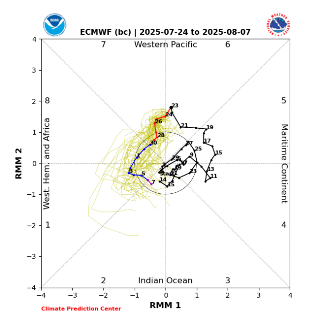
I think we see a major hurricane in the Atlantic sometime later this month, and likely a threat to land masses of the Caribbean or Western Atlantic. The MJO pattern looks set to give us a good burst just in time for late August.
Let’s see how the next two waves preform. If they develop and help moisten the mdr its game time. Until then it’s follow the vertical instability to the subtropics.
-
-
54 minutes ago, jm1220 said:
It’s about time for our August deluge. The warm 77 degree waters will give plenty of fuel.
I wouldn’t be surprised at all if someone has a flash flood emergency. Meanwhile it’s the hottest day of the season at the beach. We have had 2 heat stroke incidents with people unconscious.
-
 1
1
-
 1
1
-
-
5 hours ago, psv88 said:
The increased sharks are also eating a lot of the fish…
Saw two sharks fully breach out of the water into the air yesterday within 200 yards of the beach. Had to ban swimming for a while. Bunker pods are active but still much smaller then a few years ago.
Water temps should approach 80 today and tomorrow with light winds and excellent solar heating. That means hot right to the beaches with little sea breeze relief.
-
9 hours ago, LibertyBell said:
we have had plenty of rain, one can argue it's too much rain. This is our first four day period without rain since early June. I only expect or want rain one day per week at most.
I Live in you’re town. Do you drive around?
During the last big rain event you referenced JFK getting 2”. There was a very sharp cutoff at the queens border. We received around an inch total. Since then nearly every convective event has missed. We are sitting in the 1.5” range for the last 30 days. That is in no way sufficient for peak solar insulation. This is a reoccurring theme the last few years. As we seem to rely on convection almost exclusively for summer rain. Our ecosystem developed with more spread out synoptic stratoform rains. Not just convection.
The opinion posts are tiring and a big part of why myself and others post allot less here.I get it you love heat and hate rain in the summer. Move to fuking phoenix and be in you’re glory.
-
 1
1
-
-
6 hours ago, qg_omega said:
I do not need rain
I fixed it for you. Speak for you’re location. This area contains many micro climates. Parts of the east end of the island received .05” during the big New Jersey and lower Hudson Valley flood event. It’s like claiming a region was hit by a hurricane because of a micro burst. Something that is still open to interpretation with colonial weather observations.
-
5 hours ago, GaWx said:
From JB today fwiw: he likes to look at Euro AI ensemble members (ever since that product became available earlier this summer) vs EPS/GEFS and he’s also considering EPS’ MJO forecast: this period is before the increasingly active week that yesterday’s Euro Weeklies showed
Day 15 06 z AI ends like this with a trough in the Tennessee Valley.
and a spray of cyclones suggesting an east coast impact threat
AI VV patterns in the 10-15 are bullish for the tropics
which would mean a stronger rotation into phases 8,1,2,3
more so than the euro ensembleEuro AI relies on pattern analogs. Which Jb loves so I’m not at all surprised he has an affinity for it. To me, it looks dead until the 3rd week of August. Shear and dry air are still lurking.
-
 1
1
-
 1
1
-
-
22 minutes ago, Brian5671 said:
getting to the point where we need a 1/2 to 1 day rainer....nothing in the cards in that dept
Going to need something tropical/sub tropical for that. And it looks dead until at least late August.
-
30 minutes ago, lee59 said:
Not as uncomfortable today as I thought it might be, need rain.
Yeah it’s getting dry. Burned lawns and wilting plants. Pretty par for the course for summer near the coast. Last year was exceptional and second only to the summer 95 Hamptons fire summer drought.
Tomorrow looks good for .5-1” for anyone that gets under good convection. -
1 hour ago, jm1220 said:
If we get a bunch of offshore wind days behind cool fronts, the SSTs will cool down from upwelling. The warm waters here are shallow. But no doubt if we go through Aug with these warm waters we’re asking for trouble-either from a tropical system or stalled out front and MCS deluge like we saw last summer and happens most frequently in August around here.
What the water temps are within 25 miles of the coast has little impact on any tropical activity up here. Because we have some of the longest and shallowest continental shelf in the world. Super shallow water has little to no OHC. That’s why it’s left off OHC maps.
What we need to focus on is the water temps from 50 to 300 miles off the coast. And those waters are less effected by localized upwelling events. Those waters are currently near record warm.
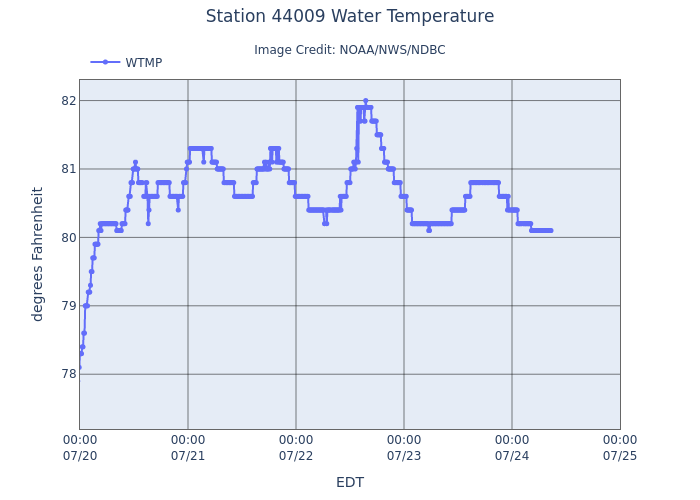
Here’s the Delaware bay buoy
-
 1
1
-
 1
1
-


OBS for moderate coastal impact Nor'easter Sun-Mon 10/12-13/25 with needed rain everywhere. To minimize any disruptions review NWS warnings-statements.
in New York City Metro
Posted
Coastal geomorphology. That tight right 90 degree angle is the perfect surge enhancer. That’s why the big bend in Florida is also so surge prone. Along with our enormous shallow continental shelf. One of the biggest in the world.